Kou-Kamma Local Municipality

Last updated

Kou-Kamma
Kou-Kamma CoA.png
Map of the Eastern Cape with Kou-Kamma highlighted.svg
Location in the Eastern Cape
Coordinates: 33°57′S24°17′E / 33.950°S 24.283°E / -33.950; 24.283
Country South Africa
Province Eastern Cape
District Sarah Baartman
Seat Kareedouw
Wards 6
Government
[1]
  Type Municipal council
  MayorMpumelelo Samuel Vuso (ANC)
  SpeakerMpumelelo Samuel Vuso (Mayor and Speaker) (ANC)
  Chief WhipFuzile Jan Yake (ANC)
Area
  Total3,593 km2 (1,387 sq mi)
Population
 (2011) [2]
  Total40,663
  Density11/km2 (29/sq mi)
Racial makeup (2011)
[2]
   Black African 30.6%
   Coloured 59.8%
   Indian/Asian 0.3%
   White 8.2%
First languages (2011)
[2]
   Afrikaans 73.8%
   Xhosa 19.9%
   English 2.7%
   Sotho 1.1%
  Other2.5%
Time zone UTC+2 (SAST)
Municipal codeEC109

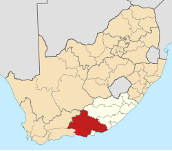
Kou-Kamma Municipality (Afrikaans : Kou-Kamma Munisipaliteit; Xhosa : uMasipala wase Kou-Kamma) is a local municipality in South Africa. It is situated in the southwest corner of the Sarah Baartman District Municipality along the Indian Ocean coastline, in the southwestern sector of South Africa's Eastern Cape province. To the west lies the Western Cape. Kou-Kamma also borders the Dr Beyers Naudé Local Municipality in the north and the Kouga Local Municipality to the east. The geographical area of the municipality is 12,540 square kilometres.

Contents

Its name is a blend of the names of the Kouga (Kou-) and Tsitsikamma (-Kamma) mountains, which in turn were named after the rivers Kouga and Tsitsikamma. [3]

The municipality is a relatively poor area with high unemployment and low levels of literacy. Settlements tend to be scattered, which has posed challenges to the provision of infrastructure and basic services such as water, sanitation, and electricity. The Kou-Kamma Municipality is composed of two distinct regions: the coastal belt (referred to as the Tsitsikamma or the Western Coastal Zone, which includes settlements such as Coldstream, Stormsrivier and Clarkson), and the inland area of the Langkloof (including settlements such as Kareedouw, Tweeriviere, Joubertina and Louterwater). The two areas are separated by the Tsitsikamma Mountains. The nature of the two areas differs vastly. The Coastal Zone is characterised by a diverse and fast-growing economy driven by tourism and agriculture, a fast-growing population linked to the economic opportunities, a good water supply, and a wealth of holiday destinations and indigenous forests. In contrast, employment in the Langkloof is characterised by seasonal agriculture with high labour requirements. The area has greater challenges in terms of sufficient water supply, with additional pressure due to a high population growth related to migrant labour. [4]

Main places

The 2001 census divided the municipality into the following main places: [5]

PlaceCodeArea (km2)PopulationMost spoken language
Boskop 20901 1.03531 Xhosa
Coldstream 20902 3.26954 Afrikaans
Joubertina 20903 2.68845Afrikaans
Kagiso Height 20904 0.09854Xhosa
Kareedouw 20905 1.67743Afrikaans
Krakeel Rivier 20907 1.231,667Afrikaans
Louterwater 20908 1.032,535Afrikaans
Sandrif 20909 1.631,872Afrikaans
Stormsrivier 20910 1.67598Afrikaans
Thornham 20911 3.851,026Afrikaans
Tsitsikamma National Park 20912 11.05284Afrikaans
Tweeriviere 20913 0.643,995Afrikaans
Uitkyk 20914 1.212,303Afrikaans
Witelsbos 20915 2.4742Afrikaans
Woodslands 20916 0.351,304Afrikaans
Remainder of the municipality 20906 3,541.3514,729Afrikaans

Politics

The municipal council consists of eleven members elected by mixed-member proportional representation. Six councillors are elected by first-past-the-post voting in six wards, while the remaining five are chosen from party lists so that the total number of party representatives is proportional to the number of votes received. In the election of 1 November 2021 the African National Congress (ANC) won six seats on the council. The following table shows the results of the election. [6]

PartyWardListTotal
seats
Votes%SeatsVotes%Seats
African National Congress 4,59544.3854,95748.3316
Democratic Alliance 2,62925.3903,03229.5633
Patriotic Alliance 1,09410.5701,15011.2111
Independent candidates 1,28012.3611
Freedom Front Plus 2702.6103133.0511
4 other parties4864.6908047.8400
Total10,354100.00610,256100.00612
Valid votes10,35497.7610,25697.40
Invalid/blank votes2372.242742.60
Total votes10,591100.0010,530100.00
Registered voters/turnout20,64551.3020,64551.01

Related Research Articles

<span class="mw-page-title-main">George Local Municipality</span> Local municipality in Western Cape, South Africa

George Municipality is a local municipality within the Garden Route District Municipality, in the Western Cape province of South Africa. As of 2011, the population is 193,672. Its municipality code is WC044.

<span class="mw-page-title-main">Bitou Local Municipality</span> Local municipality in Western Cape, South Africa

Bitou Municipality, formerly known as Plettenberg Bay Municipality, is a local municipality within the Garden Route District Municipality, in the Western Cape province of South Africa. Its municipality code is WC047.

<span class="mw-page-title-main">Sarah Baartman District Municipality</span> District municipality in Eastern Cape, South Africa

The Sarah Baartman District Municipality, formerly the Cacadu District Municipality, is situated in the western part of the Eastern Cape province of South Africa, covering an area of 58,242 square kilometres. The area of the district municipality includes seven local municipalities. The seat is the city of Gqeberha, although Gqeberha is not itself in the district. As of 2011, the languages most spoken among the 388,201 inhabitants were isiXhosa and Afrikaans. The district code is DC10.

<span class="mw-page-title-main">2006 South African municipal elections</span>

Municipal elections were held in South Africa on 1 March 2006, to elect members to the local governing councils in the municipalities of South Africa. The municipalities form the local government of South Africa and are subdivisions of the provinces, thus making them responsible for local service delivery, such as electricity, water and fire services.

<span class="mw-page-title-main">Kamiesberg Local Municipality</span> Local municipality in Northern Cape, South Africa

Kamiesberg Municipality is a local municipality within the Namakwa District Municipality, in the Northern Cape province of South Africa.

<span class="mw-page-title-main">Tsitsikamma Mountains</span> Mountain range in Western Cape, South Africa

The Tsitsikamma mountains form an east-west mountain range located in the Garden Route region of the southern South African coast in the Western Cape and Eastern Cape provinces. Tsitsikamma means 'place of much water' in the Khoekhoe language.

<span class="mw-page-title-main">Nyandeni Local Municipality</span> Local municipality in Eastern Cape, South Africa

Nyandeni Municipality is a local municipality within the OR Tambo District Municipality, in the Eastern Cape province of South Africa. Its administrative seat is the town of Libode. The entire municipal area falls within the former Transkei Bantustan area. The urban population is mainly located in the two small towns of Libode and Ngqeleni.

<span class="mw-page-title-main">Sunday's River Valley Local Municipality</span> Local municipality in Eastern Cape, South Africa

Sundays River Valley Local Municipality is a local municipality in Sarah Baartman District Municipality, Eastern Cape, South Africa. It has a total population of nearly 70,000 people. This area is one of the key production areas for citrus in South Africa. It also encompasses the Addo Elephant National Park and other significant areas of nature conservation.

The Langkloof is a 160 km long valley in South Africa, lying between Herold, a small village northeast of George, and The Heights - just beyond Twee Riviere.

The Baviaanskloof River is a river flowing through the Cape Fold Mountains of the Western Cape and eventually Eastern Cape provinces of South Africa. The river's origin is in the eastern extremity of the Little Karoo, and follows a valley between these mountains eastwards. It ends at a confluence with the Kouga River, some 80 km from its source.

<span class="mw-page-title-main">Emthanjeni Local Municipality</span> Local municipality in Northern Cape, South Africa

Emthanjeni Municipality is a local municipality within the Pixley ka Seme District Municipality, in the Northern Cape province of South Africa. Emthanjeni is a Xhosa word meaning "vein", symbolising the importance of an underground water supply system to the area. It is also a translation of the name of the municipality's seat, De Aar.

<span class="mw-page-title-main">Kouga Local Municipality</span> Local municipality in Eastern Cape, South Africa

Kouga Municipality is a local municipality in the Eastern Cape of South Africa, approximately 80 km west of Gqebera. It forms part of the Sarah Baartman District Municipality. Its territory includes the coastal zone between the Van Stadens River in the east and the Tsitsikamma River in the west, and stretches inland towards the Baviaanskloof Mountains in the north.

<span class="mw-page-title-main">Kareedouw</span> Town in the Eastern Cape province of South Africa

Kareedouw is a town in the Eastern Cape province of South Africa. It is the administrative centre for the Kou-Kamma Municipality in the Sarah Baartman District of the Eastern Cape.

<span class="mw-page-title-main">Joubertina</span> Place in Eastern Cape, South Africa

Joubertina is a small town in the Kou-Kamma Local Municipality, Sarah Baartman District of the Eastern Cape province of South Africa.

Kromme Dam, is a multi-arch type dam located at the Kromme River, near Kareedouw, Eastern Cape, in South Africa. It was established in 1943 and its main purpose is for municipal and industrial usage.

<span class="mw-page-title-main">Kouga River</span> River in the Eastern Cape, South Africa

The Kouga River originates near Uniondale, Eastern Cape, South Africa, and flows eastward, where it joins the Groot River to form the Gamtoos just past the Kouga Dam. Its main tributary is the Baviaanskloof River, which joins its left bank before the dam.

<span class="mw-page-title-main">Matatiele Local Municipality</span> Local municipality in Eastern Cape, South Africa

Matatiele Municipality is a local municipality within the Alfred Nzo District Municipality, in the Eastern Cape province of South Africa. It adjoins Lesotho to the north, Elundini to the south-west, and Greater Kokstad to the east and its 4,352 km² makes the Matatiele Municipality largest of four municipalities in the district at almost half of its geographical area. According to the South African National Census of 2011, its 203,483 residents and 49,527 households makes Matatiele Municipality the second largest populated area in the Alfred Nzo District Municipality behind Mbizana.

<span class="mw-page-title-main">Intsika Yethu Local Municipality</span> Local municipality in Eastern Cape, South Africa

Intsika Yethu Municipality is a local municipality within the Chris Hani District Municipality, in the Eastern Cape province of South Africa. The municipality is one of the six local municipality in this district. Intsika Yethu is an isiXhosa word meaning "our pillars".

The Eastern Cape province of South Africa is governed in a parliamentary system in which the people elect the provincial legislature and the legislature, in turn, elects the Premier as head of the executive. The Premier leads an Executive Council consisting of members who oversee various executive departments. The structure of the provincial government is defined by chapter six of the Constitution of South Africa.

The Kou-Kamma Local Municipality council consists of twelve members elected by mixed-member proportional representation. Six councillors are elected by first-past-the-post voting in six wards, while the remaining six are chosen from party lists so that the total number of party representatives is proportional to the number of votes received.

References

  1. "Contact list: Executive Mayors". Government Communication & Information System. Archived from the original on 14 July 2010. Retrieved 22 February 2012.
  2. 1 2 3 "Statistics by place". Statistics South Africa. Retrieved 27 September 2015.
  3. Local and district municipality's names, South African Geographical Names System, archived from the original on 12 October 2004
  4. "Kou-Kamma Municipality – Integrated Development Plan: 2007-2012" (PDF). Retrieved 5 October 2009.[ dead link ]
  5. Lookup Tables - Statistics South Africa [ permanent dead link ]
  6. "Election Result Table for LGE2021 — Kou-Kamma". wikitable.frith.dev. Retrieved 30 December 2021.