Aberdeen is a small town in the Sarah Baartman District Municipality of the Eastern Cape province of South Africa. With its numerous examples of Victorian architecture, it is one of the architectural conservation areas of the Karoo.

Beaufort West is a town in the Western Cape province in South Africa. It is the largest town in the arid Great Karoo region, and is known as the "Capital of the Karoo". It forms part of the Beaufort West Local Municipality, with 34 085 inhabitants in 2011.

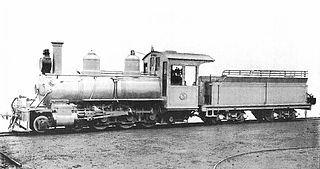
The South African Railways Class NG G13 2-6-2+2-6-2 of 1927 was a narrow gauge articulated steam locomotive.

The Langkloof Mountains are a short mountain range within the Cape Fold Belt in the Western Cape of South Africa. They form a link between the Outeniqua and Tsitsikamma mountains to the north of Plettenberg Bay in the Garden Route region. They stretch from Prince Alfred's Pass in the west to just north of Nature's Valley and south of Joubertina.

The South African Railways Class NG15 2-8-2 is a class of narrow-gauge steam locomotive.

The Kou-Kamma Municipality is a local municipality in South Africa. It is situated in the southwest corner of the Sarah Baartman District Municipality along the Indian Ocean coastline, in the southwestern sector of South Africa's Eastern Cape Province. To the west lies the Western Cape Province. Kou-Kamma also borders the Baviaans Local Municipality in the north and the Kouga Local Municipality to the east. The geographical area of the Municipality is 12,540 square kilometres. Its name is a blend of the names of the Kouga (Kou-) and Tsitsikamma (-Kamma) mountains, which in turn were named after the rivers Kouga and Tsitsikamma.
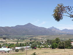
The Langkloof is a 160 km long valley in South Africa, lying between Herold, a small village northeast of George, and The Heights - just beyond Twee Riviere.

The R62 is a provincial route in South Africa that connects Ashton with Humansdorp. The R62 runs through the Little Karoo and the Langkloof, passing through Montagu, Ladismith, Calitzdorp, Oudtshoorn, and Joubertina.

The Avontuur Railway is a closed railway line between Port Elizabeth and the town of Avontuur in the Western and Eastern Cape provinces of South Africa. It is the longest 2 ft narrow gauge route in the world at a length of 285 kilometres (177 mi). "Avontuur" is the Afrikaans and Dutch word for "adventure".

Kareedouw is a town in the Eastern Cape province of South Africa. It is the administrative centre for the Kou-Kamma Municipality in the Sarah Baartman District of the Eastern Cape.

Burgersdorp is a medium-sized town in Walter Sisulu in the Joe Gqabi District Municipality of the Eastern Cape province of South Africa.

The South African Railways Class 91-000 of 1973 was a narrow-gauge diesel–electric locomotive.

Haarlem is a settlement in Garden Route District Municipality in the Western Cape province of South Africa.
The South African Railways Class NG5 2-8-2 of 1922 was a narrow-gauge steam locomotive.
The South African Railways Class NG8 4-6-0 of 1904 was a narrow-gauge steam locomotive from the pre-Union era in the Cape of Good Hope.

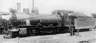
The South African Railways Class NG10 4-6-2 of 1916 was a narrow-gauge steam locomotive.

Steytlerville is a settlement in Sarah Baartman District Municipality in the Eastern Cape province of South Africa.

Avontuur is a town situated in the Garden Route District Municipality in the Western Cape province of South Africa. The town is located 13km south-east of Uniondale on an intersection of the R339 and R62 regional routes.

Krakeel River is a town in Sarah Baartman District Municipality in the Eastern Cape province of South Africa.
Twee Riviere is a town in Sarah Baartman District Municipality in the Eastern Cape province of South Africa.