Queenstown, Eastern Cape

Last updated

Queenstown
Komani
Queenstown se stadsaal.jpg
Queenstown City Hall
Nickname(s): 
Rose Capital of South Africa
South Africa Eastern Cape location map.svg
Red pog.svg
Queenstown
South Africa adm location map.svg
Red pog.svg
Queenstown
Africa location map.svg
Red pog.svg
Queenstown
Coordinates: 31°54′S26°53′E / 31.900°S 26.883°E / -31.900; 26.883 Coordinates: 31°54′S26°53′E / 31.900°S 26.883°E / -31.900; 26.883
Country South Africa
Province Eastern Cape
District Chris Hani
Municipality Enoch Mgijima
Established1853
Area
[1]
  Total71.3 km2 (27.5 sq mi)
Population
 (2011) [1]
  Total68,872
  Density970/km2 (2,500/sq mi)
Racial makeup (2011)
[1]
   Black African 81.8%
   Coloured 10.0%
   Indian/Asian 1.1%
   White 6.5%
  Other0.6%
First languages (2011)
[1]
   Xhosa 75.2%
   Afrikaans 13.8%
   English 7.3%
  Other3.7%
Time zone UTC+2 (SAST)
Postal code (street)
5320
PO box
5319
Area code 045

Queenstown, officially Komani, [2] is a town in the middle of the Eastern Cape Province of South Africa, roughly halfway between the smaller towns of Cathcart and Sterkstroom on the N6 National Route. The town was established in 1853 and is currently the commercial, administrative, and educational centre of the surrounding farming district.

Contents

History

Queenstown was founded in early 1853 under the direction of Sir George Cathcart, who named the settlement, and then fort, after Queen Victoria. Work on its railway connection to East London on the coast was begun by the Cape government of John Molteno in 1876, and the line was officially opened on 19 May 1880. [3]

The town war memorial was designed by Sir Robert Lorimer in 1922 with its sculpture by Alice Meredith Williams. [4]

The town prospered from its founding up to the worldwide depression of the 1930s, and again thereafter. In the 1960s, the majority of the Black population were moved east to the township of Ezibeleni, as part of the attempt to move African people to so-called "homelands". The area has in the past had very severe weather problems, luckily, often only affecting the surrounding areas. In 2002, heavy snowfall around Queenstown caused a severe disaster, especially since the area was not funded or ready for such a disaster. [5] Then, in 2004, the surrounding areas of the Eastern Cape were affected by strong winds and heavy rainfall, [6] although Queenstown once again escaped much flooding and some wind damage, power shortages soon followed. Other natural disasters include droughts [7] and veld fires (wildfires). [8]

The name of the town was changed to Komani in February 2016. [2]

Education

The following high schools serve the town and surrounding areas:

Primary schools in the area include:

Tertiary education institutions in Queenstown include

Religion

The city is the seat of the Roman Catholic Diocese of Queenstown as well as the Anglican Church's Diocese of Ukhahlamba. The imposing Cathedral of St. Michael lies adjacent to the town's public gardens. [9] Churches of all faith denominations are to be found in and around the town.

Geography

The town lies on the Komani River which forms part of the Great Kei system of rivers and has a refreshing climate and plentiful water supply from the surrounding rugged mountains. The water is collected in the Bongolo Dam, set in the hills, used extensively for recreation and watersports. Each year, around the beginning of June, the town holds an art exhibition with the emphasis on paintings and sculpture. Perhaps inspired by some of the most interesting Bushman paintings in nearby caves, which are accessible to the visitor.

Close to the town is a nature reserve (Lawrence de Lange Game Reserve) with numerous antelope, white rhinoceros and spectacular flowering plants together with panoramic views from the mountain summit.

Layout

Komani Hexagon Komani Hexagon Square.jpg
Komani Hexagon

The layout of the town reflects its original objective as a defensive stronghold for the frontier area and has a most unusual design. There is a central hexagonal area where canon or rifle fire could be directed down six thoroughfares radiating from the centre. The canon sites have now been replaced with gardens and a central fountain was the dominant feature. A striking abstract sculpture replaced the fountain as part of the town's 150th anniversary. The hexagon still exists, with the outer road surrounding it named Robinson Road, which encircles it. Surrounding the Hexagon to the east and west lies more commercial and administrative facilities.

Currently, formerly 'white suburbs' (Sandringham, Kingsway, Windsor, Bergsig, Blue rise, Balmoral, Madeira Park and a new fast-growing suburb of Komani Park) surround the hexagon to the north, east and west, however, one of the city's great townships (and squatter camps) lies to the south. It is a collection of black and coloured townships named Mlungisi, Aloevale, a new township, Victoria Park has been built to the south-east of the city. East of the town lies the much larger Ezibeleni township, which although roughly the same surface area as the main town, has by far a larger population.

Climate

Queenstown has a cold semi-arid climate (Köppen climate classification: BSk), that borders on a subtropical highland climate (Köppen climate classification: Cfb), and a humid subtropical climate (Köppen climate classification: Cfa).

Climate data for Queenstown
MonthJanFebMarAprMayJunJulAugSepOctNovDecYear
Record high °C (°F)40.6
(105.1)
40.0
(104.0)
37.2
(99.0)
34.0
(93.2)
31.1
(88.0)
26.1
(79.0)
26.4
(79.5)
31.1
(88.0)
35.0
(95.0)
37.8
(100.0)
38.1
(100.6)
40.0
(104.0)
40.6
(105.1)
Average high °C (°F)29.3
(84.7)
28.7
(83.7)
27.0
(80.6)
23.9
(75.0)
20.6
(69.1)
18.3
(64.9)
18.2
(64.8)
20.2
(68.4)
22.9
(73.2)
24.7
(76.5)
26.4
(79.5)
28.6
(83.5)
24.2
(75.6)
Daily mean °C (°F)21.9
(71.4)
21.7
(71.1)
20.1
(68.2)
16.6
(61.9)
13.3
(55.9)
10.6
(51.1)
10.6
(51.1)
12.4
(54.3)
15.1
(59.2)
17.1
(62.8)
19.0
(66.2)
21.1
(70.0)
16.7
(62.1)
Average low °C (°F)14.5
(58.1)
14.7
(58.5)
13.3
(55.9)
9.4
(48.9)
6.0
(42.8)
3.0
(37.4)
2.9
(37.2)
4.6
(40.3)
7.3
(45.1)
9.5
(49.1)
11.6
(52.9)
13.5
(56.3)
9.2
(48.6)
Record low °C (°F)3.9
(39.0)
3.9
(39.0)
1.5
(34.7)
−1.1
(30.0)
−5.5
(22.1)
−6.7
(19.9)
−7.5
(18.5)
−6.7
(19.9)
−3.8
(25.2)
−1.7
(28.9)
0.1
(32.2)
3.0
(37.4)
−7.5
(18.5)
Average precipitation mm (inches)77
(3.0)
88
(3.5)
83
(3.3)
40
(1.6)
24
(0.9)
14
(0.6)
13
(0.5)
16
(0.6)
26
(1.0)
40
(1.6)
58
(2.3)
72
(2.8)
551
(21.7)
Average precipitation days (≥ 0.1 mm)10.611.011.07.35.43.03.03.64.58.28.69.085.2
Average relative humidity (%)64686866625854525661646261
Source: Deutscher Wetterdienst [10]

Geology

The Queenstown area is in the Burgersdorp Formation of the Tarkastad sub group, in the upper Beaufort Group Triassic in age in the karoo super group. The lithology is red mudstone 1 to 10 m rich layers and sub-ordinate 1 to 2 m rich sandstone layers deposited by meandering rivers in the flood plain in an oxidising environment gradually filling the Karoo basin. The formation reaches thickness of 600 m in the Komani (Queenstown) and Lady Frere area. Numerous dolerite dykes and ring structures intruded the area creating good localities for ground water exploration.

Media

The town has a newspaper called The Representative, fondly known as the Rep, as well as The Express and a community radio station, Lukhanji fm. The Eastern Cape newspaper, Daily Dispatch, is widely read in the area.

Coats of arms

The Queenstown municipal council assumed a pseudo-heraldic coat of arms in October 1902. [11] The shield was quartered, and depicted (1) the Union Jack, (2) a landscape with hangklip mountain in the background, (3) a landscape with a mimosa tree in the foreground, and (4) a portrait of King Edward VII. The crest was a demi-antelope, and the motto Unity is strength. [12] The council later assumed a new coat of arms. The new shield displayed a golden royal coronet on a red background. The crest was the same as before, but the motto was translated into Latin as Ex unitate vires. [13]

Notable people

Related Research Articles

Queenstown, New Zealand Resort town in Otago, New Zealand

Queenstown is a resort town in Otago in the south-west of New Zealand's South Island. It has an urban population of 15,450.

Kimberley, Northern Cape Place in Northern Cape, South Africa

Kimberley is the capital and largest city of the Northern Cape Province of South Africa. It is located approximately 110 km east of the confluence of the Vaal and Orange Rivers. The city has considerable historical significance due to its diamond mining past and the siege during the Second Anglo-Boer war. British businessmen Cecil Rhodes and Barney Barnato made their fortunes in Kimberley, and Rhodes established the De Beers diamond company in the early days of the mining town.

East London, Eastern Cape Place in Eastern Cape, South Africa

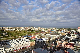
East London is a city on the southeast coast of South Africa in the Buffalo City Metropolitan Municipality of the Eastern Cape province. The city lies on the Indian Ocean coast, largely between the Buffalo River and the Nahoon River, and hosts the country's only river port. As of 2011, East London had a population of over 267,000 with over 755,000 in the metropolitan area.

Eastern Cape Province of South Africa

The Eastern Cape is one of the provinces of South Africa. Its capital is Bisho, but its two largest cities are East London and Gqeberha.

Stellenbosch Place in Western Cape, South Africa

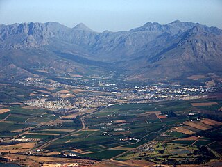
Stellenbosch is a town in the Western Cape province of South Africa, situated about 50 kilometres east of Cape Town, along the banks of the Eerste River at the foot of the Stellenbosch Mountain. It is the second oldest settlement in the province, after Cape Town. The town became known as the City of Oaks or Eikestad in Afrikaans and Dutch due to the large number of oak trees that were planted by its founder, Simon van der Stel, to grace the streets and homesteads.

Dordrecht, Eastern Cape Place in Eastern Cape, South Africa

Dordrecht is a town situated in the Eastern Cape Province of South Africa. Dordrecht was founded in 1856 by Baron Smiddolff, a minister of the Dutch Reformed Church. The town was named for the city of the same name in the South-Western Netherlands and had a population of about 8,741 people in 2001.

Bethlehem, Free State Place in Free State, South Africa

Bethlehem is a city in the eastern Free State province of South Africa that is situated on the Liebenbergs river along a fertile valley just north of the Rooiberg Mountains on the N5 road. It is the fastest growing city in the Free state province, with its target of being the third largest city after Bloemfontein and Welkom.

The following lists events that happened during 1985 in South Africa.

Strand, Western Cape Seaside town in the Western Cape, South Africa

Strand is a seaside resort town in the Western Cape, South Africa. It forms part of the Helderberg region of the City of Cape Town Metropolitan Municipality, situated on the north-eastern edge of False Bay and near the foot of the Helderberg Mountains. Its geographical position is between Somerset West and Gordon's Bay, and is about 50 km southeast of Cape Town City Bowl. Strand is in the Western Cape province of South Africa, and has a population of approximately 50,000. Strand's main attraction is the beach; 5 km of white sandy beach off False Bay.

Port Elizabeth Place in Eastern Cape, South Africa

Port Elizabeth, officially renamed Gqeberha and colloquially often referred to as PE, is a major seaport city and the most populous city in the Eastern Cape province of South Africa. It is the seat of the Nelson Mandela Bay Metropolitan Municipality, South Africa's second-largest metropolitan district by area size. It is the sixth-most-populous city in South Africa and is the cultural, economic and financial centre of the Eastern Cape.

Manzini, Eswatini Largest city of Eswatini

Manzini is a city in Eswatini (Swaziland), which is also the capital of Eswatini's Manzini Region. The city is the country's largest urban center ahead of Mbabane, with a population of 110,000 (2008). It is known as "The Hub" of Eswatini and lies on the MR3 road. Eswatini's primary industrial site at Matsapha lies near the town's western border.

Cathcart, Eastern Cape Place in Eastern Cape, South Africa

Cathcart is a town in the Eastern Cape province of South Africa, named after Sir George Cathcart, governor of the Colony of the Cape of Good Hope 1852–1853. The town is situated on the N6, 48 kilometres (30 mi) north of Stutterheim en route to Komani.

Tarkastad Place in Eastern Cape, South Africa

Tarkastad is a Karoo semi-urban settlement situated on the banks Tarka River in the Eastern Cape province of South Africa. Tarkastad is on a plain to the north of the Winterberg mountain range on the R61 between Cradock and Queenstown and only three hours from Port Elizabeth. The name Tarkastad is believed to come from the Khoi-Khoi word Traka or the Celtic word Tarka and the Afrikaans word Stad. The fact that the town is overlooked by Martha and Mary; two peaks which look like two women resting after a hard day's work, also lends to the name.

Whittlesea, Eastern Cape Place in Eastern Cape, South Africa

Whittlesea is a semi-rural town situated in the Hewu district, 37 km south of Queenstown, Eastern Cape Province, South Africa. The town is made up of the townships Ekuphumleni, Bhede, Extension 4, Extension 5 and Sada. The town falls under the Enoch Mgijima Local Municipality which is under the Chris Hani District Municipality. Surrounding Whittlesea are 36 villages which make up the Hewu district.

Tsolwana Nature Reserve Nature reserve on the edge of the Winterberg Mountain range in Eastern Cape Province, South Africa

Tsolwana Nature Reserve is an 8,500 hectare nature reserve situated on the edge of the Winterberg Mountain range. It is located 60 km west of Queenstown, and 30 km south- east of Tarkastad in Eastern Cape Province, South Africa and is managed by Eastern Cape Parks Board. Its western boundary is formed by the upper Black Kei River. The reserve's name originates from the Xhosa word for "spike", due to the presence of the cone-shaped hill, Spitskop.

Ezibeleni Place in Eastern Cape, South Africa

Ezibeleni is a township in the Eastern Cape Province of South Africa. It was established in the 1960s and officially recognised in 1974, when black South Africans were not allowed to live, but only to work, in the white-dominated Queenstown. In order to pursue the policy of separate development, the apartheid-era government of the time dictated that, due to its location on the map and the predominant Xhosa ethnicity of its people, Ezibeleni would belong to Transkei, one of ten fragmented batustans, or homelands, scattered across South Africa.

Komani River River in the Eastern Cape, South Africa

The Komani River, is a river part of the Great Kei River system in the Eastern Cape, South Africa. It is a short river originating north of Queenstown and joining up with the Klaas Smits River, just south of the same town.

Jamestown, Eastern Cape Place in Eastern Cape, South Africa

Jamestown is a town on the N6 national road 58 km south of Aliwal North and 105 km north of Komani in the Joe Gqabi District Municipality of the Eastern Cape, South Africa. It is at the centre of a fertile sheep, cattle and wheat-farming area and was the terminus of a branch railway line from Molteno. It was named after James Wagenaar, original owner of the farm on which the town was laid out.

Sada, Eastern Cape Place in Eastern Cape, South Africa

Sada is a semi-rural settlement, situated 3 km away from Whittlesea, 30 km north of Seymour and 40 km south of Queenstown, Eastern Cape Province. The word Sada means "finally" or "at last" in isiXhosa because the first settlers struggled to find a place before they settled in the area in 1964.

Queenstown Massacre

On 17 November 1985, 2000 residents from Mlungisi township in Queenstown, Eastern Cape, gathered in Nonzwakazi Methodist Church to hear back from the Local Residents Association, who, in early November, had met with the Department of Education and Training, the Queenstown municipality, the Eastern Cape Development Board, and the Queenstown Chamber of Commerce to discuss the end of the consumer boycott. The meeting was short-lived as members of the Queenstown branch of the South African Police stormed into the meeting and opened fire on the residents. In the ensuing conflict between police and residents, 14 people were shot dead and 22 were injured. This incident is known as the 1985 Queenstown Massacre.

References

  1. 1 2 3 4 Sum of the Main Places Queenstown and Mlungisi from Census 2011.
  2. 1 2 "Government Gazette No. 39669" (PDF). South African Government. 9 February 2016. p. 9. Retrieved 11 October 2018.
  3. Burman, Jose (1984). Early railways at the Cape. Human & Rousseau. p. 86.
  4. Basic biographical details of Sir Robert Stodart Lorimer at the Dictionary of Scottish Architects Biographical Database.
  5. Raasch, Sonja (22 July 2002). "Snow rescue teams bring relief". Archived from the original on 1 September 2003.
  6. Prince, Chandré (27 September 2004). "Weekend weather batters Eastern Cape". Archived from the original on 8 November 2004.
  7. "Water drying up in north-eastern Cape". 30 August 1999. Archived from the original on 21 October 2012.
  8. Raasch, Sonja (31 August 1999). "Stofile demands facts on veld fire damage". Archived from the original on 12 May 2006.
  9. Menache, Philippe; David, Darryl Earl (2015). Church Tourism in South Africa: A Travel Odyssey : Also Featuring, On Tour with Wynand Louw. Menache and David (Self published). p. 28. ISBN   978-0-620-67799-8.
  10. "Klimatafel von Queenstown, Prov. Eastern Cape / Südafrika" (PDF). Baseline climate means (1961–1990) from stations all over the world (in German). Deutscher Wetterdienst. Retrieved 19 November 2016.
  11. Western Cape Archives : Queenstown Municipal Minutes (29 October 1902).
  12. The arms were depicted on a cigarette card issued in 1931.
  13. The arms are illustrated (in black and white) in the Official South African Municipal Yearbook (1983).
  14. "sahistory.org.za".
  15. "THE FORMAL FORMATION OF THE NCAW". National Council of African Women.