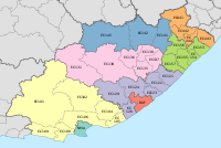
Engcobo Local Municipality

Last updated

Engcobo
Engcobo CoA.png
Map of the Eastern Cape with Engcobo highlighted (2011).svg
Location in the Eastern Cape
Country South Africa
Province Eastern Cape
District Chris Hani
Seat Ngcobo
Wards 20
Government
[1]
  Type Municipal council
  MayorSiyabulela Zangqa (ANC)
  SpeakerSkosana Mbolo (ANC)
  Chief WhipNobantu Macingwane (ANC)
Area
  Total2,484 km2 (959 sq mi)
Population
 (2011) [2]
  Total155,513
  Density63/km2 (160/sq mi)
Racial makeup (2011)
[2]
   Black African 99.6%
   Coloured 0.1%
   Indian/Asian 0.1%
   White 0.1%
First languages (2011)
[3]
   Xhosa 94.7%
   English 2.0%
  Other3.3%
Time zone UTC+2 (SAST)
Municipal codeEC137

Engcobo Municipality (Xhosa : uMasipala wase Engcobo) is a local municipality within the Chris Hani District Municipality, in the Eastern Cape province of South Africa. Ngcobo is an isiXhosa word for a sweet grass found in the area. [4]

Contents

Main places

The 2001 census divided the municipality into the following main places: [5]

PlaceCodeArea (km2)Population
Amantondo 22401 132.827,033
Amaqwati 22402 167.6516,863
Dumalisile 22403 128.988,330
Ngcobo 22404 26.556,124
Gqutyini 22405 259.7312,165
Hala 22406 185.3113,339
Jumba 22407 279.2716,774
Luhewini 22408 149.0214,707
Moshi 22409 171.9011,447
Sidindi 22410 386.9023,005
Singqumeni 22411 166.646,113
Tara 22412 46.353,190
Upper Gqobonco 22413 157.679,319

Politics

The municipal council consists of thirty-nine members elected by mixed-member proportional representation. Twenty councillors are elected by first-past-the-post voting in twenty wards, while the remaining nineteen are chosen from party lists so that the total number of party representatives is proportional to the number of votes received. In the election of 1 November 2021, the African National Congress (ANC) won a majority of thirty-two seats on the council. The following table shows the results of the election. [6]

PartyWardListTotal
seats
Votes%SeatsVotes%Seats
African National Congress 26,47381.922026,44582.071232
Economic Freedom Fighters 1,7745.4901,8045.6022
United Democratic Movement 1,6435.0801,6355.0722
African Transformation Movement 9652.9909813.0411
Democratic Alliance 5061.5704361.3511
Pan Africanist Congress of Azania 2560.7902720.8411
Independent candidates 1410.4400
5 other parties5571.7206482.0100
Total32,315100.002032,221100.001939
Valid votes32,31598.2732,22198.03
Invalid/blank votes5681.736471.97
Total votes32,883100.0032,868100.00
Registered voters/turnout70,36946.7370,36946.71

Related Research Articles

<span class="mw-page-title-main">KwaDukuza Local Municipality</span> Local municipality in KwaZulu-Natal, South Africa

KwaDukuza Local Municipality is one of four municipalities under iLembe District Municipality, KwaZulu-Natal, South Africa.
<span class="mw-page-title-main">Mbhashe Local Municipality</span> Local municipality in Eastern Cape, South Africa

Mbhashe Municipality is a local municipality in the Eastern Cape province of South Africa. The municipality was constituted in terms of the Municipal Structures Act of 1998 and comprises the areas that previously formed the Elliotdale, Willowvale and Dutywa town councils. The municipality is located in the north eastern part of the Amathole District Municipality. The main administrative office is situated in Dutywa.
<span class="mw-page-title-main">Winnie Madikizela-Mandela Local Municipality</span> Local municipality in Eastern Cape, South Africa

Winnie Madikizela-Mandela Local Municipality is a local municipality in Alfred Nzo District Municipality in the Wild Coast Region of the Eastern Cape Province in South Africa.
<span class="mw-page-title-main">Moretele Local Municipality</span> Local municipality in North West, South Africa

Moretele Municipality is a local municipality within the Bojanala Platinum District Municipality, in the North West province of South Africa. As of 2011, its population was approximately 180,000, a majority of whom speak Setswana as a first language.
<span class="mw-page-title-main">Nkomazi Local Municipality</span> Local municipality in Mpumalanga, South Africa

Nkomazi Municipality is a local municipality within the Ehlanzeni District Municipality, in the Mpumalanga province of South Africa. Malalane is the seat of the municipality.

<span class="mw-page-title-main">Mogalakwena Local Municipality</span> Local municipality in Limpopo, South Africa

Mogalakwena Municipality is a local municipality within the Waterberg District Municipality, in the Limpopo province of South Africa. The seat is Mokopane.

<span class="mw-page-title-main">City of Matlosana</span> Local municipality in North West, South Africa

The City of Matlosana, formerly the City Council of Klerksdorp, is a local municipality within the Dr Kenneth Kaunda District Municipality, in the North West province of South Africa.

uMhlathuze Local Municipality Local municipality in KwaZulu-Natal, South Africa

uMhlathuze Local Municipality is an administrative area in the King Cetshwayo District Municipality of KwaZulu-Natal in South Africa. The municipality is named after the Mhlatuze River.

<span class="mw-page-title-main">Umzimkhulu Local Municipality</span> Local municipality in KwaZulu-Natal, South Africa

Umzimkhulu Local Municipality is an administrative area in the Harry Gwala District of KwaZulu-Natal in South Africa. Umzimkhulu is a Xhosa and Zulu name meaning “Big/Great house”. Prior to the Twelfth Amendment of the Constitution of South Africa in 2005, confirmed by the Thirteenth in 2007, it was part of the Eastern Cape.

<span class="mw-page-title-main">Elundini Local Municipality</span> Local municipality in Eastern Cape, South Africa

Elundini Municipality is a local municipality within the Joe Gqabi District Municipality, in the Eastern Cape province of South Africa. The name originates from isiZulu and refers to the Drakensberg Mountains.

<span class="mw-page-title-main">Mnquma Local Municipality</span> Local municipality in Eastern Cape, South Africa

Mnquma Municipality is a local municipality within the Amatole District Municipality, in the Eastern Cape of South Africa.

<span class="mw-page-title-main">Emalahleni Local Municipality, Eastern Cape</span> Local municipality in Eastern Cape, South Africa

Emalahleni Municipality is a local municipality within the Chris Hani District Municipality, in the Eastern Cape province of South Africa. Emalahleni is an isiXhosa word meaning "a place of coal".

<span class="mw-page-title-main">Amahlathi Local Municipality</span> Local municipality in Eastern Cape, South Africa

Amahlathi Municipality is a local municipality within the Amatole District Municipality, in the Eastern Cape province of South Africa. Amahlati is an isiXhosa word meaning "a place where many trees are grouped together, a forest". Forests are a key feature of the area.
<span class="mw-page-title-main">Ngqushwa Local Municipality</span> Local municipality in Eastern Cape, South Africa

Ngqushwa Municipality is a local municipality within the Amatole District Municipality, in the Eastern Cape province of South Africa.

<span class="mw-page-title-main">Ntabankulu Local Municipality</span> Local municipality in Eastern Cape, South Africa

Ntabankulu Local Municipality is a local municipality in Alfred Nzo District Municipality in the Wild Coast Region of the Eastern Cape Province in South Africa.
uMlalazi Local Municipality Local municipality in KwaZulu-Natal, South Africa

uMlalazi Local Municipality is an administrative area in the King Cetshwayo District of KwaZulu-Natal in South Africa. The municipality is named after the uMlalazi River.

<span class="mw-page-title-main">Sakhisizwe Local Municipality</span> Local municipality in Eastern Cape, South Africa

Sakhisizwe Municipality is a local municipality within the Chris Hani District Municipality, in the Eastern Cape province of South Africa. Sakhisizwe is an isiXhosa word meaning "we are building the nation".
<span class="mw-page-title-main">Senqu Local Municipality</span> Local municipality in Eastern Cape, South Africa

Senqu Municipality is a local municipality within the Joe Gqabi District Municipality, in the Eastern Cape province of South Africa. Senqu is the Sesotho name for the Orange River.

<span class="mw-page-title-main">Raymond Mhlaba Local Municipality</span> Local municipality in Eastern Cape, South Africa

Raymond Mhlaba Municipality is a local municipality, in the Eastern Cape province of South Africa. It was established after the August 2016 local elections by merging the Nkonkobe and Nxuba local municipalities.

The Engcobo Local Municipality council consists of thirty-nine members elected by mixed-member proportional representation. Twenty councillors are elected by first-past-the-post voting in twenty wards, while the remaining nineteen are chosen from party lists so that the total number of party representatives is proportional to the number of votes received. In the election of 1 November 2021 the African National Congress (ANC) won a majority of thirty-two seats.

References

  1. "Contact list: Executive Mayors". Government Communication & Information System. Archived from the original on 14 July 2010. Retrieved 22 February 2012.
  2. 1 2 "Statistics by place". Statistics South Africa. Retrieved 27 September 2015.
  3. "Statistics by place". Statistics South Africa. Retrieved 27 September 2015.
  4. South African Languages - Place names
  5. Lookup Tables - Statistics South Africa [ permanent dead link ]
  6. "Election Result Table for LGE2021 — Engcobo". wikitable.frith.dev. Retrieved 31 December 2021.

31°40′S28°00′E / 31.667°S 28.000°E / -31.667; 28.000