Blue Crane Route Local Municipality

Last updated

Blue Crane Route
Bloukraanroete
Blue Crane Route CoA.png
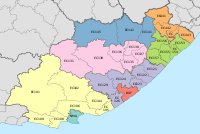
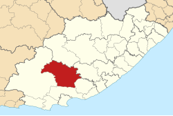
Map of the Eastern Cape with Blue Crane Route highlighted.svg
Location in the Eastern Cape
Coordinates: 32°43′S25°35′E / 32.717°S 25.583°E / -32.717; 25.583
Country South Africa
Province Eastern Cape
District Sarah Baartman
Seat Somerset East
Wards 6
Government
[1]
  Type Municipal council
  MayorBonisile Manxoweni (ANC)
  SpeakerBonisile Manxoweni (ANC) [n 1]
  Chief WhipNeliswa Nkonyeni (ANC)
Area
  Total11,068 km2 (4,273 sq mi)
Population
 (2011) [2]
  Total36,002
  Density3.3/km2 (8.4/sq mi)
Racial makeup (2011)
[2]
   Black African 59.0%
   Coloured 33.0%
   Indian/Asian 0.3%
   White 6.8%
First languages (2011)
[3]
   Xhosa 51.3%
   Afrikaans 43.2%
   English 3.4%
  Other2.1%
Time zone UTC+2 (SAST)
Municipal codeEC102

Blue Crane Route Municipality (Xhosa : uMasipala wase Blue Crane Route; Afrikaans : Bloukraanroete Munisipaliteit) is a local municipality within the Sarah Baartman District Municipality, in the Eastern Cape of South Africa. The municipality is named after the South African national bird, the blue crane. [4]

Contents

Main places

The 2001 census divided the municipality into the following main places: [5]

PlaceCodePopulationMost spoken language
Bongweni 20202 3,776 Xhosa
Cookhouse 20203 1,415Xhosa
Khayanisho 20204 1,448Xhosa
KwaNojoli 20205 8,132Xhosa
Pearston 20206 2,596Afrikaans
Petersburg 29103 39Afrikaans
Somerset East 20207 8,456Xhosa
Remainder of the municipality 20201 9,196Xhosa

Politics

The municipal council consists of eleven members elected by mixed-member proportional representation. Six councillors are elected by first-past-the-post voting in six wards, while the remaining five are chosen from party lists so that the total number of party representatives is proportional to the number of votes received. In the election of 1 November 2021, the African National Congress (ANC) won a majority of six seats on the council. The following table shows the results of the election [6]

PartyWardListTotal
seats
Votes%SeatsVotes%Seats
African National Congress 5,22356.2545,26056.5026
Democratic Alliance 3,45537.2123,45037.0624
Economic Freedom Fighters 5826.2705756.1811
African Transformation Movement 60.060250.2700
Independent candidates 200.2200
Total9,286100.0069,310100.00511
Valid votes9,28698.739,31098.75
Invalid/blank votes1191.271181.25
Total votes9,405100.009,428100.00
Registered voters/turnout17,86752.6417,86752.77

Footnotes

  1. Manxoweni serves as the Mayor, Speaker and Chairperson of the Finance Committee.

Related Research Articles

<span class="mw-page-title-main">Blouberg Local Municipality</span> Local municipality in Limpopo, South Africa

Blouberg Municipality is a local municipality within the Capricorn District Municipality, in the Limpopo province of South Africa, bordering Botswana. It takes its name from the Blouberg, a mountain range located to the west of the western end of the Soutpansberg mountain range, north west of the town of Vivo. Blouberg is home to some of the most spectacular rock climbing in South Africa. The rock climbing destination is famous for its big wall natural climbing with route lengths up to 350m. The vegetation ranges from sub-tropical savanna at the base, to alpine near the summit.
<span class="mw-page-title-main">Moretele Local Municipality</span> Local municipality in North West, South Africa

Moretele Municipality is a local municipality within the Bojanala Platinum District Municipality, in the North West province of South Africa. As of 2011, its population was approximately 180,000, a majority of whom speak Setswana as a first language.

<span class="mw-page-title-main">Siyathemba Local Municipality</span> Local municipality in Northern Cape, South Africa

Siyathemba Municipality is a local municipality within the Pixley ka Seme District Municipality, in the Northern Cape province of South Africa.

<span class="mw-page-title-main">Karoo Hoogland Local Municipality</span> Local municipality in Northern Cape, South Africa

Karoo Hoogland Municipality is a local municipality within the Namakwa District Municipality, in the Northern Cape province of South Africa. The municipality incorporates the towns of Williston, Fraserburg and Sutherland. Although the towns are separated by more than 100 km by road, they share many administrative tasks.

<span class="mw-page-title-main">Dipaleseng Local Municipality</span> Local municipality in Mpumalanga, South Africa

Dipaleseng Municipality is a local municipality within the Gert Sibande District Municipality, in the Mpumalanga province of South Africa. Balfour is the seat of the municipality.
<span class="mw-page-title-main">Moses Kotane Local Municipality</span> Local municipality in North West, South Africa

Moses Kotane Municipality is a local municipality within the Bojanala Platinum District Municipality, in the North West province of South Africa. It is named in memory of Moses Kotane. The seat of the municipality is Mogwase.

<span class="mw-page-title-main">King Sabata Dalindyebo Local Municipality</span> Local municipality in Eastern Cape, South Africa

King Sabata Dalindyebo Local Municipality is a municipality situated in the inland of Eastern Cape Province in South Africa. The municipality is made up of Mthatha and Mqanduli. The King Sabata Dalindyebo Local Municipality is one of the seven local municipalities within the Oliver Reginald Tambo District Municipality.

<span class="mw-page-title-main">Metsimaholo Local Municipality</span> Local municipality in Free State, South Africa

Metsimaholo Municipality is a local municipality within the Fezile Dabi District Municipality, in the Free State province of South Africa. Metsimaholo means "big water" in Sesotho.
<span class="mw-page-title-main">Kgatelopele Local Municipality</span> Local municipality in Northern Cape, South Africa

Kgatelopele Municipality is a local municipality within the ZF Mgcawu District Municipality, in the Northern Cape province of South Africa. Kgatelopele is a Setswana name meaning "progress".

<span class="mw-page-title-main">Endumeni Local Municipality</span> Local municipality in KwaZulu-Natal, South Africa

Endumeni Local Municipality is an administrative area in the Umzinyathi District of KwaZulu-Natal in South Africa. Endumeni is an isiZulu name meaning "a place of thunderstorm". The municipality shares its name with the Endumeni hill.

eMadlangeni Local Municipality Local municipality in KwaZulu-Natal, South Africa

eMadlangeni Local Municipality, previously known as Utrecht Local Municipality, is an administrative area in the Amajuba District of KwaZulu-Natal in South Africa.

<span class="mw-page-title-main">Magareng Local Municipality</span> Local municipality in Northern Cape, South Africa

Magareng Municipality is a local municipality within the Frances Baard District Municipality, in the Northern Cape province of South Africa.
<span class="mw-page-title-main">Ngwathe Local Municipality</span> Local municipality in Free State, South Africa

Ngwathe Municipality is a local municipality within the Fezile Dabi District Municipality, in the Free State province of South Africa. Ngwathe is the Sesotho name for the Renoster River.

<span class="mw-page-title-main">Letsemeng Local Municipality</span> Local municipality in Free State, South Africa

Letsemeng Municipality is a local municipality within the Xhariep District Municipality, in the Free State province of South Africa.
<span class="mw-page-title-main">Great Kei Local Municipality</span> Local municipality in Eastern Cape, South Africa

Great Kei Local Municipality is an administrative area in the Amathole District of the Eastern Cape in South Africa. The name "Kei" is of Khoi origin, meaning "sand". The municipality is named after the Great Kei River.

<span class="mw-page-title-main">Mhlontlo Local Municipality</span> Local municipality in Eastern Cape, South Africa

Mhlontlo Local Municipality is an administrative area in the OR Tambo District of Eastern Cape in South Africa.

<span class="mw-page-title-main">Mohokare Local Municipality</span> Local municipality in Free State, South Africa

Mohokare Municipality is a local municipality within the Xhariep District Municipality, in the Free State province of South Africa. Mohokare is the Sesotho word for the Caledon River, which runs through the municipality.

<span class="mw-page-title-main">ǃKheis Local Municipality</span> Local municipality in Northern Cape, South Africa

ǃKheis Municipality is a local municipality within the ZF Mgcawu District Municipality, in the Northern Cape province of South Africa. ǃKheis is a Khoikhoi name meaning "a place where you live, or a home". The municipality is named in recognition of the Khoekhoe people who were the first permanent dwellers of the area.
<span class="mw-page-title-main">Ingquza Hill Local Municipality</span> Local municipality in Eastern Cape, South Africa

Ingquza Hill Local Municipality, previously known as Qaukeni, is an administrative area in the OR Tambo District of Eastern Cape in South Africa.

The Blue Crane Route Local Municipality council consists of eleven members elected by mixed-member proportional representation. Six councillors are elected by first-past-the-post voting in six wards, while the remaining five are chosen from party lists so that the total number of party representatives is proportional to the number of votes received. In the election of 1 November 2021 the African National Congress (ANC) won a reduced majority of six seats.
References

  1. "Contact list: Executive Mayors". Government Communication & Information System. Archived from the original on 14 July 2010. Retrieved 22 February 2012.
  2. 1 2 "Statistics by place". Statistics South Africa. Retrieved 27 September 2015.
  3. "Statistics by place". Statistics South Africa. Retrieved 27 September 2015.
  4. South African Languages - Place names
  5. Lookup Tables - Statistics South Africa [ permanent dead link ]
  6. "Election Result Table for LGE2021 — Blue Crane Route". wikitable.frith.dev. Retrieved 18 December 2021.