Ndlambe Local Municipality

Last updated

Ndlambe
Ndlambe CoA.png
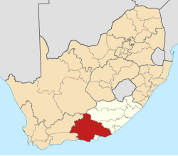
Map of the Eastern Cape with Ndlambe highlighted.svg
Location in the Eastern Cape
Coordinates: 33°36′S26°53′E / 33.600°S 26.883°E / -33.600; 26.883
Country South Africa
Province Eastern Cape
District Sarah Baartman
Seat Port Alfred
Wards 10
Government
[1]
  Type Municipal council
  MayorKhululwa Ncamiso (ANC)
  SpeakerNonkululeko Vivian Maphaphu (ANC)
  Chief WhipAndile Marasi (ANC)
Area
  Total1,841 km2 (711 sq mi)
Population
 (2022) [2]
  Total87,797
  Density48/km2 (120/sq mi)
Racial makeup (2022)
[2]
   Black African 68.2%
   Coloured 7.6%
   Indian/Asian 0.4%
   White 23.0%
First languages (2011)
[3]
   Xhosa 72.9%
   English 12.5%
   Afrikaans 11.9%
  Other2.7%
Time zone UTC+2 (SAST)
Municipal codeEC105

Ndlambe Municipality (Xhosa : uMasipala wase Ndlambe; Afrikaans : Ndlambe Munisipaliteit) is a local municipality within the Sarah Baartman District Municipality, in the Eastern Cape of South Africa. Its capital is Port Alfred. It is a predominantly rural area with agriculture and tourism dominating the economy. [4]

Contents

It encompasses the towns of Kenton-on-Sea, Boknesstrand, Bathurst, Boesmansriviermond, Alexandria, and Cannon Rocks. [5]

Politics

The municipal council consists of twenty members elected by mixed-member proportional representation. Ten councillors are elected by first-past-the-post voting in ten wards, while the remaining ten are chosen from party lists so that the total number of party representatives is proportional to the number of votes received. In the election of 1 November 2021 the African National Congress (ANC) won a majority of eleven seats on the council. The following table shows the results of the election. [6]

PartyWardListTotal
seats
Votes%SeatsVotes%Seats
African National Congress 9,60252.6689,54552.55311
Democratic Alliance 5,51930.2725,50130.2946
Economic Freedom Fighters 2,65814.5802,68814.8033
African Christian Democratic Party 4242.3303782.0800
African Transformation Movement 300.160510.2800
Total18,233100.001018,163100.001020
Valid votes18,23398.8918,16398.51
Invalid/blank votes2051.112751.49
Total votes18,438100.0018,438100.00
Registered voters/turnout33,20155.5333,20155.53

Main places

The 2001 census divided the municipality into the following main places: [7]

PlaceCodeArea (km2)PopulationMost spoken language
Alexandria 20501 3.843,087 Afrikaans
Bathurst 20502 8.45600 English
Boknesstrand 20503 1.09216Afrikaans
Cannon Rocks 20504 1.79209English
Ekuphumleni 20505 1.103,619 Xhosa
Kasuka 20506 1.1796Xhosa
Kenton-on-Sea 20507 7.455,266Xhosa
Kleinemonde 20508 5.7418Xhosa
Kwanonqubela 20509 0.814,626Xhosa
Nkwenkwezi 20511 3.3514,673Xhosa
Nolukhanyo 20512 1.224,961Xhosa
Port Alfred 20513 19.026,287English
Remainder of the municipality 20510 1,945.7911,833Xhosa

Corruption and financial mismanagement

The municipality is one of the few in the Eastern Cape not to have been flagged for audit irregularities. However, the Hawks are investigating allegations of corruption, and the municipality has been flagged by the Public Protector for poor service delivery, including unfixed potholes, unusable toilets, and braai areas in poor condition, with the municipality claiming to have insufficient funds. In December 2023, the council awarded a R700,000 contract for a one-day music festival, with the local residents association expressing shock at the expense. [8]

Related Research Articles

<span class="mw-page-title-main">Hessequa Local Municipality</span> Local municipality in Western Cape, South Africa

Hessequa Municipality, known before 24 June 2005 as Langeberg Municipality, is a local municipality within the Garden Route District Municipality, in the Western Cape province of South Africa. It is flanked by the lower Breede River to the west and the Gourits River to the east. As of 2022, the population was 71,918. Its municipality code is WC042. The name Hessequa, meaning "people of the trees", refers to the indigenous Khoikhoi people.

<span class="mw-page-title-main">Nelson Mandela Bay Metropolitan Municipality</span> Metropolitan municipality in Eastern Cape, South Africa

The Nelson Mandela Bay Municipality is one of eight metropolitan municipalities in South Africa. It is located on the shores of Algoa Bay in the Eastern Cape province and comprises the city of Gqeberha, the nearby towns of Uitenhage and Despatch, and the surrounding rural area.

<span class="mw-page-title-main">Buffalo City Metropolitan Municipality</span> Metropolitan municipality in Eastern Cape, South Africa

The Buffalo City Metropolitan Municipality is a metropolitan municipality situated on the east coast of the Eastern Cape province of South Africa. It includes the towns of East London, Bhisho and Qonce, as well as the large townships of Mdantsane and Zwelitsha.

<span class="mw-page-title-main">Kou-Kamma Local Municipality</span> Local municipality in Eastern Cape, South Africa

Kou-Kamma Municipality is a local municipality in South Africa. It is situated in the southwest corner of the Sarah Baartman District Municipality along the Indian Ocean coastline, in the southwestern sector of South Africa's Eastern Cape province. To the west lies the Western Cape. Kou-Kamma also borders the Dr Beyers Naudé Local Municipality in the north and the Kouga Local Municipality to the east. The geographical area of the municipality is 12,540 square kilometres.

<span class="mw-page-title-main">2011 South African municipal elections</span> South African municipal elections held on 18 August 2011

Municipal elections were held in South Africa on 18 May 2011, electing new councils for all municipalities in the country. Municipal elections are held every five years, and the previous municipal elections were held in 2006. The first municipal elections following the reorganisation of municipalities took place in December 2000.

<span class="mw-page-title-main">Inxuba Yethemba Local Municipality</span> Local municipality in Eastern Cape, South Africa

Inxuba Yethemba Municipality, formerly known as Cradock Municipality, is a local municipality within the Chris Hani District Municipality, in the Eastern Cape province of South Africa. The seat is Cradock.

<span class="mw-page-title-main">Mbhashe Local Municipality</span> Local municipality in Eastern Cape, South Africa

Mbhashe Municipality is a local municipality in the Eastern Cape province of South Africa. The municipality was constituted in terms of the Municipal Structures Act of 1998 and comprises the areas that previously formed the Elliotdale, Willowvale and Dutywa town councils. The municipality is located in the north eastern part of the Amathole District Municipality. The main administrative office is situated in Dutywa.

<span class="mw-page-title-main">Gariep Local Municipality</span> Former local municipality in Eastern Cape, South Africa

Gariep Local Municipality is a defunct local municipality in Joe Gqabi District Municipality, Eastern Cape. The municipality was merged with Maletswai Local Municipality immediately after the August 2016 Local Municipal Elections to form the new Walter Sisulu Local Municipality.

<span class="mw-page-title-main">King Sabata Dalindyebo Local Municipality</span> Local municipality in Eastern Cape, South Africa

King Sabata Dalindyebo Municipality is a local municipality situated in the inland of the Eastern Cape province of South Africa. The municipality includes the towns of Mthatha and Mqanduli. The King Sabata Dalindyebo Municipality is one of the seven local municipalities within the OR Tambo District Municipality.

<span class="mw-page-title-main">Phokwane Local Municipality</span> Local municipality in Northern Cape, South Africa

Phokwane Municipality is a local municipality within the Frances Baard District Municipality, in the Northern Cape province of South Africa. The name means "small Billy goat" in Setswana.

<span class="mw-page-title-main">Umzimkhulu Local Municipality</span> Local municipality in KwaZulu-Natal, South Africa

Umzimkhulu Municipality is a local municipality within the Harry Gwala District Municipality, in the KwaZulu-Natal province of South Africa. Umzimkhulu is an isiXhosa and isiZulu word meaning "big/great house". Prior to the Twelfth Amendment of the Constitution of South Africa in 2005, confirmed by the Thirteenth in 2007, it was part of the Eastern Cape.

<span class="mw-page-title-main">Blue Crane Route Local Municipality</span> Local municipality in Eastern Cape, South Africa

Blue Crane Route Municipality is a local municipality within the Sarah Baartman District Municipality, in the Eastern Cape of South Africa. The municipality is named after the South African national bird, the blue crane.

<span class="mw-page-title-main">Mnquma Local Municipality</span> Local municipality in Eastern Cape, South Africa

Mnquma Municipality is a local municipality within the Amatole District Municipality, in the Eastern Cape of South Africa.

<span class="mw-page-title-main">Emalahleni Local Municipality, Eastern Cape</span> Local municipality in Eastern Cape, South Africa

Emalahleni Municipality is a local municipality within the Chris Hani District Municipality, in the Eastern Cape province of South Africa. Emalahleni is an isiXhosa word meaning "a place of coal".

<span class="mw-page-title-main">Amahlathi Local Municipality</span> Local municipality in Eastern Cape, South Africa

Amahlathi Municipality is a local municipality within the Amatole District Municipality, in the Eastern Cape province of South Africa. Amahlati is an isiXhosa word meaning "a place where many trees are grouped together, a forest". Forests are a key feature of the area.

<span class="mw-page-title-main">Ntabankulu Local Municipality</span> Local municipality in Eastern Cape, South Africa

Ntabankulu Municipality is a local municipality within the Alfred Nzo District Municipality, in the Wild Coast Region of the Eastern Cape province of South Africa. Ntabankulu is an isiXhosa word meaning "great or big mountain", since the municipal area is mountainous in character.

<span class="mw-page-title-main">Nkonkobe Local Municipality</span> Former local municipality in Eastern Cape, South Africa

Nkonkobe Local Municipality was an administrative area in the Amatole District of the Eastern Cape in South Africa. The municipality is named after the Winterberg mountain range, Nkonkobe in isiXhosa. The seat, as well as most offices, of the Municipality are in Fort Beaufort, but the Council's chambers in Alice are generally used for council meetings, being better equipped. Other towns served by the municipality are Seymour, Balfour, Hogsback and Middledrift. After municipal elections on 3 August 2016 it was merged into the larger Raymond Mhlaba Local Municipality.

<span class="mw-page-title-main">Dr AB Xuma Local Municipality</span> Local municipality in Eastern Cape, South Africa

Dr AB Xuma Local Municipality is a local municipality within the Chris Hani District Municipality, in the Eastern Cape province of South Africa. Ngcobo is an isiXhosa word for a sweet grass found in the area.

<span class="mw-page-title-main">Ingquza Hill Local Municipality</span> Local municipality in Eastern Cape, South Africa

Ingquza Hill Municipality, previously known as Qaukeni Municipality, is a local municipality within the OR Tambo District Municipality, in the Eastern Cape province of South Africa.

The Ndlambe Local Municipality council consists of twenty members elected by mixed-member proportional representation. Ten councillors are elected by first-past-the-post voting in ten wards, while the remaining ten are chosen from party lists so that the total number of party representatives is proportional to the number of votes received. In the election of 1 November 2021 the African National Congress (ANC) won a majority of eleven seats.

References

  1. "Contact list: Executive Mayors". Government Communication & Information System. Archived from the original on 14 July 2010. Retrieved 22 February 2012.
  2. 1 2 "Ndlambe (Local Municipality, South Africa)". City Population. 2 February 2022. Retrieved 29 August 2024.
  3. "Statistics by place". Statistics South Africa. Retrieved 27 September 2015.
  4. Valley of Hope, retrieved 15 September 2008.
  5. Department of Home Affairs website, retrieved 15 September 2008. Archived 11 January 2010 at the Wayback Machine
  6. "Election Result Table for LGE2021 — Ndlambe". wikitable.frith.dev. Retrieved 6 March 2022.
  7. Lookup Tables - Statistics South Africa
  8. Ellis, Estelle (3 December 2023). "Struggling E Cape municipality approves R700,000 for Christmas Eve concert". Daily Maverick. Retrieved 5 December 2023.