Kareedouw

Last updated

Kareedouw
KAREEDOUW NG KERK.jpg
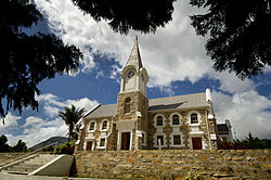
Nederduits Gereformeerde Kerk church in Kareedouw
South Africa Eastern Cape location map.svg
Red pog.svg
Kareedouw
South Africa adm location map.svg
Red pog.svg
Kareedouw
Coordinates: 33°57′7″S24°17′22″E / 33.95194°S 24.28944°E
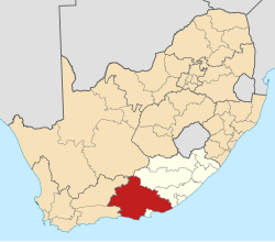
 / -33.95194; 24.28944
Country South Africa
Province Eastern Cape
District Sarah Baartman
Municipality Kou-Kamma
Area
[1]
  Total
15.10 km2 (5.83 sq mi)
Population
 (2011) [1]
  Total
4,985
  Density330/km2 (860/sq mi)
Racial makeup (2011)
[1]
   Black African 32.8%
   Coloured 56.5%
   Indian/Asian 0.3%
   White 9.5%
  Other1.0%
First languages (2011)
[1]
   Afrikaans 72.6%
   Xhosa 22.1%
   English 2.4%
  Other2.9%
Time zone UTC+2 (SAST)
Postal code (street)
6400
PO box
6400
Area code 042

Kareedouw (English: Kareedowns) is a town in the Eastern Cape province of South Africa. It is the administrative centre for the Kou-Kamma Municipality in the Sarah Baartman District of the Eastern Cape.

Contents

History

The town's name derives from the Khoi phrase "karee" meaning "praise". The town was established by white settlers around the year 1750. [2]

Well known Places and Schools in Kareedouw

Schools

Places

Tourism

Kareedouw is the gateway to the Langkloof Mountains; 120 km from Gqeberha. It nestles between the Tsitsikamma and Suuranys Mountains. A popular activity is 4x4 trips through the Suurveld, Kouga and Baviaanskloof Wilderness areas, canoe trips on the Kouga River, and camping and hiking trails. [6] [7] [8] [9]

One important person connected to the town is John Vorster, prime minister of South Africa from 1966 to 1978, who had a house on the coast and is buried in the cemetery next to the

Locations

There is a Kareedouw Peak and a Kareedouw Pass. [11]

The Tsitsikamma mountains are a mountain range located in the Garden Route region of the southern South African coast in the Western Cape and Eastern Cape provinces. They stretch just over 80 km from the Keurbooms River in the west just north of Plettenberg Bay, to Kareedouw Pass in the east. [12] The Formosa Conservation Area is adjacent to the Jagersbos farm, about 15 km west of Kareedouw. [13]

There are medical and pharmaceutical facilities, the provincial B.J. Vorster Hospital, a public library, and a Lutheran Missionary Monument at or near Kareedouw. [14] [15] [16]

References

  1. 1 2 3 4 "Main Place Kareedouw". Census 2011.
  2. "Langkloof Route". Open Africa. 8 July 2002. Retrieved 30 December 2013.
  3. "Paul Sauer High School | In Kareedouw Eastern Cape Hier is elkeen iemand!". www.paulsauer.co.za. Retrieved 24 July 2025.
  4. "Kareedouw Primary School » Contacts & Address". Skools. Archived from the original on 29 May 2017. Retrieved 24 July 2025.
  5. "Norma Jean's Diner, Kareedouw - Restaurant Reviews, Phone Number & Photos - TripAdvisor". www.tripadvisor.co.za. Archived from the original on 6 October 2015. Retrieved 24 July 2025.
  6. "Four Star Hotels in Kareedouw". Essential Travel Info. 31 August 2012. Retrieved 30 December 2013.
  7. "800m2 Land for Sale in Kareedouw | Property EC Jeffreys Bay to Tsitsikamma | Ref: E12444". www.privateproperty.co.za. Archived from the original on 9 September 2012. Retrieved 2 February 2022.
  8. Archived 29 June 2008 at the Wayback Machine
  9. Waddy Lepovitz, H. (1 December 1989). "Gateway to the Mountains: Tourism and Positive Deindustrialization in the Bavarian Alps" . German History. 7 (3): 293–318. doi:10.1177/026635548900700301. ISSN   0266-3554.
  10. "Ghost of apartheid haunts George - PW Botha's town". Anarkismo. Retrieved 30 December 2013.
  11. http://www.aluka.org/action/doBrowse?sa=1&sa=1&br=tax-epithets-derived%7Cnamed-as%7C-no_t-&t=149937&cookieSet=1%5B%5D
  12. "TSITSIKAMMA Mountain Reserve" . Retrieved 30 December 2013.
  13. "Archived copy" (PDF). academic.sun.ac.za. Archived from the original (PDF) on 24 August 2007. Retrieved 12 January 2022.{{cite web}}: CS1 maint: archived copy as title (link)
  14. Archived 12 April 2009 at the Wayback Machine
  15. "Background". Archive.is. 21 April 2006. Archived from the original (PDF) on 11 July 2012. Retrieved 30 December 2013.
  16. "Exploring in the Cacadu district". Archived from the original on 25 January 2008. Retrieved 20 April 2009.