
Fynbos is a small belt of natural shrubland or heathland vegetation located in the Western Cape and Eastern Cape provinces of South Africa. This area is predominantly coastal and mountainous, with a Mediterranean climate and rainy winters. The fynbos ecoregion is within the Mediterranean forests, woodlands, and scrub biome. In fields related to biogeography, fynbos is known for its exceptional degree of biodiversity and endemism, consisting of about 80% species of the Cape floral kingdom, where nearly 6,000 of them are endemic. This land continues to face severe human-caused threats, but due to the many economic uses of the fynbos, conservation efforts are being made to help restore it.

The Karoo is a semi-desert natural region of South Africa. No exact definition of what constitutes the Karoo is available, so its extent is also not precisely defined. The Karoo is partly defined by its topography, geology and climate, and above all, its low rainfall, arid air, cloudless skies, and extremes of heat and cold. The Karoo also hosted a well-preserved ecosystem hundreds of million years ago which is now represented by many fossils.
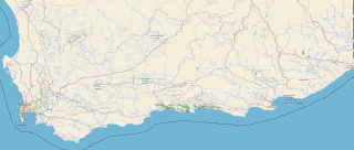
The Garden Route is a 300-kilometre (190 mi) stretch of the south-eastern coast of South Africa which extends from Witsand in the Western Cape to the border of Tsitsikamma Storms River in the Eastern Cape. The name comes from the verdant and ecologically diverse vegetation encountered here and the numerous estuaries and lakes dotted along the coast. It includes towns such as Witsand, Heidelberg, Riversdale, Stilbaai, Albertinia, Gouritsmond, Knysna, Plettenberg Bay, Mossel Bay, Oudtshoorn, Great Brak River, Little Brak River, Wilderness, Sedgefield and Nature's Valley; with George, the Garden Route's largest city and main administrative centre.

George Municipality is a local municipality within the Garden Route District Municipality, in the Western Cape province of South Africa. As of 2011, the population is 193,672. Its municipality code is WC044.

George is the second largest city in the Western Cape province of South Africa. The city is a popular holiday and conference centre, as well as the administrative and commercial hub and the seat of the Garden Route District Municipality. It is named after the British Monarch George III.
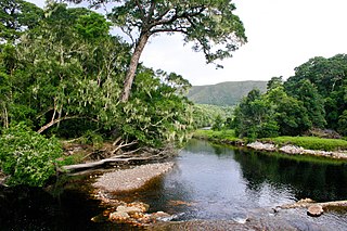
The Knysna–Amatole montane forests ecoregion, of the tropical and subtropical moist broadleaf forests biome, is in South Africa. It covers an Afromontane area of 3,100 square kilometres (1,200 sq mi) in the Eastern Cape and Western Cape provinces.

The Cape Fold Belt is a fold and thrust belt of late Paleozoic age, which affected the sequence of sedimentary rock layers of the Cape Supergroup in the southwestern corner of South Africa. It was originally continuous with the Ventana Mountains near Bahía Blanca in Argentina, the Pensacola Mountains, the Ellsworth Mountains and the Hunter-Bowen orogeny in eastern Australia. The rocks involved are generally sandstones and shales, with the shales persisting in the valley floors while the erosion resistant sandstones form the parallel ranges, the Cape Fold Mountains, which reach a maximum height of 2325 m at Seweweekspoortpiek.

The Tsitsikamma mountains form an east-west mountain range located in the Garden Route region of the southern South African coast in the Western Cape and Eastern Cape provinces. Tsitsikamma means 'place of much water' in the Khoekhoe language.
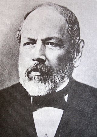
Christian Ferdinand Friedrich Krauss, was a German scientist, traveler and collector.

Kou-Kamma Municipality is a local municipality in South Africa. It is situated in the southwest corner of the Sarah Baartman District Municipality along the Indian Ocean coastline, in the southwestern sector of South Africa's Eastern Cape province. To the west lies the Western Cape. Kou-Kamma also borders the Dr Beyers Naudé Local Municipality in the north and the Kouga Local Municipality to the east. The geographical area of the municipality is 12,540 square kilometres.
The Langkloof is a 160 km-long (99 mi) valley in South Africa, lying between Herold, a small village northeast of George, and The Heights – just beyond Twee Riviere.

The Outeniqua Mountains, named after the Outeniqua Khoikhoi who lived there, is a mountain range that runs a parallel to the southern coast of South Africa, and forms a continuous range with the Langeberg to the west and the Tsitsikamma Mountains to the east. It was known as Serra de Estrella to the Portuguese. The mountains are part of the Garden Route of South Africa.

The R62 is a provincial route in South Africa that connects Ashton with Humansdorp. The R62 runs through the Little Karoo and the Langkloof, passing through Montagu, Ladismith, Calitzdorp, Oudtshoorn, and Joubertina.

Kareedouw is a town in the Eastern Cape province of South Africa. It is the administrative centre for the Kou-Kamma Municipality in the Sarah Baartman District of the Eastern Cape.
Churchill Dam, is a multi-arch type dam located at the Kromme River, near Kareedouw, Eastern Cape, in South Africa. It was established in 1943 and its main purpose is for municipal and industrial usage.
Durbaniella clarki, the Clark's rocksitter, is a butterfly of the family Lycaenidae. It is found in South Africa.
Thestor murrayi, the Murray's skolly, is a butterfly of the family Lycaenidae. It is found in South Africa, where it is known from Name Karoo in the West Cape, from the Swartberg to the Kammanassie, Outeniqua and Tsitsikamma mountains to the Groot Winterhoekberge and Baviaanskloofberge in the East Cape.

Southern Afrotemperate Forest is a kind of tall, shady, multilayered indigenous South African forest. This is the main forest-type in the south-western part of South Africa, naturally extending from the Cape Peninsula in the west, as far as Port Elizabeth in the east. In this range, it usually occurs in small forest pockets, surrounded by fynbos vegetation.
Twee Riviere is a town in Sarah Baartman District Municipality in the Eastern Cape province of South Africa.

Formosa Peak or Peak Formosa is the highest point of the Tsitsikamma Mountains, a coastal range located along the Garden Route in South Africa, and forming part of the Baviaanskloof Mega Reserve.
