
The Province of the Cape of Good Hope, commonly referred to as the Cape Province and colloquially as The Cape, was a province in the Union of South Africa and subsequently the Republic of South Africa. It encompassed the old Cape Colony, as well as Walvis Bay, and had Cape Town as its capital. In 1994, the Cape Province was divided into the new Eastern Cape, Northern Cape and Western Cape provinces, along with part of the North West.

South Africa occupies the southern tip of Africa, its coastline stretching more than 2,850 kilometres from the desert border with Namibia on the Atlantic (western) coast southwards around the tip of Africa and then northeast to the border with Mozambique on the Indian Ocean. The low-lying coastal zone is narrow for much of that distance, soon giving way to a mountainous escarpment that separates the coast from the high inland plateau. In some places, notably the province of KwaZulu-Natal in the east, a greater distance separates the coast from the escarpment. Although much of the country is classified as semi-arid, it has considerable variation in climate as well as topography. The total land area is 1,220,813 km2 (471,359 sq mi). It has the 23rd largest Exclusive Economic Zone of 1,535,538 km2 (592,875 sq mi).

The Orange River is a river in Southern Africa. It is the longest river in South Africa. With a total length of 2,432 km (1,511 mi), the Orange River Basin extends from Lesotho into South Africa and Namibia to the north. It rises in the Drakensberg mountains in Lesotho, flowing westwards through South Africa to the Atlantic Ocean. The river forms part of the international borders between South Africa and Lesotho and between South Africa and Namibia, as well as several provincial borders within South Africa. Except for Upington, it does not pass through any major cities. The Orange River plays an important role in the South African economy by providing water for irrigation and hydroelectric power. The river was named the Orange River in honour of the Dutch ruling family, the House of Orange, by the Dutch explorer Robert Jacob Gordon. Other names include simply the word for river, in Khoekhoegowab orthography written as !Garib, which is rendered in Afrikaans as Gariep River with the intrusion of a velar fricative in place of the alveolar click, Groote River or Senqu River, derived from ǂNū "Black". It is known in isiZulu as isAngqu

The N1 is a national route in South Africa that runs from Cape Town through Bloemfontein, Johannesburg, Pretoria and Polokwane to Beit Bridge on the border with Zimbabwe. It forms the first section of the famed Cape to Cairo Road.

The Great Fish River is a river running 644 kilometres (400 mi) through the South African province of the Eastern Cape. The coastal area between Port Elizabeth and the Fish River mouth is known as the Sunshine Coast. The Great Fish River was originally named Rio do Infante, after João Infante, the captain of one of the caravels of Bartolomeu Dias. Infante visited the river in the late 1480s.

Gamtoos River or Gamptoos River is a river in the Eastern Cape Province, South Africa. It is formed by the confluence of the Kouga River and the Groot River and is approximately 645-kilometre (401 mi) long with a catchment area of 34,635 square kilometres (13,373 sq mi).

Port Elizabeth, officially renamed Gqeberha and colloquially often referred to as P.E., is a major seaport and the most populous city in the Eastern Cape province of South Africa. It is the seat of the Nelson Mandela Bay Metropolitan Municipality, South Africa's second-largest metropolitan district by area size. It is the sixth-most-populous city in South Africa and is the cultural, economic and financial centre of the Eastern Cape.
Kuils River is a town in the Western Cape, South Africa, 25 km east of Cape Town CBD at the gateway of the Cape Winelands. It is also the name of the main tributary of the Eerste River.
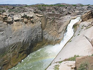
Augrabies Falls National Park is a national park located around the Augrabies Falls, about 120 km west of Upington in the Northern Cape Province, South Africa. It was established in 1966.

The Tsitsikamma National Park is a protected area on the Garden Route, Western Cape and Eastern Cape, South Africa. It is a coastal reserve well known for its indigenous forests, dramatic coastline, and the Otter Trail. On 6 March 2009 it was amalgamated with the Wilderness National Park and various other areas of land to form the Garden Route National Park.

The Cape Fold Belt is a fold and thrust belt of late Paleozoic age, which affected the sequence of sedimentary rock layers of the Cape Supergroup in the southwestern corner of South Africa. It was originally continuous with the Ventana Mountains near Bahía Blanca in Argentina, the Pensacola Mountains, the Ellsworth Mountains and the Hunter-Bowen orogeny in eastern Australia. The rocks involved are generally sandstones and shales, with the shales persisting in the valley floors while the erosion resistant sandstones form the parallel ranges, the Cape Fold Mountains, which reach a maximum height of 2325 m at Seweweekspoortpiek.
Eerste River is a town in the Western Cape, South Africa and a suburb of the City of Cape Town. It forms part of the Oostenberg subregion of the city situated behind the Stellenbosch/Vlaeberg Hills on the eastern outskirts of the city..
Boknesstrand is a small seaside town in the Eastern Cape of South Africa. It is close to Cannon Rocks, Kenton-on-Sea, Alexandria, Bushman's River Mouth and Port Alfred. It is part of the Ndlambe Local Municipality in the Sarah Baartman District of the Eastern Cape.
Porterville is a town in the Western Cape province of South Africa.

The Groot River is a river in the southern area of the Eastern Cape province of South Africa. It is a right hand tributary of the Gamtoos River. This river passes through Steytlerville.

Infanta is a settlement in Overberg District Municipality in the Western Cape province of South Africa.

De Doorns is a town in the Breede Valley Local Municipality, Cape Winelands District Municipality in the Western Cape province of South Africa.
Mhlangeni is a settlement in Amathole District Municipality in the Eastern Cape province of South Africa.

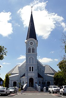
Dr Beyers Naudé Local Municipality is a new local municipality that was established by merging the Camdeboo, Ikwezi and Baviaans local municipalities in the Sarah Baartman District of the Eastern Cape in South Africa. The decision to merge the municipalities was taken by the Municipal Demarcation Board in 2015 but only took effect after municipal elections on 3 August 2016. The new municipality is named after the Afrikaner cleric and anti-apartheid activist Beyers Naudé. Its seat is in Graaff-Reinet.


