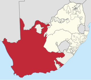
The Province of the Cape of Good Hope, commonly referred to as the Cape Province and colloquially as The Cape, was a province in the Union of South Africa and subsequently the Republic of South Africa. It encompassed the old Cape Colony, as well as Walvis Bay, and had Cape Town as its capital. In 1994, the Cape Province was divided into the new Eastern Cape, Northern Cape and Western Cape provinces, along with part of the North West.

The Karoo is a semi-desert natural region of South Africa. No exact definition of what constitutes the Karoo is available, so its extent is also not precisely defined. The Karoo is partly defined by its topography, geology and climate, and above all, its low rainfall, arid air, cloudless skies, and extremes of heat and cold. The Karoo also hosted a well-preserved ecosystem hundreds of million years ago which is now represented by many fossils.
Delmas is a small maize farming town situated east of Johannesburg in Mpumalanga, South Africa. The town is located some 19 km north-east of Springs and 73 km south-east of Pretoria.
Mookgophong, also known as Naboomspruit, is a town in the Limpopo province of South Africa. The town is located approximately 42 km north-east of Modimolle and 51 km south-west of Mokopane.

Zeerust is a commercial town situated in the Ngaka Modiri Molema district of North West Province, South Africa. It lies in the Marico valley, approximately 240 kilometres northwest of Johannesburg. It lies on the N4, the main road link between South Africa and Botswana. There are large cattle ranches in the area, as well as wheat, maize, tobacco and citrus fruit farms. There are also fluorite and chromite mines in the vicinity. Tourism is also a developing industry.
Koster is a small farming town situated on the watershed between the Orange and Limpopo Rivers in North West Province of South Africa.
The R332 is a Regional Route in South Africa that connects Willowmore with the R330 and the N2 near Humansdorp.
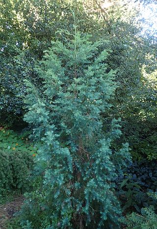
Widdringtonia schwarzii is a species of Widdringtonia native to South Africa, where it is endemic to the Baviaanskloof and Kouga Mountains west of Port Elizabeth in Eastern Cape Province; it occurs on dry rocky slopes and crags at 600–1,200 m altitude. It is threatened by habitat loss, particularly by wildfire. The Willowmore cypress is a protected tree in South Africa.
Johann Fran(t)z Drège, commonly referred to by his standard botanical author abbreviation Drège, was a German horticulturalist, botanical collector and explorer of Huguenot descent.

Heideveld is a town or suburb in the Athlone part of Cape Town, South Africa. Heideveld got its name because the area used to have large grazing grounds where a popular flower ("heideblommetjie") grew in abundance. The area used to be a dairy farm, and cows used to graze amongst the heideblommetjies.

The N9 is a national route in South Africa that connects George with the N1 at Colesberg, via Graaff-Reinet and Middelburg.

Strydenburg is a town in the east of the Northern Cape province in South Africa. Seventy-seven km north of Britstown, it was laid out by the Dutch Reformed Church on the farm Roodepan in 1892. It also lies on the N12, which separates the actual town from its township.
Bothasig is a suburban area of the City of Cape Town in Western Cape, South Africa. It is located north of Edgemead and east of Milnerton. It is located approximately 15 km north-east of the Cape Town city centre.

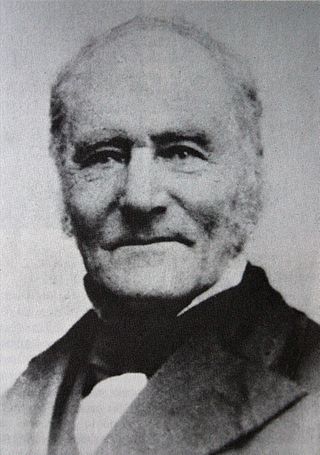
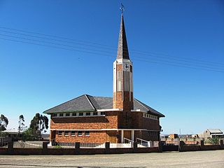
Steytlerville is a settlement on the R329 route in Sarah Baartman District Municipality in the Eastern Cape province of South Africa. The town is situated on the right bank of the Groot River, where the river emerges from a valley in the Grootrivierberge at Noorspoort. It is 164 km north-west of Port Elizabeth and 90km east of Willowmore. It was founded in 1876 on the farm Noorspoort and attained municipal status in 1891. It is named after Reverend Abraham Isaac Steytler (1840-1922), a minister of the Dutch Reformed Church and Moderator of the Cape synod from 1909 to 1915.
Willowvale is a town in Amathole District Municipality in the Eastern Cape province of South Africa.
Oberholzer is a town in West Rand District Municipality in the Gauteng province of South Africa. The town is 85 km south-west of Johannesburg, just north-west of Carletonville.

Elsburg is a town in Ekurhuleni in the Gauteng province of South Africa. It is a town some 6 km south-east of Germiston.
Rietbron is a town in Sarah Baartman District Municipality in the Eastern Cape province of South Africa. It is on the R306 road.

Klein Karoo Commando was a light infantry regiment of the South African Army. It formed part of the South African Army Infantry Formation as well as the South African Territorial Reserve.
Pieter Mey is a South African politician and former police lieutenant. He has been serving as a Member of the National Assembly of South Africa for the Freedom Front Plus since May 2019. Mey is also the Eastern Cape provincial leader of the FF Plus.


