Sarah Baartman old: Cacadu | |
---|---|
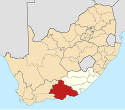
![]() Location in the Eastern Cape | |
Coordinates: 33°57′S25°36′E / 33.950°S 25.600°E | |
Country | South Africa |
Province | Eastern Cape |
District | Sarah Baartman District Municipality |
Seat | Gqeberha |
Local municipalities | |
Government | |
• Type | Municipal council |
• Mayor | Khunjuzwa Eunice Kekana (ANC) |
Area | |
• Total | 58,194 km2 (22,469 sq mi) |
Population (2011) [2] | |
• Total | 450,584 |
• Density | 7.7/km2 (20/sq mi) |
Racial makeup (2011) | |
• African | 53.3% |
• Coloured | 34.9% |
• Indian/Asian | 0.3% |
• White | 10.9% |
First languages (2011) | |
• Xhosa | 45.4% |
• Afrikaans | 45.1% |
• English | 6.5% |
• Other | 3% |
Time zone | UTC+2 (SAST) |
Municipal code | DC10 |
The Sarah Baartman District Municipality (Xhosa : uMasipala weSithili sase Sarah Baartman; Afrikaans : Sarah Baartman-distriksmunisipaliteit), formerly the Cacadu District Municipality, is situated in the western part of the Eastern Cape province of South Africa, covering an area of 58,242 square kilometres. The area of the district municipality includes seven local municipalities. The seat is the city of Gqeberha, although Gqeberha is not itself in the district (it is in the Nelson Mandela Bay Metropolitan Municipality). As of 2011, the languages most spoken among the 388,201 inhabitants were Xhosa and Afrikaans. The district code is DC10.
The municipality is a multi-ethnic administration, formed through the merging of the predominantly Afrikaans-speaking western part of the Eastern Cape, together with Xhosa areas near the Fish River, and the English district of Albany (with its own distinctive local culture, dating back to the 1820 settlers).
The name Cacadu is regarded by the Xhosa as covering the entire area of the district municipality, but in fact it is taken from a river that runs entirely in Gqeberha. Cacadu, meaning "bulrush water", is the Xhosa form of the Khoekhoe name of the river. The Dutch name is a translation: Papenkuils (in Afrikaans a bulrush is called a papkuil). The river rises in the Parsons Vlei and runs to the sea close to the Gqeberha industrial suburb of Deal Party.
In 2015, the municipality was renamed for Saartjie "Sarah" Baartman (1789–1815), a Khoekhoe woman who was taken to London to perform at freak shows and after her death her remains were exhibited until 1974. The renaming is part of an effort to redress marginalisation of the Khoekhoe people. [3]
The Executive Mayor of Sarah Baartman District Municipality is Khunjuzwa Eunice Kekana, and the Municipal Manager is Ted Pillay.
The Sarah Baartman district covers an area of 58,243 square kilometres (22,488 sq mi) in the southwestern part of the Eastern Cape province. It extends to the Great Fish River in the east and the Sneeuberge in the north. The metropolitan area around Gqeberha is excluded from the district, being in the Nelson Mandela Bay Metropolitan Municipality.
The southwestern part of the district (west of Gqeberha) is marked by several ranges of mountains that run parallel to the sea, including the Baviaanskloof mountains, the Kouga mountains and the Tsitsikamma mountains. In the southeastern part (east of Port Elizabeth) is the Albany region around the city of Grahamstown. The northern interior of the district is the southeastern end of the Karoo.
To the west the district borders on the Garden Route and Central Karoo districts of the Western Cape; to the north it borders on the Pixley ka Seme district of the Northern Cape; and to the east it borders on the Chris Hani and Amathole districts of the Eastern Cape.
Sarah Baartman district is divided into nine local municipalities, as below:
Name | Seat | Population (2011) | Area (km2) | Density (inhabitants/km2) |
---|---|---|---|---|
Blue Crane Route Local Municipality | Somerset East | 36,002 | 11,068 | 3.3 |
Dr Beyers Naudé Local Municipality | Graaff-Reinet | 79,291 | 28,653 | 2.8 |
Makana Local Municipality | Grahamstown | 80,390 | 4,376 | 18.4 |
Ndlambe Local Municipality | Port Alfred | 61,176 | 1,841 | 33.2 |
Sundays River Valley Local Municipality | Kirkwood | 54,504 | 5,994 | 9.1 |
Kouga Local Municipality | Jeffreys Bay | 98,558 | 2,670 | 36.9 |
Kou-Kamma Local Municipality | Kareedouw | 40,663 | 3,642 | 11.2 |
Total | 450,584 | 58,243 | 7.7 |
After the municipal elections on 3 August 2016, the Camdeboo, Ikwezi and Baviaans municipalities were merged to form the new Dr Beyers Naudé Local Municipality, with its head offices in Graaff-Reinet. This merger resulted in there being seven local municipalities within the Sarah Baartman District.
The following statistics are from the 2001 census.
Language | Population | % |
---|---|---|
Xhosa | 190,003 | 48.94% |
Afrikaans | 174,917 | 45.06% |
English | 20 806 | 5.36% |
Sotho | 744 | 0.19% |
Zulu | 596 | 0.15% |
Other | 451 | 0.12% |
Ndebele | 192 | 0.05% |
Swati | 172 | 0.04% |
Tswana | 127 | 0.03% |
Northern Sotho | 87 | 0.02% |
Tsonga | 80 | 0.02% |
Venda | 46 | 0.01% |
Gender | Population | % |
---|---|---|
Female | 202,295 | 52.11% |
Male | 185,906 | 47.89% |
Ethnic group | Population | % |
---|---|---|
Black African | 202,289 | 52.11% |
Coloured | 141,083 | 36.34% |
White | 44 110 | 11.36% |
Indian/Asian | 719 | 0.19% |
Age | Population | % |
---|---|---|
0–4 | 33 178 | 8.55% |
5–9 | 36 745 | 9.47% |
10–14 | 40 809 | 10.51% |
15–19 | 41 052 | 10.57% |
20–24 | 33 222 | 8.56% |
25–29 | 32 096 | 8.27% |
30–34 | 29 929 | 7.71% |
35–39 | 27 840 | 7.17% |
40–44 | 24 208 | 6.24% |
45–49 | 20 483 | 5.28% |
50–54 | 16 494 | 4.25% |
55–59 | 13 289 | 3.42% |
60-64 | 12 928 | 3.33% |
65–69 | 9 218 | 2.37% |
70–74 | 6 764 | 1.74% |
75–79 | 4 447 | 1.15% |
80–84 | 3 276 | 0.84% |
85–89 | 1 325 | 0.34% |
90–94 | 680 | 0.18% |
95–99 | 154 | 0.04% |
100 plus | 64 | 0.02% |
Election results for Cacadu in the South African general election, 2004.
Party | Votes | % |
---|---|---|
African National Congress | 116,320 | 72.07% |
Democratic Alliance | 27 615 | 17.11% |
Independent Democrats | 3 768 | 2.33% |
New National Party | 3 694 | 2.29% |
African Christian Democratic Party | 2 755 | 1.71% |
United Democratic Movement | 2 416 | 1.50% |
Freedom Front Plus | 1 687 | 1.05% |
Pan African Congress | 999 | 0.62% |
Azanian People's Organisation | 492 | 0.30% |
Inkhata Freedom Party | 277 | 0.17% |
United Christian Democratic Party | 222 | 0.14% |
NA | 201 | 0.12% |
Socialist Party of Azania | 168 | 0.10% |
EMSA | 160 | 0.10% |
Christian Democratic Party | 144 | 0.09% |
Peace and Justice Congress | 113 | 0.07% |
UF | 99 | 0.06% |
TOP | 82 | 0.05% |
Keep It Straight and Simple Party | 75 | 0.05% |
New Labour Party | 69 | 0.04% |
Minority Front | 43 | 0.03% |
Total | 161,399 | 100.00% |
The Eastern Cape is one of the nine provinces of South Africa. Its capital is Bhisho, and its largest city is Gqeberha. Due to its climate and nineteenth-century towns, it is a common location for tourists. It is also known for having been home to many anti-apartheid activists, including Nelson Mandela.
The Northern Cape is the largest and most sparsely populated province of South Africa. It was created in 1994 when the Cape Province was split up. Its capital is Kimberley. It includes the Kalahari Gemsbok National Park, part of the Kgalagadi Transfrontier Park and an international park shared with Botswana. It also includes the Augrabies Falls and the diamond mining regions in Kimberley and Alexander Bay.
George Municipality is a local municipality within the Garden Route District Municipality, in the Western Cape province of South Africa. As of 2011, the population is 193,672. Its municipality code is WC044.
Beaufort West Municipality is a local municipality located in the Western Cape province of South Africa. As of 2011, the population is 49,586. Its municipality code is WC053.
The Cape Winelands District Municipality, formerly the Boland District Municipality, is a district municipality located in the Boland region of the Western Cape province of South Africa. As of 2011, it had a population of 787,490. The largest towns in the municipality are Paarl, Worcester, Stellenbosch and Wellington.
Breede Valley Municipality is a local municipality located within the Cape Winelands District Municipality, in the Western Cape province of South Africa. As of 2007, it had a population of 166,825. Its municipality code is WC025.
Albany, South Africa was a district in the Eastern Cape, South Africa. Grahamstown was traditionally the administrative capital, cultural centre and largest town of the Albany district.
The Nelson Mandela Bay Municipality is one of eight metropolitan municipalities in South Africa. It is located on the shores of Algoa Bay in the Eastern Cape province and comprises the city of Gqeberha, the nearby towns of Uitenhage and Despatch, and the surrounding rural area.
The R75 is a provincial route in Eastern Cape, South Africa that connects Graaff-Reinet with Gqeberha via Despatch, Kariega and Jansenville.
Gqeberha, formerly known as Port Elizabeth and colloquially referred to as P.E., is a major seaport and the most populous city in the Eastern Cape province of South Africa. It is the seat of the Nelson Mandela Bay Metropolitan Municipality, South Africa's second-smallest metropolitan municipality by area. It is the sixth-most populous city in South Africa and is the cultural, economic and financial hub of the Eastern Cape.
Kenton-on-Sea, more commonly known as Kenton, is a small coastal town on the Sunshine Coast, in the Eastern Cape of South Africa. It is situated between the Bushmans and the Kariega Rivers, and lies approximately halfway between the industrial centres of East London and Gqeberha. Kenton is part of the Ndlambe Local Municipality in the Sarah Baartman District Municipality of the Eastern Cape.
Ndlambe Municipality is a local municipality within the Sarah Baartman District Municipality, in the Eastern Cape of South Africa. Its capital is Port Alfred. It is a predominantly rural area with agriculture and tourism dominating the economy.
The Amathole District Municipality is one of the 7 districts of the Eastern Cape province of South Africa. The seat is East London. As of 2011, over 90% of its 892,637 inhabitants spoke isiXhosa. The district code is DC12. Amathole means "calves", the name of the mountain range and forest which forms the northern boundary of the district.
Kou-Kamma Municipality is a local municipality in South Africa. It is situated in the southwest corner of the Sarah Baartman District Municipality along the Indian Ocean coastline, in the southwestern sector of South Africa's Eastern Cape province. To the west lies the Western Cape. Kou-Kamma also borders the Dr Beyers Naudé Local Municipality in the north and the Kouga Local Municipality to the east. The geographical area of the municipality is 12,540 square kilometres.
Kareedouw is a town in the Eastern Cape province of South Africa. It is the administrative centre for the Kou-Kamma Municipality in the Sarah Baartman District of the Eastern Cape.
Karoo Hoogland Municipality is a local municipality within the Namakwa District Municipality, in the Northern Cape province of South Africa. The municipality incorporates the towns of Williston, Fraserburg and Sutherland. Although the towns are separated by more than 100 km by road, they share many administrative tasks.
In the colonial history of South Africa, the Glen Grey Act was an 1894 Act of the Parliament of the Cape Colony. Instigated by the government of Prime Minister Cecil John Rhodes, it established a system of individual land tenure and created a labour tax to force Xhosa men into employment on commercial farms or in industry. The act was so named because, although it was later extended to a larger area, it initially applied only in the Glen Grey district, a former name for the area around Lady Frere, east of Queenstown, in the Eastern Cape province of South Africa.
Blue Crane Route Municipality is a local municipality within the Sarah Baartman District Municipality, in the Eastern Cape of South Africa. The municipality is named after the South African national bird, the blue crane.
Pearston is a small town in the eastern Karoo, in the Eastern Cape province of South Africa. It lies between Graaff-Reinet and Somerset East at the foot of the Coetzeesberge, about 160 kilometres (100 mi) north of Port Elizabeth. It falls within the Blue Crane Route Local Municipality and has a population of approximately 4,500 people.
Dr Beyers Naudé Municipality is a local municipality within the Sarah Baartman District Municipality, in the Eastern Cape of South Africa. The municipality was established by merging the Camdeboo, Ikwezi and Baviaans local municipalities. The decision to merge the municipalities was taken by the Municipal Demarcation Board in 2015 but only took effect after municipal elections on 3 August 2016. The new municipality is named after the Afrikaner cleric and anti-apartheid activist Beyers Naudé. Its seat is in Graaff-Reinet. The merger was motivated by political interests because the ruling party, the African National Congress, was losing support in the area. One of the municipalities, Baviaans, was already governed by the opposition Democratic Alliance.