
The Eastern Cape is one of the nine provinces of South Africa. Its capital is Bhisho, and its largest city is Gqeberha. Due to its climate and nineteenth-century towns, it is a common location for tourists. It is also known for being home to many anti-apartheid activists, including Nelson Mandela.

The Sotho, also known as the Basotho, are a Sotho-Tswana ethnic group native to Southern Africa. They primarily inhabit the regions of Lesotho and South Africa.

Chris Hani, born Martin Thembisile Hani, was the leader of the South African Communist Party and chief of staff of uMkhonto we Sizwe, the armed wing of the African National Congress (ANC). He was a fierce opponent of the apartheid government, and was assassinated by Janusz Waluś, a Polish immigrant and sympathiser of the Conservative opposition on 10 April 1993, during the unrest preceding the transition to democracy.

The Great Kei River is a river in the Eastern Cape province of South Africa. It is formed by the confluence of the Black Kei River and White Kei River, northeast of Cathcart. It flows for 320 km (199 mi) and ends in the Great Kei Estuary at the Indian Ocean with the small town Kei Mouth on the west bank. Historically the Great Kei River formed the southwestern border of the Transkei region as was formerly known as the Nciba River.
The Sarah Baartman District Municipality, formerly the Cacadu District Municipality, is situated in the western part of the Eastern Cape province of South Africa, covering an area of 58,242 square kilometres. The area of the district municipality includes seven local municipalities. The seat is the city of Gqeberha, although Gqeberha is not itself in the district. As of 2011, the languages most spoken among the 388,201 inhabitants were Xhosa and Afrikaans. The district code is DC10.
Ngcobo, alternatively rendered Engcobo, is a town in the Eastern Cape province of South Africa.

Tarkastad is a Karoo semi-urban settlement situated on the banks of Tarka River in the Eastern Cape province of South Africa. Tarkastad is on a plain to the north of the Winterberg mountain range on the R61 between Cradock and Komani and only three hours from Gqeberha. The name Tarkastad is believed to come from the Khoi-Khoi word Traka or the Celtic word Tarka and the Afrikaans word Stad. The fact that the town is overlooked by Martha and Mary; two peaks which look like two women resting after a hard day's work, also lends to the name.
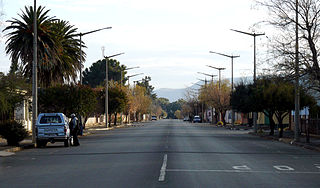
Whittlesea is a semi-rural town situated on the R67 road in the Hewu district, 37 km south of Komani, Eastern Cape Province, South Africa. The town is made up of the townships Ekuphumleni, Bhede, Ndlambe, Extension 4, Extension 5 and Sada. The town falls under the Enoch Mgijima Local Municipality which is under the Chris Hani District Municipality. Surrounding Whittlesea are 36 villages which make up the Hewu district.

Intsika Yethu Municipality is a local municipality within the Chris Hani District Municipality, in the Eastern Cape province of South Africa. The municipality is one of the six local municipality in this district. Intsika Yethu is an isiXhosa word meaning "our pillars".

Maletswai Local Municipality was an administrative area in the Joe Gqabi District of the Eastern Cape in South Africa. The municipality was merged with Gariep Local Municipality immediately after the August 2016 Local Municipal Elections to form the new Walter Sisulu Local Municipality.

Inkwanca Local Municipality was a local municipality that forms part of the Chris Hani District Municipality in the Eastern Cape province of South Africa. Inkwanca is an isiXhosa name meaning cold. The municipal area is the coldest area in the country and the lowest temperatures are recorded in the area every year. After municipal elections on 3 August 2016 it was merged into the larger Enoch Mgijima Local Municipality.

Tsolwana Local Municipality was an administrative area in the Chris Hani District of the Eastern Cape in South Africa. Tsolwana is an isiXhosa name which means "something with a sharp ending or a tip", referring the mountains around the whole area. After municipal elections on 3 August 2016 it was merged into the larger Enoch Mgijima Local Municipality.

Dr AB Xuma Local Municipality is a local municipality within the Chris Hani District Municipality, in the Eastern Cape province of South Africa. Ngcobo is an isiXhosa word for a sweet grass found in the area.
Sterkstroom is a settlement in Enoch Mgijima Local Municipality of the Chris Hani District in the Eastern Cape province of South Africa.
Cala is a town in Sakhisizwe Local Municipality, part of the Chris Hani District Municipality in the Eastern Cape province of South Africa.
Molteno Hospital is a Provincial government funded hospital for the Enoch Mgijima Local Municipality area in Molteno, Eastern Cape in South Africa.
The Eastern Cape province of South Africa is governed in a parliamentary system in which the people elect the provincial legislature and the legislature, in turn, elects the Premier as head of the executive. The Premier leads an Executive Council consisting of members who oversee various executive departments. The structure of the provincial government is defined by chapter six of the Constitution of South Africa.

Thornhill is a rural village in Enoch Mgijima Local Municipality under the Chris Hani District Municipality in the Eastern Cape province of South Africa. Under the previous political dispensation it fell in the Ciskei homeland.

Enoch Mgijima Municipality is a local municipality within the Chris Hani District Municipality, in the Eastern Cape province of South Africa. It was established after the August 2016 local elections by merging the Tsolwana, Inkwanca, and Lukhanji local municipalities.
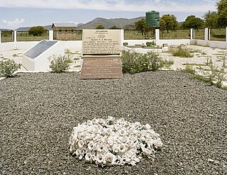
In the Bulhoek massacre, a white police force from the Union of South Africa killed 163 Xhosa civilians. The massacre occurred on 24 May 1921, in the village of Ntabelanga in the Cape Province. After a dispute over land in Ntabelanga, dating back to 1920, an 800-strong police force from the Union of South Africa led by Colonel Johan Davey and General Koos van der Venter gathered at Ingxingwa Ye Nkunzini, in the Bulhoek valley, and Ingxingwa ka Stivini, Steven's Valley. At the same time 500 men known as the "Israelites", armed with spears and knobkerries, and led by Enoch Mgijima, gathered in an open field, ready to defend their families and community. After failed final negotiations between the two parties, a battle ensued. The 20-minute battle, which left an estimated 163 Israelites dead, 129 wounded and 95 taken as prisoners, became known as the Bulhoek Massacre.


