
Bronkhorstspruit is a town 50 km east of Pretoria, Gauteng, South Africa along the N4 highway towards eMalahleni. It also includes three townships called Zithobeni, Rethabiseng and Ekangala. On 18 May 2011, the Tshwane Metropolitan Municipality took over the municipal administration from the abolished Kungwini Local Municipality, which makes Bronkhorstspruit part of Tshwane.
Westonaria is a town in the west of Gauteng province of South Africa. It is situated in the Rand West City Local Municipality, part of the West Rand District Municipality. During the apartheid era, Africans lived outside town in Bekkersdal. The town is some 45 km west of Johannesburg and 18 km south of Randfontein.

Ermelo is the educational, industrial and commercial town of the 7,750 km2 Gert Sibande District Municipality in Mpumalanga province, Republic of South Africa. It is both a mixed agriculture and mining region. It is located 210 km east of Johannesburg.
Mookgophong, formerly known as Naboomspruit, is a town in the Limpopo province of South Africa. The town is located approximately 42 km north-east of Modimolle and 51 km south-west of Mokopane.

The Great Kei River is a river in the Eastern Cape province of South Africa. It is formed by the confluence of the Black Kei River and White Kei River, northeast of Cathcart. It flows for 320 km (199 mi) and ends in the Great Kei Estuary at the Indian Ocean with the small town Kei Mouth on the west bank. Historically the Great Kei River formed the southwestern border of the Transkei region as was formerly known as the Nciba River.

The R61 is a long provincial route in South Africa that connects Beaufort West with Port Shepstone via Graaff-Reinet, Komani, Mthatha and Port Edward.
The amaMfengu were a group of Xhosa clans whose ancestors were refugees that fled from the Mfecane in the early-mid 19th century to seek land and protection from the Xhosa. These refugees were assimilated into the Xhosa nation and were officially recognized by the then king, Hintsa.
Ndabeni is an industrial suburb of Cape Town, South Africa, mainly occupied by light industries such as textiles and clothing. It is located about 6 km east of Cape Town city centre and is serviced by a railway station. Ndabeni is bordered to the south east by Pinelands and to the north by Maitland. Its postcode is 7405.
Ngcobo, alternatively rendered Engcobo, is a town in the Eastern Cape province of South Africa.

The Tsomo River copper or Tsomo River opal is a species of butterfly in the family Lycaenidae. It is endemic to South Africa, where it is found from the northern Eastern Cape to southern KwaZulu-Natal.
Porterville is a town in the Western Cape province of South Africa.

Prieska is a town on the south bank of the Orange River, in the province of the Northern Cape, in western South Africa. It is located on the southern bank of the Orange River, 130 km north-west of Britstown and 75 km south-east of Marydale.
Ncora Dam is a gravity type dam built by Concor and located on the Tsomo River, near Tsomo, Eastern Cape, South Africa. It was established in 1972 and serves mainly for irrigation purposes. The hazard potential of the dam has been ranked high (3).
Harpendyreus tsomo, the Tsomo blue, is a butterfly of the family Lycaenidae. It is mainly found in Lesotho, but also in South Africa where it is known from high altitudes in the Orange Free State and the East Cape.
Bothasig is a suburban area of the City of Cape Town in Western Cape, South Africa. It is located north of Edgemead and east of Milnerton. It is located approximately 15 km north-east of the Cape Town city centre.
Cala is a town in Sakhisizwe Local Municipality, part of the Chris Hani District Municipality in the Eastern Cape province of South Africa.
The Tsomo River is a river in the Eastern Cape Province of South Africa. It is a tributary of the Great Kei River.
Faure is a hamlet some 16 km south-west of Stellenbosch and 13 km north-west of Strand. Administratively it is a suburb of the City of Cape Town, and is in the Helderberg region. Nearby is the kramat or tomb of Sheik Yusuf (1626-1699), an Islamic expatriate priest. Faure is a common surname; it is uncertain after whom this place was named. It may have been named after Pieter Faure, the name of South Africa's first trawler which arrived in Table Bay in 1897.

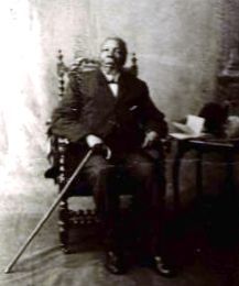
John Knox Bokwe was a South African journalist, Presbyterian minister and one of the most celebrated Xhosa hymn writers and musician. He is best known for his compositions Vuka Deborah, Plea for Africa, and Marriage Song.
The R409 is a Regional Route in South Africa. Its northern terminus is the R61 between Cofimvaba and Ngcobo. It heads south-east to Tsomo where it meets with the eastern terminus of the R352. From Tsomo, it continues south-east, through Nqamakwe to the N2 at Ndabakazi. It is cosigned with the N2 for 12 km east to Butterworth. From Butterworth, it heads south-east again to Kentani, where it reaches its southern terminus at the R349.


