
Ciskei, officially the Republic of Ciskei, was a Bantustan for the Xhosa people, located in the southeast of South Africa. It covered an area of 7,700 square kilometres (3,000 sq mi), almost entirely surrounded by what was then the Cape Province, and possessed a small coastline along the shore of the Indian Ocean.

Stellenbosch Municipality is the local municipality that governs the towns of Stellenbosch, Franschhoek and Pniel, and the surrounding rural areas, in the Western Cape province of South Africa. It covers an area of 831 square kilometres (321 sq mi), and as of 2022 had a population of 175,411 people. It falls within the Cape Winelands District Municipality.

The Great Kei River is a river in the Eastern Cape province of South Africa. It is formed by the confluence of the Black Kei River and White Kei River, northeast of Cathcart. It flows for 320 km (199 mi) and ends in the Great Kei Estuary at the Indian Ocean with the small town Kei Mouth on the west bank. Historically the Great Kei River formed the southwestern border of the Transkei region as was formerly known as the Nciba River.
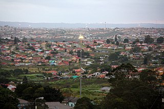
Mdantsane is a South African urban township situated 15 km away from East London and 37 km away from Qonce in the Eastern Cape. It is the second largest township in Eastern Cape and 17th largest in the Top 20 largest townships in South Africa.

Bonvillars is a municipality in the district of Jura-Nord Vaudois in the canton of Vaud in Switzerland.
Palézieux is a village and former municipality in the district of Lavaux-Oron in the canton of Vaud in Switzerland. Since 2012 it forms part of the municipality of Oron.

The Chris Hani District Municipality is a landlocked district municipality situated in the centre of the Eastern Cape province of South Africa and is made up of eight local municipalities. Most of the communities are in rural areas. The landscape ranges from moist uplands and grassland hills to the arid Karoo scrubland.

Tarkastad is a Karoo semi-urban settlement situated on the banks of Tarka River in the Eastern Cape province of South Africa. Tarkastad is on a plain to the north of the Winterberg mountain range on the R61 between Cradock and Komani and only three hours from Gqeberha. The name Tarkastad is believed to come from the Khoi-Khoi word Traka or the Celtic word Tarka and the Afrikaans word Stad. The fact that the town is overlooked by Martha and Mary; two peaks which look like two women resting after a hard day's work, also lends to the name.
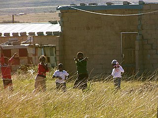
Whittlesea is a semi-rural town situated on the R67 road in the Hewu district, 37 km south of Komani, Eastern Cape Province, South Africa. The town is made up of the townships Ekuphumleni, Bhede, Ndlambe, Extension 4, Extension 5 and Sada. The town falls under the Enoch Mgijima Local Municipality which is under the Chris Hani District Municipality. Surrounding Whittlesea are 36 villages which make up the Hewu district.
Dimbaza is a township in the Eastern Cape province of South Africa, located in the Buffalo City Metropolitan Municipality, 20 kilometres (12 mi) northwest of King William's Town on the R63 road to Alice and Fort Beaufort. As of 2011, it had a population of 21,783.
Tsolwana Nature Reserve is an 8,500 hectare nature reserve situated on the edge of the Winterberg Mountain range. It is located 60 km west of Queenstown, and 30 km south- east of Tarkastad in Eastern Cape Province, South Africa and is managed by Eastern Cape Parks Board. Its western boundary is formed by the upper Black Kei River. The reserve's name originates from the Xhosa word for "spike", due to the presence of the cone-shaped hill, Spitskop.

Saldanha, also known as Saldanha Bay, is a town of 21,636 people, located 110 kilometres (70 mi) north of Cape Town on the northern shore of Saldanha Bay, in the Western Cape province of South Africa. Its situation as a natural sheltered harbour has led to development as a port for the export of iron ore from Sishen in the Northern Cape, which is transported on the Sishen–Saldanha railway line. The port is one of the largest exporting ports of ore in the whole of Africa, and it is able to handle ships as large as 200 000 tons deadweight.
The Rural Municipality of Mountain View No. 318 is a rural municipality (RM) in the Canadian province of Saskatchewan within Census Division No. 12 and SARM Division No. 6.

Inkwanca Local Municipality was a local municipality that forms part of the Chris Hani District Municipality in the Eastern Cape province of South Africa. Inkwanca is an isiXhosa name meaning cold. The municipal area is the coldest area in the country and the lowest temperatures are recorded in the area every year. After municipal elections on 3 August 2016 it was merged into the larger Enoch Mgijima Local Municipality.
Sterkstroom is a settlement in Enoch Mgijima Local Municipality of the Chris Hani District in the Eastern Cape province of South Africa.
Lesseyton is a town in Enoch Mgijima Local Municipality in the Eastern Cape province of South Africa, located 14 km (8.7 mi) northwest of Queenstown. Almost all residents are Xhosa speakers. Lesseyton has two schools: Lesseyton Primary School and Ndlovukazi Public High School.
Sada is a semi-rural settlement, situated 3 km away from Whittlesea, 30 km north of Seymour and 40 km south of Queenstown, Eastern Cape Province. The word Sada means "finally" or "at last" in isiXhosa because the first settlers struggled to find a place before they settled in the area in 1964.
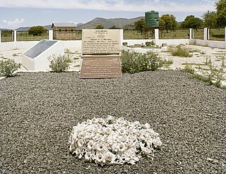
In the Bulhoek massacre, a white police force from the Union of South Africa killed 163 Xhosa civilians. The massacre occurred on 24 May 1921, in the village of Ntabelanga in the Cape Province. After a dispute over land in Ntabelanga, dating back to 1920, an 800-strong police force from the Union of South Africa led by Colonel Johan Davey and General Koos van der Venter gathered at Ingxingwa Ye Nkunzini, in the Bulhoek valley, and Ingxingwa ka Stivini, Steven's Valley. At the same time 500 men known as the "Israelites", armed with spears and knobkerries, and led by Enoch Mgijima, gathered in an open field, ready to defend their families and community. After failed final negotiations between the two parties, a battle ensued. The 20-minute battle, which left an estimated 163 Israelites dead, 129 wounded and 95 taken as prisoners, became known as the Bulhoek Massacre.

Enoch Mgijima was a Xhosa prophet and evangelist. He formed his own church, known as the Israelites, a breakaway from the Church of God and Saints of Christ, and led them through a clash with the white Union of South Africa government, which left 163 Israelites dead, 129 wounded and 95 taken prisoner, in what became known as the Bulhoek Massacre.
Nokuzola Gladys Tolashe, also known as Sisisi "Sisi" Tolashe, is a South African politician from the Eastern Cape. She is the current Minister of Social Development since June 2024. She was also elected as president of the African National Congress (ANC) Women's League in July 2023. In government, Tolashe was the Deputy Minister in the Presidency for Women, Youth and Persons with Disabilities from March 2023 to 30 June 2024.


