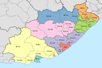
Ingquza Hill Local Municipality

Last updated

Ingquza Hill
Ingquza Hill CoA.png
Map of the Eastern Cape with Qaukeni highlighted.svg
Location in the Eastern Cape
Coordinates: 32°10′S28°35′E / 32.167°S 28.583°E / -32.167; 28.583
Country South Africa
Province Eastern Cape
District OR Tambo
Seat Flagstaff
Wards 31
Government
[1]
  Type Municipal council
  MayorBB Goya (ANC)
  SpeakerNtandokazi Yolisa Chapa (ANC)
  Chief WhipMbongeni Isaac Nkungu (ANC)
Area
  Total2,477 km2 (956 sq mi)
Population
 (2011) [2]
  Total278,481
  Density110/km2 (290/sq mi)
Racial makeup (2011)
[2]
   Black African 99.2%
   Coloured 0.4%
   Indian/Asian 0.1%
   White 0.1%
First languages (2011)
[3]
   Xhosa 94.6%
   English 2.2%
  Other3.2%
Time zone UTC+2 (SAST)
Municipal codeEC153
An aerial view of Mboyti, a small settlement and coastal resort located in the Ingquza Hill Local Municipality close to the town of Lusikisiki on the mouth of the Mboyti River. Moboyti.jpg
An aerial view of Mboyti, a small settlement and coastal resort located in the Ingquza Hill Local Municipality close to the town of Lusikisiki on the mouth of the Mboyti River.

Ingquza Hill Municipality (Xhosa : uMasipala wase Ingquza Hill), previously known as Qaukeni Municipality, is a local municipality within the OR Tambo District Municipality, in the Eastern Cape province of South Africa.

Contents

Main places

The 2001 census divided the municipality into the following main places: [4]

PlaceCodeArea (km2)Population
Amakwalo 23201 123.868,467
Amanci 23202 5.21706
Amantlane 23203 117.1612,588
Awahlwazi 23204 25.034,082
Bala 23205 134.3915,995
Emtweni 23206 53.322,023
Flagstaff 23207 13.773,069
Gunyeni 23208 45.1213,493
Lusikisiki 23209 21.049,079
Lwandlolubomvu 23210 1.2478
Mkambati 23211 173.29800
Mtshayelo 23212 14.631,980
Mxobo 23213 86.089,632
Ndimakude 23214 16.101,765
Sipaqeni 23216 249.3134,069
Taweni 23217 342.8535,362
Xopozo 23218 79.497,835
Remainder of the municipality 23215 958.2594,357

Politics

The municipal council consists of sixty-four members elected by mixed-member proportional representation. Thirty-two councillors are elected by first-past-the-post voting in thirty-two wards, while the remaining thirty-two are chosen from party lists so that the total number of party representatives is proportional to the number of votes received. In the election of 1 November 2021 the African National Congress (ANC) won a majority of forty-six seats on the council. The following table shows the results of the election. [5]

PartyWardListTotal
seats
Votes%SeatsVotes%Seats
African National Congress 41,47867.232844,52975.841846
Economic Freedom Fighters 5,1568.3605,5309.4266
Independent candidates 7,65812.4144
Civic Independent 1,7712.8702,0683.5222
Democratic Alliance 1,8142.9401,5132.5822
African Transformation Movement 1,2111.9601,3692.3311
United Democratic Movement 1,0621.7201,1842.0211
African Independent Congress 3820.6209721.6611
African People's Convention 4860.7904110.7011
Congress of the People 2920.4703920.6700
Pan Africanist Congress of Azania 1840.3002440.4200
African Christian Democratic Party 1930.3101850.3200
Inkatha Freedom Party 60.0103210.5500
Total61,693100.003258,718100.003264
Valid votes61,69397.5058,71894.55
Invalid/blank votes1,5812.503,3835.45
Total votes63,274100.0062,101100.00
Registered voters/turnout139,51745.35139,51744.51

Related Research Articles

<span class="mw-page-title-main">KwaDukuza Local Municipality</span> Local municipality in KwaZulu-Natal, South Africa

KwaDukuza Local Municipality is one of four municipalities under iLembe District Municipality, KwaZulu-Natal, South Africa. As of 2022 it has a population of 324,912.
<span class="mw-page-title-main">Mbhashe Local Municipality</span> Local municipality in Eastern Cape, South Africa

Mbhashe Municipality is a local municipality in the Eastern Cape province of South Africa. The municipality was constituted in terms of the Municipal Structures Act of 1998 and comprises the areas that previously formed the Elliotdale, Willowvale and Dutywa town councils. The municipality is located in the north eastern part of the Amathole District Municipality. The main administrative office is situated in Dutywa.

<span class="mw-page-title-main">Emalahleni Local Municipality, Mpumalanga</span> Local municipality in Mpumalanga, South Africa

Emalahleni Municipality is a local municipality within the Nkangala District Municipality, in the Mpumalanga province of South Africa. eMalahleni is a Nguni word meaning place of coal.

<span class="mw-page-title-main">Mogale City Local Municipality</span> Local municipality in Gauteng, South Africa

Mogale City Local Municipality is a local municipality within the West Rand District Municipality, in the Gauteng province of South Africa.
<span class="mw-page-title-main">Nkomazi Local Municipality</span> Local municipality in Mpumalanga, South Africa

Nkomazi Municipality is a local municipality within the Ehlanzeni District Municipality, in the Mpumalanga province of South Africa. Malalane is the seat of the municipality.

<span class="mw-page-title-main">Molemole Local Municipality</span> Local municipality in Limpopo, South Africa

Molemole Municipality is a local municipality within the Capricorn District Municipality, in the Limpopo province of South Africa. The seat is Mogwadi.
<span class="mw-page-title-main">Thembisile Hani Local Municipality</span> Local municipality in Mpumalanga, South Africa

Thembisile Hani Municipality is a local municipality within the Nkangala District Municipality, in the Mpumalanga province of South Africa. It is a semi-urban local municipality consisting of 57 villages within which there are 5 established townships.
<span class="mw-page-title-main">Moses Kotane Local Municipality</span> Local municipality in North West, South Africa

Moses Kotane Municipality is a local municipality within the Bojanala Platinum District Municipality, in the North West province of South Africa. It is named in memory of Moses Kotane. The seat of the municipality is Mogwase.

<span class="mw-page-title-main">Mahikeng Local Municipality</span> Local municipality in North West, South Africa

Mahikeng Municipality is a local municipality within the Ngaka Modiri Molema District Municipality, in the North West province of South Africa. Mahikeng is a Setswana word meaning "place of rocks".

<span class="mw-page-title-main">Ditsobotla Local Municipality</span> Local municipality in North West, South Africa

Ditsobotla Municipality is a local municipality within the Ngaka Modiri Molema District Municipality, in the North West province of South Africa. The seat of the municipality is Lichtenburg.

<span class="mw-page-title-main">Maquassi Hills Local Municipality</span> Local municipality in North West, South Africa

Maquassi Hills Municipality is a local municipality within the Dr Kenneth Kaunda District Municipality, in the North West province of South Africa.

<span class="mw-page-title-main">King Sabata Dalindyebo Local Municipality</span> Local municipality in Eastern Cape, South Africa

King Sabata Dalindyebo Municipality is a local municipality situated in the inland of the Eastern Cape province of South Africa. The municipality includes the towns of Mthatha and Mqanduli. The King Sabata Dalindyebo Municipality is one of the seven local municipalities within the OR Tambo District Municipality.

<span class="mw-page-title-main">Newcastle Local Municipality</span> Local municipality in KwaZulu-Natal, South Africa

Newcastle Municipality is a local municipality within the Amajuba District Municipality, in the KwaZulu-Natal province of South Africa.

<span class="mw-page-title-main">Mnquma Local Municipality</span> Local municipality in Eastern Cape, South Africa

Mnquma Municipality is a local municipality within the Amatole District Municipality, in the Eastern Cape of South Africa.

<span class="mw-page-title-main">Emalahleni Local Municipality, Eastern Cape</span> Local municipality in Eastern Cape, South Africa

Emalahleni Municipality is a local municipality within the Chris Hani District Municipality, in the Eastern Cape province of South Africa. Emalahleni is an isiXhosa word meaning "a place of coal".

<span class="mw-page-title-main">Amahlathi Local Municipality</span> Local municipality in Eastern Cape, South Africa

Amahlathi Municipality is a local municipality within the Amatole District Municipality, in the Eastern Cape province of South Africa. Amahlati is an isiXhosa word meaning "a place where many trees are grouped together, a forest". Forests are a key feature of the area.
<span class="mw-page-title-main">Port St. Johns Local Municipality</span> Local municipality in Eastern Cape, South Africa

Port St. Johns Municipality is a local municipality within the OR Tambo District Municipality, in the Eastern Cape province of South Africa.

<span class="mw-page-title-main">Dr AB Xuma Local Municipality</span> Local municipality in Eastern Cape, South Africa

Dr AB Xuma Local Municipality is a local municipality within the Chris Hani District Municipality, in the Eastern Cape province of South Africa. Ngcobo is an isiXhosa word for a sweet grass found in the area.
<span class="mw-page-title-main">Senqu Local Municipality</span> Local municipality in Eastern Cape, South Africa

Senqu Municipality is a local municipality within the Joe Gqabi District Municipality, in the Eastern Cape province of South Africa. Senqu is the Sesotho name for the Orange River.

The Ingquza Hill Local Municipality council consists of sixty-four members elected by mixed-member proportional representation. Thirty-two councillors are elected by first-past-the-post voting in thirty-two wards, while the remaining thirty-two are chosen from party lists so that the total number of party representatives is proportional to the number of votes received. In the election of 1 November 2021 the African National Congress (ANC) won a majority of forty-six seats.

References

  1. "Contact list: Executive Mayors". Government Communication & Information System. Archived from the original on 14 July 2010. Retrieved 22 February 2012.
  2. 1 2 "Statistics by place". Statistics South Africa. Retrieved 27 September 2015.
  3. "Statistics by place". Statistics South Africa. Retrieved 27 September 2015.
  4. Lookup Tables - Statistics South Africa [ permanent dead link ]
  5. "Election Result Table for LGE2021 — Ingquza Hill". wikitable.frith.dev. Retrieved 26 December 2021.