South Africa is administered under nine provinces.[1] On the eve of the 1994 general election, South Africa's former homelands, known as Bantustans, were reintegrated into the country, and the four provinces were increased to nine. The borders of Natal and the Orange Free State were retained, while the Cape Province and Transvaal Province were divided into three provinces each, plus North West Province which straddles the border of and contains territory from both these two former provinces. The twelfth, thirteenth and sixteenth amendments to the Constitution of South Africa changed the borders of seven of the provinces.
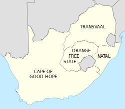
Provinces and homelands, as they were at the end of apartheid
Segregation of the black population started as early as 1913, with ownership of land by the black majority being restricted to certain areas totalling about 13% of the country. From the late 1950s, these areas were gradually consolidated into "homelands", also called "bantustans". Four of these homelands were established as quasi-independent nation states of the black population during the apartheid era. In 1976, the homeland of Transkei was the first to accept independence from South Africa, and although this independence was never acknowledged by any other country, three other homelands–Bophuthatswana (1977), Venda (1979) and Ciskei (1981)– followed suit.
On 27 April 1994, the date of the first non-racial elections and of the adoption of the Interim Constitution, all of these provinces and homelands were dissolved, and nine new provinces were established. The boundaries of these provinces were established in 1993 by a Commission on the Demarcation/Delimitation of Regions created by CODESA, and were broadly based on planning regions demarcated by the Development Bank of Southern Africa in the 1980s,[2][3] and amalgamated from existing magisterial districts, with some concessions to political parties that wished to consolidate their power bases, by transferring districts between the proposed provinces.[4][5] The definitions of the new provinces in terms of magisterial districts were found in Schedule 1 of the Interim Constitution.
South Africa's provinces are governed, in different ways, on a national, provincial and local level.[6]
Nationally, there is the National Council of Provinces, one of the houses of Parliament. Then there is the provincial government and, below that, the administration of district and metropolitan municipalities.
South Africa has two houses of parliament: the National Assembly, and the National Council of Provinces.[6] The second exists to ensure that the interests of each province are protected in the laws passed by the National Assembly.
Each one of South Africa's nine provinces sends 10 representatives to the National Council of Provinces. Six of these are permanent members of the council, and four are special delegates.
The provincial legislature elects, from amongst its members, a Premier, who is the head of the executive. The Premier chooses an Executive Council consisting of between five and ten members of the legislature, which is the cabinet of the provincial government.[7] The Members of the Executive Council (MECs) are the provincial equivalent of ministers.
The powers of the provincial government are limited to specific topics listed in the national constitution. On some of these topics–for example, agriculture, education, health and public housing–the province's powers are shared with the national government, which can establish uniform standards and frameworks for the provincial governments to follow; on other topics the provincial government has exclusive power.[8]
The provinces do not have their own court systems, as the administration of justice is the responsibility of the national government.
↑Pietermaritzburg and Ulundi were joint capitals of KwaZulu-Natal from 1994 to 2004.
↑These statistics do not include the Prince Edward Islands (335km2 or 129sqmi, with no permanent residents), which are South African territories in the sub-AntarcticIndian Ocean but part of the Western Cape for legal and electoral purposes.
↑Parliament sits in Cape Town, the Supreme Court of Appeal in Bloemfontein, and the executive branch in Pretoria.
Provincial acronyms
Province
HASC
ISO
FIPS
CSS
Conventional
Eastern Cape
ZA.EC
EC
SF05
02
EC
Free State
ZA.FS
FS
SF03
04
FS
Gauteng
ZA.GT
GP
SF06
07
GP
KwaZulu-Natal
ZA.NL
KZN
SF02
05
KZN
Limpopo
ZA.NP
LP
SF09
09
LP
Mpumalanga
ZA.MP
MP
SF07
08
MP
Northern Cape
ZA.NC
NC
SF08
03
NC
North-West
ZA.NW
NW
SF10
06
NW
Western Cape
ZA.WC
WC
SF11
01
WC
Notes
HASC: Hierarchical administrative subdivision codes ISO: Province codes from ISO 3166-2. For full identification in a global context, prefix "ZA-" to the code FIPS: Codes from FIPS PUB 10–4, a U.S. government standard. CSS: Province codes used by the Central Statistical Service of South Africa. [13]
↑Muthien, Yvonne G.; Khosa, Meshack M. (1995). "'The kingdom, the Volkstaat and the New South Africa': Drawing South Africa's new regional boundaries". Journal of Southern African Studies. 21 (2): 303–322. doi:10.1080/03057079508708448.
This page is based on this Wikipedia article Text is available under the CC BY-SA 4.0 license; additional terms may apply. Images, videos and audio are available under their respective licenses.