Hardap is one of the fourteen regions of Namibia, its capital is Mariental. Hardap contains the municipality of Mariental, the towns Rehoboth and Aranos, and the self-governed villages Gibeon, Gochas, Kalkrand, Stampriet and Maltahöhe. It is home to the Hardap Dam.

The ǁKharas Region is the southernmost, largest, and least densely populated of the 14 regions of Namibia; its capital is Keetmanshoop. The name assigned to the region reflects the prominence of the Karas mountain range in its southern part. The ǁKharas region contains the municipality of Keetmanshoop, the towns Karasburg, Lüderitz and Oranjemund, and the self-governed villages Aroab, Berseba, Bethanie, Koës and Tses.

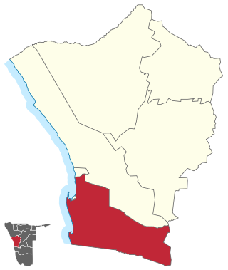
Erongo is one of the 14 regions of Namibia. The capital is Swakopmund. It is named after Mount Erongo, a well-known landmark in Namibia and in this area. Erongo contains the municipalities of Walvis Bay, Swakopmund, Henties Bay and Omaruru, as well as the towns Arandis, Karibib and Usakos. All the main centres within this region are connected by paved roads.

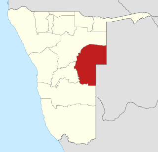
Khomas is one of the fourteen regions of Namibia. Its name refers to the Khomas Highland, a high plateau landscape that dominates this administrative subdivision. Khomas is centered on the capital city Windhoek and provides for this reason superior transportation infrastructure. It is located in the central highlands of the country and is bordered by the Erongo region to the west and the northwest and by the Otjozondjupa region to the north. To the east is the Omaheke region, while in the south is the Hardap region. The region is characterized by its hilly countrysize and many valleys. It has well-developed economical, financial, and trade sectors. Khomas Region occupies 4.5% of the land area of Namibia but has the highest population of any of its regions (16.2%). Khomas is one of only three Namibian regions to have neither shoreline nor a foreign border.

Otjozondjupa is one of the fourteen regions of Namibia. Its capital is Otjiwarongo. The region further contains the municipalities of Okahandja and Grootfontein and the towns Okakarara and Otavi. As of 2020, Otjozondjupa had 97,945 registered voters.
Omaheke is one of the fourteen regions of Namibia, the least populous region. Its capital is Gobabis. It lies in eastern Namibia on the border with Botswana and is the western extension of the Kalahari desert. The self-governed villages of Otjinene, Leonardville and Witvlei are situated in the region. As of 2020, Omaheke had 48,594 registered voters.

Kunene is one of the fourteen regions of Namibia. Its capital is Opuwo, its governor is Marius Sheya. The region's name comes from the Kunene River which forms the northern border with Angola. Besides the capital Opuwo, the region contains the municipality of Outjo, the town Khorixas and the self-governed village Kamanjab. Kunene is home to the Himba people, a subtribe of the Herero, as well as to Damara people and Nama people. As of 2020, Kunene had 58,548 registered voters.

Swakopmund is a city on the coast of western Namibia, 352 km (219 mi) west of the Namibian capital Windhoek via the B2 main road. It is the capital of the Erongo administrative district. As of 2011, the town had 44,725 inhabitants and 196 km2 (76 sq mi) of land. In 2023, the population had increased to 75,921 people.

Omaruru is a town in the Erongo Region of central Namibia. The town has 14,000 inhabitants and encompasses 352 square kilometres (136 sq mi) of land. It is situated near Mount Erongo, on the usually dry Omaruru River. It is located on the main paved road from Swakopmund to Otjiwarongo. The name in the Otjiherero language means 'bitter milk', as Herero cattle herds used to graze on the local bush that turned their milk bitter.

Dâures is a constituency in the Erongo Region of Namibia. It is named after the tallest mountain in Namibia, the Brandberg. It had a population of 11,350 in 2011, up from 10,289 in 2001. As of 2020 the constituency had 7,882 registered voters.

Samora Machel Constituency is a constituency in Windhoek in the Khomas Region of central Namibia. The constituency is located across four northern suburbs of Windhoek: Wanaheda, Greenwell Matongo, Goreangab, and part of Havana. It had a population of 50,110 in 2011, up from 29,382 in 2001. As of 2020 it had 45,962 registered voters.

Khomasdal Constituency is a constituency in Windhoek in the Khomas Region of Namibia. As of December 2019 it had 25,550 registered voters. The constituency consists of parts of the suburbs Khomasdal, Katutura, and Otjomuise. It had a population of 43,921 in 2011, up from 27,950 in 2001.

Uttar Dinajpur, also known as North Dinajpur, is a district of the Indian state of West Bengal. Created on 1 April 1992 by the division of the erstwhile West Dinajpur district, it comprises two subdivisions: Raiganj and Islampur.
Tobias Hainyeko constituency is an electoral constituency in Windhoek, the capital of Namibia. It had a population of 45,912 in 2011, up from 34,348 in 2001. As of 2020 it had 36,530 registered voters.

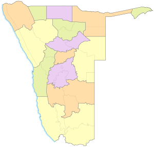
Namibia is divided into 14 regions subdivided, which are further subdivided into 121 constituencies. The administrative divisions of Namibia are tabled by Delimitation Commissions and accepted or declined by the National Assembly.

Moses ǁGaroëb Constituency is an electoral constituency in Windhoek, the capital of Namibia. It had a population of 45,564 in 2011, up from 25,642 in 2001. As of 2020 it had 41,550 registered voters.
Walvis Bay Rural constituency is a constituency in the Erongo Region of Namibia. It comprises the rural area surrounding the constituency's district capital city of Walvis Bay, and additionally some streets on the outskirts of the city. It had a population of 26,916 in 2011, up from 16,293 in 2001. As of 2020 the constituency had 25,746 registered voters.

Walvis Bay Urban is a constituency in the Erongo Region of Namibia, comprising most of the city of Walvis Bay. It had a population of 35,828 in 2011, up from 27,941 in 2001. As of 2020 the constituency had 25,311 registered voters.