 |
|---|
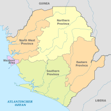
Sierra Leone is divided into four provinces (until 2017, three) and one Western Area; these are further divided into 16 districts (previously 14), and the districts are further divided into 190 (previously 149) chiefdoms. [1]
| |
|---|
Sierra Leone is divided into four provinces (until 2017, three) and one Western Area; these are further divided into 16 districts (previously 14), and the districts are further divided into 190 (previously 149) chiefdoms. [1]
| Province/Area name | Capital | Area | Population (2015 census) | Population Density |
|---|---|---|---|---|
| Eastern Province | Kenema | 15,553 km2 (6,005 sq mi) | 1,641,012 | 110/km2 (270/sq mi) |
| Northern Province [lower-alpha 1] | Makeni | TBD | 2,502,865 | 70/km2 (180/sq mi) |
| Southern Province | Bo | 19,694 km2 (7,604 sq mi) | 1,438,572 | 73/km2 (190/sq mi) |
| North West Province [lower-alpha 2] | Port Loko | TBD | 1,162,065 | 70/km2 (180/sq mi) |
| Western Area | Freetown | 557 km2 (215 sq mi) | 1,493,252 | 2,700/km2 (6,900/sq mi) |

Sierra Leone, officially the Republic of Sierra Leone, is a country on the southwest coast of West Africa. It is bordered to the southeast by Liberia and by Guinea to the north. Its land area is 71,740 km2 (27,699 sq mi). It has a tropical climate and environments ranging from savannas to rainforests. As of the 2015 census, Sierra Leone had a population of 7,092,113. Freetown is both its capital and its largest city. The country is divided into five administrative regions, which are further subdivided into 16 districts.

Sierra Leone is a country located in West Africa, known officially as the Republic of Sierra Leone.

Freetown is the capital and largest city of Sierra Leone. It is a major port city on the Atlantic Ocean and is located in the Western Area of the country. Freetown is Sierra Leone's major urban, economic, financial, cultural, educational and political centre, as it is the seat of the Government of Sierra Leone. The population of Freetown was 1,347,559 as of the 2024 census.
The government of Sierra Leone is the governing authority of the Republic of Sierra Leone, as established by the Sierra Leone Constitution. The Sierra Leone government is divided into three branches: the executive, legislative and the judiciary. The seat of government of Sierra Leone is in the capital Freetown.
The Church of the Province of West Africa is a province of the Anglican Communion, covering 17 dioceses in eight countries of West Africa, specifically in Cameroon, Cape Verde, Gambia, Ghana, Guinea, Liberia, Senegal and Sierra Leone. Ghana is the country with most dioceses, now numbering 11.
The provinces of Sierra Leone are divided into 16 districts, as of July 2017. Previously, the country was divided into 14 districts. The Western Area is divided into two districts. Sierra Leone's capital Freetown is located in the Western Area of the country and its makes up the Western Area Urban District.

Makeni is the largest city in the Northern Province of Sierra Leone. The city is the capital of Bombali District, and is the economic center of the Northern Province. Makeni is the fifth largest city in Sierra Leone by population. The city of Makeni had a population of 85,116 in the 2021 census. Makeni lies approximately 110 miles east of Freetown. Makeni is home to the University of Makeni, the largest private university in Sierra Leone.

The Southern Province is one of the four provinces of Sierra Leone. It covers an area of 19,694 km² and has a population of 1,438,572. It consists of four districts. Its capital and administrative center is Bo, which is also the second largest and second most populated city in Sierra Leone after the nation's capital Freetown. The population of the southern province is largely from the Mende ethnic group.

The Western Area or Freetown Peninsula is one of five principal divisions of Sierra Leone. It comprises the oldest city and national capital Freetown and its surrounding towns and countryside. It covers an area of 557 km2 and has a population of 1,447,271. The Western Area is located mostly around the peninsula and is divided into two districts: the Western Area Rural and the Western Area Urban.

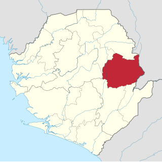
The Northern Province is one of the five provincial divisions of Sierra Leone. It is located in the Northern geographic region of Sierra Leone. It comprises the following four Districts: Bombali, Falaba, Koinadugu and Tonkolili. The Northern Province covers an area of 35,936 km2 (13,875 sq mi) with a population of 2,502,865, based on the 2015 Sierra Leone national census. Its administrative and economic center is Makeni. The North borders the North West Province to the West, the Republic of Guinea to the north-east, the Eastern Province and Southern Province to the south-east.

The Eastern Province is one of the four provinces of Sierra Leone. It covers an area of 15,553 km2 and has a population of 1,641,012. Its capital and administrative centre is Kenema. Eastern Province, the centre of the country's diamond mining industry, is very mountainous and has two ranges, the Gola Hills and the Loma Mountains.

The Limba people are an ethnic group in Sierra Leone. They represent 12.4% of the total population, making them the third largest ethnic group in Sierra Leone. The Limba are based in the north of the country across seven provinces, but are predominantly found in the Northern Province of Sierra Leone.
Kono District is a district in the Eastern Province of Sierra Leone. Its capital and largest city is Koidu Town. Motema is the second most populous city in the district. The other major towns in the district include Yengema, Tombodu, Jaiama Nimikor and Sewafe. The district is the largest diamond producer in Sierra Leone. The population of Kono District is 505,767. Kono District borders Kenema District to the southwest, The Republic of Guinea to the east, Koinadugu District to the northeast and Kailahun District to the southeast. Kono District is divided into fourteen chiefdoms.
Tongo, also known as Tongoma, is a diamond mining town and the second largest city in Kenema District, located in the Eastern Province of Sierra Leone. Tongo is about 27 miles to Kenema. The population of the 60-sq.-mile city is 44,376.

The Sierra Leone Police (SLP) is the national police force of the Republic of Sierra Leone. It is primarily responsible for law enforcement and crime investigation throughout Sierra Leone. The Sierra Leone Police is under the jurisdiction of the Sierra Leone Ministry of Internal Affairs, a cabinet ministry in the Government of Sierra Leone.
The chiefdoms of Sierra Leone are the third-level units of administration in Sierra Leone. There are 190 chiefdoms in Sierra Leone, as of 2017. Previously, there were 149.
The subdivisions of Sierra Leone are as follows:

Sierra Leone is home to about sixteen ethnic groups, each with its own language. In Sierra Leone, membership of an ethnic group often overlaps with a shared religious identity. According to the 2004 census Temne is the largest ethnic group in Sierra Leone.
Kholifa Rowalla Chiefdom is a chiefdom in Tonkolili District of Sierra Leone. Its capital is Magburaka. Sierra Leone is divided into 3 provinces and the Western Area with a total of 149 chiefdoms and 12 districts.