Provinces of the Democratic Republic of the Congo

Last updated
Provinces of the Democratic Republic of the Congo
Provinces de la République démocratique du Congo (French)
  • Also known as:
  • Mikoa ya Jamhuri ya Kidemokrasia ya Kongo (Swahili)
    Bitúká bya Kongó-Kinsásá (Lingala)
2006 Nouvelles provinces de la Republique Democratique du Congo.png Provinces de la Republique democratique du Congo - 2005.svg
Category1st-level administrative division of a unitary state
Location Democratic Republic of the Congo
Number26 provinces (1 is a city-province)
Populations1,250,000 (Bas-Uele) – 13,916,000 (Kinshasa)
Areas9,545 km2 (3,685 sq mi) (Kasaï-Oriental) – 199,567 km2 (77,053 sq mi) (Tshopo)
Government
  • Provincial government
Subdivisions

Article 2 of the Constitution of the Democratic Republic of the Congo divides the country into the capital city of Kinshasa and 25 named provinces. It also gives the capital the status of a province. [1] Therefore, in many contexts Kinshasa is regarded as the 26th province.

Contents

List

MapProvince ISO
3166-2
Code
CapitalArea in km2
(sq mi) [2]
Population
(2019) [2]
Population density

(per km2in 2019)

Previous
province
Time
zone
1 Kinshasa KN9,965 (3,848)13,916,0001,396.5 Kinshasa UTC+1
2 Kongo Central BC Matadi 53,920 (20,820)6,365,000118 Bas-Congo UTC+1
3 Kwango KG Kenge 89,974 (34,739)2,416,00026.9 Bandundu UTC+1
4 Kwilu KL Bandundu 78,533 (30,322)6,169,00078.6 Bandundu UTC+1
5 Mai-Ndombe MN Inongo 127,243 (49,129)2,082,00016.4 Bandundu UTC+1
6 Kasaï KS Tshikapa 95,631 (36,923)3,165,00033.1 Kasaï-Occidental UTC+2
7 Kasaï-Central KC Kananga 59,500 (23,000)3,743,00062.9 Kasaï-Occidental UTC+2
8 Kasaï-Oriental KE Mbuji-Mayi 9,545 (3,685)3,601,000377.3 Kasaï-Oriental UTC+2
9 Lomami LO Kabinda 56,426 (21,786)2,801,00049.6 Kasaï-Oriental UTC+2
10 Sankuru SA Lusambo 104,331 (40,282)2,417,00023.2 Kasaï-Oriental UTC+2
11 Maniema MA Kindu 132,250 (51,060)2,654,00020.1 Maniema UTC+2
12 South Kivu SK Bukavu 64,791 (25,016)6,565,000101.3 South Kivu UTC+2
13 North Kivu NK Goma 59,483 (22,967)7,574,000127.3 North Kivu UTC+2
14 Ituri IT Bunia 65,658 (25,351)4,008,00061 Orientale UTC+2
15 Haut-Uele HU Isiro 89,683 (34,627)2,046,00022.8 Orientale UTC+2
16 Tshopo TO Kisangani 199,567 (77,053)2,582,00012.9 Orientale UTC+2
17 Bas-Uele BU Buta 148,331 (57,271)1,250,0008.4 Orientale UTC+2
18 Nord-Ubangi NU Gbadolite 56,644 (21,870)1,425,00025.1 Équateur UTC+1
19 Mongala MO Lisala 58,141 (22,448)1,950,00033.5 Équateur UTC+1
20 Sud-Ubangi SU Gemena 51,648 (19,941)2,755,00053.3 Équateur UTC+1
21 Équateur EQ Mbandaka 103,902 (40,117)1,712,00016.5 Équateur UTC+1
22 Tshuapa TU Boende 132,957 (51,335)1,789,00013.5 Équateur UTC+1
23 Tanganyika TA Kalemie 134,940 (52,100)3,570,00024.5 Katanga UTC+2
24 Haut-Lomami HL Kamina 108,204 (41,778)3,444,00031.8 Katanga UTC+2
25 Lualaba LU Kolwezi 121,308 (46,837)2,993,00024.7 Katanga UTC+2
26 Haut-Katanga HK Lubumbashi 132,425 (51,130)5,378,00040.6 Katanga UTC+2

History

When Belgium annexed the Belgian Congo as a colony in November 1908, it was initially organised into 22 districts. Ten western districts were administered directly by the main colonial government, while the eastern part of the colony was administered under two vice-governments: eight northeastern districts formed Orientale Province, and four southeastern districts formed Katanga. In 1919, the colony was organised into four provinces:

In 1932, the colony was reorganised into six provinces. Initially they were named after their capital cities, but in 1947 regional names were adopted. [3]

The Belgian Congo became an independent country in 1960, named Republic of the Congo. By 1963, the country was organised into 21 provinces (informally called provincettes) plus the capital city of Léopoldville, similar to the original 22 districts under colonial rule. In 1966, the 21 provincettes were grouped into eight provinces, and the capital city was renamed Kinshasa. [3]

In 1971, the country was renamed Zaire, and three provinces were also renamed. In 1975, the capital city of Kinshasa obtained the status of a province. In 1988, the province of Kivu was split into three. In 1997, the country was renamed Democratic Republic of the Congo, and the three provinces that had been renamed in 1971 either retook their previous name or took another. [3]

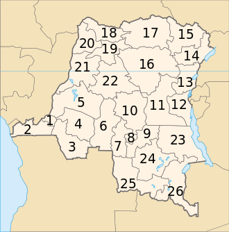
Article 2 of the Constitution of the Democratic Republic of the Congo, adopted in 2006, specifies a territorial organisation into 26 provinces, [4] again resembling the previous provincettes and original colonial districts. The reorganisation was scheduled to take effect within three years of the new constitution's promulgation, however progress was slow. [5] In October 2007 the Minister for Decentralisation, Denis Kalume Numbi, presented a bill for decentralisation in the National Assembly. The subsequent debate turned up a variety of issues that first had to be addressed with changes to related laws. [6] In an October 2010 conclave of the ruling AMP coalition, it was proposed to revise Article 226, which calls for the creation of 26 provinces out of the current 11, in order to allow more time for the transition. [7] On 9 January 2015 the National Assembly passed a law on the new administrative divisions of the country, according to which new provinces should be installed in period of 12 months. [8] [9]

Maps

Approximate correspondence between historical and current provinces

Approximate correspondence between historical and current provinces
Belgian CongoFirst RepublicSecond Republic (Zaire)Third Republic
1908191919321947196319661971198819972015
22 districts4 provinces6 provinces6 provinces21 provinces + capital8 provinces + capital8 regions + capital11 regions11 provinces26 provinces
Tanganika-Moero KatangaÉlisabethvilleKatanga Nord-Katanga Katanga Shaba Katanga Tanganyika
Haut-Lomami
Lulua Lualaba Lualaba
Haut-Luapula Katanga-Oriental Haut-Katanga
Lomami LusamboKasaïLomami Kasaï-Oriental Lomami
Sankuru Congo-Kasaï Sankuru Sankuru
Kasaï Sud-Kasaï Kasaï-Oriental
Luluabourg Kasaï-Occidental Kasaï-Central
Unité-Kasaïenne Kasaï
Moyen-Congo LéopoldvilleLéopoldville Kinshasa
Bas-Congo Congo-CentralBas-ZaïreBas-Congo Kongo Central
Kwango Kwango Bandundu Kwango
Kwilu Kwilu
Lac Léopold II Équateur Mai-Ndombe Mai-Ndombe
Équateur CoquilhatvilleÉquateurCuvette-Centrale Équateur Équateur
Tshuapa
Lulonga Moyen-Congo Mongala
Bangala
Ubangi Ubangi Nord-Ubangi
Sud-Ubangi
Bas-Uele OrientaleStanleyvilleOrientaleUeleOrientaleHaut-Zaïre Orientale Bas-Uele
Haut-Uele Haut-Uele
Ituri Kibali-Ituri Ituri
Stanleyville Haut-Congo Tshopo
Aruwimi
Maniema Costermansville Kivu Maniema Kivu Maniema
Lowa
Kivu Nord-Kivu Nord-Kivu
Kivu-Central Sud-Kivu

See also

Related Research Articles

<span class="mw-page-title-main">Katanga Province</span> Former province in DR Congo

Katanga was one of the four large provinces created in the Belgian Congo in 1914. It was one of the eleven provinces of the Democratic Republic of the Congo between 1966 and 2015, when it was split into the Tanganyika, Haut-Lomami, Lualaba, and Haut-Katanga provinces. Between 1971 and 1997, its official name was Shaba Province.

<span class="mw-page-title-main">Kongo Central</span> Province of the Democratic Republic of the Congo

Kongo Central, formerly Bas-Congo, is one of the 26 provinces of the Democratic Republic of the Congo. Its capital is Matadi.

<span class="mw-page-title-main">Équateur (former province)</span> Place in Democratic Republic of the Congo

Équateur was a province in the northwest of the Belgian Congo and the successor Republic of the Congo, now known as Democratic Republic of the Congo. It had its origins in the Équateur District of the Congo Free State, the private property of King Leopold II of Belgium. It was upgraded to the status of a province in 1917. Between 1933 and 1947 it was named Coquilhatville. In 1962 it was divided into three smaller provinces, but there were recombined in 1966. Équateur was one of the eleven provinces of the Democratic Republic of the Congo until 2015, when it was split into the new, smaller Équateur province, as well as the Tshuapa, Mongala, Nord-Ubangi and Sud-Ubangi provinces.

<span class="mw-page-title-main">Orientale Province</span> Province in Democratic Republic of the Congo

Orientale Province is one of the former provinces of the Democratic Republic of the Congo and its predecessors the Congo Free State and the Belgian Congo. It went through a series of boundary changes between 1898 and 2015, when it was divided into smaller units.

<span class="mw-page-title-main">Subdivisions of the Democratic Republic of the Congo</span> Territorial organization of the DR Congo

The Third Republic of the Democratic Republic of the Congo is a unitary state with a five-level hierarchy of types of administrative division. There are nine different types of country subdivision in a new hierarchy with no new types but with two from the previous one abolished.

<span class="mw-page-title-main">Province of Équateur</span> Province of the Democratic Republic of the Congo

Équateur is one of the 21 new provinces of the Democratic Republic of the Congo created in the 2015 repartitioning. Équateur, Mongala, Nord-Ubangi, Sud-Ubangi, and Tshuapa provinces are the result of the dismemberment of the former Équateur province. The new province was formed from the Équateur district and the independently administered city of Mbandaka which retained its status as a provincial capital.

<span class="mw-page-title-main">Languages of the Democratic Republic of the Congo</span>

The Democratic Republic of the Congo is a multilingual country where an estimated total of 242 languages are spoken. Ethnologue lists 215 living languages. The official language, since the colonial period, is French, one of the languages of Belgium. Four other languages, three of them Bantu based, have the status of national language: Kikongo, Lingala, Swahili and Tshiluba.

<span class="mw-page-title-main">Republic of the Congo (Léopoldville)</span> 1960–1965 state in Central Africa

The Republic of the Congo was a sovereign state in Central Africa, created with the independence of the Belgian Congo in 1960. From 1960 to 1966, the country was also known as Congo-Léopoldville to distinguish it from its northwestern neighbor, which is also called the Republic of the Congo, alternatively known as "Congo-Brazzaville". In 1964, the state's official name was changed to the Democratic Republic of the Congo, but the two countries continued to be distinguished by their capitals; with the renaming of Léopoldville as Kinshasa in 1966, it became also known as Congo-Kinshasa. After Joseph Désiré Mobutu, commander-in-chief of the national army, seized control of the government in 1965, the Democratic Republic of the Congo became the Republic of Zaire in 1971. It would again become the Democratic Republic of the Congo in 1997. The period between 1960 and 1964 is referred to as the First Congolese Republic.

<span class="mw-page-title-main">Districts of the Democratic Republic of the Congo</span>

The provinces of the Democratic Republic of the Congo were divided into 26 districts. Those in turn were divided into territories or communes.

<span class="mw-page-title-main">Lualaba District</span> District in Katanga, Democratic Republic of the Congo

Lualaba District was a district of the pre-2015 Katanga Province in the Democratic Republic of the Congo. The district dates back to the days of the Congo Free State and the Belgian Congo. The original Lualaba District was merged into Katanga in 1910, but in 1933 a new Lualaba District was formed within Katanga. After various significant boundary changes, in 2015 the district became the western part of the present Lualaba Province.

<span class="mw-page-title-main">Kabinda District</span>

Kabinda District was a district of the Belgian Congo and the Democratic Republic of the Congo. In 2015 it was merged with the independently administered city of Mwene-Ditu to form Lomami Province.

<span class="mw-page-title-main">Équateur District</span> District in Équateur Province, Democratic Republic of the Congo

Équateur District was a former district of the Congo Free State, Belgian Congo and Democratic Republic of the Congo. In 1914 it became part of former Équateur Province. The district went through various changes of extent and name over the years. The original district roughly corresponds to the current provinces of Équateur and Tshuapa.

<span class="mw-page-title-main">Kwango</span> Province of the Democratic Republic of the Congo

Kwango is a province of the Democratic Republic of the Congo. It's one of the 21 provinces created in the 2015 repartitioning. Kwango, Kwilu, and Mai-Ndombe provinces are the result of the dismemberment of the former Bandundu province. Kwango was formed from the Kwango district whose town of Kenge was elevated to capital city of the province.

<span class="mw-page-title-main">Haut-Lomami District</span> District in Katanga, Democratic Republic of the Congo

Haut-Lomami District was a district of the pre-2015 Katanga Province in the Democratic Republic of the Congo. The district dates back to the days of the Belgian Congo. At its greatest extent it roughly corresponded to the northern part of the current Lualaba Province and to the present Haut-Lomami Province.

<span class="mw-page-title-main">Districts of the Belgian Congo</span>

The Districts of the Belgian Congo were the primary administrative divisions when Belgium annexed the Congo Free State in 1908, each administered by a district commissioner. In 1914 they were distributed among four large provinces, with some boundary changes. In 1933 the provinces were restructured into six, again with boundary changes. The number of districts fluctuated between 12 and 26 through splits and consolidations, first rising, then falling, then rising again.

<span class="mw-page-title-main">Stanleyville District</span> District in Orientale, Democratic Republic of the Congo

Stanleyville District was a district of the Belgian Congo and Democratic Republic of the Congo. It went through various changes in extent. Between 1933 and 1963 it had roughly the same extent as the current Tshopo province.

Haut-Luapula District was a district of the Belgian Congo from 1912 to 1933, when it was dissolved. It roughly corresponded to the southern part of the present Haut-Katanga Province.

Tanganika-Moero District was a district of the Belgian Congo from 1912 to 1933, when it was dissolved. It roughly corresponded to the present Tanganyika Province and the northern part of Haut-Katanga Province.

<span class="mw-page-title-main">Tanganika District</span> District in Katanga, Democratic Republic of the Congo

Tanganika District was a district of the pre-2015 Katanga Province in the Democratic Republic of the Congo. The district dates back to the days of the Belgian Congo. At its greatest extent it roughly corresponded to the present Tanganyika Province, with a small portion in the southwest now in Haut-Lomami Province.

Luapula-Moero District was a district of the pre-2015 Katanga Province in the Belgian Congo and Democratic Republic of the Congo. It roughly corresponded in area to the present Haut-Katanga Province.

References

  1. "Constitution de la Republique Democratique du Congo" [The Constitution of the Democratic Republic of the Congo](PDF). LEGANET.CD (in French). 20 January 2011. Article 2. Archived (PDF) from the original on 21 February 2019. Retrieved 11 Jan 2020.
  2. 1 2 "Annuaire statistique RDC 2020" [Statistical Yearbook DRC 2020](PDF) (in French). National Institute of Statistics of the Democratic Republic of the Congo. March 2021. Archived (PDF) from the original on 2022-12-11. Retrieved 2022-12-11.
  3. 1 2 3 4 Provinces of the Democratic Republic of Congo Archived 2012-02-05 at the Wayback Machine , Statoids, accessed 1 May 2016.
  4. Constitution of the Democratic Republic of the Congo, article 2 Archived 2011-10-25 at the Wayback Machine , Wikisource. (in French)
  5. "Provinces of the Democratic Republic of Congo (Congo Kinshasa)". Statoids. Archived from the original on 2012-02-05. Retrieved 2011-11-22.
  6. "La décentralisation dans l'impasse". Le Potentiel. 23 October 2007. Archived from the original on 2012-04-06. Retrieved 2011-11-21.
  7. JASON STEARNS (October 12, 2010). "The AMP conclave: Another step towards 2011 elections". Archived from the original on 2011-07-26. Retrieved 2011-11-23.
  8. The National Assembly adopts the laws regarding the limits of the provinces in the Democratic Republic of the Congo Archived 2015-01-27 at the Wayback Machine , National Assembly of the Democratic Republic of the Congo, 10 January 2015. (in French)
  9. Election of governors: definite results expected on 18 April Archived 2016-03-28 at the Wayback Machine , Radio Okapi, 27 March 2016. (in French)

Bibliography