Bandundu Province

Last updated • 4 min readFrom Wikipedia, The Free Encyclopedia

Bandundu Province
Province du Bandundu
Maindombe1.JPG
Bandundu in Democratic Republic of the Congo.svg
CountryFlag of the Democratic Republic of the Congo.svg  Democratic Republic of the Congo
Capital Bandundu
Largest city Kikwit
Government
  GovernorJean Kamisendu Kutuka
Area
  Total295,658 km2 (114,154 sq mi)
Population
 (2010 est.)
  Total8,062,463
  Density27/km2 (71/sq mi)
Official languageFrench
National language Kikongo ya leta, Lingala

Bandundu is one of eleven former provinces of the Democratic Republic of the Congo. It bordered the provinces of Kinshasa and Bas-Congo to the west, Équateur to the north, and Kasai-Occidental to the east. The provincial capital is also called Bandundu (formerly Banningstad/Banningville).

Contents

History

Bandundu was formed in 1966 by merging the three post-colonial political regions: Kwilu, Kwango, and Mai-Ndombe. Under the 2006 constitution, Bandundu was to be broken up again into the aforementioned political regions. [1] This finally took place in the 2015 repartitioning. [2] Kwilu province was formed by combining the Kwilu district and the cities of Bandundu and Kikwit, Kwango province from the Kwango district, and Mai-Ndombe province by combining the Plateaux and Mai-Ndombe districts.

Geography

Beside the Kwilu River at Bandundu Au bord de la rivere Kwilu a Bandundu.jpg
Beside the Kwilu River at Bandundu

The landscape of Bandundu province consisted primarily of plateaus covered in savanna, cut by rivers and streams that are often bordered by thick forest. [3] The province was bisected by the Kasai River, which flows into the Congo River on the province's western boundary. Other major rivers are the Kwango, Kwenge, Kwilu and Lukenie. [4] Lake Mai-Ndombe is the largest lake, with this lake and the surrounding swamp forest forming the southern portion of the Tumba-Ngiri-Maindombe Ramsar wetlands. [5]

Economy

Most villages are situated on the higher ground, with the villagers practicing shifting slash-and-burn agriculture in the valleys. The main crops are manioc (cassava), maize, squash, and beans. The villagers raise chickens, ducks, goats, sheep and cattle, and supplement their diet with fish and bushmeat. A few Indian and Chinese business people selling electronics, such as cell phones, televisions and sound systems, have opened shop recently. [3]

Divisions

Street in central Bandundu Bandundu Centre.jpg
Street in central Bandundu

The province was divided into the cities of Bandundu and Kikwit and the districts of Kwango, Kwilu, Mai-Ndombe and Plateaux. Cities and towns, with their 2010 populations, are:

NameDistrictTerritoryPop. 2010 [6] Coordinates [6]
Bagata Kwilu District Bagata Territory 18,938 3°44′S17°57′E / 3.73°S 17.95°E / -3.73; 17.95 (Bagata)
Bandundu (city)(city)137,460 3°19′S17°23′E / 3.31°S 17.38°E / -3.31; 17.38 (Bandundu)
Bolobo Plateaux District Bolobo Territory 31,735 2°10′S16°14′E / 2.16°S 16.24°E / -2.16; 16.24 (Bolobo)
Bulungu Kwilu District Bulungu Territory 54,880 4°33′S18°36′E / 4.55°S 18.60°E / -4.55; 18.60 (Bulungu)
Dibaya-Lubwe Kwilu District Idiofa Territory 42,390 4°09′S19°52′E / 4.15°S 19.87°E / -4.15; 19.87 (Dibaya-Lubue)
Feshi Kwango District Feshi Territory 7,591 6°07′S18°10′E / 6.12°S 18.17°E / -6.12; 18.17 (Feshi)
Gungu Kwilu District Gungu Territory 22,946 5°48′S19°20′E / 5.80°S 19.33°E / -5.80; 19.33 (Gungu)
Idiofa Kwilu District Idiofa Territory 58,637 5°02′S19°36′E / 5.03°S 19.60°E / -5.03; 19.60 (Idiofa)
Inongo Mai-Ndombe District Inongo Territory 46,657 1°56′S18°17′E / 1.94°S 18.28°E / -1.94; 18.28 (Inongo)
Kahemba Kwango District Kahemba Territory 18,061 5°15′S19°42′E / 5.25°S 19.70°E / -5.25; 19.70 (Kahemba)
Kasongo-Lunda Kwango District Kasongo-Lunda Territory 22,860 6°29′S16°50′E / 6.48°S 16.83°E / -6.48; 16.83 (Kasongo-Lunda)
Kenge Kwango District Kenge Territory 42,884 4°50′S16°54′E / 4.83°S 16.90°E / -4.83; 16.90 (Kenge)
Kikwit (city)(city)370,328 5°02′S18°49′E / 5.03°S 18.81°E / -5.03; 18.81 (Kikwit)
Kiri Mai-Ndombe District Kiri Territory 14,033 1°27′S19°00′E / 1.45°S 19.00°E / -1.45; 19.00 (Kiri)
Kutu Mai-Ndombe District Kutu Territory 37,405 2°44′S18°09′E / 2.73°S 18.15°E / -2.73; 18.15 (Kutu)
Mangai Kwilu District Idiofa Territory 41,155 4°02′S19°32′E / 4.04°S 19.53°E / -4.04; 19.53 (Mangai)
Masi-Manimba Kwilu District Masi-Manimba Territory 30,542 4°46′S17°55′E / 4.77°S 17.92°E / -4.77; 17.92 (Masi-Manimba)
Mushie Plateaux District Mushie Territory 42,409 3°01′S16°55′E / 3.02°S 16.92°E / -3.02; 16.92 (Mushie)
Oshwe Mai-Ndombe District Oshwe Territory 21,681 3°24′S19°30′E / 3.40°S 19.50°E / -3.40; 19.50 (Oshwe)
Popokabaka Kwango District Popokabaka Territory 12,564 5°42′S16°35′E / 5.70°S 16.58°E / -5.70; 16.58 (Popokabaka)
Vanga Kwilu District Bulungu Territory 12,564 3°13′S12°17′E / 3.22°S 12.28°E / -3.22; 12.28 (Vanga)

Mateko is a town located in the Bandundu Province. The total population of the town in 2,367. It is located in the North-West of Idiofa Territory in the Kwilu District. The name Mateko designates: Mateko as a Sector (Collectivite), Mateko as a local municipality (Groupement) and Mateko as a town (Cite). It is about 45 km to Panu, one of the major harbours of Idiofa territory. Mateko is surrounded by beautiful small and big rivers such as Kamuntsha, Diambala river, Madzulu and Kimpele. Kamuntsha river is the nearest big river to Mateko, a tributary of the Kasai river and one of the important rivers of the region that facilitates trading between Mateko and Kinshasa. Kikongo (Kituba) is the main language of Mateko.

Education

Daily life

Many citizens of Bandundu make their living with small provision shops selling basic food items, various beauty products and other beauty products such as weave hair. There has been an increase in foreign entrepreneurs opening electronics shops and other electronic items increasing the market awareness. Today's bus transportation (costs $30 one way) from Kinshasa (the Capital) to Bandundu is twice a week, but the ferry crossing only operates from 7am to 5 pm. There are two television stations normally showing local news from Kinshasa, religion or the country's national sport; football. Hotels, like the Hotel Vendome, are slowly evolving in the center of town, offering full services to include its own dedicated internet. Although international visitors are minimal, there are occasional visitors connected to NGOs and local government work. Chez Jacque, an outdoor disco, provides a nightlife of Congolese music for the younger population; however, most citizens prefer the sidewalk cafes with music, grilled goat meat and beer; such as Primus, Mitzig and Doppel. Local transportation in Bandundu is mostly bicycles and motorbikes referred to as "Toleka" meaning "Let's go" in the Lingala language. Traffic flows are closely directed by the street police at each intersection to avoid clashes between the few cars, motor bikes, foot traffic, and push carts. The local cultural center is used for graduations, public services, and church. There are enormous money changing outlets for local and international money, such as Soficom and Western Union. Music is an enormous part of life in the Congo where the love of the rhumba can dominate the dance floor with the likes for King Kester Emeneya, etc., crooning to the old samba beat from a Cuban influence.

Principal languages

Two main trade languages are spoken in the Bandundu Province: Lingala, spoken north of the Kasai River, and Kituba (also called Kikongo ya Leta) spoken south of the river. These languages have become so commonplace that many have grown up using them as their first language. There are also many local dialects such as Lele, Kimbala, [7] Kisamba, [7] and Wongo. [8]

See also

Related Research Articles

<span class="mw-page-title-main">Kongo Central</span> Province of the Democratic Republic of the Congo

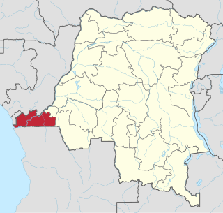
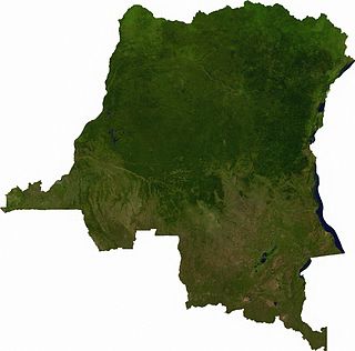
Kongo Central, formerly Bas-Congo, is one of the 26 provinces of the Democratic Republic of the Congo. Its capital is Matadi.

<span class="mw-page-title-main">Kwilu River</span> River in Democratic Republic of the Congo

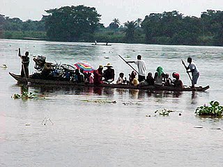
The Kwilu River is a major river in Kwilu Province, formerly known as Bandundu province, in the Democratic Republic of the Congo (DRC) to the city of Bandundu, where it joins the Kwango River just before this stream enters the Kasai River. In the DRC the river flows past the towns of Gungu, Kikwit, Bulungu, Bagata, Rutherfordia and Bandundu. Lusanga, formerly Leverville, lies at the location where the Kwenge River joins the Kwilu, between Kikwit and Bulungu.

<span class="mw-page-title-main">Bandundu (city)</span> Provincial capital and city in Kwilu, DR Congo

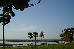
Bandundu, formerly known as Banningville or Banningstad, is the capital city of Kwilu Province of the Democratic Republic of the Congo.

<span class="mw-page-title-main">Languages of the Democratic Republic of the Congo</span>

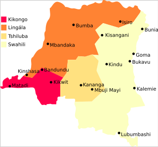
The Democratic Republic of the Congo is a multilingual country where an estimated total of 242 languages are spoken. Ethnologue lists 215 living languages. The official language, since the colonial period, is French, one of the languages of Belgium. Four other languages, three of them Bantu based, have the status of national language: Kikongo, Lingala, Swahili and Tshiluba.

Kituba is a widely used lingua franca in Central Africa. It is a creole language based on Kikongo, a Bantu language. It is a national language in Republic of the Congo and Democratic Republic of the Congo.

<span class="mw-page-title-main">Index of Democratic Republic of the Congo–related articles</span>

Articles related to the Democratic Republic of the Congo include:

<span class="mw-page-title-main">Mai-Ndombe Province</span> Province of the Democratic Republic of the Congo

Mai-Ndombe is one of the 21 new provinces of the Democratic Republic of the Congo created in the 2015 repartitioning. Mai-Ndombe, Kwango, and Kwilu provinces are the result of the dismemberment of the former Bandundu province. Mai-Ndombe was formed from the Plateaux and Mai-Ndombe districts. The town of Inongo was elevated to capital city of the new province.

<span class="mw-page-title-main">Kwango</span> Province of the Democratic Republic of the Congo

Kwango is a province of the Democratic Republic of the Congo. It's one of the 21 provinces created in the 2015 repartitioning. Kwango, Kwilu, and Mai-Ndombe provinces are the result of the dismemberment of the former Bandundu province. Kwango was formed from the Kwango district whose town of Kenge was elevated to capital city of the province.

<span class="mw-page-title-main">Kwilu Province</span> Province of the Democratic Republic of the Congo

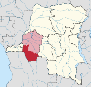
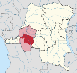
Kwilu is a province of the Democratic Republic of the Congo. It's one of the 21 provinces created in the 2015 repartitioning. Kwilu, Kwango, and Mai-Ndombe provinces are the result of the dismemberment of the former Bandundu province. Kwilu was formed from the Kwilu district and the independently administered cities of Bandundu and Kikwit. Bandundu is the provincial capital. The 2020 population was estimated to be 6,682,300.

<span class="mw-page-title-main">Mai-Ndombe District</span> Place in Bandundu, Democratic Republic of the Congo

Mai-Ndombe District was a district of pre-2015 Bandundu Province in the Democratic Republic of the Congo. It covered roughly the same area as the colonial-era Lac Léopold II District. In 2015, it was merged with Plateaux District, all in pre-2015 Bandundu Province, to form the new Mai-Ndombe Province.

<span class="mw-page-title-main">Plateaux District</span> Place in Bandundu, Democratic Republic of the Congo

The Plateaux District was a former district located in the current Mai-Ndombe Province, but until the 2015 repartitioning it was part of the former Bandundu Province.

Idiofa Territory is an administrative area in the Kwilu Province of the Democratic Republic of the Congo. The capital is the town of Idiofa.

Bagata Territory is an administrative region in the Kwilu Province of the Democratic Republic of the Congo. The headquarters are in the town of Bagata. The territory is divided into five sectors: Kidzweme, Kwango-Kasai, Kwilu-Ntobere, Manzasay and Wamba-Fatunda.

<span class="mw-page-title-main">Kwenge River</span>

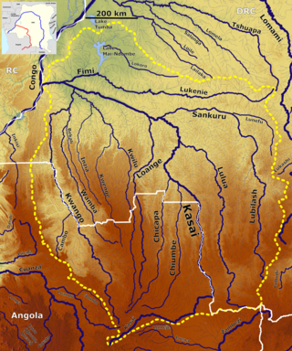
The Kwenge River is a stream in the Bandundu Province of the Democratic Republic of the Congo.

The Bunda people or in the Democratic Republic of the Congo are an ethnic group that mostly live in Idiofa Territory, Kwilu District of Bandundu Province. They speak the Mpuono language, spoken by an estimated 165,000 people as of 1972.

Vanga (vɑːɳɢ/ə/) is a town in Kwilu province in the Democratic Republic of the Congo, approximately 340 kilometres (210 mi) east of the capital city Kinshasa. Vanga is in Bulungu Territory. Vanga is known for its large medical center that supports the greater Bandundu region.

<span class="mw-page-title-main">Kwango District</span> District in Bandundu, Democratic Republic of the Congo

Kwango District was a district of the Congo Free State, Belgian Congo and the Democratic Republic of the Congo. It went through various changes in extent. It roughly corresponded to the present provinces of Kwilu and Kwango.

<span class="mw-page-title-main">Kwilu District</span> District in Bandundu, Democratic Republic of the Congo

Kwilu District was a district of the Belgian Congo and the Democratic Republic of the Congo. It roughly corresponded to the present province of Kwilu.

<span class="mw-page-title-main">Districts of the Belgian Congo</span>

The Districts of the Belgian Congo were the primary administrative divisions when Belgium annexed the Congo Free State in 1908, each administered by a district commissioner. In 1914 they were distributed among four large provinces, with some boundary changes. In 1933 the provinces were restructured into six, again with boundary changes. The number of districts fluctuated between 12 and 26 through splits and consolidations, first rising, then falling, then rising again.

References

  1. "Constitution de la République démocratique du Congo: Article 226". Wikisource.
  2. "RDC: démembrement effectif du Bandundu". Radio Okapi (in French). 19 July 2015. Archived from the original on 20 July 2015. Retrieved 4 June 2020.
  3. 1 2 "Bandundu". Congo Pages. Archived from the original on 21 September 2017. Retrieved 2 February 2012.
  4. Blaes, X. (October 2008). "Découpage administratif de la République Démocratique du Congo" (PDF). PNUD-SIG. Archived from the original (PDF) on 1 April 2010. Retrieved 9 December 2011.
  5. "Logging concession different periods" (PDF). Institute for Environmental Security. Archived from the original (PDF) on 4 March 2016. Retrieved 28 January 2012.
  6. 1 2 "Bandundu: largest cities and towns and statistics of their population". World Gazetteer. Archived from the original on 5 December 2012.
  7. 1 2 personal experience
  8. "Democratic Republic of the Congo".