
Bandundu is one of eleven former provinces of the Democratic Republic of the Congo. It bordered the provinces of Kinshasa and Bas-Congo to the west, Équateur to the north, and Kasai-Occidental to the east. The provincial capital is also called Bandundu.

Lake Mai-Ndombe is a large freshwater lake in Mai-Ndombe province in western Democratic Republic of the Congo. The lake is within the Tumba-Ngiri-Maindombe area, the largest Wetland of International Importance recognized by the Ramsar Convention in the world.

The Fimi River is a river in the Democratic Republic of the Congo. It flows from Lake Mai-Ndombe to the Kasai River, which in turn empties into the Congo. One of the Fimi's tributaries is the Lukenie River, which is navigable by barges as far as Kole.
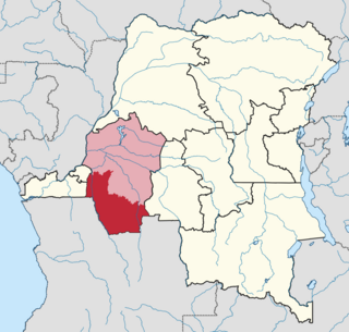
Mai-Ndombe is one of the 21 new provinces of the Democratic Republic of the Congo created in the 2015 repartitioning. Mai-Ndombe, Kwango, and Kwilu provinces are the result of the dismemberment of the former Bandundu province. Mai-Ndombe was formed from the Plateaux and Mai-Ndombe districts. The town of Inongo was elevated to capital city of the new province.

The Lukenie River is a river in the central Congo basin of the Democratic Republic of the Congo (DRC).
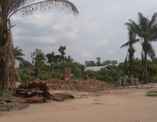
Mushie is a town in Mai-Ndombe province, Democratic Republic of the Congo and is the administrative center of Mushie Territory. It lies at an elevation of 1118 ft, on the northern bank of the Kasai River at its confluence with the Fimi River. Mushie's population is roughly 33,000. Mushie was the birthplace of the celebrated Congolese musician Papa Wendo. The town is served by Mushie Airport.
Yumbi is a town and territory of Mai-Ndombe in the Democratic Republic of the Congo. It lies on the eastern bank of the Congo River between Bolobo and Lukolela. The town of Yumbi is the headquarters of Yumbi Territory and has a population of approximately 30,000.

Kwilu is a province of the Democratic Republic of the Congo. It's one of the 21 provinces created in the 2015 repartitioning. Kwilu, Kwango, and Mai-Ndombe provinces are the result of the dismemberment of the former Bandundu province. Kwilu was formed from the Kwilu district and the independently administered cities of Bandundu and Kikwit. Bandundu is the provincial capital.

Mai-Ndombe District was a district of pre-2015 Bandundu Province in the Democratic Republic of the Congo. It covered roughly the same area as the colonial-era Lac Léopold II District. In 2015, it was merged with Plateaux District, all in pre-2015 Bandundu Province, to form the new Mai-Ndombe Province.
Tolo is a town on the Lukenie River in Kutu territory of Mai-Ndombe province of the Democratic Republic of the Congo. It was founded as a colonial post by Alexandre Delcommune around 1887.
Nioki is a town and community in Mai-Ndombe province of the Democratic Republic of the Congo, on the Fimi River. It was founded as a colonial post by Alexandre Delcommune around 1887.
Bolobo Territory is an administrative region of Mai-Ndombe Province of the Democratic Republic of the Congo. The headquarters is the town of Bolobo. The territory lies on the east side of the Congo River, opposite the Republic of the Congo.
Kwamouth is a small community in Mai-Ndombe province in the Democratic Republic of the Congo. It is the headquarters of the Kwamouth territory. The town lies at the mouth of the Kwah River, the last stretch of the Kasai River after it has been joined by the Fimi River, where it enters the Congo River.
Kiri Territory is an administrative region of Mai-Ndombe Province, Democratic Republic of the Congo. The headquarters is the town of Kiri.
The Lokoro River is a river in the Democratic Republic of the Congo, one of the largest affluents of Lake Mai-Ndombe.
Djokele Airport is an airport serving Djokele, a village on the Fimi River in Mai-Ndombe Province, Democratic Republic of the Congo.
Kempile Airport is an airport serving the Fimi River town of Kutu in Mai-Ndombe Province, Democratic Republic of the Congo. The runway is 4 kilometres (2.5 mi) west of Kutu, by the village of Kempile.
Kwango District was a district of the Congo Free State, Belgian Congo and the Democratic Republic of the Congo. It went through various changes in extent. It roughly corresponded to the present provinces of Kwilu and Kwango.

Lac Léopold II District was a district of the Congo Free State, Belgian Congo and Democratic Republic of the Congo. It went through various changes in extent, but roughly corresponded to the modern Mai-Ndombe Province.
