Kwango District

Last updated
Kwango District
District
DRC Bandundu Kwango.png
Kwango district of Bandundu province (2014)
Coordinates: 5°17′56″S16°25′30″E / 5.299°S 16.425°E / -5.299; 16.425 Coordinates: 5°17′56″S16°25′30″E / 5.299°S 16.425°E / -5.299; 16.425
CountryDemocratic Republic of the Congo
Province Bandundu
District Kwango

Kwango District (French : District du Kwango, Dutch : District Kwango) was a district of the Congo Free State, Belgian Congo and the Democratic Republic of the Congo. It went through various changes in extent. It roughly corresponded to the present provinces of Kwilu and Kwango.

Contents

Congo Free State

In 1895 the number of the districts in the Congo Free State was increased to fifteen. The districts now included Kwango District. [1] It had been carved out of the west of the Kasai District. [2] A map of the Congo Free State in 1897 shows the Kwango Oriental district bounded by the Stanley Pool District to the west, the Lualaba Kassai District to the east, and Portuguese possessions (Angola) to the south. [3] The district extended south from the point where the combined Kwango and Kwilu rivers entered the Kasai River, and included the watershed of the Wamba River. The Kwango River formed the border with the Portuguese territory to the west, and the eastern boundary was to the east of the Kwilu River. [3]

Belgian Congo

The Congo Free State was annexed by Belgium in 1908 as the Belgian Congo. Kwango is shown with slightly different boundaries in maps of 1910, 1912, 1926 and 1933. In 1910 Kwango bordered Bas-Congo to the west, Moyen-Congo to the northwest, Lac Léopold II to the northeast and Kasai to the east. [2]

Congo-Kasai formally become a vice-government in 1919. [4] It contained the districts of Bas-Congo, Léopoldville, Kwango, Kasai and Sankuru. [2] With the 1933 reorganization Bas-Congo, Léopoldville, Kwango and Lac Léopold II were included in the Léopoldville Province. [2] A map from 1955-1957 showed a much smaller Kwango District after the northern part had been made into Kwilu District. Kwango was now bordered by the Portuguese territories to the south, Cataractes District to the west, Kwilu District to the north and Kasai District to the east. [5] The area was 93,300 square kilometres (36,000 sq mi) out of a total of 357,700 square kilometres (138,100 sq mi) for Léopoldville province as a whole. [6]

Post-independence

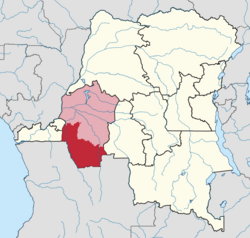
Léopoldville Province was divided in 1963–1966 into the provinces of Congo Central, Kwilu, Kwango, and Mai-Ndombe. Bandundu Province was formed in 1966 by merging Kwilu, Kwango and Mai-Ndombe. [7] As of 2008 Kwango District contained the territories of Kenge, Popokabaka, Feshi, Kasongo-Lunda and Kahemba. [8] In 2015 Kwango Province was formed from the Kwango district, whose town of Kenge was elevated to capital city of the new province.

Maps

See also

Related Research Articles

Bandundu Province Province in Democratic Republic of the Congo

Bandundu is one of eleven former provinces of the Democratic Republic of the Congo. It bordered the provinces of Kinshasa and Bas-Congo to the west, Équateur to the north, and Kasai-Occidental to the east. The provincial capital is also called Bandundu.

Lualaba District District in Katanga, Democratic Republic of the Congo

Lualaba District was a district of the pre-2015 Katanga Province in the Democratic Republic of the Congo. The district dates back to the days of the Congo Free State and the Belgian Congo. The original Lualaba District was merged into Katanga in 1910, but in 1933 a new Lualaba District was formed within Katanga. After various significant boundary changes, in 2015 the district became the western part of the present Lualaba Province.

Lulua District District in Kasai-Occidental, Democratic Republic of the Congo

Lulua District was a district of the Belgian Congo and the Democratic Republic of the Congo. The city of Kananga was at the center of the district, but had a separate administration. In 2015 Lulua District became the province of Kasaï-Central.

Équateur District District in Équateur Province, Democratic Republic of the Congo

Équateur District was a former district of the Congo Free State, Belgian Congo and Democratic Republic of the Congo. In 1914 it became part of former Équateur Province. The district went through various changes of extent and name over the years. The original district roughly corresponds to the current provinces of Équateur and Tshuapa.

Cataractes District District in Kongo Central, Democratic Republic of the Congo

Cataractes District was a district located in the Kongo Central province, in the Democratic Republic of the Congo. It dated back to the days of the Congo Free State and the Belgian Congo.

Kwango Province of the Democratic Republic of the Congo

Kwango is one of the 21 new provinces of the Democratic Republic of the Congo created in the 2015 repartitioning. Kwango, Kwilu, and Mai-Ndombe provinces are the result of the dismemberment of the former Bandundu province. Kwango was formed from the Kwango district whose town of Kenge was elevated to capital city of the new province.

Kasai District District in Kasaï, Democratic Republic of the Congo

Kasai District was a district of the Congo Free State, Belgian Congo and the Democratic Republic of the Congo, named after the Kasai River. It was formed around 1885 and went through several large changes in extent in the years that followed. The 1933 version of the district roughly corresponded to the former Kasai-Occidental province and the present Kasaï and Kasaï-Central provinces.

Kwilu District District in Bandundu, Democratic Republic of the Congo

Kwilu District was a district of the Belgian Congo and the Democratic Republic of the Congo. It roughly corresponded to the present province of Kwilu.

Barthélemy Mukenge Nsumpi Shabantu was a Congolese politician who served as President of Kasaï Province from 11 June 1960 to January 1962 and July to September 1962. He was a president of the Association des Lulua-Frères, a Lulua ethnic syndicate, and a leading member of the Union National Congolaise. Though initially allied with nationalist Patrice Lumumba, he later denounced him and aligned himself with more moderate politicians. Following the division of Kasai Province in late 1962, Mukenge became Minister of Health and Minister of Social Affairs of the new Luluabourg Province. He later served as Governor of Kivu Province and on the Political Bureau of the Mouvement Populaire de la Révolution. He withdrew from politics in 1974 and died in 2018.

Districts of the Belgian Congo

The Districts of the Belgian Congo were the primary administrative divisions when Belgium annexed the Congo Free State in 1908, each administered by a district commissioner. In 1914 they were distributed among four large provinces, with some boundary changes. In 1933 the provinces were restructured into six, again with boundary changes. The number of districts fluctuated between 12 and 26 through splits and consolidations, first rising, then falling, then rising again.

Lac Léopold II District District in Équateur, Belgian Congo

Lac Léopold II District was a district of the Congo Free State, Belgian Congo and Democratic Republic of the Congo. It went through various changes in extent, but roughly corresponded to the modern Mai-Ndombe Province.

Aruwimi District District in Orientale, Belgian Congo

Aruwimi District was a district of the Congo Free State and Belgian Congo. It went through various changes in extent before being absorbed into other districts.

Stanleyville District District in Orientale, Democratic Republic of the Congo

Stanleyville District was a district of the Belgian Congo and Democratic Republic of the Congo. It went through various changes in extent. Between 1933 and 1963 it had roughly the same extent as the current Tshopo province.

Uele District District in Orientale, Belgian Congo

Uele District was a district of the Congo Free State and the Belgian Congo. It roughly corresponded to the current provinces of Bas-Uélé and Haut-Uélé.

Ubangi District District in Équateur, Belgian Congo

Ubangi District was a district of the Congo Free State, Belgian Congo and Democratic Republic of the Congo. It went through various significant changes in extent.

Bangala District District in Orientale, Belgian Congo

Bangala District was a district of the Congo Free State and the Belgian Congo. It went through various significant changes in extent. The eastern part very roughly corresponded to the present province of Mongala.

Bas-Congo District District in Democratic Republic of the Congo

Bas-Congo was a district of the Belgian Congo and the Democratic Republic of the Congo. It went through various significant changes in extent. It roughly corresponds to the present province of Kongo Central.

Stanley Falls District District in Belgian Congo

Stanley Falls District was a district of the Congo Free State. It covered most of the eastern part of the colony along the Congo River south from Stanleyville.

Stanley Pool District District in Stanley Pool, Belgian Congo

Stanley Pool District, later named Moyen-Congo District was a district of the Congo Free State and Belgian Congo. It disappeared in a reorganization of 1914.

Districts of the Congo Free State

The Districts of the Congo Free State were the primary administrative divisions of the Congo Free State from 1885 to 1908. There were various boundary changes in the period before the Congo Free State was annexed by Belgium to become the Belgian Congo.

References

  1. Omasombo Tshonda 2014, p. 211.
  2. 1 2 3 4 Atlas général du Congo.
  3. 1 2 Omasombo Tshonda 2015, p. 16.
  4. Lemarchand 1964, p. 64.
  5. Brass 2015, p. 243.
  6. Brass 2015, p. 254.
  7. Congo (Kinshasa) Provinces.
  8. Blaes 2008.

Sources