
Angola, officially the Republic of Angola, is a country on the west-central coast of Southern Africa. It is the second-largest Lusophone (Portuguese-speaking) country in both total area and population and is the seventh-largest country in Africa. It is bordered by Namibia to the south, the Democratic Republic of the Congo to the north, Zambia to the east, and the Atlantic Ocean to the west. Angola has an exclave province, the province of Cabinda, that borders the Republic of the Congo and the Democratic Republic of the Congo. The capital and most populous city is Luanda.

The Islamabad Capital Territory is the only federal territory of Pakistan containing Islamabad, the capital of Pakistan. Located on the northern edge of the Pothohar Plateau and at the foot of the Margalla Hills, The ICT shares borders with the province of Khyber Pakhtunkhwa in the west and with the province of Punjab in the remaining directions. It covers an area of 1,165 square kilometres and according to the 2023 national census, has a population of over 1 million in the city proper, while over 2 million in the whole territory. The territory is represented in the National Assembly by NA-52, NA-53, and NA-54 constituencies and by four seats in the Senate.

The Democratic Republic of the Congo, also known as Congo-Kinshasa, DRC, DR Congo, or simply the Congo and known from 1971–1997 as Zaire, is a country in Central Africa. By land area, the DRC is the second-largest country in Africa and the 11th-largest in the world. With a population of around 112 million, the Democratic Republic of the Congo is the most populous officially Francophone country in the world. The national capital and largest city is Kinshasa, which is also the economic center. The country is bordered by the Republic of the Congo, Central African Republic, South Sudan, Uganda, Rwanda, Burundi, Tanzania, Zambia, Angola, the Cabinda exclave of Angola and the South Atlantic Ocean.

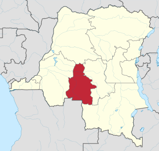
Zaire is one of the 18 provinces of Angola. It occupies 40,130 square kilometres (15,490 sq mi) in the north west of the country and had a population of 594,428 inhabitants in 2014. It is bordered on the west by the Atlantic Ocean, on the north by the Democratic Republic of Congo, on the east by the Uíge Province, and on the south by the Bengo Province.
Kasaï-Occidental was one of the eleven provinces of the Democratic Republic of the Congo between 1966 and 2015, when it was split into the Kasaï-Central and the Kasaï provinces.

The Third Republic of the Democratic Republic of the Congo is a unitary state with a five-level hierarchy of types of administrative division. There are nine different types of country subdivision in a new hierarchy with no new types but with two from the previous one abolished.

The territories of the Democratic Republic of the Congo are administrative divisions of provinces. Territories are further divided into sectors, chiefdoms, and communes. They are led by an administrator and, for the most part, take the name of the town that is their administrative center.

The National Assembly is the lower house and main legislative political body of the Parliament of the Democratic Republic of the Congo. It is one of the two legislative bodies along with the Senate. The National Assembly is composed of deputies who are elected by the citizens of the DRC. The deputies serve as the voice of the people and are responsible for enacting legislation, representing their constituents' interests, and overseeing the executive branch of government. The National Assembly is responsible for deliberating and passing laws that impact the nation and its citizens. It was established by the 2006 constitution, which provided for a bicameral parliament consisting of the National Assembly and the Senate. It is located at the People's Palace in Kinshasa.

Masisi Territory is a territory which is located within the North Kivu Province of the Democratic Republic of the Congo. Its political headquarters are located in the town of Masisi.
Griffith Island lies within the Arctic Archipelago in the Qikiqtaaluk Region of northern Canada's territory of Nunavut. It is one of the mid-channel islands in the western sector of Barrow Strait.

The Republic of the Congo, also known as Congo-Brazzaville, the Congo Republic or simply either Congo or the Congo, is a country located on the western coast of Central Africa to the west of the Congo River. It is bordered to the west by Gabon, to its northwest by Cameroon and its northeast by the Central African Republic, to the southeast by the Democratic Republic of the Congo, to its south by the Angolan exclave of Cabinda and to its southwest by the Atlantic Ocean.
Kasongo Lunda is a territory in the Democratic Republic of Congo, located in Kwango Province. The capital lies at Kasongo Lunda. It is the second biggest territory in Congo, located near to the border with Angola.
Kahemba is a territory of the Democratic Republic of the Congo. It is located in Kwango Province. Divisions are:
Popokabaka Territory is a territory of the Democratic Republic of the Congo. It is located in the Kwango province. The territory is divided into three sectors: Yonso, Popokabaka and Lufuna. The Kwango River runs through the territory. The administrative center is the city of Popokabaka.

Aketi Territory is a territory in the Bas-Uele Province of the Democratic Republic of the Congo. The administrative capital is located at Aketi. The territory borders Bondo Territory to the north, Buta Territory to the east, Basoko Territory to the south, Bumba Territory to the west in Mongala Province and Yakoma Territory in Nord-Ubangi Province to the northwest. Rivers include the Likati River, Zoki River, Maze River, Tinda River, Tshimbi River, Elongo River, Aketi River, Yoko River and Lese River along the southern territorial border.
Kilwa is a town, headquarters of Moero Sector, Pweto Territory, Haut-Katanga Province of the Democratic Republic of the Congo (DRC).

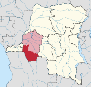
Kwango is a province of the Democratic Republic of the Congo. It's one of the 21 provinces created in the 2015 repartitioning. Kwango, Kwilu, and Mai-Ndombe provinces are the result of the dismemberment of the former Bandundu province. Kwango was formed from the Kwango district whose town of Kenge was elevated to capital city of the province.
MadimbaTerritory is a territory in the Kongo Central Province of the Democratic Republic of the Congo (DRC). Its seat is the town of Madimba. The region covers an area of 8,260 square miles and is situated 100 km from Kinshasa. It spans from the Lukusu River in the north to Kintano in the west, and from the Inkisi River in the west to Kinkosi-Luidi in the southeast. The territory borders Kasangulu Territory to the northeast, Kimvula Territory to the southeast, Mbanza-Ngungu Territory to the west, and Angola to the south. Madimba Territory is home to an approximate population of 463,132 residents.
Inongo Territory is a second-level administrative area (territory) in Maï-Ndombe Province in the Democratic Republic of the Congo. Its headquarters is in the provincial capital of Inongo.
Kwango District was a district of the Congo Free State, Belgian Congo and the Democratic Republic of the Congo. It went through various changes in extent. It roughly corresponded to the present provinces of Kwilu and Kwango.