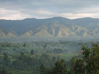
North Kivu is a province bordering Lake Kivu in the eastern Democratic Republic of the Congo. The capital city is Goma. Spanning approximately 59,483 square kilometers with a population estimate of 8,147,400 as of 2020, it is bordered by Ituri Province to the north, Tshopo Province to the northwest, Maniema Province to the southwest, and South Kivu Province to the south, as well as Uganda and Rwanda to the east.

South Kivu is one of 26 provinces of the Democratic Republic of the Congo (DRC). Its capital is Bukavu.

The Third Republic of the Democratic Republic of the Congo is a unitary state with a five-level hierarchy of types of administrative division. There are nine different types of country subdivision in a new hierarchy with no new types but with two from the previous one abolished.

The territories of the Democratic Republic of the Congo are administrative divisions of provinces. Territories are further divided into sectors, chiefdoms, and communes. They are led by an administrator and, for the most part, take the name of the town that is their administrative center.

Masisi Territory is a territory which is located within the North Kivu Province of the Democratic Republic of the Congo. Its political headquarters are located in the town of Masisi.
Kasongo Lunda is a territory in the Democratic Republic of Congo, located in Kwango Province. The capital lies at Kasongo Lunda. It is the second biggest territory in Congo, located near to the border with Angola.
Opala is a territory in the Tshopo Province of the Democratic Republic of the Congo.

Mambasa Territory is an administrative area in the Ituri Province of the Democratic Republic of the Congo. The headquarters is in the town of Mambasa. Mambasa Territory is threatened with deforestation due to illegal forestry to meet high demand for lumber by the bordering countries of Rwanda, Uganda, Burundi and Kenya, as well as to slash and burn cultivation and growing demand for fuel-wood by large numbers of immigrants from the east.
Wamba Territory is a part of the Haut-Uele province of the Democratic Republic of the Congo. The administrative center is the town of Wamba.
Niangara Territory is an administrative region in the Haut-Uele province of the Democratic Republic of the Congo. Its headquarters is the town of Niangara, lying on both sides of the Uele River.
Watsa Territory is an administrative area in the Haut-Uélé province of the Democratic Republic of the Congo. The administrative center is the town of Watsa.

Pweto Territory is a territory in the Haut-Katanga Province of the Democratic Republic of the Congo (DRC). The headquarters are in the town of Pweto.

In the Democratic Republic of the Congo, chiefdoms and sectors are rural administrative divisions of territories. They are further subdivided into groupings which themselves are divided into villages. Chiefdoms and groupings are led by traditional leaders officially recognized by the government, whereas sector chiefs are appointed directly by the government.

Aketi Territory is a territory in the Bas-Uele Province of the Democratic Republic of the Congo. The administrative capital is located at Aketi. The territory borders Bondo Territory to the north, Buta Territory to the east, Basoko Territory to the south, Bumba Territory to the west in Mongala Province and Yakoma Territory in Nord-Ubangi Province to the northwest. Rivers include the Likati River, Zoki River, Maze River, Tinda River, Tshimbi River, Elongo River, Aketi River, Yoko River and Lese River along the southern territorial border.
Bondo Territory is a territory in the Bas-Uele Province of the Democratic Republic of the Congo. The administrative capital is the town of Bondo.
Buta Territory is a territory in Bas-Uele District, Orientale Province, Democratic Republic of the Congo. The administrative capital is located at Buta.
Moba Territory is a territory in the Tanganyika Province of the Democratic Republic of the Congo. The administrative center is Moba port. The territory has an estimated area of 24,500 square kilometres (9,500 sq mi) and a population of almost 610,000.
Pangi Territory is an administrative area in Maniema Province of the Democratic Republic of the Congo. The headquarters is the town of Pangi.
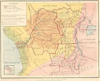
Congo-Kasaï was one of the four large provinces of the Belgian Congo defined in 1914. It was formally established in 1919, and in 1933 was divided into the new provinces of Léopoldville and Lusambo.

The Districts of the Belgian Congo were the primary administrative divisions when Belgium annexed the Congo Free State in 1908, each administered by a district commissioner. In 1914 they were distributed among four large provinces, with some boundary changes. In 1933 the provinces were restructured into six, again with boundary changes. The number of districts fluctuated between 12 and 26 through splits and consolidations, first rising, then falling, then rising again.
