
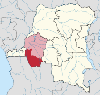
Bandundu is one of eleven former provinces of the Democratic Republic of the Congo. It bordered the provinces of Kinshasa and Bas-Congo to the west, Équateur to the north, and Kasai-Occidental to the east. The provincial capital is also called Bandundu.
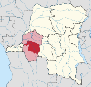
Mai-Ndombe is one of the 21 new provinces of the Democratic Republic of the Congo created in the 2015 repartitioning. Mai-Ndombe, Kwango, and Kwilu provinces are the result of the dismemberment of the former Bandundu province. Mai-Ndombe was formed from the Plateaux and Mai-Ndombe districts. The town of Inongo was elevated to capital city of the new province.
Bolobo is a town on the Congo River in Mai-Ndombe Province in the western part of the Democratic Republic of the Congo (DRC). It is the administrative center of Bolobo Territory. As of 2009 it had an estimated population of 31,366.
Yumbi is a town and territory of Mai-Ndombe in the Democratic Republic of the Congo. It lies on the eastern bank of the Congo River between Bolobo and Lukolela. The town of Yumbi is the headquarters of Yumbi Territory and has a population of approximately 30,000.

Pweto Territory is a territory in the Haut-Katanga Province of the Democratic Republic of the Congo (DRC). The headquarters are in the town of Pweto.
Opala is a town in the Tshopo Province of the Democratic Republic of the Congo. It is the administrative center of the Opala Sector and of the Opala Territory. The town lies on the left bank of the Lomami River.

Kwango is a province of the Democratic Republic of the Congo. It's one of the 21 provinces created in the 2015 repartitioning. Kwango, Kwilu, and Mai-Ndombe provinces are the result of the dismemberment of the former Bandundu province. Kwango was formed from the Kwango district whose town of Kenge was elevated to capital city of the province.

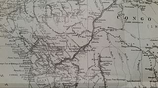
Mai-Ndombe District was a district of pre-2015 Bandundu Province in the Democratic Republic of the Congo. It covered roughly the same area as the colonial-era Lac Léopold II District. In 2015, it was merged with Plateaux District, all in pre-2015 Bandundu Province, to form the new Mai-Ndombe Province.

The Plateaux District was a former district located in the current Mai-Ndombe Province, until no later than February 2009. However, the change was not implemented until 2015, and until then it was part of the Bandundu Province.
Dekese is a community in the Democratic Republic of the Congo, on the right bank of the Lukenie River. It is the administrative center of the Dekese territory of Kasai province.
Bolobo Territory is an administrative region of Mai-Ndombe Province of the Democratic Republic of the Congo. The headquarters is the town of Bolobo. The territory lies on the east side of the Congo River, opposite the Republic of the Congo.
Idiofa Territory is an administrative area in the Kwilu Province of the Democratic Republic of the Congo. The capital is the town of Idiofa.
Oshwe is a community in Mai-Ndombe province, Democratic Republic of the Congo (DRC). It is the headquarters of Oshwe territory. The town lies on the Lukenie River. The estimated population as of 2012 was 22,576. The town is served by Oshwe Airport at an elevation of 1,150 feet (350 m).
Kwamouth is a small community in Mai-Ndombe province in the Democratic Republic of the Congo. It is the headquarters of the Kwamouth territory. The town lies at the mouth of the Kwah River, the last stretch of the Kasai River after it has been joined by the Fimi River, where it enters the Congo River.
Kiri is a town in Mai-Ndombe Province, Democratic Republic of the Congo. It is the headquarters of Kiri Territory. As of 2012 the estimated population was 14,612. The town is served by a small airport, Basango Mboliasa Airport, at an elevation of 309 metres (1,013 ft).
The Lokoro River is a river in the Democratic Republic of the Congo, one of the largest affluents of Lake Mai-Ndombe.
Kwango District was a district of the Congo Free State, Belgian Congo and the Democratic Republic of the Congo. It went through various changes in extent. It roughly corresponded to the present provinces of Kwilu and Kwango.
Kwilu District was a district of the Belgian Congo and the Democratic Republic of the Congo. It roughly corresponded to the present province of Kwilu.

The Districts of the Belgian Congo were the primary administrative divisions when Belgium annexed the Congo Free State in 1908, each administered by a district commissioner. In 1914 they were distributed among four large provinces, with some boundary changes. In 1933 the provinces were restructured into six, again with boundary changes. The number of districts fluctuated between 12 and 26 through splits and consolidations, first rising, then falling, then rising again.

Lac Léopold II District was a district of the Congo Free State, Belgian Congo and Democratic Republic of the Congo. It went through various changes in extent, but roughly corresponded to the modern Mai-Ndombe Province.
