Related Research Articles

The Congo River, formerly also known as the Zaire River, is the second-longest river in Africa, shorter only than the Nile, as well as the third largest river in the world by discharge volume, following the Amazon and the Ganges rivers. It is also the world's deepest recorded river, with measured depths of around 220 m (720 ft). The Congo-Lualaba-Chambeshi River system has an overall length of 4,700 km (2,900 mi), which makes it the world's ninth-longest river. The Chambeshi is a tributary of the Lualaba River, and Lualaba is the name of the Congo River upstream of Boyoma Falls, extending for 1,800 km (1,100 mi).

Bandundu is one of eleven former provinces of the Democratic Republic of the Congo. It bordered the provinces of Kinshasa and Bas-Congo to the west, Équateur to the north, and Kasai-Occidental to the east. The provincial capital is also called Bandundu.

Lake Mai-Ndombe is a large freshwater lake in Mai-Ndombe province in western Democratic Republic of the Congo. The lake is within the Tumba-Ngiri-Maindombe area, the largest Wetland of International Importance recognized by the Ramsar Convention in the world.

A blackwater river is a type of river with a slow-moving channel flowing through forested swamps or wetlands. Most major blackwater rivers are in the Amazon Basin and the Southern United States. The term is used in fluvial studies, geology, geography, ecology, and biology. Not all dark rivers are blackwater in that technical sense. Some rivers in temperate regions, which drain or flow through areas of dark black loam, are simply black due to the color of the soil; these rivers are black mud rivers. There are also black mud estuaries.

Salonga National Park is a national park in the Democratic Republic of the Congo located in the Congo River basin. It is Africa's largest tropical rainforest reserve covering about 36,000 km2 or 3,600,000 hectares. It extends into the provinces of Mai Ndombe, Equateur, Kasaï and Sankuru. In 1984, the national park was inscribed on the UNESCO World Heritage List for its protection of a large swath of relatively intact rainforest and its important habitat for many rare species. In 1999, the site has been listed as endangered due to poaching and housing construction. Following the improvement in its state of conservation, the site was removed from the endangered list in 2021.

Lake Tumba is a shallow lake in northwestern part of the Democratic Republic of the Congo, in the Bikoro Territory of the Province of Équateur.
Semliki River is a major river, 140 kilometres (87 mi) long, in the Democratic Republic of the Congo (DRC) and Uganda in Central and East Africa. It flows north from Lake Edward in Beni Territory, Nord-Kivu, D.R.C avoiding the Rwenzori Mountains on its Right (East), emptying into Lake Albert in the Albertine Rift, Irumu Territory, Ituri Province, D.R.C overlooking the Blue Mountains to its left in the west. Its mouth is near the Village of Katolingo in Kanara subcounty, Ntoroko district, Uganda. Along its lower reaches, it meanders extensively forming part of the international border between the DRC and the western Ugandan districts of Bundibugyo and Ntoroko, near the Semuliki National Park.

The wildlife of the Democratic Republic of the Congo includes its flora and fauna, comprising a large biodiversity in rainforests, seasonally flooded forests and grasslands.


The Twa are a group of indigenous African Pygmy tribes.

Pweto Territory is a territory in the Haut-Katanga Province of the Democratic Republic of the Congo (DRC). The headquarters are in the town of Pweto.

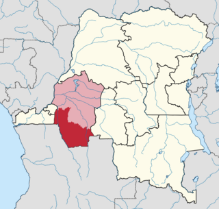
Mai-Ndombe District was a district of pre-2015 Bandundu Province in the Democratic Republic of the Congo. It covered roughly the same area as the colonial-era Lac Léopold II District. In 2015, it was merged with Plateaux District, all in pre-2015 Bandundu Province, to form the new Mai-Ndombe Province.

The Plateaux District was a former district located in the current Mai-Ndombe Province, but until the 2015 repartitioning it was part of the former Bandundu Province.

The Rutshuru River is a river in the eastern Democratic Republic of the Congo that drains Lake Mutanda in the foothills of the Virunga Mountains in Uganda, flowing northward into Lake Rutanzige. For most of its length it runs through the Rutshuru Territory in North Kivu province.
Tumba-Ngiri-Maindombe is the largest Wetland of International Importance in the world as recognized by the Ramsar Convention. The site covers an area of 65,696 square kilometres (25,365 sq mi) in the region around Lake Tumba in the western Congo Basin in the Democratic Republic of the Congo (DRC). This is more than twice the size of Belgium or Maryland.
Kiri Territory is an administrative region of Mai-Ndombe Province, Democratic Republic of the Congo. The headquarters is the town of Kiri.
Iyaelima people are an ethnic group with a population of about 2,500 that live in eight settlements in the southern part of the Salonga National Park (SNP) in the Democratic Republic of the Congo. They belong to the Mongo group of Bantu peoples. Although they practice slash-and-burn agriculture and hunt for bushmeat, they have little impact on the environment. The Iyaelima never kill bonobos, an ape closely related to humans whose population is much higher in Iyaelima territory than elsewhere.
Kwango District was a district of the Congo Free State, Belgian Congo and the Democratic Republic of the Congo. It went through various changes in extent. It roughly corresponded to the present provinces of Kwilu and Kwango.

Lac Léopold II District was a district of the Congo Free State, Belgian Congo and Democratic Republic of the Congo. It went through various changes in extent, but roughly corresponded to the modern Mai-Ndombe Province.
References
- ↑ Blaes 2008.
- ↑ Thieme 2005, p. 195.
- ↑ Vansina 1990, p. 121.
- ↑ Furuichi & Thompson 2008, p. 230.