Bandundu (city)

Last updated
Bandundu
Provincial capital and city
Ville de Bandundu
Bandundu Centre, vue aerienne.jpg
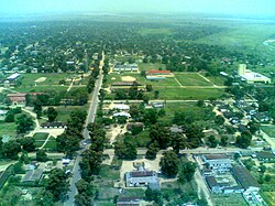
View of city center from the air, 2007
Democratic Republic of the Congo adm location map.svg
Red pog.svg
Bandundu
Location in Democratic Republic of the Congo
Coordinates: 3°19′S17°22′E / 3.317°S 17.367°E / -3.317; 17.367
Country Flag of the Democratic Republic of the Congo.svg DR Congo
Province Kwilu
City status 1969
CommunesBasoko, Disasi, Mayoyo
Government
  MayorMoïse Monshengo [1] [2]
Area
  Total222 km2 (86 sq mi)
Elevation
321 m (1,053 ft)
Population
 (2012)
  Total143,435
  Density650/km2 (1,700/sq mi)
Time zone UTC+1 (West Africa Time)
Climate Aw

Bandundu, formerly known as Banningville or Banningstad, is the capital city of Kwilu Province of the Democratic Republic of the Congo. [3]

Contents

Location

Bandundu is located on the east bank of the Kwango River, just north of the confluence of the Kwango and the Kwilu, and 8 kilometres (5.0 mi) south from the mouth of the Kwango on the Kasai River. It is around 260 kilometres (160 mi) from Kinshasa by air, or about 400 kilometres (250 mi) by road. In 2009, Bandundu had an estimated population of 133,080. [4]

Economy

Bandundu was once a significant river port, as it is the largest town on the river between Kinshasa and Kikwit. However, traffic on the Kasai and Kwango Rivers dropped dramatically as a result of the Second Congo War, and has yet to recover. Bandundu does have intermittent passenger and freight service to Kinshasa, Mushie and Kikwit. Since 2008, there is a car/truck ferry service running several times per day across the Kwango. An unpaved road, roughly 250 km long, runs from this point to the main (paved) highway between Kinshasa and Kikwit.

Bandundu is served by Bandundu Airport, with direct flights to Kinshasa.

Unlike many cities in the Congo, Bandundu has a fairly constant supply of electricity. However, this has nothing to do with Inga-Shaba HVDC line, as this line has no intermediate terminals.[ citation needed ]

Climate

Under the Köppen climate classification, Bandundu has a tropical wet and dry climate (Aw). [5]

Climate data for Bandundu
MonthJanFebMarAprMayJunJulAugSepOctNovDecYear
Record high °C (°F)37.0
(98.6)
35.6
(96.1)
36.5
(97.7)
35.5
(95.9)
35.3
(95.5)
34.2
(93.6)
33.3
(91.9)
35.4
(95.7)
35.2
(95.4)
34.8
(94.6)
34.4
(93.9)
33.9
(93.0)
37.0
(98.6)
Mean daily maximum °C (°F)30.6
(87.1)
31.1
(88.0)
31.4
(88.5)
31.4
(88.5)
31.3
(88.3)
30.6
(87.1)
29.5
(85.1)
30.7
(87.3)
31.0
(87.8)
31.0
(87.8)
30.5
(86.9)
30.3
(86.5)
30.8
(87.4)
Daily mean °C (°F)26.2
(79.2)
26.5
(79.7)
26.6
(79.9)
26.7
(80.1)
26.7
(80.1)
25.6
(78.1)
24.5
(76.1)
25.5
(77.9)
26.1
(79.0)
26.3
(79.3)
26.0
(78.8)
26.1
(79.0)
26.1
(79.0)
Mean daily minimum °C (°F)21.8
(71.2)
21.9
(71.4)
21.8
(71.2)
22.0
(71.6)
22.1
(71.8)
20.6
(69.1)
19.5
(67.1)
20.3
(68.5)
21.2
(70.2)
21.6
(70.9)
21.5
(70.7)
21.9
(71.4)
21.4
(70.5)
Record low °C (°F)17.9
(64.2)
18.2
(64.8)
18.6
(65.5)
18.6
(65.5)
17.0
(62.6)
15.8
(60.4)
15.0
(59.0)
15.0
(59.0)
18.6
(65.5)
18.5
(65.3)
18.7
(65.7)
17.8
(64.0)
15.0
(59.0)
Average precipitation mm (inches)144
(5.7)
149
(5.9)
169
(6.7)
171
(6.7)
100
(3.9)
23
(0.9)
6
(0.2)
22
(0.9)
107
(4.2)
213
(8.4)
246
(9.7)
192
(7.6)
1,542
(60.7)
Average precipitation days (≥ 0.1 mm)796862128810975
Source: Deutscher Wetterdienst [6]

Sister cities

See also

Related Research Articles

<span class="mw-page-title-main">Bandundu Province</span> Province in Democratic Republic of the Congo

Bandundu is one of eleven former provinces of the Democratic Republic of the Congo. It bordered the provinces of Kinshasa and Bas-Congo to the west, Équateur to the north, and Kasai-Occidental to the east. The provincial capital is also called Bandundu.

<span class="mw-page-title-main">Kwilu River</span> River in Democratic Republic of the Congo

The Kwilu River is a major river in Kwilu Province, formerly known as Bandundu province, in the Democratic Republic of the Congo (DRC) to the city of Bandundu, where it joins the Kwango River just before this stream enters the Kasai River. In the DRC the river flows past the towns of Gungu, Kikwit, Bulungu, Bagata, Rutherfordia and Bandundu. Lusanga, formerly Leverville, lies at the location where the Kwenge River joins the Kwilu, between Kikwit and Bulungu.

<span class="mw-page-title-main">Kikwit</span> City in Kwilu Province, DR Congo

Kikwit is the largest city of Kwilu Province, lying on the Kwilu River in the southwestern part of the Democratic Republic of the Congo. Kikwit is also known in the region under the nickname "The Mother". The population is approximately 458,000 (2017). An important commercial centre, it is home to a stadium and is known for its traditional dances, in particular the Bapende dancers whose geographic origin centers on the village of Gungu. Bapende dancers often wear traditional costumes comprising colorful masks and attire made from raffia.

Kituba is a widely used lingua franca in Central Africa. It is a creole language based on Kikongo, a Bantu language. It is a national language in Republic of the Congo and Democratic Republic of the Congo.

<span class="mw-page-title-main">Index of Democratic Republic of the Congo–related articles</span>

Articles related to the Democratic Republic of the Congo include:

Bandundu Airport is an airport serving Bandundu, capital of the Kwilu Province in the Democratic Republic of the Congo.

<span class="mw-page-title-main">Kwango River</span> River in Central Africa; forms part of the border between Angola and the DRC

The Cuango or Kwango is a transboundary river of Angola and Democratic Republic of Congo. It is the largest left bank tributary of the Kasai River in the Congo River basin. It flows through Malanje in Angola. The Kwango River basin has large resources of diamonds in the Chitamba-Lulo Kimberlite Cluster in Lunda Norte Province, discovered in the main river channel and on flats and terraces in its flood plains.

<span class="mw-page-title-main">Kwango</span> Province of the Democratic Republic of the Congo

Kwango is a province of the Democratic Republic of the Congo. It's one of the 21 provinces created in the 2015 repartitioning. Kwango, Kwilu, and Mai-Ndombe provinces are the result of the dismemberment of the former Bandundu province. Kwango was formed from the Kwango district whose town of Kenge was elevated to capital city of the province.

<span class="mw-page-title-main">Kwilu Province</span> Province of the Democratic Republic of the Congo

Kwilu is a province of the Democratic Republic of the Congo. It's one of the 21 provinces created in the 2015 repartitioning. Kwilu, Kwango, and Mai-Ndombe provinces are the result of the dismemberment of the former Bandundu province. Kwilu was formed from the Kwilu district and the independently administered cities of Bandundu and Kikwit. Bandundu is the provincial capital.

<span class="mw-page-title-main">Kasai District</span> District in Kasaï, Democratic Republic of the Congo

Kasai District was a district of the Congo Free State, Belgian Congo and the Democratic Republic of the Congo, named after the Kasai River. It was formed around 1885 and went through several large changes in extent in the years that followed. The 1933 version of the district roughly corresponded to the former Kasai-Occidental province and the present Kasaï and Kasaï-Central provinces.

Bagata Territory is an administrative region in the Kwilu Province of the Democratic Republic of the Congo. The headquarters are in the town of Bagata. The territory is divided into five sectors: Kidzweme, Kwango-Kasai, Kwilu-Ntobere, Manzasay and Wamba-Fatunda.

Kwilu may refer to

<span class="mw-page-title-main">Kwenge River</span>

Bulungu is a community in the Kwilu Province of the Democratic Republic of the Congo. The town lies on the southwestern bank of the Kwilu River, downstream from Kikwit. Bulungu is the headquarters of the Bulungu Territory. As of 2012 the population was estimated to be 57,168.

The Bunda people or in the Democratic Republic of the Congo are an ethnic group that mostly live in Idiofa Territory, Kwilu District of Bandundu Province. They speak the Mpuono language, spoken by an estimated 165,000 people as of 1972.

<span class="mw-page-title-main">Kwango District</span> District in Bandundu, Democratic Republic of the Congo

Kwango District was a district of the Congo Free State, Belgian Congo and the Democratic Republic of the Congo. It went through various changes in extent. It roughly corresponded to the present provinces of Kwilu and Kwango.

<span class="mw-page-title-main">Kwilu District</span> District in Bandundu, Democratic Republic of the Congo

Kwilu District was a district of the Belgian Congo and the Democratic Republic of the Congo. It roughly corresponded to the present province of Kwilu.

Yvon Kimpiobi or Kimpiob-Ninafiding Nki-Ekundi was a Congolese politician who served twice as the President of the Chamber of Deputies of the Democratic Republic of the Congo.

<span class="mw-page-title-main">Districts of the Belgian Congo</span>

The Districts of the Belgian Congo were the primary administrative divisions when Belgium annexed the Congo Free State in 1908, each administered by a district commissioner. In 1914 they were distributed among four large provinces, with some boundary changes. In 1933 the provinces were restructured into six, again with boundary changes. The number of districts fluctuated between 12 and 26 through splits and consolidations, first rising, then falling, then rising again.

The Bayanzi are an ethnic group in the Democratic Republic of the Congo who live in the southwest of the country and number about seven million. They speak Kiyansi Bantu language. The largest political unit is the chieftainship, of which there are about 120 under 3 traditional kings of which the most prominent is the Kinkie or Binkie King whose latest figurehead was Mfum' ngol' or Mfumu ngolo as pronounced by Europeans from kidzweme territory and recently his successor Mfum' Ntwàl Moka Ngol' Mpat', a harvard trained economist. The Bayanzi are matrilineal, so a child belongs to the clan of the mother. The Belgian colonial travelers first encountered them at Bolobo on the Congo River, as traders up and down the river. They employed them from 1883 as bodyguards mainly. Later the Bayanzi were forced to labor on the palm oil plantations and later used as clerks or translators.

References

  1. Matanga, Patrick (26 November 2022). "Kwilu : Voici la liste complète de nouveaux maires et bourgmestres des villes de Bandundu et Kikwit". Yabisonews (in French). Retrieved 20 January 2023.
  2. "Bandundu : prise des fonctions de nouvelles autorités de la petite territoriale". Radio Okapi (in French). 20 January 2023. Retrieved 20 January 2023.
  3. "Loi organique nº 15/006 du 25 mars 2015 portant fixation des limites des provinces et celles de la ville de Kinshasa" (PDF). Journal officiel de la République Démocratique du Congo (in French) (Special ed.). 56. Article 15, col. 39. 28 Mar 2015. Archived (PDF) from the original on 17 April 2020. Retrieved 17 April 2020.
  4. "Congo (Dem. Rep.): largest cities and towns and statistics of their population". World Gazetteer. Retrieved January 21, 2009.[ dead link ]
  5. Peel, M. C.; Finlayson, B. L.; McMahon, T. A. (2007). "Updated world map of the KöppenGeiger climate classification" (PDF). Hydrol. Earth Syst. Sci. 11 (5): 1633–1644. Bibcode:2007HESS...11.1633P. doi: 10.5194/hess-11-1633-2007 . ISSN   1027-5606.
  6. "Klimatafel von Bandundu, Region Bandundu / Dem. Rep. Kongo (Zaire)" (PDF). Baseline climate means (1961-1990) from stations all over the world (in German). Deutscher Wetterdienst. Retrieved 1 April 2016.