Sud-Ubangi

Last updated
Sud-Ubangi
Province du Sud-Ubangi
IMG Zongo on the Ubangi river, Friday 16, 1985; Bangui on the other side of the river; author JC.jpg
Zongo on the Ubangi river (August 1985)
Democratic Republic of the Congo (26 provinces) - Sud-Ubangi.svg
Coordinates: 3°15′N19°46′E / 3.250°N 19.767°E / 3.250; 19.767
CountryFlag of the Democratic Republic of the Congo.svg  DR Congo
Established2015 (2015)
Named for Ubangi River
Capital Gemena
Government
[1]
  GovernorJean Claude Mabenze
  Vice-governorZéphyrin Zabusu
Area
  Total51,648 km2 (19,941 sq mi)
Population
 (2020 est.)
  Total2,987,100
  Density58/km2 (150/sq mi)
Time zone UTC+1 (West Africa Time)
License Plate Code Flag of the Democratic Republic of the Congo.svg CGO / 23
Official language French, Lingala

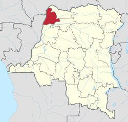
Sud-Ubangi (French for "South Ubangi") is one of the 21 new provinces of the Democratic Republic of the Congo created in the 2015 repartitioning. It lies in the northwest of the country on the Ubangi River.

Sud-Ubangi, Équateur, Mongala, Nord-Ubangi, and Tshuapa provinces are the result of the dismemberment of the former Équateur province. [2] Sud-Ubangi was formed from the Sud-Ubangi district and the independently administered city of Zongo. The town of Gemena was elevated to capital city of the new province.

The 2020 population was estimated to be 2,987,100. [3]

Administration

The capital of Sud-Ubangi is the town of Gemena. [4] The separately administered city of Zongo was to be capital of the new province.

The territories of the province are:

Related Research Articles

<span class="mw-page-title-main">Équateur (former province)</span> Place in Democratic Republic of the Congo

Équateur was a province in the northwest of the Belgian Congo and the successor Republic of the Congo, now known as Democratic Republic of the Congo. It had its origins in the Équateur District of the Congo Free State, the private property of King Leopold II of Belgium. It was upgraded to the status of a province in 1917. Between 1933 and 1947 it was named Coquilhatville. In 1962 it was divided into three smaller provinces, but there were recombined in 1966. Équateur was one of the eleven provinces of the Democratic Republic of the Congo until 2015, when it was split into the new, smaller Équateur province, as well as the Tshuapa, Mongala, Nord-Ubangi and Sud-Ubangi provinces.

<span class="mw-page-title-main">Zongo, Sud-Ubangi (DR Congo)</span> City in Sud-Ubangi, DR Congo

Zongo is a city in Sud-Ubangi Province in the northwestern part of the Democratic Republic of Congo, lying on the south bank of the Ubangi River, across from Bangui in the Central African Republic. It is linked by ferry to Bangui but has declined in importance as a transport hub since much traffic moved east in the late 1980s.

<span class="mw-page-title-main">Province of Équateur</span> Province of the Democratic Republic of the Congo

Équateur is one of the 21 new provinces of the Democratic Republic of the Congo created in the 2015 repartitioning. Équateur, Mongala, Nord-Ubangi, Sud-Ubangi, and Tshuapa provinces are the result of the dismemberment of the former Équateur province. The new province was formed from the Équateur district and the independently administered city of Mbandaka which retained its status as a provincial capital.

<span class="mw-page-title-main">Provinces of the Democratic Republic of the Congo</span> First-level administrative division of the Democratic Republic of the Congo

Article 2 of the Constitution of the Democratic Republic of the Congo divides the country into the capital city of Kinshasa and 25 named provinces. It also gives the capital the status of a province. Therefore, in many contexts Kinshasa is regarded as the 26th province.

Gemena is the capital city of Sud-Ubangi Province in the Democratic Republic of the Congo. It has a population of 350,511 (2017). The city has a large airport and hosts the 10th integrated Brigade of the new FARDC since 2007.

<span class="mw-page-title-main">Index of Democratic Republic of the Congo–related articles</span>

Articles related to the Democratic Republic of the Congo include:

<span class="mw-page-title-main">Équateur District</span> District in Équateur Province, Democratic Republic of the Congo

Équateur District was a former district of the Congo Free State, Belgian Congo and Democratic Republic of the Congo. In 1914 it became part of former Équateur Province. The district went through various changes of extent and name over the years. The original district roughly corresponds to the current provinces of Équateur and Tshuapa.

<span class="mw-page-title-main">Mongala</span> Province of the Democratic Republic of the Congo

Mongala is one of the 21 new provinces of the Democratic Republic of the Congo created in the 2015 repartitioning. Mongala, Équateur, Nord-Ubangi, Sud-Ubangi, and Tshuapa provinces are the result of the dismemberment of the former Équateur province. Mongala was formed from the Mongala District whose town of Lisala was elevated to capital city of the new province.

<span class="mw-page-title-main">Nord-Ubangi</span> Province of the Democratic Republic of the Congo

Nord-Ubangi is one of the 21 new provinces of the Democratic Republic of the Congo created in the 2015 repartitioning. Nord-Ubangi, Équateur, Mongala, Sud-Ubangi, and Tshuapa provinces are the result of the dismemberment of the former Équateur province.

<span class="mw-page-title-main">Tshuapa</span> Province of the Democratic Republic of the Congo

Tshuapa is one of the 21 new provinces of the Democratic Republic of the Congo created in the 2015 repartitioning. Tshuapa, Équateur, Mongala, Nord-Ubangi, and Sud-Ubangi provinces are the result of the dismemberment of the former Équateur province. Tshuapa was formed from the Tshuapa District whose town of Boende was elevated to capital city of the new province.

Ubangi Province (1962−1966) was a former province in the north of Zaire, formed from a division of the first Équateur Province.

<span class="mw-page-title-main">Tshuapa District</span> District in Équateur, Democratic Republic of the Congo

Tshuapa District, was a district of the Belgian Congo and the Democratic Republic of the Congo created in 1933 in the Coquilhatville Province. At its greatest extent it roughly corresponded to the present provinces of Équateur and Tshuapa.

<span class="mw-page-title-main">Mongala District</span> District in Équateur, Democratic Republic of the Congo

Mongala District was a district of the Belgian Congo and the Democratic Republic of the Congo. It went through various changes in extent. It covered roughly the same area as the present Mongala province and most of Nord-Ubangi province.

<span class="mw-page-title-main">Districts of the Belgian Congo</span>

The Districts of the Belgian Congo were the primary administrative divisions when Belgium annexed the Congo Free State in 1908, each administered by a district commissioner. In 1914 they were distributed among four large provinces, with some boundary changes. In 1933 the provinces were restructured into six, again with boundary changes. The number of districts fluctuated between 12 and 26 through splits and consolidations, first rising, then falling, then rising again.

Ubangi District was a district of the Congo Free State, Belgian Congo and Democratic Republic of the Congo. It went through various significant changes in extent.

Bangala District was a district of the Congo Free State and the Belgian Congo. It went through various significant changes in extent. The eastern part very roughly corresponded to the present province of Mongala.

Lulonga District was a district of the Belgian Congo created in 1912 and dissolved in 1933. Today part of Lulonga is in the current province of Équateur, and part in the province of Tshuapa.

Congo-Ubangi District, was a district of the Belgian Congo created in 1933 in the Coquilhatville Province. It had been dissolved by 1954.

<span class="mw-page-title-main">Cuvette Centrale Province</span> Province in Democratic Republic of the Congo

Cuvette Centrale Province was a province of the Democratic Republic of the Congo that existed between 1963 and 1966 during the Congo Crisis.

References

  1. "Le Président Félix Tshisekedi investit par ordonnance les gouverneurs du Sankuru et Sud-Ubangi". ACP Média Public (in French). 7 August 2019. Retrieved 11 August 2019.
  2. "Découpage territorial : procédures d'installation de nouvelles provinces". Radio Okapi (in French). 13 July 2015. Archived from the original on 19 July 2015. Retrieved 5 June 2020.
  3. "Congo (Dem. Rep.): Provinces, Major Cities & Towns - Population Statistics, Maps, Charts, Weather and Web Information". www.citypopulation.de. Retrieved 2024-02-11.
  4. "Provinces of the Democratic Republic of Congo". Statiods.com.