Kongo Central | |
---|---|
![]() Zongo Falls on the Inkisi River | |
![]() | |
Coordinates: 05°49′S13°29′E / 5.817°S 13.483°E | |
Country | ![]() |
Capital and largest city | Matadi |
Government | |
• Body | Provincial Assembly of Kongo Central |
• Governor | Grâce Bilolo [1] |
Area | |
• Total | 53,920 km2 (20,820 sq mi) |
Population (2020) | |
• Total | 6,838,500 |
• Density | 130/km2 (330/sq mi) |
Time zone | UTC+1 (West Africa Time) |
ISO 3166 code | CD-BC |
License Plate Code | ![]() |
Official language | French |
National languages | Kikongo ya Leta, lingala [2] |
HDI (2017) | 0.432 [3] low |
Non-national language | Kikongo |
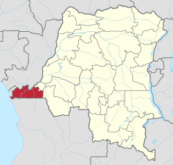
Kongo Central (Kongo : Kongo dia Kati [4] [5] ), formerly Bas-Congo, is one of the 26 provinces of the Democratic Republic of the Congo. [6] Its capital is Matadi.
At the time of independence, the area now encompassing Kongo Central was part of the greater province of Léopoldville, along with the capital city of Kinshasa and the districts of Kwango, Kwilu and Mai-Ndombe. Under Belgian colonial rule, the province was known as Bas-Congo (as in "Lower Congo River") and was renamed Kongo Central after independence. [7] [8]
Under the regime of Mobutu Sese Seko from 1965 to 1997, the Congo river was renamed as Zaire. The province was named as Bas-Zaïre. The name was later reverted to Bas-Congo. It was subsequently renamed as Kongo Central in 2015.
Kongo Central is the only province in the country with an ocean coastline; it has narrow frontage on the Atlantic Ocean to the west. It borders the city-province of Kinshasa to the north-east, the province of Kwango to the east, and the Republic of Angola to the south as well as the Republic of the Congo and Cabinda to the north.
The lower Congo River traverses the province from the north-east to the south-west. It is navigable from the Atlantic Ocean to the port city of Matadi after which there are a series of rapids that make it unnavigable until the Malebo Pool.
The provincial capital is Matadi, with Boma being the other official city. The remainder of the province is administratively divided into ten territories, the most of any province: [9]
Before 2015 these territories were divisions of the Bas-Fleuve, Cataractes and Lukaya districts; except for Moanda, which was attached to Boma (a city/district hybrid). [10]
Towns with their 2010 populations are:
Le lingala est fortement utilisé dans les milieux des enfants et des jeunes, tandis que le Kikongo est principalement utilisé chez les vieilles personnes.[Lingala is used extensively among children and youth, while Kikongo is used primarily among older people.]