Yellala Falls

Last updated

Yellala Falls
Yellala-Falls-1880.jpg
The Yellala Falls from the left bank, c. 1880
Democratic Republic of the Congo relief location map.jpg
Red pog.svg
Coordinates 5°43′32″S13°32′39″E / 5.725653°S 13.544083°E / -5.725653; 13.544083 Coordinates: 5°43′32″S13°32′39″E / 5.725653°S 13.544083°E / -5.725653; 13.544083
Watercourse Congo River

The Yellala Falls (Rapides de Yelala or Chutes Yelala; also spelled as Ielala) are a series of waterfalls and rapids on the Congo River just upstream from Matadi in the Democratic Republic of the Congo. The falls are the lowest of a long series of rapids that render the river unnavigable, forcing colonial explorers to travel by foot as far as the Stanley Pool 350 kilometres (220 mi) upstream. [1] The Congo is the second largest river in the world by volume of water discharged, and the deepest in the world. [2] The section of river that ends with the Yellala falls has over 300 species of fish, many found nowhere else. [3]

Contents

Location

The region drained by the Congo River covers one eighth of Africa, including both tropical rain forest and savanna, much of it in a huge, shallow basin. The present system of rivers seems to date from around five million years ago, not long ago on a geological time scale. At that time the Atlantic continental margin was lifted up and formed a barrier between the basin and the sea. A large lake formed before the Congo River broke through this barrier, running through a narrow, rocky channel about 350 kilometres (220 mi) long from Kinshasa to Matadi. The river is navigable both above and below this stretch, called the lower Congo. [4]

The upper portion of the Lower Congo starts with the steep Livingstone Falls just below Kinshasa and continues for 133 kilometres (83 mi) through a number of smaller rapids. The central portion of about 129 kilometres (80 mi) is navigable, at times lake-like and at times narrow and as deep as 200 metres (660 ft). The lower portion of about 88 kilometres (55 mi) is the steepest, with huge rapids at the Inga Falls and again at the Yellala falls, after which the river is navigable to the ocean. [4] About 1,250,000 cubic feet (35,000 m3) of water flows over the falls each second. [3]

First European discovery

The Stone of Yellala, bearing an inscription of 1485 by Diogo Cao Matadi, Congo, pedra de Ielala, Diogo Cao.jpg
The Stone of Yellala, bearing an inscription of 1485 by Diogo Cão

The Yellala Falls were reached by Europeans as early as 1485, when the Portuguese explorer Diogo Cão took a group of men as far as the falls before they were forced to turn back by disease, probably malaria. [5] In that place he set a padrão, a large stone cross-shaped marker, customary during the Portuguese Age of Discovery. The stone, which was not rediscovered until 1911, bears the words: "Aqui chegaram os navios do esclarecido rei D.João II de Portugal - Diogo Cão, Pero Anes, Pero da Costa." ("Here arrived the ships of illustrious John II, King of Portugal – Diogo Cão, Pero Anes, Pero da Costa".) [6]

Later European visitors and descriptions

Captain James Hingston Tuckey visited in 1816. He said that the local people thought the falls were the residence of an evil spirit, and that anyone who saw them would never see them again. [7] Visiting in the dry season, he was disappointed by the falls. He described the site as comprising a large hill of syenite, a course-grained igneous rock, on the south side. The northern side, made of the same material, was not as high, but steeper than the south. He described the river as having forced its course and within the middle of the river an island of slate "still defies its power, and breaks the current into two narrow channels; that near the south side gives vent to a great mass of water, over which the torrent rushes with great fury and noise, as may easily be conceived". [8]

Tuckey, who was sponsored by the Royal Geographical Society of London to obtain information on the slave trade, noted the brutality of the Portuguese slave trade and gathered valuable information about the geography, animals, plants, minerals and people of the region. [9] Talking of the people who lived above the falls, Tuckey said that fowls, eggs, manioc and fruits were the property of women. The items were never dealt with by the men without a discussion with their wives. Beads were given as presents from the men. [10] [fn 1]

In 1848 the Hungarian László Magyar ascended the Congo to the Yellala falls, before spending five years exploring the region to the south. Due to his lack of contact with the outside world, the valuable information that he gathered received little circulation. [9]

Yellala Falls from Sir Harry Johnston's 1884 account Yellala Falls 1883.png
Yellala Falls from Sir Harry Johnston's 1884 account

Sir Richard Francis Burton, who first saw the falls in 1863, wrote a description of the great Yellala. Waves developed in the course of the river "for a mile and a half above". Afterwards, the water heads down a slope of around thirty feet "in 300 yards, spuming, colliding and throwing up foam, which looks dingy white against the dull yellow-brown of the less disturbed channel - the movement is that of waves dashing upon a pier". [13] He went on: "The old river-valley, shown by the scarp of the rocks, must have presented gigantic features, and the height of the trough-walls, at least a thousand feet, gives the Yellala a certain beauty and grandeur. The site is apparently the highest axis of the dividing ridge separating the maritime lowlands from the inner plateau". [14]

The explorer Henry Morton Stanley, who visited the falls on April 6, 1880, wrote that over a five or six mile stretch the incline was only 45 feet (14 m), but that the "general fury of the water is caused by the obstructions which the giant volume meets in the bed of the narrow defile." [15] Sir Harry Johnston, who visited the falls in 1883, called the river "the last grand fall of Yellala" and detailed the sight and sounds of his impression of the falls. [16]

Ecological importance

Steatocranus gibbiceps, a species of cichlid found in the lower Congo Steatocranus gibbiceps.jpg
Steatocranus gibbiceps , a species of cichlid found in the lower Congo

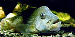
The Yellala Falls and the other falls and rapids upstream have largely isolated the aquatic fauna of the Congo Basin for around five million years, a significant period on an evolutionary timescale. [3] The cichlid genera Steatocranus , Nanochromis , Lamprologus and Teleogramma are found only in the Congo basin. Several dozen species in these genera are found only in the lower Congo. Steatocranus are rheophilic, meaning they have adapted to living in fast water. The four species of Teleogramma are found only in the lower Congo rapids. [4] Genetically distinct populations have been found on opposite sides of the river. Although only 1 mile (1.6 km) apart, powerful currents that may exceed 30 miles per hour (48 km/h) have prevented interbreeding. [3]

Notes

  1. A chart of the Congo based on Tuckey's account showed the river opening out to a width of 4 miles (6.4 km) above the falls. Stanley pointed out in forceful terms that this was wrong, saying of a map of Africa "I dare not image that Captain Tuckey is responsible for these errors ... We also have just above the Falls of Yellala a stretch of river four or five miles wide, with islands, the whole of which I shall be able to show you is sheer nonsense". [11] The map maker was at fault. Tuckey reached the Yellala Falls on 14 August, then went 40 miles (64 km) further to Inga, reaching the upper river on 24 August at a point where it was 300 yards (270 m) wide. It was not until 6 September that Tuckey's group was at a section about 280 miles (450 km) inland where the river was 4 miles (6.4 km) to 5 miles (8.0 km) wide. Due to sickness, fatal for Tuckey and others, the expedition was forced to return from this point. [12]

Related Research Articles

Diogo Cão Portuguese explorer

Diogo Cão, anglicised as Diogo Cam and also known as Diego Cam, was a Portuguese explorer and one of the most notable navigators of the Age of Discovery. He made two voyages sailing along the west coast of Africa in the 1480s, exploring the Congo River and the coasts of the present-day Angola and Namibia.

Madeira River Tributary of the Amazon River

The Madeira River is a major waterway in South America. It is estimated to be 1,450 km (900 mi) in length, while the Madeira-Mamoré is estimated near 3,250 km (2,020 mi) or 3,380 km (2,100 mi) in length depending on the measuring party and their methods. The Madeira is the biggest tributary of the Amazon, accounting for about 15% of the water in the basin. A map from Emanuel Bowen in 1747, held by the David Rumsey Map Collection, refers to the Madeira by the pre-colonial, indigenous name Cuyari:

The River of Cuyari, called by the Portuguese Madeira or the Wood River, is formed by two great rivers, which join near its mouth. It was by this River, that the Nation of Topinambes passed into the River Amazon.

Congo River River in central Africa

The Congo River, formerly also known as the Zaire River, is the second longest river in Africa, shorter only than the Nile, as well as the second largest river in the world by discharge volume, following only the Amazon. It is also the world's deepest recorded river, with measured depths around 219.5 m (720 ft). The Congo-Lualaba-Chambeshi River system has an overall length of 4,700 km (2,920 mi), which makes it the world's ninth-longest river. The Chambeshi is a tributary of the Lualaba River, and Lualaba is the name of the Congo River upstream of Boyoma Falls, extending for 1,800 km (1,120 mi).

Matadi Provincial capital and city in Kongo Central, Democratic Republic of the Congo

Matadi is the chief sea port of the Democratic Republic of the Congo and the capital of the Kongo Central province, adjacent to the border with Angola. It had a population of 245,862 (2004). Matadi is situated on the left bank of the Congo River, 148 km (92 mi) from the mouth and 8 km (5.0 mi) below the last navigable point before the rapids that make the river impassable for a long stretch upriver. It was founded by Sir Henry Morton Stanley in 1879.

Zambezi Major river in southern Africa

The Zambezi River is the fourth-longest river in Africa, the longest east-flowing river in Africa and the largest flowing into the Indian Ocean from Africa. Its drainage basin covers 1,390,000 square kilometres (540,000 sq mi), slightly less than half of the Nile's. The 2,574-kilometre-long river (1,599 mi) rises in Zambia and flows through eastern Angola, along the north-eastern border of Namibia and the northern border of Botswana, then along the border between Zambia and Zimbabwe to Mozambique, where it crosses the country to empty into the Indian Ocean.

Lualaba River River in Democratic Republic of the Congo

The Lualaba River flows entirely within the eastern Democratic Republic of the Congo. It provides the greatest streamflow to the Congo River, while the source of the Congo is recognized as the Chambeshi. The Lualaba is 1,800 kilometres (1,100 mi) long. Its headwaters are in the country's far southeastern corner near Musofi and Lubumbashi in Katanga Province, next to Zambia.

Pool Malebo Widening of the Congo River; part of the border between the R Congo and the DR Congo

The Pool Malebo, formerly Stanley Pool, also known as Mpumbu, Lake Nkunda or Lake Nkuna by local indigenous people in pre-colonial times, is a lake-like widening in the lower reaches of the Congo River. The river serves as the border between the Republic of the Congo on the north and the Democratic Republic of the Congo to the south.

Livingstone Falls Series of cataracts on the Congo River in the Democratic Republic of the Congo

Livingstone Falls, named for British explorer David Livingstone, are a succession of enormous rapids on the lower course of the Congo River in west equatorial Africa, downstream from Malebo Pool in the Democratic Republic of the Congo.

Colonization of the Congo Basin refers to the European colonization of the Congo Basin of tropical Africa. It was the last part of the continent to be colonized. By the end of the 19th century, the Basin had been carved up by European colonial powers, into the Congo Free State, the French Congo and the Portuguese Congo.

HMS <i>Congo</i> (1816)

HMS Congo was the first steam-powered warship built for the Royal Navy. She was classified as a steam sloop and was built in 1816 at Deptford Dockyard specifically for an exploration of the Congo River. Trials with her engine proved disappointing, and it was removed before she embarked on her first voyage.

James Hingston Tuckey was an Irish-born British explorer and a captain in the Royal Navy. Some sources mistakenly refer to him as James Kingston Tuckey.

Matadi–Kinshasa Railway

The Matadi–Kinshasa Railway is a railway line in Kongo Central province between Kinshasa, the capital of Democratic Republic of the Congo, and the port of Matadi.

The Ruki is a river in the Democratic Republic of the Congo. It is a left tributary of the Congo River. It may be seen as the lower reach of the Busira River, which in turn may be seen as the lower reach of the Tshuapa River.

Alexandre Delcommune

Alexandre Delcommune was a Belgian officer of the armed Force Publique of the Congo Free State who undertook extensive explorations of the country during the early colonial period of the Congo Free State. He explored many of the navigable waterways of the Congo Basin, and led a major expedition to Katanga between 1890 and 1893.

The Livingstone Inland Mission (LIM) was an evangelical missionary society that operated in what is now the Democratic Republic of the Congo between 1878 and 1884.

Alphonse van Gèle

Alphonse van Gèle, also written van Gele or Vangele, was a Belgian soldier who served as the Vice-Governor General of the Congo Free State from December 1897 until January 1899. He established the Equator Station, or Station de l’Équateur, today Mbandaka, and concluded a treaty with the powerful Zanzibar trader Tippu Tip at the Stanley Falls station, today Kisangani. He is known for having confirmed that the Uele River was the upper part of the Ubangi River.

Districts of the Congo Free State

The Districts of the Congo Free State were the primary administrative divisions of the Congo Free State from 1885 to 1908. There were various boundary changes in the period before the Congo Free State was annexed by Belgium to become the Belgian Congo.

The Bundi River is a river of the Democratic Republic of the Congo. It is a right tributary of the lower Congo River that enters the river below the Inga Falls. If the proposed Grand Inga Dam project goes ahead, the river valley will be flooded to form a huge lake.

Isangila Place in Kongo Central, Democratic Republic of the Congo

Isangila, formerly called Isanghila or Isanguila is the headquarters of a sector of the Seke-Banza territory in Kongo Central province of the Democratic Republic of the Congo.

Manyanga Place in Kongo Central, Democratic Republic of the Congo

Manyanga was a staging post on the route from the coast to Léopoldville during the days of the Congo Free State. It was at the upper end of a navigable reach of the Congo River from Isangila, further downstream to the west. Above Manyanga goods had to be carried by land round the falls and rapids to Stanley Pool.

References

  1. Conley 2000, p. 57.
  2. Oberg, Kevin (July 2008). "Discharge and other hydraulic measurements for characterizing the hydraulics of Lower Congo River" (PDF). U.S. Geological Survey.
  3. 1 2 3 4 Dickman 2009.
  4. 1 2 3 Schwarzer et al. 2011.
  5. Headrick 2010, p. 142.
  6. Kochnitzky 1948, p. 5.
  7. Tuckey & Smith 1818, p. 176.
  8. Tuckey & Smith 1818, p. 190.
  9. 1 2 Kalumvueziko 2009, p. 39.
  10. Spencer 1877, p. 142.
  11. Stanley's New Discoveries.
  12. Markham 1875, p. 227.
  13. Burton 1876, p. 284.
  14. Burton 1876, p. 287.
  15. Stanley 1885, pp. 202–3.
  16. Ballard 1887, p. 77.

Sources