
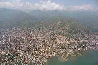
Kongo Central, formerly Bas-Congo, is one of the 26 provinces of the Democratic Republic of the Congo. Its capital is Matadi.

The Third Republic of the Democratic Republic of the Congo is a unitary state with a five-level hierarchy of types of administrative division. There are nine different types of country subdivision in a new hierarchy with no new types but with two from the previous one abolished.

Kouilou is a department of the Republic of the Congo. Covering the country's coastline, it has an area of 13,650 square kilometres and at the start of 2023 it was home to about 97,362 people. The department borders Niari Department, the commune of Pointe-Noire, and internationally, Gabon and the Cabinda area of Angola.

Goma is the capital and largest city of the North Kivu Province in the eastern region of the Democratic Republic of the Congo (DRC). It is located on the northern shore of Lake Kivu, next to the Rwandan city of Gisenyi. It shares its borders with Bukumu Chiefdom to the north, Rwanda to the east, Masisi Territory to the west, and is flanked by Lake Kivu to the south. The city lies in the Albertine Rift, the western branch of the East African Rift System, and is only 13–18 km (8.1–11.2 mi) south of the active Nyiragongo Volcano. With an approximate area of 75.72 square kilometers, the city has an estimated population of nearly 2 million people according to the 2022 census, while the 1984 estimate placed the number at 80,000.

Ituri Province is one of the 21 new provinces of the Democratic Republic of the Congo created in the 2015 repartitioning. Ituri, Bas-Uele, Haut-Uele, and Tshopo provinces are the result of the subdividing of the former Orientale province. Ituri was formed from the Ituri district whose town of Bunia was elevated to capital city of the new province.
Uvira is a city strategically located in the South Kivu Province of the eastern region of the Democratic Republic of the Congo (DRC). It is situated between Lake Tanganyika and the Mitumba Mountains, spanning approximately 16 square kilometers.
Gombe, also known as La Gombe, or Downtown Kinshasa, is one of the 24 communes of Kinshasa, in the western part of the Democratic Republic of the Congo (DRC). Encompassing a vast area of approximately 29.33 square kilometers, it is home to an approximate population of 49,024 residents (2014).

Bundu dia Kongo, known as BDK, is a new religious movement with a political and cultural agenda that is associated with the Kongo ethnic group. It was founded in June 1969 but officially in 1986 by Ne Muanda Nsemi, who was the group's current leader until his death and is mainly based in the Kongo Central (Bas-Congo) province in the Democratic Republic of the Congo.

Lulua District was a district of the Belgian Congo and the Democratic Republic of the Congo. The city of Kananga was at the center of the district, but had a separate administration. In 2015 Lulua District became the province of Kasaï-Central.

Bas-Fleuve District was a district located in the Kongo Central province, in the Democratic Republic of the Congo. It included the Tshela, Lukula and Seke-Banza territories.

Cataractes District was a district located in the Kongo Central province, in the Democratic Republic of the Congo. It dated back to the days of the Congo Free State and the Belgian Congo.
Seke-Banza is a community in Kongo Central province of the Democratic Republic of the Congo. It is the seat of the Seke-Banza territory. As of 2012 the town's population was estimated to be 6,286.
Seke-Banza Territory is an administrative area of the Kongo Central province of the Democratic Republic of the Congo, to the north of the city of Matadi. The administrative center is the town of Seke-Banza. The territory is divided into five sectors: Bundi, Isangila, Lufu, Mavu and Sumbi.
MadimbaTerritory is a territory in the Kongo Central Province of the Democratic Republic of the Congo (DRC). Its seat is the town of Madimba. The region covers an area of 8,260 square miles and is situated 100 km from Kinshasa. It spans from the Lukusu River in the north to Kintano in the west, and from the Inkisi River in the west to Kinkosi-Luidi in the southeast. The territory borders Kasangulu Territory to the northeast, Kimvula Territory to the southeast, Mbanza-Ngungu Territory to the west, and Angola to the south. Madimba Territory is home to an approximate population of 463,132 residents.

Bunyakiri is a town located in the high plateau of Kalehe Territory in the South Kivu Province in the eastern region of the Democratic Republic of the Congo (DRC). Bunyakiri is nearby the Bulehe and Mulamba villages. It is mainly inhabited by Tembo, Havu, Twa and Hunde ethnic groups.

Uvira Territory is a territory in South Kivu, Democratic Republic of the Congo. It is bordered by Walungu Territory to the north, Mwenga Territory to the west, Fizi Territory to the south, and Burundi and Lake Tanganyika to the east. Its capital is Uvira.
Justin Bitakwira Bihona-Hayi is a Congolese politician and a member of the National Assembly. He is the founder of the Alliance pour la République et la Conscience Nationale political party (ARCN) and a member of the Union for the Congolese Nation. He has been affiliated with several political parties, including the Union for Democracy and Social Progress (UDPS) and the People's Party for Reconstruction and Democracy (PPRD). He held various government positions, including Minister of Rural Development, Minister of Communication and Media and Minister of Relations with Parliament. As a minister, his political principles were described as nationalist, populist, opportunist, reformist, tribalist, and protectionist.
Banana District was a district of the Congo Free State and Belgian Congo. It disappeared in a reorganization of 1910.

Isangila, formerly called Isanghila or Isanguila is the headquarters of a sector of the Seke-Banza territory in Kongo Central province of the Democratic Republic of the Congo.
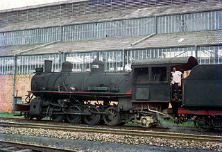
The Compagnie du chemin de fer du bas-Congo au Katanga (BCK) was a railway operator in the Congo Free State, Belgian Congo and later in the Democratic Republic of the Congo and Zaire. Most of the lines were in the southern Katanga Province, with links to the Kasai River for transport of mineral exports down to Kinshasa and onward to the port of Matadi, and a link to the Angolan railway network for transport to Lobito on the Atlantic.

