Madimba Territory

Last updated
Madimba Territory
Territoire de Madimba
Madimba Territory
Madimba Territory
CountryFlag of the Democratic Republic of the Congo.svg  DR Congo
Province Kongo Central
Capital Madimba
Government
  AdministratorAlphonsine Ngombe
Area
  Total8,260 km2 (3,190 sq mi)
Population
  Total463,132
  Density56/km2 (150/sq mi)
Time zone UTC+1 (WAT)
Official language French
National language Kikongo
Climate Cfa

MadimbaTerritory is a territory in the Kongo Central Province of the Democratic Republic of the Congo (DRC). Its seat is the town of Madimba. [1] [2] The region covers an area of 8,260 square miles and is situated 100 km from Kinshasa. It spans from the Lukusu River in the north to Kintano in the west, and from the Inkisi River in the west to Kinkosi-Luidi in the southeast. The territory borders Kasangulu Territory to the northeast, Kimvula Territory to the southeast, Mbanza-Ngungu Territory to the west, and Angola to the south. Madimba Territory is home to an approximate population of 463,132 residents. [3] [4] [5]

Contents

Madimba Territory is home to the Kisantu Botanical Garden (Jardin botanique de Kisantu), one of the largest botanical gardens in Central Africa. [6] [7] The Hôpital Saint-Luc, situated on the Nkandu plateau in Inkisi, is the region's first established medical facility. [8] [9] Madimba Territory houses several higher-educational institutions, including Kubama College (Collège Kubama), [10] [11] Institut Technique Industriel de Kisantu (ITI-Kisantu), [12] and Institut Luymas. [13] The territory is also home to Mbuela-Lodge, a holiday resort located near the town of Kisantu. [14]

Geography

Madimba Territory is located at a latitude of 4°9 and a longitude of 15°2, with an altitude of 210 meters above sea level. Madimba Territory experiences a humid subtropical climate with distinct seasons. The rainy season spans seven months, including September, October, November, December, January, April, and May. [6] Conversely, the dry season lasts five months, encompassing February, March (small season), June, July, and August. Temperature oscillations within the range of 20°C to 30°C are readily apparent, complemented by an annual precipitation ranging between 1200 mm and 1600 mm. [6]

Madimba's terrestrial composition predominantly comprises two primary types: sandy-clayey and clayey-sandy. The region's topography is characterized by low hills, valleys, and high plateaus. [6] Hydrographically, the Inkisi River dominates the territory. Incidentally, it is bordered by the Congo River to the north and is intersected by numerous watercourses and rivers, including Lukusu, Luidi, Mfidi, Ngufu, Geba, Wungu, Nsele, Tau, Luvu, and Lukunga. [6] The territory is well-connected with waterways, facilitating transportation and trade. Furthermore, the subsoil of Madimba is rich in valuable minerals like zinc ores, iron, copper, and mineral water, representing a source of potential economic wealth. [6]

History

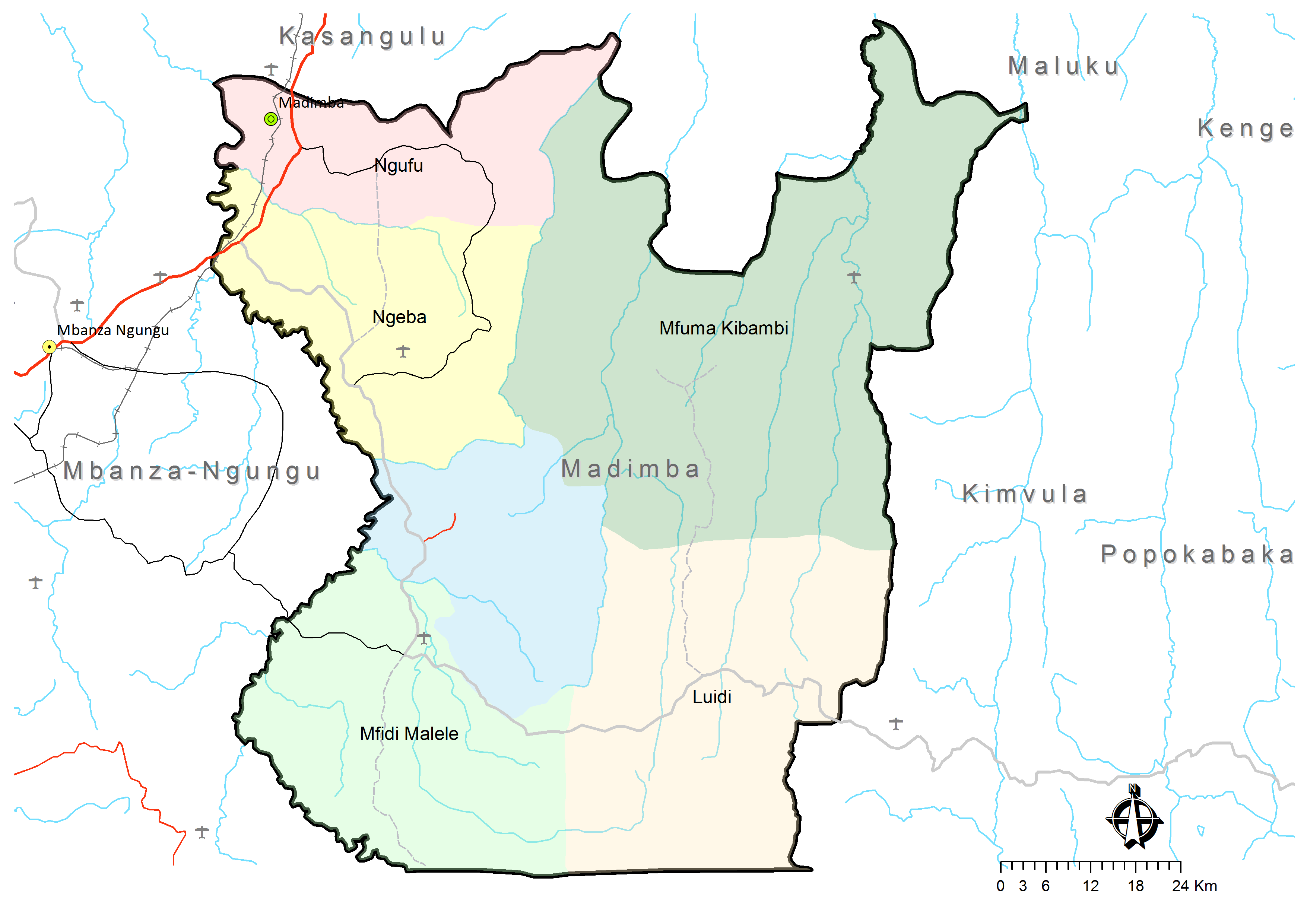
Madimba Territory is one of the earliest administrative territories established in the Democratic Republic of the Congo. It was created through the Ordinance of February 1, 1913, under the auspices of the colonial governor-general. Initially, the territory was demarcated into six discrete sectors, denominated as Luidi, Ngeba, Mfidi-Malele, Ngufu, Mfuma, and Gungu. [15]

2007 torrential rainfall

In April 2007, torrential downpours led to the destruction of approximately thirty houses and affected two primary schools in the Ngufu sector, causing a humanitarian crisis in the surrounding villages, including Kipaku, Kituengi, Kisundi, and Kilemfu. [16] Sébastien Ndomba, supervisor of the ONGD (National Council of Non-Governmental Development Organisations), a German organization, reports the incident rendered 196 people homeless, comprising 65 adults and 131 children. [16]

2011 traffic accident

On March 25, 2011, two people died, and 14 others were injured following a traffic accident in Kisantu. [17] The accident occurred on the Kisantu–Simula road when a large truck from Madimba Territory overturned not far from Kisantu, more than 200 kilometers east of Matadi. [17]

2022 fuel tank explosion

On September 14, 2022, eight people lost their lives, and twenty others sustained burns in an explosion involving a tanker truck in Mbuba, Madimba Territory. [18] The incident occurred around 5 p.m. when the tanker overturned due to a collision with a heavy-duty vehicle. Subsequently, the gasoline tank began to leak, prompting the local population to rush and attempt to collect the fuel. [18] The tanker exploded, resulting in the immediate loss of eight lives, including a soldier from the Republican Guard tasked with safeguarding the SEP-Congo pipeline. [18] The death toll later increased to ten by September 17. [19]

Administrative divisions

Madimba Territory is administratively divided into six sectors: [20] [1]

Economy

The region's economy is predominantly driven by agriculture, which serves as the central economic activity and vital source of livelihoods, sustenance, and economic stability. [6] The region's main agricultural commodities include maize, cassava, peanuts, yams, plantains, and market garden products, while cocoa, coffee, and oil palm are the primary cash crops. The area also engages in livestock raising, which includes cattle, poultry, and goats. [6] [21] [22] [23]

Related Research Articles

<span class="mw-page-title-main">Kongo Central</span> Province of the Democratic Republic of the Congo

Kongo Central, formerly Bas-Congo, is one of the 26 provinces of the Democratic Republic of the Congo. Its capital is Matadi.

Feshi is a territory located to the southern west in the Democratic Republic of the Congo. It is located in Kwango province.

Opala is a territory in the Tshopo Province of the Democratic Republic of the Congo.

<span class="mw-page-title-main">Chiefdoms and sectors of the Democratic Republic of the Congo</span>

In the Democratic Republic of the Congo, chiefdoms and sectors are rural administrative divisions of territories. They are further subdivided into groupings which themselves are divided into villages. Chiefdoms are led by traditional leaders officially recognized by the government whereas sector chiefs are appointed directly by the government.

Bondo Territory is a territory in the Bas-Uele Province of the Democratic Republic of the Congo. The administrative capital is the town of Bondo.

Luozi Territory is an administrative area in Kongo Central province of the Democratic Republic of the Congo. The headquarters are in the city of Luozi. The Luozi territory is also known as the Manianga.

Makanza or Mankanza Territory is an administrative area in Équateur Province in the Democratic Republic of the Congo. It lies along the main channel of the Congo River. Headquarters for the territory is the town of Makanza. The territory was created by presidential order on 6 October 1976.

Inongo Territory is a second-level administrative area (territory) in Maï-Ndombe Province in the Democratic Republic of the Congo. Its headquarters is in the provincial capital of Inongo.

Nyunzu is a territory in the Tanganyika Province of the Democratic Republic of the Congo.

Mutshatsha is a territory in the Lualaba Province of the Democratic Republic of the Congo.

Mitwaba is a territory in the Haut-Katanga Province of the Democratic Republic of the Congo.

Kanyama or Kaniama is a territory in the Haut-Lomami province of the Democratic Republic of the Congo.

<span class="mw-page-title-main">Dibaya Territory</span> Territory in Kasaï-Central, DR Congo

Dibaya is a territory in Kasai-Central province of the Democratic Republic of the Congo.

<span class="mw-page-title-main">Dimbelenge Territory</span> Territory in Kasaï-Central, DR Congo

Dimbelenge is a territory in Kasai-Central province of the Democratic Republic of the Congo.

Luiza is a territory of Kasai-Central province of the Democratic Republic of the Congo. It covers an area of 14,702 square kilometers. As of March 2021, its inhabitants numbered 1,515,339. It is represented in the National Assembly by four elected deputies.

Kabinda is a territory of Lomami province in the Democratic Republic of the Congo.

Kiri Territory is an administrative region of Mai-Ndombe Province, Democratic Republic of the Congo. The headquarters is the town of Kiri.

Ingende Territory is a second-level administrative area (territory) in Équateur Province in the Democratic Republic of the Congo. Its headquarters is the town of Ingende.

Bolia is a small town in Inongo Territory of Mai-Ndombe Province of the Democratic Republic of the Congo, located east of Lake Tumba. It is the headquarters for the Bolia Sector, which includes Bokwala, Lokanga, and Nkile. Its elevation is about 300 meters.

<span class="mw-page-title-main">Mahagi (territory)</span> Territory in Ituri, DR Congo

Mahagi is a territory and a locality of Ituri province in the Democratic Republic of the Congo. It is located in the northeastern part of the country, 1,900 km east of the capital Kinshasa.

References

  1. 1 2 "Territoire de Madimba: Fiche du territoire". Cellule d'Analyses des Indicateurs de Développement (CAID). Archived from the original on 30 May 2018.
  2. "Bas-Congo: le territoire de Madimba va souffler sur ses cent bougies" [Bas-Congo: the territory of Madimba will blow out its hundred candles]. www.mediacongo.net (in French). September 17, 2014. Retrieved 2023-09-30.
  3. Aundagba, Jean-Marie Pangodi; Djoza, Ruphin Djolu; Ashande, Colette Masengo; Lhemba, La Blonde Mbala; Kapalata, Fabrice Kogana; Baholy, Robijaona Rahelivovololoniaina; Ngbolua, Koto-te-Nyiwa (March 2020). "Enquête sur les conditions d'hygiène dans les écoles de la sous-division de Madimba (Province de Kongo-Central) en République Démocratique du Congo" (PDF). Allresearchjournal.com (in French). p. 296. Retrieved 2023-09-30.
  4. "Territoire de Madimba: Fiche du territoire: Données géographiques et culturelles". Cellule d'Analyses des Indicateurs de Développement (CAID). Archived from the original on 30 May 2018.
  5. Silu, Cynthia Pululu (2017). "Problématique de l'entrepreneuriat informel dans la cite de Kisantu. Typologie basée sur le modèle des 3e" [Problem of informal entrepreneurship in the city of Kisantu. Typology based on the 3e model.] (in French). Kongo Central Province, Democratic Republic of the Congo: Kongo University. Retrieved 2023-09-30.
  6. 1 2 3 4 5 6 7 8 "Le Territoire de Madimba" [The Madimba Territory]. Walhain.be (in French). Retrieved 2023-10-01.
  7. "Kongo-Central : une tête d'érosion menace la route reliant la RDC à l'Angola". Radio Okapi (in French). 2023-06-05. Retrieved 2023-10-01.
  8. "Hôpital Général de Référence St Luc, Kisantu". Ph-rdc.org (in French). 2020-02-09. Retrieved 2023-10-01.
  9. "Kongo-Central : la morgue de l'hôpital Saint Luc de Kisantu est saturée". Radio Okapi (in French). 2022-01-05. Retrieved 2023-10-01.
  10. "Kisantu : un enseignant meurt craie à la main dans une salle de classe". Radio Okapi (in French). 2021-11-24. Retrieved 2023-10-01.
  11. "Accueill". www.collegekubama.org. Retrieved 2023-10-01.
  12. "Institut Technique industriel de kisantu (I.T.I-KISANTU)". Schoolandcollegelistings.com (in French). Retrieved 2023-09-30.
  13. Mayala, Kimpozo (June 1, 2004). "Congo-Kinshasa: Diomi: une natte et une lampe pour un long voyage" [Congo-Kinshasa: Diomi: a mat and a lamp for a long journey]. AllAfrica (in French). Retrieved 2023-09-30.
  14. "Kisantu : ouverture ce jeudi de « Kimvuama », le forum économique sur le développement du Kongo-Central". Radio Okapi (in French). 2022-11-17. Retrieved 2023-10-01.
  15. Bulletin Officiel du Congo Belge, Volume 6 (in French). Princeton, New Jersey, United States: Princeton University. 1913. p. 552.
  16. 1 2 "Madimba : saison de pluie, 10 villages dans une situation humanitaire préoccupante". Radio Okapi (in French). 2007-10-04. Retrieved 2023-10-01.
  17. 1 2 "Accident de circulation à Kisantu: 2 morts et 14 blessés". Radio Okapi (in French). 2011-03-26. Retrieved 2023-10-01.
  18. 1 2 3 "Kongo-Central : des morts et des brulés graves à la suite de l'explosion d'un camion-citerne". Radio Okapi (in French). 2022-09-15. Retrieved 2023-10-01.
  19. "Kongo-Central : le bilan de l'explosion du camion-citerne passe de 7 à 10". Radio Okapi (in French). 2022-09-18. Retrieved 2023-10-01.
  20. Territoire de Madimba: Carte administrative (Map). Cellule d'Analyses des Indicateurs de Développement (CAID). Archived from the original on 30 May 2018.
  21. "Kongo-Central: lancement de la campagne de culture du manioc pour farine panifiable". Radio Okapi (in French). 2022-08-25. Retrieved 2023-10-01.
  22. Nsiese, Reagan; Nkedi, Frédéric (2023-04-20). "Kongo Central : présence des éleveurs des vaches à Kimayala, l'éclairage des autorités du territoire de Madimba - Kongo Média". kongomedia.net (in French). Retrieved 2023-10-01.
  23. Mwimbi, Delvard (April 21, 2023). "Madimba: loin d'appartenir aux Mbororos, des éleveurs des vaches à Kimayala viennent de Kinshasa (AT)" [Madimba: far from belonging to the Mbororos, cow breeders in Kimayala come from Kinshasa (AT)]. www.mediacongo.net (in French). Kinshasa, Democratic Republic of the Congo. Retrieved 2023-10-01.

4°9′S15°2′E / 4.150°S 15.033°E / -4.150; 15.033