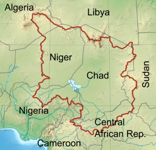
Central Africa

Last updated

Central Africa
UN Macroregion Central Africa.svg
Central Africa (United Nations Statistics Division sub-region)
Countries
Time zones UTC+01:00
UTC+02:00
This video over Central Africa and the Middle East was taken by the crew of Expedition 29 onboard the International Space Station in October 2011

Central Africa is a subregion of the African continent comprising various countries according to different definitions. Middle Africa is an analogous term used by the United Nations in its geoscheme for Africa and consists of the following countries: Angola, Burundi, Cameroon, Central African Republic, Chad, Democratic Republic of the Congo, Republic of the Congo, Equatorial Guinea, Gabon, Rwanda, and São Tomé and Príncipe. [1] These eleven countries are members of the Economic Community of Central African States (ECCAS). [1] Six of those countries (Cameroon, Central African Republic, Chad, Equatorial Guinea, Gabon, and Republic of the Congo) are also members of the Economic and Monetary Community of Central Africa (CEMAC) and share a common currency, the Central African CFA franc. [2]

Contents

.mw-parser-output .legend{page-break-inside:avoid;break-inside:avoid-column}.mw-parser-output .legend-color{display:inline-block;min-width:1.25em;height:1.25em;line-height:1.25;margin:1px 0;text-align:center;border:1px solid black;background-color:transparent;color:black}.mw-parser-output .legend-text{}
ECCAS/CEMAC state, part of Middle Africa
ECCAS state, part of Middle Africa
ECCAS state only Central Africa.png
   ECCAS/CEMAC state, part of Middle Africa
  ECCAS state, part of Middle Africa
  ECCAS state only

The African Development Bank, on the other hand, defines Central Africa as seven countries: Cameroon, Central African Republic, Chad, Republic of the Congo, Democratic Republic of Congo, Equatorial Guinea, and Gabon. [3]

List of Central African countries

Central AfricaFlag of Angola.svg  Angola
Flag of Burundi.svg  Burundi
Flag of Cameroon.svg  Cameroon
Flag of the Central African Republic.svg  Central African Republic
Flag of Chad.svg  Chad
Flag of the Democratic Republic of the Congo.svg  DR Congo
Flag of Equatorial Guinea.svg  Equatorial Guinea
Flag of Gabon.svg  Gabon
Flag of the Republic of the Congo.svg  Republic of the Congo
Flag of Rwanda.svg  Rwanda
Flag of Sao Tome and Principe.svg  São Tomé and Príncipe

Background

Membership of ECCAS Mapa CEEAC.PNG
Membership of ECCAS

The Central African Federation (1953–1963), also called the Federation of Rhodesia and Nyasaland, was made up of what are now the nations of Malawi, Zambia, and Zimbabwe. Similarly, the Anglican Church of the Province of Central Africa covers dioceses in Botswana, Malawi, Zambia, and Zimbabwe, while the Church of Central Africa, Presbyterian has synods in Malawi, Zambia, and Zimbabwe. These states are now typically considered part of East or Southern Africa. [4]

Geography

Congo Basin Rainforest - Ituri (20874628148).jpg
Congo Basin

The Congo River basin has historically been ecologically significant to the populations of Central Africa, serving as an important supra-regional organization in Central Africa.

History

Prehistory

Archeological finds in Central Africa have been made which date back over 100,000 years. [5] According to Zagato and Holl, there is evidence of iron smelting in the Central African Republic that may date back to 3000 to 2500 BCE. [6] Extensive walled settlements have recently been found in Northeast Nigeria, approximately 60 km (37 mi) southwest of Lake Chad dating to the first millennium BCE. [7]

Trade and improved agricultural techniques supported more sophisticated societies, leading to the early civilizations of West Africa: Sao, Kanem, Bornu, Shilluk, Baguirmi, and Wadai. [8]

Around 2500 BCE, Bantu migrants had reached the Great Lakes Region in Central Africa. Halfway through the first millennium BCE, the Bantu had also settled as far south as what is now Angola.

Ancient history

Sao civilization

The West African Sao civilization flourished from ca. the 6th century BCE to as late as the 16th century CE in northern Central Africa. The Sao lived by the Chari River south of Lake Chad in territory that later became part of Cameroon and Chad. They are the earliest people to have left clear traces of their presence in the territory of modern Cameroon. Today, several ethnic groups of northern Cameroon and southern Chad but particularly the Sara people claim descent from the civilization of the Sao. Sao artifacts show that they were skilled workers in bronze, copper, and iron. [9] Finds include bronze sculptures and terra cotta statues of human and animal figures, coins, funerary urns, household utensils, jewelry, highly decorated pottery, and spears. [10] The largest Sao archaeological finds have been made south of Lake Chad.

Kanem Empire

The Kanem and Bornu Empires in 1810 Borno in 1810.svg
The Kanem and Bornu Empires in 1810

The West-Central African kingdom of Kanem–Bornu Empire was centered in the Lake Chad Basin. It was known as the Kanem Empire from the 9th century CE onward and lasted as the independent kingdom of Bornu until 1900. At its height it encompassed an area covering not only much of Chad, but also parts of modern eastern Niger, northeastern Nigeria, northern Cameroon and parts of South Sudan. The history of the Empire is mainly known from the Royal Chronicle or Girgam discovered in 1851 by the German traveler Heinrich Barth. [11] Kanem rose in the 8th century in the region to the north and east of Lake Chad. The Kanem empire went into decline, shrank, and in the 14th century was defeated by Bilala invaders from the Lake Fitri region. [12]

Bornu Empire

The Kanuri people of West Africa led by the Sayfuwa migrated to the west and south of the lake, where they established the Bornu Empire. By the late 16th century the Bornu empire had expanded and recaptured the parts of Kanem that had been conquered by the Bulala. [13] Satellite states of Bornu included the Damagaram in the west and Baguirmi to the southeast of Lake Chad.

Shilluk Kingdom

The Shilluk Kingdom was centered in South Sudan from the 15th century from along a strip of land along the western bank of White Nile, from Lake No to about 12° north latitude. The capital and royal residence were in the town of Fashoda. The kingdom was founded during the mid-fifteenth century CE by its first ruler, Nyikang. During the nineteenth century, the Shilluk Kingdom faced decline following military assaults from the Ottoman Empire and later British and Sudanese colonization in Anglo-Egyptian Sudan.

Baguirmi Kingdom

The Kingdom of Baguirmi existed as an independent state during the 16th and 17th centuries southeast of West-Central Africa Lake Chad region in what is now the country of Chad. Baguirmi emerged to the southeast of the Kanem–Bornu Empire. The kingdom's first ruler was Mbang Birni Besse. Later in his reign, the Bornu Empire conquered and made the state a tributary.

Wadai Empire

Abeche, capital of Wadai, in 1918 after the French had taken over La ville d'Abeche, vue du poste Francais.jpg
Abéché, capital of Wadai, in 1918 after the French had taken over

The Wadai Empire was centered in Chad from the 17th century. The Tunjur people founded the Wadai Kingdom to the east of Bornu in the 16th century. In the 17th century, there was a revolt of the Maba people who established a Muslim dynasty. At first, Wadai paid tribute to Bornu and Durfur, but by the 18th century, Wadai was fully independent and had become an aggressor against its neighbors. [8]

Lunda Empire

Lunda town and dwelling Lunda houses-1854.jpg
Lunda town and dwelling

Following the Bantu Migration from Western Africa, Bantu kingdoms and empires began to develop in southern Central Africa. In the 1450s, a Luba from the royal family Ilunga Tshibinda married Lunda queen Rweej and united all Lunda peoples. Their son Mulopwe Luseeng expanded the kingdom. His son Naweej expanded the empire further and is known as the first Lunda emperor, with the title Mwata Yamvo (mwaant yaav, mwant yav), the "Lord of Vipers". The Luba political system was retained, and conquered peoples were integrated into the system. The mwata yamvo assigned a cilool or kilolo (royal adviser) and tax collector to each state conquered. [14]

Numerous states claimed descent from the Lunda. The Imbangala of inland Angola claimed descent from a founder, Kinguri, brother of Queen Rweej, who could not tolerate the rule of mulopwe Tshibunda. Kinguri became the title of kings of states founded by Queen Rweej's brother. The Luena (Lwena) and Lozi (Luyani) in Zambia also claim descent from Kinguri. During the 17th century, a Lunda chief and warrior called Mwata Kazembe set up an Eastern Lunda kingdom in the valley of the Luapula River. The Lunda's western expansion also saw claims of descent by the Yaka and the Pende. The Lunda linked Central Africa with the western coast trade. The kingdom of Lunda came to an end in the 19th century when it was invaded by the Chokwe, who were armed with guns. [15]

Kongo Kingdom

Kongo in 1711 KingdomKongo1711.png
Kongo in 1711

By the 15th century CE, the farming Bakongo people (ba being the plural prefix) were unified as the Kingdom of Kongo under a ruler called the manikongo , residing in the fertile Pool Malebo area on the lower Congo River. The capital was M'banza-Kongo. With superior organization, they were able to conquer their neighbors and extract tribute. They were experts in metalwork, pottery, and weaving raffia cloth. They stimulated interregional trade via a tribute system controlled by the manikongo. Later, maize (corn) and cassava (manioc) would be introduced to the region via trade with the Portuguese at their ports at Luanda and Benguela. The maize and cassava would result in population growth in the region and other parts of Africa, replacing millet as the main staple.

By the 16th century, the manikongo held authority from the Atlantic in the west to the Kwango River in the east. Each territory was assigned a mani-mpembe (provincial governor) by the manikongo. In 1506, Afonso I (1506–1542), a Christian, took over the throne. Slave trading increased with Afonso's wars of conquest. About 1568 to 1569, the Jaga invaded Kongo, laying waste to the kingdom and forcing the manikongo into exile. In 1574, Manikongo Álvaro I was reinstated with the help of Portuguese mercenaries. During the latter part of the 1660s, the Portuguese tried to gain control of Kongo. Manikongo António I (1661–1665), with a Kongolese army of 5,000, was destroyed by an army of Afro-Portuguese at the Battle of Mbwila. The empire dissolved into petty polities, fighting among each other for war captives to sell into slavery. [16]

Kongo gained captives from the Kingdom of Ndongo in wars of conquest. Ndongo was ruled by the ngola. Ndongo would also engage in slave trading with the Portuguese, with São Tomé being a transit point to Brazil. The kingdom was not as welcoming as Kongo; it viewed the Portuguese with great suspicion and as an enemy. The Portuguese in the latter part of the 16th century tried to gain control of Ndongo but were defeated by the Mbundu. Ndongo experienced depopulation from slave raiding. The leaders established another state at Matamba, affiliated with Queen Nzinga, who put up a strong resistance to the Portuguese until coming to terms with them. The Portuguese settled along the coast as trade dealers, not venturing on conquest of the interior. Slavery wreaked havoc in the interior, with states initiating wars of conquest for captives. The Imbangala formed the slave-raiding state of Kasanje, a major source of slaves during the 17th and 18th centuries. [17]

Modern history

French explorer Paul Du Chaillu confirmed the existence of Pygmy peoples of central Africa A journey to Ashango-Land, and further penetration into equatorial Africa (1874) (14594947249).jpg
French explorer Paul Du Chaillu confirmed the existence of Pygmy peoples of central Africa

During the Conference of Berlin in 1884–85 Africa was divided up between the European colonial powers, defining boundaries that are largely intact with today's post-colonial states. [18] On 5 August 1890 the British and French concluded an agreement to clarify the boundary between French West Africa and what would become Nigeria. A boundary was agreed along a line from Say on the Niger to Barruwa on Lake Chad, but leaving the Sokoto Caliphate in the British sphere. [19] Parfait-Louis Monteil was given charge of an expedition to discover where this line actually ran. [20] On 9 April 1892 he reached Kukawa on the shore of the lake. [21] Over the next twenty years a large part of the Chad Basin was incorporated by treaty or by force into French West Africa. On 2 June 1909, the Wadai capital of Abéché was occupied by the French. [22] The remainder of the basin was divided by the British in Nigeria, who took Kano in 1903, [23] and the Germans in Cameroon.

The countries of the basin regained their independence between 1956 and 1962, retaining the colonial administrative boundaries. Chad, Gabon, the Republic of the Congo, and the Central African Republic became autonomous states with the dissolution of French Equatorial Africa in 1958, gaining full independence in 1960. The Democratic Republic of the Congo also gained independence from Belgium in 1960, but quickly devolved into a period of political upheaval and conflict known as the Congo Crisis (19601965) which ended with the installment of Joseph Mobutu as president and renamed the country Zaire in 1971. Burundi claimed independence from Belgian Ruanda-Urundi in 1962, becoming a constitutional monarchy under Mwami Mwambutsa IV. Rwanda, also part of Ruanda-Urundi, gained independence in 1962 following the ethnic violence of the Rwandan Revolution, transitioning from a Tutsi monarchy to a Hutu-dominated republic. Equatorial Guinea gained independence from Spain in 1968, leading to the election of Francisco Macías Nguema, now widely regarded as one of the most brutal dictators in history. In 1961, Angola became involved in the Portuguese Colonial War, a 13-year-long struggle for independence in Lusophone Africa. It gained independence only in 1975, following the 1974 Carnation Revolution in Lisbon. São Tomé and Príncipe also gained independence in 1975 in the aftermath of the Carnation Revolution. In 2011, South Sudan gained its independence from the Republic of Sudan after over 50 years of war.

In the 21st century, many jihadist and Islamist groups began to operate in the Central African region, including the Seleka and the Ansaru.

Over the course of the 2010s, the internationally unrecognized secessionist state called Ambazonia gained increasing momentum in its home regions, resulting in the ongoing Anglophone Crisis in Cameroon. [24]

Economy

Fishing in Central Africa Fishing In Maridi.jpg
Fishing in Central Africa

The main economic activities of Central Africa are farming, herding and fishing. At least 40% of the rural population of northern and eastern Central Africa lives in poverty and routinely face chronic food shortages. [25] Crop production based on rain is possible only in the southern belt. Slash-and-burn agriculture is a common practice. [26] Flood recession agriculture is practiced around Lake Chad and in the riverine wetlands. [27] Nomadic herders migrate with their animals into the grasslands of the northern part of the basin for a few weeks during each short rainy season, where they intensively graze the highly nutritious grasses. When the dry season starts they move back south, either to grazing lands around the lakes and floodplains, or to the savannas further to the south. [28]

In the 2000–01 period, fisheries in the Lake Chad basin provided food and income to more than 10 million people, with a harvest of about 70,000 tons. [25] Fisheries have traditionally been managed by a system where each village has recognized rights over a defined part of the river, wetland or lake, and fishers from elsewhere must seek permission and pay a fee to use this area. The governments only enforced rules and regulations to a limited extent. [29] Local governments and traditional authorities are increasingly engaged in rent-seeking, collecting license fees with the help of the police or army. [30]

Oil is also a major export of the countries of northern and eastern Central Africa, notably making up a large proportion of the GDPs of Chad and South Sudan.

Demographics

UN Macroregion of Central Africa UN Macroregion Central Africa.svg
UN Macroregion of Central Africa
Kinshasa is a megacity with more than 15 million inhabitants Liesse populaire dans les rues de Kinshasa hier soir a la suite de la qualification de l'equipe nationale de la RD Congo.jpg
Kinshasa is a megacity with more than 15 million inhabitants
Pygmy hunter-gatherers in the Congo Basin Pygmees (RDC).jpg
Pygmy hunter-gatherers in the Congo Basin

Following the Bantu Migration, Central Africa is primarily inhabited by Native African or Bantu peoples and Bantu languages predominate. These include the Mongo, Kongo and Luba peoples. Central Africa also includes many Nilo-Saharan and Niger-Congo Ubangian communities: in north western Central Africa the Nilo-Saharan Kanuri [31] [32] predominate. Most of the Ubangian speakers in Africa (often grouped with Niger-Congo) are also found in Central Africa, such as the Gbaya, [33] Banda [33] and Zande, [34] [33] in northern Central Africa.

Notable Central African supra-regional organizations include the Lake Chad Basin Commission and the Economic Community of Central African States.

The predominant religions of Central Africa are Christianity and traditional faiths. Islam is also practiced in some areas in Chad and the Central African Republic.

NameCapitalCurrencyOfficial languagesArea (km2)Population (2021) [35] [36]
Angola [37] Luanda Kwanza Portuguese 1,246,70034,503,774
Burundi Gitega Burundian franc French, Kirundi27,83412,551,213
Cameroon [38] Yaoundé Central African CFA franc French, English475,44227,198,628
Central African Republic [33] Bangui Central African CFA franc Sango, French622,9845,457,154
Chad [32] N'Djamena Central African CFA franc French, Arabic1,284,00017,179,740
Democratic Republic of the Congo [39] Kinshasa Congolese franc French2,344,85895,894,118
Republic of the Congo [40] Brazzaville Central African CFA franc French342,0005,835,806
Equatorial Guinea [41] Malabo Central African CFA franc Spanish, Portuguese, French28,0511,634,466
Gabon [42] Libreville Central African CFA franc French267,6682,341,179
São Tomé and Príncipe [43] São Tomé São Tomé and Príncipe Dobra Portuguese 964223,107

Due to common historical processes and widespread demographic movements between the countries of Central Africa before the Bantu Migration into much of southern Central Africa, the cultures of the region evidence many similarities and interrelationships. Similar cultural practices stemming from common origins as largely Nilo-Saharan or Bantu peoples are also evident in Central Africa including in music, dance, art, body adornment, initiation, and marriage rituals.

Some major Native African ethnic groups in Central Africa are as follows:

NameFamilyLanguageRegionCountryPopulation (million)Notes
Sara Nilo-Saharan, Central Sudanic Sara Chad BasinChad, [32] Cameroon, [44] Central African Republic [45] 3.5
Gbaya Niger-Congo, Ubangian Gbaya language Chad BasinCentral African Republic [33] 1.5
Zande Niger–Congo, Ubangian Zande Chad BasinSouth Sudan, [34] Central African Republic, [33] Democratic Republic of Congo1–4
Kanuri Nilo-Saharan, Western Saharan Kanuri Chad BasinEastern Nigeria, [31] Niger, [46] Cameroon, [47] Chad [32] 10
Banda Niger-Congo, Ubangian Banda language Chad BasinCentral African Republic [33] 1.5
Luba Niger-Congo, Bantu Luba language Sub-EquatorialDemocratic Republic of Congo10–15
Mongo Niger-Congo, Bantu Mongo language Sub-EquatorialDemocratic Republic of Congo10–15
Kongo Niger-Congo, Bantu Kongo language Sub-EquatorialDemocratic Republic of Congo, Angola, Republic of Congo10

Culture

Art from Cameroon Tambour fom-Babanki-Cameroun.jpg
Art from Cameroon

Clothing

Cuisine

Music

Religion

Film industry

Architecture

Further information in the sections of Architecture of Africa:

Science and technology

Further information in the sections of History of science and technology in Africa:

See also

Related Research Articles

<span class="mw-page-title-main">Kanem–Bornu Empire</span> Empire around Lake Chad, Africa, c. 700–1380

The Kanem–Bornu Empire existed in areas which are now part of Nigeria, Niger, Cameroon, Libya and Chad. It was known to the Arabian geographers as the Kanem Empire from the 8th century AD onward and lasted as the independent kingdom of Bornu until 1900.

<span class="mw-page-title-main">Sub-Saharan Africa</span> Region south of the Sahara Desert

Sub-Saharan Africa, Subsahara, or Non-Mediterranean Africa is the area and regions of the continent of Africa that lie south of the Sahara. These include Central Africa, East Africa, Southern Africa, and West Africa. Geopolitically, in addition to the African countries and territories that are situated fully in that specified region, the term may also include polities that only have part of their territory located in that region, per the definition of the United Nations (UN). This is considered a non-standardized geographical region with the number of countries included varying from 46 to 48 depending on the organization describing the region. The African Union (AU) uses a different regional breakdown, recognizing all 55 member states on the continent—grouping them into five distinct and standard regions.

The history of Zambia experienced many stages from colonisation to independence from Britain on 24 October 1964. Northern Rhodesia became a British sphere of influence in the present-day region of Zambia in 1888, and was officially proclaimed a British protectorate in 1924. After many years of suggested mergers, Southern Rhodesia, Northern Rhodesia, and Nyasaland were merged into the British Federation of Rhodesia and Nyasaland.

<span class="mw-page-title-main">Lake Chad</span> Lake in Central Africa

Lake Chad is an endorheic freshwater lake located at the junction of four countries: Nigeria, Niger, Chad, and Cameroon in western and central Africa respectively, with a catchment area of 1×10^6 km2 (390,000 sq mi). It an important wetland ecosystem in West-Central Africa. The lakeside is rich in reeds and swamps, and the plain along the lake is fertile, making it an important irrigated agricultural area. The lake is rich in aquatic resources and is one of the important freshwater fish producing areas in Africa.

<span class="mw-page-title-main">Kanuri people</span> African ethnic group

The Kanuri people are an African ethnic group living largely in the lands of the former Kanem and Bornu Empires in Niger, Nigeria, Chad, and Cameroon. As well as a diaspora community residing in Sudan. Those generally termed Kanuri include several subgroups and dialect groups, some of whom identify as distinct from the Kanuri. Most trace their origins to ruling lineages of the medieval Kanem-Bornu Empire, and its client states or provinces. In contrast to the neighboring Toubou or Zaghawa pastoralists, Kanuri groups have traditionally been sedentary, engaging in farming, fishing the Chad Basin, trade, and salt processing.

The pre-colonial history of the modern-day Democratic Republic of the Congo encompasses the history of the Congo Basin region up to the establishment of European colonial rule in the era of New Imperialism and particularly the creation of the Congo Free State and its expansion into the interior after 1885. As the modern territorial boundaries of the Democratic Republic of the Congo did not exist in this period, it is inseparable from the wider pre-colonial histories of Central Africa, the Great Lakes and Rift Valley as well as the Atlantic World and Swahili coast.

<span class="mw-page-title-main">Far North Region (Cameroon)</span> Region of Cameroon

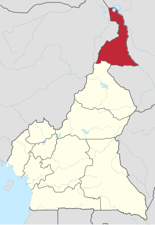
The Far North Region, also known as the Extreme North Region, is the northernmost and most populous constituent province of the Republic of Cameroon. It borders the North Region to the south, Chad to the east, and Nigeria to the west. The capital is Maroua.

The Kotoko kingdom was an monarchy in what is today northern Cameroon and Nigeria, and southwestern Chad. Its inhabitants and their modern descendants are known as the Kotoko people.

<span class="mw-page-title-main">Wadai Empire</span>

The Wadai Sultanate, sometimes referred to as the Maba Sultanate, was an African sultanate located to the east of Lake Chad in present-day Chad and the Central African Republic. It emerged in the seventeenth century under the leadership of the first sultan, Abd al-Karim, who overthrew the ruling Tunjur people of the area. It occupied land previously held by the Sultanate of Darfur to the northeast of the Sultanate of Baguirmi.

<span class="mw-page-title-main">Sao civilisation</span> Central African civilization

The Sao civilization flourished in Central Africa from ca. the 6th century BCE or 5th century BCE to as late as the 16th century AD. The Sao lived by the Chari River basin in territory that later became part of Cameroon and Chad. They are the earliest civilization to have left clear traces of their presence in the territory of modern Cameroon. Sometime around the 16th century, conversion to Islam changed the cultural identity of the former Sao. Today, several ethnic groups of northern Cameroon and southern Chad, but particularly the Sara and Kotoko, claim descent from the civilization of the Sao.

<span class="mw-page-title-main">Lunda people</span>

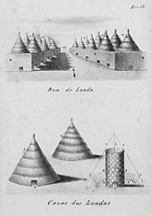
The Lunda are a Bantu ethnic group that originated in what is now the Democratic Republic of the Congo along the Kalanyi River and formed the Kingdom of Lunda in the 17th century under their ruler, Mwata Yamvo or Mwaant Yav, with their capital at Musumba. From there they spread widely through Katanga and into Eastern Angola, north-western Zambia and the Luapula valley of Zambia.

The colonial history of Angola is usually considered to run from the appearance of the Portuguese under Diogo Cão in 1482 (Congo) or 1484 until the independence of Angola in November 1975. Settlement did not begin until Novais's establishment of São Paulo de Loanda (Luanda) in 1575, however, and the Portuguese government only formally incorporated Angola as a colony in 1655 or on May 12, 1886.

<span class="mw-page-title-main">African empires</span> Umbrella term for some pre-colonial African kingdoms

African empires is an umbrella term used in African studies to refer to a number of pre-colonial African kingdoms in Africa with multinational structures incorporating various populations and polities into a single entity, usually through conquest.

<span class="mw-page-title-main">Bantu peoples</span> Ethnolinguistic group in Africa

The Bantu peoples are an ethnolinguistic grouping of approximately 400 distinct native African ethnic groups who speak Bantu languages. The languages are native to 24 countries spread over a vast area from Central Africa to Southeast Africa and into Southern Africa.

Makary is a town in Logone-et-Chari, Far North Region, Cameroon, West Africa. The town is located on the right (east) bank of a distributary of the Chari River in the delta just before it enters Lake Chad. The people are known as Kotoko, and the local language is Mpade, Fulani (Fulfulde) is the trade language. The primary economic activity was and is fishing.

Muhammad 'Abd al-Karim Sabun was (Sultan) of Wadai, a Muslim state in what is now eastern Chad, from 1804 to 1815. He pursued an expansionist policy, and was the greatest of the rulers of Wadai.

<span class="mw-page-title-main">Chad Basin</span> Largest endorheic basin in Africa

The Chad Basin is the largest endorheic basin in Africa, centered approximately on Lake Chad. It has no outlet to the sea and contains large areas of semi-arid desert and savanna. The drainage basin is approximately coterminous with the sedimentary basin of the same name, but extends further to the northeast and east.

<span class="mw-page-title-main">History of Central Africa</span>

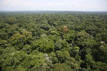
The history of Central Africa has been divided into its prehistory, its ancient history, the major polities flourishing, the colonial period, and the post-colonial period, in which the current nations were formed. Central Africa is the central region of Africa, bordered by North Africa, West Africa, East Africa, Southern Africa, the Atlantic Ocean, and the Sahara Desert. Colonial boundaries are reflected in the modern boundaries between contemporary Central African states, cutting across ethnic and cultural lines, often dividing single ethnic groups between two or more states.

The medieval and early modern history of Africa spans from the medieval and early modern period until the colonial period in the history of Africa.

References

  1. 1 2 "History and Map". UNOCA. 4 March 2016. Retrieved 28 December 2022.
  2. "Countries that use the Central African franc". Worlddata.info. Retrieved 28 December 2022.
  3. "Central Africa". African Development Bank - Building today, a better Africa tomorrow. 7 March 2019. Retrieved 28 December 2022.
  4. "The Central African Federation". Encyclopædia Britannica. 2007. Retrieved 16 December 2007.
  5. Philippe Lavachery et al., Komé-Kribi: Rescue Archaeology Along the Chad-Cameroon Oil Pipeline (2012), ISBN   3937248285
  6. Zangato, É.; Holl, A. F. C. (2010). "On the Iron Front: New Evidence from North-Central Africa". Journal of African Archaeology . 8 (1): 7–23. doi:10.3213/1612-1651-10153.
  7. J. Cameron Monroe, Akinwumi Ogundiran, Power and Landscape in Atlantic West Africa: Archeological Perspectives, p. 316, ISBN   1107009391, citing Magnavita 2004; Magnavita et al. 2004, 2006; Magnavita i (2013), p. 855: "The relatively recent discovery of extensive walled settlements at the transition from the Neolithic to the Early Iron Age in the Chad Basin (Magnavita et al., 2006) indicates what enormous sites and processes may still await recognition."
  8. 1 2 Appiah & Gates (2010), p. 254.
  9. Fanso (1989), p. 19.
  10. Fanso (1989), p. 19; Hudgens & Trillo (1999), p. 1051.
  11. Barth, Travels, II, 16–17.
  12. Falola (2008), p. 26.
  13. Falola (2008), p. 27.
  14. Shillington (2005), p. 141; Davidson (1991), p. 161.
  15. Davidson (1991), p. 161; Shillington (2005), pp. 139, 141.
  16. Collins & Burns (2007), pp. 185–188; Shillington (2005), pp. 196–198; Davidson (1991), pp. 156–157.
  17. Shillington (2005), pp. 198, 199; Davidson (1991), p. 158.
  18. Harlow (2003), p. 139.
  19. Hirshfield (1979), p. 26.
  20. Hirshfield (1979), p. 37-38.
  21. Lengyel (2007), p. 170.
  22. Mazenot (2005), p. 352.
  23. Falola (2008), p. 105.
  24. Roger, Jules, and Sombaye Eyango. "Inside the Virtual Ambazonia: Separatism, Hate Speech, Disinformation and Diaspora in the Cameroonian Anglophone Crisis." (2018).
  25. 1 2 Kenmore (2004), p. 220.
  26. "Agricultural Fires Seem to Engulf Central Africa". NASA. 20 June 2018. Retrieved 15 August 2020.
  27. Rangeley et al. (1994), p. 49.
  28. Kenmore (2004), p. 230.
  29. Kenmore (2004), p. 215.
  30. Kenmore (2004), p. 218.
  31. 1 2 "The World Factbook: Nigeria". World Factbook . Central Intelligence Agency . Retrieved 31 December 2013.
  32. 1 2 3 4 "The World Factbook: Chad". World Factbook . Central Intelligence Agency . Retrieved 31 December 2013.
  33. 1 2 3 4 5 6 7 "The World Factbook: Central African Republic". World Factbook . Central Intelligence Agency . Retrieved 31 December 2013.
  34. 1 2 "The World Factbook: South Sudan". World Factbook . Central Intelligence Agency . Retrieved 31 December 2013.
  35. "World Population Prospects 2022". United Nations Department of Economic and Social Affairs, Population Division. Retrieved 17 July 2022.
  36. "World Population Prospects 2022: Demographic indicators by region, subregion and country, annually for 1950-2100" (XSLX) ("Total Population, as of 1 July (thousands)"). United Nations Department of Economic and Social Affairs, Population Division. Retrieved 17 July 2022.
  37. "The World Factbook — Central Intelligence Agency". www.cia.gov. 13 July 2022.
  38. "The World Factbook — Central Intelligence Agency". www.cia.gov. 13 July 2022.
  39. "The World Factbook". www.cia.gov. Retrieved 8 May 2016.
  40. "The World Factbook". www.cia.gov. Retrieved 8 May 2016.
  41. "The World Factbook". www.cia.gov. Retrieved 8 May 2016.
  42. "The World Factbook". www.cia.gov. Retrieved 8 May 2016.
  43. "The World Factbook". www.cia.gov. Retrieved 8 May 2016.
  44. Goodwin, Stefan (2006). Africa's Legacies Of Urbanization. p. 191. ...and further west the even more numerous Sara [western Central African Republic, southern Chad, and northern Cameroon.
  45. MacDonald, Fiona (2000). Peoples of Africa: Burkina Faso-Comoros. Vol. 2. p. 86. ISBN   978-0-7614-7158-5. The Central African Republic is a land of many different peoples... The Sara (SAHR) live in the grain-growing lands of the north as well as across the border in Chad.
  46. "The World Factbook: Niger". World Factbook . Central Intelligence Agency . Retrieved 31 December 2013.
  47. "The World Factbook: Cameroon". World Factbook . Central Intelligence Agency . Retrieved 31 December 2013.

Bibliography