Fauna
| | This section is empty. You can help by adding to it. (March 2020) |
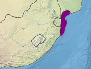
The Indian Ocean coastal belt is one of the nine recognised biomes of South Africa. They are described in terms of their vegetation and climatic variations. [1]
The Indian Ocean coastal belt is a region of coastal dunes and coastal grassy plains in KwaZuluNatal and the Eastern Cape, from sea level to an altitude of about 600 m Mean annual rainfall ranges from 819 to 1,272 mm, and falls throughout the year, peaking in summer. The mean annual temperature ranges from 19.1 °C near the Mbhashe River in the southwest to 22 °C in the north east near the Mozambican border, with hot summers and mild, frost-free winters. The belt is about 800 km long and narrow, with a maximum width of about 35 km in the north to less than 10 km in parts of the wild coast, and the total area is relatively small. [1]
The relief of the region varies between flat in Maputaland, rolling hills with deeply incised valleys between Richards Bay and Port Edward in KwaZulu-Natal and further south as far as the Great Kei River mouth. The Pondoland coast and other areas with sandstone geology have elevated plateaus with deep gorges. [2]
The dominant forest cover is interrupted by areas of grassland, with part of the belt comprising dense savanna vegetation, with scattered areas of forest and grassland. Most of the coastal belt outside the remaining patches of forest has been changed considerably. [3]
The following vegetation units have been identified:
| | This section is empty. You can help by adding to it. (March 2020) |
The region provides water supplies and fodder for livestock grazing. [1]
The biome is fairly well protected relative to the other South African biomes in that about 45% of the 20-year target is protected. [1]
Three scenarios have been modeled for climate change impacts on the South African biomes. The low risk scenario suggests a possible increase in area for this biome, with warm, moist conditions expanding southwest along the coast, and extending further inland, but the intermediate and high risk models show a possibility of less water availability and parts of the biome shifting to a savanna climate. [1]

South Africa occupies the southern tip of Africa, its coastline stretching more than 2,850 kilometres from the desert border with Namibia on the Atlantic (western) coast southwards around the tip of Africa and then northeast to the border with Mozambique on the Indian Ocean. The low-lying coastal zone is narrow for much of that distance, soon giving way to a mountainous escarpment that separates the coast from the high inland plateau. In some places, notably the province of KwaZulu-Natal in the east, a greater distance separates the coast from the escarpment. Although much of the country is classified as semi-arid, it has considerable variation in climate as well as topography. The total land area is 1,220,813 km2 (471,359 sq mi). It has the 23rd largest Exclusive Economic Zone of 1,535,538 km2 (592,875 sq mi).

Mtamvuna River is a river that forms the border between KwaZulu-Natal and the Eastern Cape Provinces in South Africa. The river has a wide mouth and flows into the Indian Ocean just south of Port Edward. The Mtamvuna river is approximately 162 km long with a catchment area of 1,553 km². The name means "the reaper of mouthfuls" because of the damage the river does to crops during floods.

The Maputaland-Pondoland bushland and thickets is one of the ecoregions of South Africa. It consists of the montane shrubland biome.

The Kwazulu-Cape coastal forest mosaic is a subtropical moist broadleaf forest ecoregion of South Africa. It covers an area of 17,800 square kilometers (6,900 sq mi) in South Africa's Eastern Cape and KwaZulu-Natal provinces.
The Maputaland coastal forest mosaic is a subtropical moist broadleaf forest ecoregion on the Indian Ocean coast of Southern Africa. It covers an area of 29,961 square kilometres (11,568 sq mi) in southern Mozambique, Eswatini, and the KwaZulu-Natal Province of South Africa. Mozambique's capital Maputo lies within the ecoregion.

The Coastal forests of eastern Africa, also known as the East African Coastal Forests or Zanzibar–Inhambane forests, is a tropical moist forest region along the east coast of Africa. The region was designated a biodiversity hotspot by Conservation International.

Pondoland or Mpondoland, is a natural region on the South African shores of the Indian Ocean. It is located in the coastal belt of the Eastern Cape province. Its territory is the former Mpondo Kingdom of the Mpondo people.

The wildlife of South Africa consists of the flora and fauna of this country in southern Africa. The country has a range of different habitat types and an ecologically rich and diverse wildlife, vascular plants being particularly abundant, many of them endemic to the country. There are few forested areas, much savanna grassland, semi-arid Karoo vegetation and the fynbos of the Cape Floristic Region. Famed for its national parks and big game, 297 species of mammal have been recorded in South Africa, as well as 849 species of bird and over 20,000 species of vascular plants.
The Umtamvuna Nature Reserve is situated in South Africa on the KwaZulu-Natal side of the Mtamvuna River, and is managed by Ezemvelo KZN Wildlife. The reserve is 3,257 hectares in extent and was established on 25 July 1971.
The Pondoland Centre of Plant Endemism is situated in the coastal region overlapping the provinces of KwaZulu-Natal and the Eastern Cape in South Africa. It is named after Pondoland and falls within the Maputaland-Pondoland-Albany Hotspot. The region consists of grassy plateaus incised by forested ravines and gorges. The main substrate in the area is Natal Group Sandstone, which was formed by sediments laid down about 500 million years ago in a rift underlying the eastern Agulhas Sea in the ancient continent of Gondwana. The region is about 18,800 hectares in extent, and lies along the coastline stretching about 15 kilometres inland with a maximum altitude of about 400 to 500 metres above sea level. The region is essentially a transition zone between sub-tropical and temperate climates.

The Maputaland-Pondoland-Albany Hotspot (MPA) is a biodiversity hotspot, a biogeographic region with significant levels of biodiversity, in Southern Africa. It is situated near the south-eastern coast of Africa, occupying an area between the Great Escarpment and the Indian Ocean. The area is named after Maputaland, Pondoland and Albany. It stretches from the Albany Centre of Plant Endemism in the Eastern Cape Province of South Africa, through the Pondoland Centre of Plant Endemism and KwaZulu-Natal Province, the eastern side of Eswatini and into southern Mozambique and Mpumalanga. The Maputaland Centre of Plant Endemism is contained in northern KwaZulu-Natal and southern Mozambique.

Maputaland is a natural region of Southern Africa. It is located in the northern part of the province of KwaZulu-Natal, South Africa between Eswatini and the coast. In a wider sense it may also include the southernmost region of Mozambique. The bird routes and coral reefs off the coast are major tourist attractions.

Southern African Sand Forest is a sand forest, or a subtropical forest plant community of the tropical and subtropical dry broadleaf forests biome. It grows on ancient sand dunes in northern KwaZulu-Natal and southern Mozambique. In South Africa these forests are known simply as Sand Forest, while in Mozambique they are known as Licuati Forest. The Southern African sand forest is part of the Maputaland coastal forest mosaic ecoregion.

Mediterranean forests, woodlands, and scrub is a biome defined by the World Wide Fund for Nature. The biome is generally characterized by dry summers and rainy winters, although in some areas rainfall may be uniform. Summers are typically hot in low-lying inland locations but can be cool near colder seas. Winters are typically mild to cool in low-lying locations but can be cold in inland and higher locations. All these ecoregions are highly distinctive, collectively harboring 10% of the Earth's plant species.

The Zambezian and mopane woodlands is a tropical and subtropical grasslands, savannas, and shrublands ecoregion of southeastern Africa.
The Albany Centre of Plant Endemism is situated in the coastal region of South Africa at the eastern end of the Eastern Cape Province. It is named after the district of Albany and falls within the Maputaland-Pondoland-Albany Hotspot. It is notable for its biodiversity and unique, endemic flora and fauna.
The Biodiversity of South Africa is the variety of living organisms within the boundaries of South Africa and its exclusive economic zone. South Africa is a region of high biodiversity in the terrestrial and marine realms. The country is ranked sixth out of the world's seventeen megadiverse countries, and is rated among the top 10 for plant species diversity and third for marine endemism.
Leisure Bay is a small seaside resort village located on the Lower South Coast of KwaZulu-Natal in South Africa.