The climate of the ecoregion is more temperate and seasonal than the surrounding lowlands. Temperatures can fall below 10°C (50°F) in the coldest months (July and August) and rise above 30°C (86°F) in the warm season. Temperatures are generally lower at higher elevations, and frosts can occur at the highest elevations.
Average annual rainfall varies between 1,200 and 2,000 mm, with two wet seasons – October to December and March to June – and two dry seasons – January and February and July to October. The climate is more humid than the surrounding lowlands, and with less distinct wet and dry seasons. Rainfall varies from mountain to mountain, with elevation, and with the direction of prevailing winds.[1]
Flora
The ecoregion consists of montane forests, grasslands, and savannas, transitioning to the East African montane moorlands on the highest peaks. The ecoregion is home to the Afromontane flora, which occurs in the mountains of eastern Africa, and is distinct from the lowland flora.[1][3]
Plant communities vary with elevation. Plant communities and characteristic species are generally similar from mountain to mountain. The elevational limits for plant communities can vary from mountain to mountain, depending on the mass and height of the mountain, its proximity to the ocean, and its distance from the equator – a phenomenon known as the Massenerhebung effect (mass-elevation effect).[3]
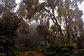
Juniperus procera forest. Single-dominant Juniperus procera (African juniper) forests are found on drier slopes at high elevations (1,800 to 2,900 meters), and occasionally as low as 1,000 meters. Average annual rainfall is usually between 1000 and 1150 mm, but can be more than 1250 mm. Juniperus procera does not regenerate in shade, so Juniperus procera forests often appear after forest fires.
Afromontane bamboo. Dense stands of the bamboo Oldeania alpina are found at high elevations (2400 to 3000 m, and up to 3,500 m on Mount Kenya). They are typically found on rich volcanic soils and gentle slopes where rainfall exceeds 1250 mm annually. The largest bamboo stands are on Mount Kenya (39,000 ha), Kenya's Aberdare Range (65000 ha) and Mau Escarpment (51000 ha) and Mount Meru.[5]
Afromontane moist transitional forest is found at lower elevations, and contains a mixture of Afromontane and non-Afromontane tree species.[3]
Fauna
There are eight endemic or restricted-range bird species in the ecoregion. The Aberdare cisticola (Cisticola aberdare), Abbott's starling (Cinnyricinclus femoralis), and Kenrick's starling (Poeoptera kenricki) occur on only two or three mountains or mountain ranges in the region. The Hunter's cisticola (Cisticola hunteri), Jackson's francolin (Francolinus jacksoni), and Sharpe's longclaw (Macronyx sharpei) range over most of the mountains in the ecoregion.[1]
There are nine endemic species of reptiles in the ecoregion, including six species of chameleons, most limited to a single mountain or range, and the montane viper (Vipera hindii).[1]
1 2 3 4 5 Kindt, R., van Breugel, P., Lillesø, J-P. B., Bingham, M., Demissew, S., Dudley, C., ... Graudal, L. O. V. (2011). Potential natural vegetation of Eastern Africa (Ethiopia, Kenya, Malawi, Rwanda, Tanzania, Uganda and Zambia): Volume 2: description and tree species composition for forest potential natural vegetation types. Forest & Landscape, University of Copenhagen. Forest & Landscape Working Papers, No. 62/2011
↑ Kindt R, van Breugel P, Lillesø J-PB, Gachathi F, Omondi W, Jamnadass R, and Graudal L. 2011: Potential natural vegetation of eastern Africa. Volume 8. Atlas and Tree Species Composition for Kenya. Forest & Landscape working paper xx-2013
↑ Lillesø, J-P.B., van Breugel, P., Kindt, R., Mbago, F., Moshi, H.N., Ndangalasi, H.J., Uronu, L.O.N., Jamnadass, R. and Graudal, L. 2014: Potential Natural Vegetation of Eastern Africa. Volume 10. Atlas and tree species composition for Tanzania. Department of Geosciences and Natural Resource Management, University of Copenhagen.
This page is based on this Wikipedia article Text is available under the CC BY-SA 4.0 license; additional terms may apply. Images, videos and audio are available under their respective licenses.