Sudanian savanna

Last updated
Sudan bioregion
بِلَادُ السُّوْدَان
Kob ewes Image02.jpg
Throughout the Sudan region's savanna grasslands, kob are found migrating along freshwater bodies
Ecoregion AT0722.svg
AT0705 map.png
Extension of the western and eastern ecoregions comprising the Sudan bioregion and divided by the Mandara mountains
Ecology
Realm Afrotropical
Biome Tropical savanna
Borders
Animals elephant, cheetah, giraffe, lion, buffalo, kob
Geography
Area2,550,451 km2 (984,735 sq mi)
Rivers White Nile, Niger and Chari
Climate type Tropical savanna (Aw)
Conservation
Conservation status Critical/endangered
Global 200 priority
Protected18.1% [1] [2]

The Sudanian savanna or Sudan region is a broad belt of tropical savanna that runs east and west across the African continent, from the Ethiopian Highlands in the east to the Atlantic Ocean in the west. It represents the central bioregion within the broader tropical savanna biome of the Afrotropical realm. The Sahel acacia savanna, a belt of drier grasslands, lies to the north, forming a transition zone between the Sudanian savanna and the Sahara Desert phytochorion. To the Sudan's south, the more humid forest-savanna mosaic forms a transition zone between the Sudanian savanna and the Guineo-Congolian forests that lie nearer the equator.

Contents

Etymology

The name Sudan derives from Arabic بلاد السودان (bilād as-sūdān) 'Land of the Blacks ', referring to Africa south of the Sahel. [3]

Physiographic province

The Sudanian savanna is one of the three distinct physiographic provinces of the larger African Massive division. Physiography divides this province into three distinct physiographic sections, the Niger Basin, the Lake Chad Basin, and the Middle Nile Basin. [4]

Ecoregions

The World Wide Fund for Nature divides the Sudanian savanna bioregion into two ecoregions, separated by the Mandara Plateau:

Geography

The area is predominantly a plateau with river valleys of the White Nile, Chad and Niger. It extends over 5,000 km (3,100 mi) in a band several hundred kilometers wide across Africa. It stretches from the Atlantic Ocean in Senegal, through southern Mali (known as French Sudan when it was a French colony), Burkina Faso, southern Niger, northern Ghana, northern Nigeria, southern Chad, Central African Republic, southern Sudan and South Sudan to the Ethiopian Highlands.

Climate

Average annual temperatures range from 23 to 29 °C (73 to 84 °F). Average temperatures in the coldest months are above 20 °C (68 °F) and above 30 °C (86 °F) in the hottest months. Daily temperatures fluctuate by up to 10–15 °C (50–59 °F). The summer monsoon brings rain from the equator. Annual precipitation ranges from 100–200 mm (3.9–7.9 in) in the north to 1,500–2,000 mm (59–79 in) in the south. During the dry winter season (Köppen Aw), the Harmattan northeasterly wind is bringing hot and dry air from the Sahara.

Flora

Sudanian savanna vegetation in Burkina Faso Pic de Nahouri MS4263.jpg
Sudanian savanna vegetation in Burkina Faso
Sudanian savanna with bunchgrass tufts of Andropogon gayanus, Pama Reserve, Burkina Faso. Ms 744 obs natiabouani 02.jpg
Sudanian savanna with bunchgrass tufts of Andropogon gayanus , Pama Reserve, Burkina Faso.

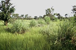
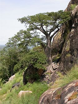
The Sudanian savanna is characterized by the coexistence of trees and grasses. Dominant tree species are often belonging to the Combretaceae and Caesalpinioideae; some Acacia species are also important. The dominant grass species are usually Andropogoneae, especially the genera Andropogon and Hyparrhenia , on shallow soils also Loudetia and Aristida . Much of the Sudanian savanna region is used in the form of parklands, where useful trees, such as shea, baobab, locust-bean tree and others are spared from cutting, while sorghum, maize, millet or other crops are cultivated beneath. [6]

Fauna

Many large mammals are native to the Sudanian savanna, including African bush elephant (Loxodonta africana), northern giraffe (Giraffa camelopardalis), giant eland (Taurotragus derbianus derbianus), roan antelope (Hippotragus equinus), African buffalo (Syncerus caffer brachyceros), lion (Panthera leo), leopard (Panthera pardus) cheetah (Acinonyx jubatus), and African wild dog (Lycaon pictus). Most large mammals are now very limited in range and numbers. [7]

Land use

The Sudanian savanna is used by both pastoralists and farmers. Cattle are predominantly the livestock kept, but in some areas, sheep and goats are also kept. The main crops grown are sorghum and millet which are suited to the low levels of rainfall. With increasing levels of drought since the 1970s, pastoralists have needed to move southwards to search for grazing areas and have come into conflict with more settled agriculturalists. [8]

History

According to some modern historians, of all the regions of Africa, western Sudan "is the one that has seen the longest development of agriculture, of markets and long-distance trade, and of complex political systems." It is also the first region "south of the Sahara where African Islam took root and flowered." [9]

Middle Ages

Its medieval history is marked by the caravan trade. [10] The sultanates of eastern Sudan were Darfur, Bagirmi, Sennar and Wadai. In central Sudan, Kanem–Bornu Empire and the Hausa Kingdoms. To the west were Wagadou, Manden, Songhay and the Mossi. Later, the Fula people spread to a wide area. [11] [12] During the European colonial period, French Sudan and Anglo-Egyptian Sudan were created in the territories that now form the states of Mali, and Sudan and South Sudan, respectively.

Slave trade

Early on in the first millennium, many people from the Sudan were used as "a steady steam of slaves for the Mediterranean world" in the Saharan slave trade. With the arrival of the Portuguese in the fifteenth century, "people were directed to the Atlantic slave trade," totaling over a thousand years for the Saharan and four centuries for the Atlantic trades. As a result, slavery critically shaped the institutions and systems of the Sudan. The Portuguese first arrived at Senegambia and found that slavery was "well established" in the region, used to "feed the courts of coastal kings as it was used in the medieval empires of the interior." Between the process of capture, enslavement, and "incorporation into a new community, the slave had neither rights nor any social identity." As a result, the identity of people who were enslaved "came from membership in a corporate group, usually based on kinship." [13]

Modern

During the period of European colonization, French Sudan was created in the area that would become Mali and Anglo-Egyptian Sudan was formed in what would become the present Sudanese and South Sudanese states.

See also

Related Research Articles

<span class="mw-page-title-main">Geography of Chad</span> African country

Chad is one of the 47 landlocked countries in the world and is located in North Central Africa, measuring 1,284,000 square kilometers (495,755 sq mi), nearly twice the size of France and slightly more than three times the size of California. Most of its ethnically and linguistically diverse population lives in the south, with densities ranging from 54 persons per square kilometer in the Logone River basin to 0.1 persons in the northern B.E.T. (Borkou-Ennedi-Tibesti) desert region, which itself is larger than France. The capital city of N'Djaména, situated at the confluence of the Chari and Logone Rivers, is cosmopolitan in nature, with a current population in excess of 700,000 people.

<span class="mw-page-title-main">Sahel</span> Biogeographical region in Africa

The Sahel region or Sahelian acacia savanna is a biogeographical region in Africa. It is the transition zone between the more humid Sudanian savannas to its south and the drier Sahara to the north. The Sahel has a hot semi-arid climate and stretches across the southernmost latitudes of North Africa between the Atlantic Ocean and the Red Sea. Although geographically located in the tropics, the Sahel does not have a tropical climate.

<span class="mw-page-title-main">Sahara</span> Desert on the African continent

The Sahara is a desert spanning across North Africa. With an area of 9,200,000 square kilometres (3,600,000 sq mi), it is the largest hot desert in the world and the third-largest desert overall, smaller only than the deserts of Antarctica and the northern Arctic.

<span class="mw-page-title-main">Sudan (region)</span> Geographical region to the south of the Sahara

Sudan is the geographical region to the south of the Sahara, stretching from Western Africa to Central and Eastern Africa. The name derives from the Arabic bilād as-sūdān and arḍ as-sūdān, both meaning "the lands of the Black [Africans]", referring to West Africa and northern Central Africa.

<span class="mw-page-title-main">Trans-Saharan trade</span> Trade between sub-Saharan Africa and North Africa

Trans-Saharan trade is trade between sub-Saharan Africa and North Africa that requires travel across the Sahara. Though this trade began in prehistoric times, the peak of trade extended from the 8th century until the early 17th century CE. The Sahara once had a different climate and environment. In Libya and Algeria, from at least 7000 BCE, pastoralism, large settlements and pottery were present. Cattle were introduced to the Central Sahara (Ahaggar) between 4090 to 3500 BCE. Remarkable rock paintings in arid regions portray flora and fauna that are not present in the modern desert.

<span class="mw-page-title-main">Islamization of the Sudan region</span> Spread of Islam after the Arab conquests

The Islamization of the Sudan region (Sahel) encompasses a prolonged period of religious conversion, through military conquest and trade relations, spanning the 8th to 16th centuries.

The Wangara are a subgroup of the Soninke who later became assimilated merchant classes that specialized in both Trans Saharan and Secret Trade of Gold Dust. Their diaspora operated all throughout West Africa Sahel-Sudan. Fostering regionally organized trade networks and Architecture projects. But based in the many Sahelian and Niger-Volta-Sene-Gambia river city-states. Particularly Dia, Timbuktu, Agadez, Kano, Gao, Koumbi Saleh, Guidimaka, Salaga, Kong, Bussa, Bissa, Kankan, Jallon, Djenné as well as Bambouk, Bure, Lobi, and Bono State goldfields and Borgu. They also were practicing Muslims with a clerical social class (Karamogo), Timbuktu Alumni political advisors, Sufi Mystic healers and individual leaders (Marabout). Living by a philosophy of mercantile pacifism called the Suwarian Tradition. Teaching peaceful coexistence with non-Muslims, reserving Jihad for self-defence only and even serving as Soothsayers or a "priesthood" of literate messengers for non-Muslim Chiefdoms/Kingdoms. This gave them a degree of control and immense wealth in lands where they were the minority. Creating contacts with almost all West African religious denominations. A group of Mande traders, loosely associated with the Kingdoms of the Sahel region and other West African Empires. Such as Ghana, Mali, Songhai, Bono State, Kong, Borgu, Dendi, Macina, Hausa Kingdoms & the Pashalik of Timbuktu. Wangara also describes any land south of Timbuktu and Agadez. The Bilad-Al-Sudan or Bilad-Al-Tibr, "Land of Black" or "Gold."

<span class="mw-page-title-main">East Sudanian savanna</span> Tropical savanna ecoregion in Africa

The East Sudanian savanna is a hot, dry, tropical savanna ecoregion of Central and East Africa.

<span class="mw-page-title-main">Northern Congolian forest–savanna mosaic</span> Forest and savanna ecoregion of Central Africa

The Northern Congolian forest–savanna mosaic is a forest and savanna ecoregion of central Africa. It extends east and west across central Africa, covering parts of Cameroon, Central African Republic, Democratic Republic of the Congo, South Sudan, and Uganda. It is part of the belt of transitional forest-savanna mosaic that lie between Africa's moist equatorial Guineo-Congolian forests and the tropical dry forests, savannas, and grasslands to the north and south.

Mauritania's wildlife has two main influences as the country lies in two biogeographic realms. The north sits in the Palearctic which extends south from the Sahara to roughly 19° north latitude and the south is in the Afrotropic realm. Additionally Mauritania is an important wintering area for numerous birds which migrate from the Palearctic.

<span class="mw-page-title-main">South Saharan steppe and woodlands</span> South Sahara desert ecoregion

The South Saharan steppe and woodlands, also known as the South Sahara desert, is a deserts and xeric shrublands ecoregion of northern Africa. This band is a transitional region between the Sahara's very arid center to the north, and the wetter Sahelian Acacia savanna ecoregion to the south. In pre-modern times, the grasslands were grazed by migratory gazelles and other ungulates after the rainfalls. More recently, over-grazing by domestic livestock have degraded the territory. Despite the name of the ecoregion, there are few 'woodlands' in the area; those that exist are generally acacia and shrubs along rivers and in wadis.

<span class="mw-page-title-main">West Sudanian savanna</span> Tropical savanna ecoregion across Western Africa

The West Sudanian savanna is a tropical savanna ecoregion that extends across West Africa.

References

  1. "East Sudanian savanna | DOPA Explorer". dopa-explorer.jrc.ec.europa.eu.
  2. Dinerstein, Eric [in German]; Olson, David; Joshi, Anup; et al. (2017-04-05). "An Ecoregion-Based Approach to Protecting Half the Terrestrial Realm". BioScience . 67 (6): 534–545, Supplemental material 2 table S1b. doi: 10.1093/biosci/bix014 . ISSN   0006-3568. PMC   5451287 . PMID   28608869.
  3. International Association for the History of Religions (1959), Numen, Leiden: EJ Brill, p. 131, West Africa may be taken as the country stretching from Senegal in the west, to the Cameroons in the east; sometimes it has been called the central and western Sudan, the Bilad as-Sūdan, 'Land of the Blacks', by the Arabs.
  4. 1 2 "East Sudanian savanna". World Wide Fund for Nature. Retrieved 1 November 2016.
  5. "West Sudanian savanna". World Wide Fund for Nature. Retrieved 1 November 2016.
  6. Alain Atangana; Damase Khasa; Scott Chang; Ann Degrande (2013). Tropical Agroforestry. Springer Science & Business Media. p. 11. ISBN   978-94-007-7723-1.
  7. "West Sudanian savanna". Terrestrial Ecoregions. World Wildlife Fund.
  8. Jayalaxshmi Mistry; Andrea Beradi (2014). World Savannas: Ecology and Human Use. Routledge. pp. 124–127. ISBN   978-1-317-88013-4.
  9. Klein, Martin A. (1998). Slavery and Colonial Rule in French West Africa. Cambridge University Press. p. 1.
  10. Encyclopaedia of Islam IX. pp. 752, 758.
  11. Encyclopedia of African History and Culture, volume II. New York: Facts on File, 2005. p. 211. ISBN   0-8160-5270-0.
  12. Gale. New Encyclopedia of Africa, volume 4. Farmington Hills. pp. 752, 758. ISBN   978-0-684-31458-7.
  13. Klein 1998, p. 1-2.