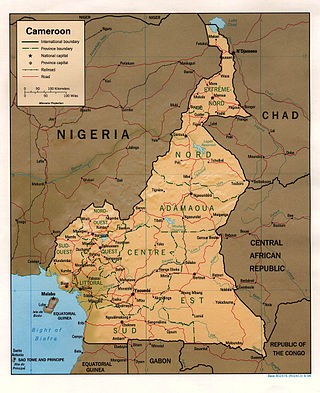
At 475,440 km2 (183,570 sq mi), Cameroon is the world's 53rd largest country. It is slightly larger than the nation of Sweden and the US state of California. It is comparable in size to Papua New Guinea. Cameroon's landmass is 472,710 km2 (182,510 sq mi), with 2,730 km2 (1,050 sq mi) of water.
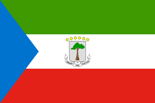
Equatorial Guinea, also rarely known as Equatoguinea, officially the Republic of Equatorial Guinea, is a country on the west coast of Central Africa, with an area of 28,000 square kilometres (11,000 sq mi). Formerly the colony of Spanish Guinea, its post-independence name refers to its location near both the Equator and in the African region of Guinea. As of 2021, the country had a population of 1,468,777, over 85% of whom are ethnically Fang.

The History of Equatorial Guinea is marked by centuries of colonial domination by the Portuguese, British and Spanish colonial empires, and by the local kingdoms.

Gabon is a country in Central Africa, lying along the Atlantic Ocean, just south of the Bight of Biafra.

The Gulf of Guinea is the northeasternmost part of the tropical Atlantic Ocean from Cape Lopez in Gabon, north and west to Cape Palmas in Liberia. The intersection of the Equator and Prime Meridian is in the gulf.

Malabo is the capital of Equatorial Guinea and the province of Bioko Norte. It is located on the north coast of the island of Bioko. In 2018, the city had a population of approximately 297,000 inhabitants.

French Equatorial Africa, or the AEF, was the federation of French colonial possessions in Equatorial Africa, extending northwards from the Congo River into the Sahel, and comprising what are today the countries of Chad, the Central African Republic, the Republic of the Congo, and Gabon.

La Niña is an oceanic and atmospheric phenomenon that is the colder counterpart of El Niño, as part of the broader El Niño–Southern Oscillation (ENSO) climate pattern. The name La Niña originates from Spanish for "the girl", by analogy to El Niño, meaning "the boy". In the past, it was also called an anti-El Niño and El Viejo, meaning "the old man."

Tropical and subtropical moist broadleaf forests (TSMF), also known as tropical moist forest, is a subtropical and tropical forest habitat type defined by the World Wide Fund for Nature.

The Intertropical Convergence Zone, known by sailors as the doldrums or the calms because of its monotonous windless weather, is the area where the northeast and the southeast trade winds converge. It encircles Earth near the thermal equator though its specific position varies seasonally. When it lies near the geographic Equator, it is called the near-equatorial trough. Where the ITCZ is drawn into and merges with a monsoonal circulation, it is sometimes referred to as a monsoon trough, a usage that is more common in Australia and parts of Asia.
Ubangi-Shari was a French colony in central Africa, a part of French Equatorial Africa.
Sarh, formerly French colonial Fort Archambault, is the capital of the Moyen-Chari Region and of the Department of Barh Köh in Chad.

Bata is a port city in the Litoral province of Equatorial Guinea. With a 2005 estimated population of 173,046, it is the second largest city in Equatorial Guinea, after Malabo. It lies on the Atlantic Ocean coast of Río Muni. Bata was formerly capital of Equatorial Guinea and is a transport hub and port, from which ferries sail to Malabo and Douala, while aircraft can land at Bata Airport. Bata is also known for its nightlife and market.

Obuasi is a gold mining community and town which is the capital of the Obuasi Municipal District in the Ashanti Region of Ghana. It lies in the southern part of the Obuasi Municipal, 39 miles south-west of Ashanti capital city Kumasi. Obuasi has a population of 175,043 people. Obuasi mining community has a mixture of the Ashanti people culture and the semi-island exclave Ashantiland.

The Congolian rainforests are a broad belt of lowland tropical moist broadleaf forests which extend across the basin of the Congo River and its tributaries in Central Africa. They are the only major rainforests which absorb more carbon than they emit.

The Atlantic Equatorial coastal forests, also known as the Congolian coastal forests, are a tropical moist broadleaf forest ecoregion of Central Africa, covering hills, plains, and mountains of the Atlantic coast of Cameroon, Equatorial Guinea, Gabon, Republic of the Congo, Angola, and Democratic Republic of the Congo.
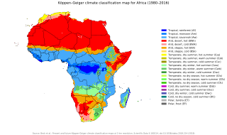
The climate of Africa is a range of climates such as the equatorial climate, the tropical wet and dry climate, the tropical monsoon climate, the semi-arid climate, the desert climate, the humid subtropical climate, and the subtropical highland climate. Temperate climates are rare across the continent except at very high elevations and along the fringes. In fact, the climate of Africa is more variable by rainfall amount than by temperatures, which are consistently high. African deserts are the sunniest and the driest parts of the continent, owing to the prevailing presence of the subtropical ridge with subsiding, hot, dry air masses. Africa holds many heat-related records: the continent has the hottest extended region year-round, the areas with the hottest summer climate, the highest sunshine duration, and more.
Djibloho – Ciudad de la Paz, formerly Oyala, is a city in Equatorial Guinea that is being built to replace Malabo as the national capital. Established as an urban district in Wele-Nzas in 2015, it is now the administrative headquarters of Djibloho, Equatorial Guinea's newest province created in 2017, and is located near the town of Mengomeyén. In 2017, the city was officially renamed Ciudad de la Paz.

The 2014–2016 El Niño was a warming of the eastern equatorial Pacific Ocean that resulted in unusually warm waters developing between the coast of South America and the International Date Line. These unusually warm waters influenced the world's weather in a number of ways, which in turn significantly affected various parts of the world. These included drought conditions in Venezuela, Australia and a number of Pacific islands while significant flooding was also recorded. During the event, more tropical cyclones than normal occurred within the Pacific Ocean, while fewer than normal occurred in the Atlantic Ocean.

The COVID-19 pandemic in Equatorial Guinea was a part of the worldwide pandemic of coronavirus disease 2019 caused by severe acute respiratory syndrome coronavirus 2. The virus was confirmed to have reached Equatorial Guinea on 14 March 2020. Equatorial Guinea has a weak healthcare system, leaving it vulnerable to an outbreak.
