
Orogeny is a mountain-building process that takes place at a convergent plate margin when plate motion compresses the margin. An orogenic belt or orogen develops as the compressed plate crumples and is uplifted to form one or more mountain ranges. This involves a series of geological processes collectively called orogenesis. These include both structural deformation of existing continental crust and the creation of new continental crust through volcanism. Magma rising in the orogen carries less dense material upwards while leaving more dense material behind, resulting in compositional differentiation of Earth's lithosphere. A synorogenic process or event is one that occurs during an orogeny.

The African plate, also known as the Nubian plate, is a major tectonic plate that includes much of the continent of Africa and the adjacent oceanic crust to the west and south. It also includes a narrow strip of Western Asia along the Mediterranean Sea, including much of Israel and Lebanon. It is bounded by the North American plate and South American plate to the west ; the Arabian plate and Somali plate to the east; the Eurasian plate, Aegean Sea plate and Anatolian plate to the north; and the Antarctic plate to the south.

The Alboran Sea is the westernmost portion of the Mediterranean Sea, lying between the Iberian Peninsula and the north of Africa. The Strait of Gibraltar, which lies at the west end of the Alboran Sea, connects the Mediterranean with the Atlantic Ocean.
An orogenic belt, orogen, or mobile belt, is a zone of Earth's crust affected by orogeny. An orogenic belt develops when a continental plate crumples and is uplifted to form one or more mountain ranges; this involves a series of geological processes collectively called orogenesis.

A foreland basin is a structural basin that develops adjacent and parallel to a mountain belt. Foreland basins form because the immense mass created by crustal thickening associated with the evolution of a mountain belt causes the lithosphere to bend, by a process known as lithospheric flexure. The width and depth of the foreland basin is determined by the flexural rigidity of the underlying lithosphere, and the characteristics of the mountain belt. The foreland basin receives sediment that is eroded off the adjacent mountain belt, filling with thick sedimentary successions that thin away from the mountain belt. Foreland basins represent an endmember basin type, the other being rift basins. Space for sediments is provided by loading and downflexure to form foreland basins, in contrast to rift basins, where accommodation space is generated by lithospheric extension.

The geology of the Iberian Peninsula consists of the study of the rock formations on the Iberian Peninsula, connected to the rest of the European landmass by the Pyrenees. The peninsula contains rocks from every geological period from the Ediacaran to the Quaternary, and many types of rock are represented. World-class mineral deposits are also found there.

An accretionary wedge or accretionary prism forms from sediments accreted onto the non-subducting tectonic plate at a convergent plate boundary. Most of the material in the accretionary wedge consists of marine sediments scraped off from the downgoing slab of oceanic crust, but in some cases the wedge includes the erosional products of volcanic island arcs formed on the overriding plate.
The Azores–Gibraltar transform fault (AGFZ), also called a fault zone and a fracture zone, is a major seismic zone in the eastern Atlantic Ocean between the Azores and the Strait of Gibraltar. It is the product of the complex interaction between the African, Eurasian, and Iberian plates. The AGFZ produced these large-magnitude earthquakes and, consequently, a number of large tsunamis: 1755 Lisbon, 1761 Lisbon, 1816 North Atlantic, 1941 Gloria Fault earthquake, 1969 Horseshoe and 1975.

In the geology of the Philippines, the Philippine Mobile Belt is a complex portion of the tectonic boundary between the Eurasian plate and the Philippine Sea plate, comprising most of the country of the Philippines. It includes two subduction zones, the Manila Trench to the west and the Philippine Trench to the east, as well as the Philippine fault system. Within the Belt, a number of crustal blocks or microplates which have been shorn off the adjoining major plates are undergoing massive deformation.

The Andean orogeny is an ongoing process of orogeny that began in the Early Jurassic and is responsible for the rise of the Andes mountains. The orogeny is driven by a reactivation of a long-lived subduction system along the western margin of South America. On a continental scale the Cretaceous and Oligocene were periods of re-arrangements in the orogeny. The details of the orogeny vary depending on the segment and the geological period considered.
Tectonic subsidence is the sinking of the Earth's crust on a large scale, relative to crustal-scale features or the geoid. The movement of crustal plates and accommodation spaces produced by faulting brought about subsidence on a large scale in a variety of environments, including passive margins, aulacogens, fore-arc basins, foreland basins, intercontinental basins and pull-apart basins. Three mechanisms are common in the tectonic environments in which subsidence occurs: extension, cooling and loading.

The Carpathian Flysch Belt is an arcuate tectonic zone included in the megastructural elevation of the Carpathians on the external periphery of the mountain chain. Geomorphologically it is a portion of the Outer Carpathians. Geologically it is a thin-skinned thrust belt or accretionary wedge, formed by rootless nappes consisting of so-called flysch – alternating marine deposits of claystones, shales and sandstones which were detached from their substratum and moved tens of kilometers to the north (generally). The Flysch Belt is together with Neogene volcanic complexes the only extant tectonic zone along the whole Carpathian arc.
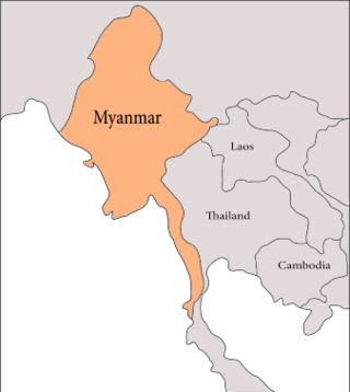
The geology of Myanmar is shaped by dramatic, ongoing tectonic processes controlled by shifting tectonic components as the Indian Plate slides northwards and towards Southeast Asia. Myanmar spans across parts of three tectonic plates separated by north-trending faults. To the west, a highly oblique subduction zone separates the offshore Indian Plate from the Burma microplate, which underlies most of the country. In the center-east of Myanmar, a right lateral strike slip fault extends from south to north across more than 1,000 km (620 mi). These tectonic zones are responsible for large earthquakes in the region. The India-Eurasia plate collision which initiated in the Eocene provides the last geological pieces of Myanmar, and thus Myanmar preserves a more extensive Cenozoic geological record as compared to records of the Mesozoic and Paleozoic eras. Myanmar is physiographically divided into three regions: the Indo-Burman Range, Myanmar Central Belt and the Shan Plateau; these all display an arcuate shape bulging westwards. The varying regional tectonic settings of Myanmar not only give rise to disparate regional features, but also foster the formation of petroleum basins and a diverse mix of mineral resources.

Divergent double subduction, also called outward dipping double-sided subduction, is a special type of subduction process in which two parallel subduction zones with different directions are developed on the same oceanic plate. In conventional plate tectonics theory, an oceanic plate subducts under another plate and new oceanic crust is generated somewhere else, commonly along the other side of the same plates However, in divergent double subduction, the oceanic plate subducts on two sides. This results in the closure of ocean and arc–arc collision.
The geology of Sicily records the collision of the Eurasian and the African plates during westward-dipping subduction of the African slab since late Oligocene. Major tectonic units are the Hyblean foreland, the Gela foredeep, the Apenninic-Maghrebian orogen, and the Calabrian Arc. The orogen represents a fold-thrust belt that folds Mesozoic carbonates, while a major volcanic unit is found in an eastern portion of the island. The collision of Africa and Eurasia is a retreating subduction system, such that the descending Africa is falling away from Eurasia, and Eurasia extends and fills the space as the African plate falls into the mantle, resulting in volcanic activity in Sicily and the formation of Tyrrhenian slab to the north.

The subduction tectonics of the Philippines is the control of geology over the Philippine archipelago. The Philippine region is seismically active and has been progressively constructed by plates converging towards each other in multiple directions. The region is also known as the Philippine Mobile Belt due to its complex tectonic setting.
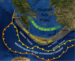
The Hellenic subduction zone (HSZ) is the convergent boundary between the African plate and the Aegean Sea plate, where oceanic crust of the African is being subducted north–northeastwards beneath the Aegean. The southernmost and shallowest part of the zone is obscured beneath the deformed thick sedimentary sequence that forms the Mediterranean Ridge accretionary complex. It has a well-defined Wadati–Benioff zone of seismicity, which demonstrates the relatively shallow dip of its southern part, which increases markedly to the north of the non-volcanic part of the Hellenic arc. The descending slab has been imaged using seismic tomography down to the top of the mantle transition zone at 410 km depth.

The Ordos Block is a crustal block, that forms part of the larger North China Block (NCB). It is surrounded by active fault systems and has been a distinct block since at least the Mesozoic. It is bordered to the west by the Alxa Block, the westernmost part of the NCB, to the south by the Qinling orogenic belt, to the north by the Yanshan-Yinshan orogenic belt, part of the Central Asian Orogenic Belt and to the east by the Taihangshan mountain range, which forms part of the Trans-North China Orogen. The block is currently stable and large earthquakes are restricted to the bordering fault zones. It has been suggested that the block is currently undergoing anti-clockwise rotation with respect to the Eurasian Plate, as a result of the ongoing eastward spreading of the Tibetan Plateau, although this view has been challenged.
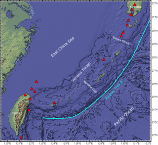
The Ryukyu Arc is an island arc which extends from the south of Kyushu along the Ryukyu Islands to the northeast of Taiwan, spanning about 1,200 kilometres (750 mi). It is located along a section of the convergent plate boundary where the Philippine Sea Plate is subducting northwestward beneath the Eurasian Plate along the Ryukyu Trench. The arc has an overall northeast to southwest trend and is located northwest of the Pacific Ocean and southeast of the East China Sea. It runs parallel to the Okinawa Trough, an active volcanic arc, and the Ryukyu Trench. The Ryukyu Arc, based on its geomorphology, can be segmented from north to south into Northern Ryukyu, Central Ryukyu, and Southern Ryukyu; the Tokara Strait separates Northern Ryukyu and Central Ryukyu at about 130˚E while the Kerama Gap separates Central Ryukyu and Southern Ryukyu at about 127 ˚E. The geological units of the arc include igneous, sedimentary, and metamorphic rocks, ranging from the Paleozoic to Cenozoic in age.
In 1624 the city of Fez in northern Morocco was devastated by a major earthquake between three and four in the morning of 11 May. It had an estimated magnitude of 6.0 and a maximum felt intensity of VIII–IX on the MSK scale. The earthquake caused severe damage in Fez and the surrounding area. It was felt as far away as Seville in southern Spain. Thousands of people died.

