Map of the "Old World" (the 2nd-century Ptolemy world map in a 15th-century copy)This T and O map, from the first printed version of Isidore's Etymologiae (Augsburg, 1472), identifies the three known continents (Asia, Europe and Africa) as respectively populated by descendants of Sem (Shem), Iafeth (Japheth) and Cham (Ham).
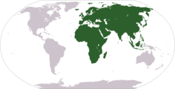
The "Old World" (Latin: Mundus vetus) is a Eurocentric term for Afro-Eurasia coined by Europeans after 1493, when they became aware of the existence of the Americas and Oceania.[1] It is used to contrast the continents of Asia, Europe, and Africa in the Eastern Hemisphere, previously thought of by the Europeans as comprising the entire world, with the "New World", a term for the newly encountered lands of the Western Hemisphere, being the Americas And Oceania.[2][3]
This page is based on this Wikipedia article Text is available under the CC BY-SA 4.0 license; additional terms may apply. Images, videos and audio are available under their respective licenses.