Rodinia was a Mesoproterozoic and Neoproterozoic supercontinent that assembled 1.26–0.90 billion years ago (Ga) and broke up 750–633 million years ago (Ma). Valentine & Moores 1970 were probably the first to recognise a Precambrian supercontinent, which they named "Pangaea I." It was renamed "Rodinia" by McMenamin & McMenamin 1990, who also were the first to produce a plate reconstruction and propose a temporal framework for the supercontinent.

Laurasia was the more northern of two large landmasses that formed part of the Pangaea supercontinent from around 335 to 175 million years ago (Mya), the other being Gondwana. It separated from Gondwana 215 to 175 Mya during the breakup of Pangaea, drifting farther north after the split and finally broke apart with the opening of the North Atlantic Ocean c. 56 Mya. The name is a portmanteau of Laurentia and Eurasia.

Panthalassa, also known as the Panthalassic Ocean or Panthalassan Ocean, was the vast superocean that encompassed planet Earth and surrounded the supercontinent Pangaea, the latest in a series of supercontinents in the history of Earth. During the Paleozoic–Mesozoic transition, the ocean occupied almost 70% of Earth's surface, with the supercontinent Pangaea taking up less than half. The original, ancient ocean floor has now completely disappeared because of the continuous subduction along the continental margins on its circumference. Panthalassa is also referred to as the Paleo-Pacific or Proto-Pacific because the Pacific Ocean is a direct continuation of Panthalassa.

The Mesoproterozoic Era is a geologic era that occurred from 1,600 to 1,000 million years ago. The Mesoproterozoic was the first era of Earth's history for which a fairly definitive geological record survives. Continents existed during the preceding era, but little is known about them. The continental masses of the Mesoproterozoic were more or less the same ones that exist today, although their arrangement on the Earth's surface was different.

The Iapetus Ocean existed in the late Neoproterozoic and early Paleozoic eras of the geologic timescale. It was in the southern hemisphere, between the paleocontinents of Laurentia, Baltica and Avalonia. The ocean disappeared with the Acadian, Caledonian and Taconic orogenies, when these three continents joined to form one big landmass called Euramerica. The "southern" Iapetus Ocean has been proposed to have closed with the Famatinian and Taconic orogenies, meaning a collision between Western Gondwana and Laurentia.

Pannotia, also known as the Vendian supercontinent, Greater Gondwana, and the Pan-African supercontinent, was a relatively short-lived Neoproterozoic supercontinent that formed at the end of the Precambrian during the Pan-African orogeny, during the Cryogenian period and broke apart 560 Ma with the opening of the Iapetus Ocean, in the late Ediacaran and early Cambrian. Pannotia formed when Laurentia was located adjacent to the two major South American cratons, Amazonia and Río de la Plata. The opening of the Iapetus Ocean separated Laurentia from Baltica, Amazonia, and Río de la Plata. A 2022 paper argues that Pannotia never fully existed, reinterpreting the geochronological evidence: "the supposed landmass had begun to break up well before it was fully assembled". However, the assembly of the next supercontinent Pangaea is well established.

Baltica is a paleocontinent that formed in the Paleoproterozoic and now constitutes northwestern Eurasia, or Europe north of the Trans-European Suture Zone and west of the Ural Mountains. The thick core of Baltica, the East European Craton, is more than three billion years old and formed part of the Rodinia supercontinent at c. 1 Ga.

Avalonia was a microcontinent in the Paleozoic era. Crustal fragments of this former microcontinent underlie south-west Great Britain, southern Ireland, and the eastern coast of North America. It is the source of many of the older rocks of Western Europe, Atlantic Canada, and parts of the coastal United States. Avalonia is named for the Avalon Peninsula in Newfoundland.

The Congo Craton, covered by the Palaeozoic-to-recent Congo Basin, is an ancient Precambrian craton that with four others makes up the modern continent of Africa. These cratons were formed between about 3.6 and 2.0 billion years ago and have been tectonically stable since that time. All of these cratons are bounded by younger fold belts formed between 2.0 billion and 300 million years ago.
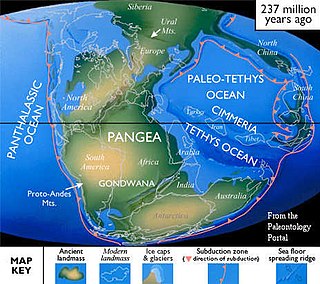
Cimmeria was an ancient continent, or, rather, a string of microcontinents or terranes, that rifted from Gondwana in the Southern Hemisphere and was accreted to Eurasia in the Northern Hemisphere. It consisted of parts of present-day Turkey, Iran, Afghanistan, Pakistan, Tibet, China, Myanmar, Thailand, and Malaysia. Cimmeria rifted from the Gondwanan shores of the Paleo-Tethys Ocean during the Early Permian and as the Neo-Tethys Ocean opened behind it, during the Permian, the Paleo-Tethys closed in front of it. Because the different chunks of Cimmeria drifted northward at different rates, a Meso-Tethys Ocean formed between the different fragments during the Cisuralian. Cimmeria rifted off Gondwana from east to west, from Australia to the eastern Mediterranean. It stretched across several latitudes and spanned a wide range of climatic zones.

Gondwana was a large landmass, sometimes referred to as a supercontinent. The remnants of Gondwana make up around two-thirds of today's continental area, including South America, Africa, Antarctica, Australia, Zealandia, Arabia, and the Indian subcontinent.
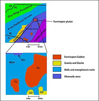
The Carolina Terrane, also called the Carolina Superterrane or Carolinia, is an exotic terrane running ~370 miles (600 km) approximately North-South from central Georgia to central Virginia in the United States. It constitutes a major part of the eastern Piedmont Province.
This is a list of articles related to plate tectonics and tectonic plates.
Pampia was an ancient microcontinent or terrane that collided with Río de la Plata Craton and Río Apas Craton during the Pampean orogeny of late Proterozoic and early Cambrian. It was one of the first terranes to be amalgamated to the old cratons of the east, and was followed by the suturing of Cuyania and Chilenia terranes into the young South American Plate.
The Shan–Thai or Sibumasu terrane is a mass of continental crust extending from Tibet into Southeast Asia sharing a similar geological history. The Shan–Thai terrane rifted from Australia in the Permian and collided with the Indochina terrane in the Triassic. It extends from Malaysia, through peninsular Thailand, Myanmar, West Yunnan, to Lhasa.

The Huangling Anticline or Complex represents a group of rock units that appear in the middle of the Yangtze Block in South China, distributed across Yixingshan, Zigui, Huangling, and Yichang counties. The group of rock involves nonconformity that sedimentary rocks overlie the metamorphic basement. It is a 73-km long, asymmetrical dome-shaped anticline with axial plane orientating in the north-south direction. It has a steeper west flank and a gentler east flank. Basically, there are three tectonic units from the anticline core to the rim, including Archean to Paleoproterozoic metamorphic basement, Neoproterozoic to Jurassic sedimentary rocks, and Cretaceous fluvial deposit sedimentary cover. The northern part of the core is mainly tonalite-trondhjemite-gneiss (TTG) and Cretaceous sedimentary rock called the Archean Kongling Complex. The middle of the core is mainly the Neoproterozoic granitoid. The southern part of the core is the Neoproterozoic potassium granite. Two basins are situated on the western and eastern flanks of the core, respectively, including the Zigui basin and Dangyang basin. Both basins are synforms while Zigui basin has a larger extent of folding. Yuanan Graben and Jingmen Graben are found within the Dangyang Basin area. The Huangling Anticline is an important area that helps unravel the tectonic history of the South China Craton because it has well-exposed layers of rock units from Archean basement rock to Cretaceous sedimentary rock cover due to the erosion of the anticline.

The Qinling orogenic belt is a tectonic feature that evolved throughout the Proterozoic and Phanerozoic eons due to a variety of tectonic activities. It is a part of the Central China Orogenic Belt, aligned in an east–west orientation across Central China, and spans portions of Shaanxi, Henan and Gansu provinces along the Qinling Mountains which are one of the greatest mountain ranges in China. The first materials involved in the Qinling orogenic belt formed around 2.5 billion years ago, whereas the main morphology of the belt now largely reflects the Triassic collision between the North China Plate and the South China Plate and Cenozoic extension across China. During these 2.5 billion years, various types of rocks have been formed here due to different tectonic processes and chemical reactions between rocks. Therefore, geologists are able to reconstruct the evolution of mountain belt based on evidence preserved in these rocks.
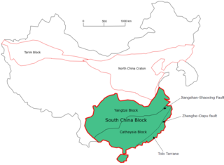
The South China Craton or South China Block is one of the Precambrian continental blocks in China. It is traditionally divided into the Yangtze Block in the NW and the Cathaysia Block in the SE. The Jiangshan–Shaoxing Fault represents the suture boundary between the two sub-blocks. Recent study suggests that the South China Block possibly has one more sub-block which is named the Tolo Terrane. The oldest rocks in the South China Block occur within the Kongling Complex, which yields zircon U–Pb ages of 3.3–2.9 Ga.
A continent is a large geographical region defined by the continental shelves and the cultures on the continent. In the modern day, there are seven continents. However, there have been more continents throughout history. Vaalbara was the first supercontinent. Europe is the newest continent. Geologists have predicted that certain continents will appear, these being Pangaea Proxima, Novopangaea, Aurica, and Amasia.


