Related Research Articles
The Cambrian is the first geological period of the Paleozoic Era, and the Phanerozoic Eon. The Cambrian lasted 53.4 million years from the end of the preceding Ediacaran period 538.8 Ma to the beginning of the Ordovician Period 485.4 Ma.
The Ordovician is a geologic period and system, the second of six periods of the Paleozoic Era, and the second of twelve periods of the Phanerozoic Eon. The Ordovician spans 41.6 million years from the end of the Cambrian Period 485.4 Ma to the start of the Silurian Period 443.8 Ma.

Laurasia was the more northern of two large landmasses that formed part of the Pangaea supercontinent from around 335 to 175 million years ago (Mya), the other being Gondwana. It separated from Gondwana 215 to 175 Mya during the breakup of Pangaea, drifting farther north after the split and finally broke apart with the opening of the North Atlantic Ocean c. 56 Mya. The name is a portmanteau of Laurentia and Asia.

The Iapetus Ocean existed in the late Neoproterozoic and early Paleozoic eras of the geologic timescale. It was in the southern hemisphere, between the paleocontinents of Laurentia, Baltica and Avalonia. The ocean disappeared with the Acadian, Caledonian and Taconic orogenies, when these three continents joined to form one big landmass called Euramerica. The "southern" Iapetus Ocean has been proposed to have closed with the Famatinian and Taconic orogenies, meaning a collision between Western Gondwana and Laurentia.

Baltica is a paleocontinent that formed in the Paleoproterozoic and now constitutes northwestern Eurasia, or Europe north of the Trans-European Suture Zone and west of the Ural Mountains. The thick core of Baltica, the East European Craton, is more than three billion years old and formed part of the Rodinia supercontinent at c. 1 Ga.

Avalonia was a microcontinent in the Paleozoic era. Crustal fragments of this former microcontinent underlie south-west Great Britain, southern Ireland, and the eastern coast of North America. It is the source of many of the older rocks of Western Europe, Atlantic Canada, and parts of the coastal United States. Avalonia is named for the Avalon Peninsula in Newfoundland.

The Caledonian orogeny was a mountain-building cycle recorded in the northern parts of the British Isles, the Scandinavian Caledonides, Svalbard, eastern Greenland and parts of north-central Europe. The Caledonian orogeny encompasses events that occurred from the Ordovician to Early Devonian, roughly 490–390 million years ago (Ma). It was caused by the closure of the Iapetus Ocean when the Laurentia and Baltica continents and the Avalonia microcontinent collided.
The Uralian orogeny refers to the long series of linear deformation and mountain building events that raised the Ural Mountains, starting in the Late Carboniferous and Permian periods of the Palaeozoic Era, c. 323–299 and 299–251 million years ago (Mya) respectively, and ending with the last series of continental collisions in Triassic to early Jurassic times.
The Rheic Ocean was an ocean which separated two major paleocontinents, Gondwana and Laurussia (Laurentia-Baltica-Avalonia). One of the principal oceans of the Paleozoic, its sutures today stretch 10,000 km (6,200 mi) from Mexico to Turkey and its closure resulted in the assembly of the supercontinent Pangaea and the formation of the Variscan–Alleghenian–Ouachita orogenies.
The Proto-Tethys or Theic Ocean was an ancient ocean that existed from the latest Ediacaran to the Carboniferous.

Gondwana was a large landmass, sometimes referred to as a supercontinent. The remnants of Gondwana make up around two-thirds of today's continental area, including South America, Africa, Antarctica, Australia, Zealandia, Arabia, and the Indian Subcontinent.

Laurentia or the North American Craton is a large continental craton that forms the ancient geological core of North America. Many times in its past, Laurentia has been a separate continent, as it is now in the form of North America, although originally it also included the cratonic areas of Greenland and the Hebridean Terrane in northwest Scotland. During other times in its past, Laurentia has been part of larger continents and supercontinents and consists of many smaller terranes assembled on a network of early Proterozoic orogenic belts. Small microcontinents and oceanic islands collided with and sutured onto the ever-growing Laurentia, and together formed the stable Precambrian craton seen today.

Pangaea or Pangea was a supercontinent that existed during the late Paleozoic and early Mesozoic eras. It assembled from the earlier continental units of Gondwana, Euramerica and Siberia during the Carboniferous approximately 335 million years ago, and began to break apart about 200 million years ago, at the end of the Triassic and beginning of the Jurassic. Pangaea was C-shaped, with the bulk of its mass stretching between Earth's northern and southern polar regions and surrounded by the superocean Panthalassa and the Paleo-Tethys and subsequent Tethys Oceans. Pangaea is the most recent supercontinent to have existed and the first to be reconstructed by geologists.
This is a list of articles related to plate tectonics and tectonic plates.

The Armorican terrane, Armorican terrane assemblage, or simply Armorica, was a microcontinent or group of continental fragments that rifted away from Gondwana towards the end of the Silurian and collided with Laurussia towards the end of the Carboniferous during the Variscan orogeny. The name is taken from Armorica, the Gaulish name for a large part of northwestern France that includes Brittany, as this matches closely to the present location of the rock units that form the main part of this terrane.
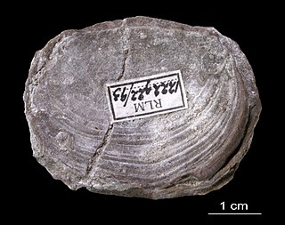
Trimerellida is an extinct order of craniate brachiopods, containing the sole superfamily Trimerelloidea and the families Adensuidae, Trimerellidae, and Ussuniidae. Trimerellidae was a widespread family of warm-water brachiopods ranging from the Middle Ordovician to the late Silurian (Ludlow). Adensuidae and Ussuniidae are monogeneric families restricted to the Ordovician of Kazakhstan. Most individuals were free-living, though some clustered into large congregations similar to modern oyster reefs.
Ganderia or Gander Terrane is a terrane in the northern Appalachians which broke off the supercontinent Gondwana c.570 million years ago (Ma) together with Avalonia, Megumia, and Carolinia.

The Central Asian Orogenic Belt (CAOB), also called the Altaids, is one of the world's largest Phanerozoic accretionary orogens, and thus a leading laboratory of geologically recent crustal growth. The orogenic belt is bounded by the East European Craton and the North China Craton in the Northwest-Southeast direction, as well as Siberia Craton and Tarim Craton in the Northeast-Southwest direction. It formed by ocean closures during Neoproterozoic to the late Phanerozoic time, from around 750 to 150 Ma. Like many other accretionary orogenic belts, the Central Asian Orogenic Belt consists of a huge amount of magmatic arcs, arc-related basins, accretionary complexes, seamounts, continental fragments and ophiolites. It is also considered a relatively distinctive collisional orogenic belt because widespread subduction-accretion complexes and arc magmatic rocks can be found in the region, but collision-related foreland basins are not common.
References
Notes
- ↑ Popov & Cocks 2017 , Introduction, pp. 323, 325
- ↑ Popov & Cocks 2017 , Late Ordovician Global Geography, pp. 325–327
- ↑ Torsvik & Cocks 2009 , pp. 8–9
- ↑ Popov & Cocks 2006 , p. 247
- ↑ Popov & Cocks 2006 , p. 254
- ↑ Popov & Cocks 2017 , Abstract; For a map of the Kazakh terranes see Popov & Cocks 2006 , Fig. 1, p. 248; For a Late Ordovician reconstruction see Percival et al. 2011 , Fig. 1, p. 414
Sources
- Percival, I. G.; Popov, L. E.; Zhan, R. B.; Ghobadi Pour, M. (2011). "Patterns of origination and dispersal of Middle to Late Ordovician brachiopods: examples from South China, East Gondwana, and Kazakh terranes". In Gutiérrez-Marco, J. C.; Rábano, I.; García-Bellido, D. (eds.). Ordovician of the World. Cuadernos del Museo Geominero. Vol. 14. Madrid: Instituto Geológico y Minero de Espana. pp. 413–419. ISBN 9788478408573 . Retrieved 27 December 2017.
- Popov, L. E.; Cocks, L. R. M. (2006). "Late Ordovician brachiopods from the Dulankara Formation of the Chu-Ili Range, Kazakhstan: their systematics, palaeoecology and palaeobiogeography". Palaeontology. 49 (2): 247–283. Bibcode:2006Palgy..49..247P. doi: 10.1111/j.1475-4983.2006.00544.x . S2CID 129492176.
- Popov, L. E.; Cocks, R. M. (2017). "Late Ordovician palaeogeography and the positions of the Kazakh terranes through analysis of their brachiopod faunas" (PDF). Acta Geologica Polonica. 67 (3): 323–380. doi: 10.1515/agp-2017-0020 . Retrieved 27 December 2017.
- Torsvik, T. H.; Cocks, L. R. M. (2009). "The Lower Palaeozoic palaeogeographical evolution of the northeastern and eastern peri-Gondwanan margin from Turkey to New Zealand". Geological Society, London, Special Publications. 325 (1): 3–21. doi:10.1144/SP325.2. S2CID 128490493 . Retrieved 27 December 2017.


