The Amu Darya, also called the Amu, the Amo, and historically the Oxus, is a major river in Central Asia and Afghanistan. Rising in the Pamir Mountains, north of the Hindu Kush, the Amu Darya is formed by the confluence of the Vakhsh and Panj rivers, in the Tigrovaya Balka Nature Reserve on the border between Afghanistan and Tajikistan, and flows from there north-westwards into the southern remnants of the Aral Sea. In its upper course, the river forms part of Afghanistan's northern border with Tajikistan, Uzbekistan, and Turkmenistan. In ancient history, the river was regarded as the boundary of Greater Iran with Turan, which roughly corresponded to present-day Central Asia. The Amu Darya has a flow of about 70 cubic kilometres per year on average.

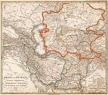
Central Asia is a subregion of Asia that stretches from the Caspian Sea in the southwest and Eastern Europe in the northwest to Western China and Mongolia in the east, and from Afghanistan and Iran in the south to Russia in the north. It includes the former Soviet republics of Kazakhstan, Kyrgyzstan, Tajikistan, Turkmenistan, and Uzbekistan. The countries as a group are also colloquially referred to as the "-stans" as all have names ending with the Persian suffix "-stan" in both respective native languages and most other languages.

Kazakhstan is located in Central Asia. With an area of about 2,724,900 square kilometers (1,052,100 sq mi) Kazakhstan is more than twice the combined size of the other four Central Asian states and 60% larger than Alaska. The country borders Turkmenistan, Uzbekistan, and Kyrgyzstan to the south; Russia to the north; Russia and the Caspian Sea to the west; and China's Xinjiang Uygur Autonomous Region to the east.
Turkmenistan is a landlocked country in Central Asia, bordering the Caspian Sea to the west, Iran and Afghanistan to the south, Uzbekistan to the north-east, and Kazakhstan to the north-west. It is the southernmost republic of the Commonwealth of Independent States (CIS), the loose federation created at the end of 1991 by most of the Post-Soviet states.
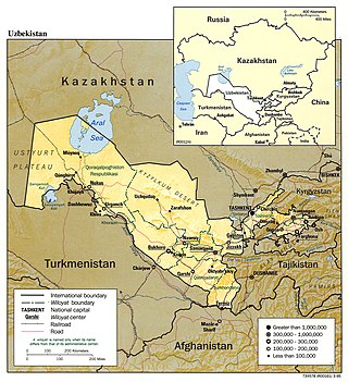
Uzbekistan is a country in Central Asia, located north of Turkmenistan and Afghanistan. With an area of 447,000 square kilometers, Uzbekistan stretches 1,425 km (885 mi) from west to east and 930 km (580 mi) from north to south. It borders Turkmenistan to the southwest, Kazakhstan to the north and Tajikistan and Kyrgyzstan to the south and east. Uzbekistan also has four small exclaves in Turkmenistan.

The Aral Sea was an endorheic lake lying between Kazakhstan to its north and Uzbekistan to its south which began shrinking in the 1960s and largely dried up by the 2010s. It was in the Aktobe and Kyzylorda regions of Kazakhstan and the Karakalpakstan autonomous region of Uzbekistan. The name roughly translates from Mongolic and Turkic languages to "Sea of Islands", a reference to the large number of islands that once dotted its waters. The Aral Sea drainage basin encompasses Uzbekistan and parts of Afghanistan, Iran, Kazakhstan, Kyrgyzstan, Tajikistan, and Turkmenistan.

The Karakum Desert, also spelled Kara-Kum and Gara-Gum, is a desert in Central Asia. The name refers to the shale-rich sand beneath the surface. It occupies about 70 percent, or roughly 350,000 km2 (140,000 sq mi), of Turkmenistan.
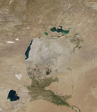
The Aralkum Desert is a desert that has appeared since 1960 on the seabed once occupied by the Aral Sea. It lies to the south and east of what remains of the Eastern Basin Aral Sea in Uzbekistan and Kazakhstan. It is currently the youngest desert in the world.
Daşoguz, formerly known as Tashauz and Dashkhovuz, is a city in northern Turkmenistan and the capital of Daşoguz Province. The Uzbekistan border is about 10 km away.

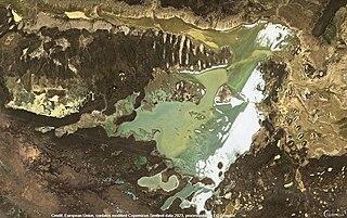
The Sarygamysh Lake, also Sarykamysh or Sary-Kamysh, is a lake in Central Asia. It is about midway between the Caspian Sea and the Aral Sea. It is the largest lake in Turkmenistan, in which three quarters of the entire lake's area is located. The Sarykamysh basin and the Sarykamysh delta of the Amu Darya river are physical and geographical nature regions of the Dashoguz Region of Turkmenistan.

The Caspian Depression or Pricaspian/Peri-Caspian Depression/Lowland is a low-lying flatland region encompassing the northern part of the Caspian Sea, the largest enclosed body of water on Earth. It is the larger northern part of the wider Aral-Caspian Depression around the Aral and Caspian Seas.

The Kazakh Steppe, also called the Great Dala, is a vast region of open grassland in Central Asia, covering areas in northern Kazakhstan and adjacent areas of Russia. It lies east of the Pontic–Caspian steppe and west of the Emin Valley steppe, with which it forms the central and western part of the Eurasian steppe. The Kazakh Steppe is an ecoregion of the temperate grasslands, savannas, and shrublands biome in the Palearctic realm. Before the mid-19th century, it was called the Kirghiz steppe, 'Kirghiz' being an old Russian word for the Kazakhs.

The Aydar Lake is part of the man-made Aydar-Arnasay system of lakes, which covers 4,000 square kilometres (1,500 mi2). This has 3 brackish water lakes, deep basins of the south-eastern Kyzyl Kum. The lakes are expansive reservoirs of Soviet planning.
The Aral–Caspian Depression is a lowland depression straddling Europe and Asia around the Aral Sea and Northern Caspian Sea. The most northern part is called the Caspian Depression. The desert part to the east of the Caspian Depression and Caspian is called the Turan Depression. In Azerbaijan, the Kura-Aras Lowland is part of the Aral–Caspian Depression. Its parts lie in Azerbaijan, Russia, Kazakhstan, Uzbekistan, and Turkmenistan.
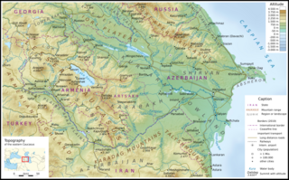
The Kura-Aras Lowland, Kura-Aras Depression or Kura-Aras Basin is a vast depression in central-southern Azerbaijan defined by the valleys of the Kura River and Aras River. It is situated by the West shore of the Caspian Sea and is part of the Aral-Caspian Depression. It is delimited by the Greater Caucasus from the North, Lesser Caucasus from the West and the Talysh Mountains from the South. The name is derived from the names of the two rivers in the area: the Kura and the Aras.

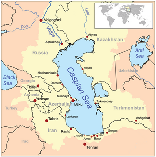
The Caspian Sea is the world's largest inland body of water, often described as the world's largest lake or a full-fledged sea. An endorheic basin, it lies between Europe and Asia: east of the Caucasus, west of the broad steppe of Central Asia, south of the fertile plains of Southern Russia in Eastern Europe, and north of the mountainous Iranian Plateau. It covers a surface area of 371,000 km2 (143,000 sq mi), an area approximately equal to that of Japan, with a volume of 78,200 km3 (19,000 cu mi). It has a salinity of approximately 1.2%, about a third of the salinity of average seawater. It is bounded by Kazakhstan to the northeast, Russia to the northwest, Azerbaijan to the southwest, Iran to the south, and Turkmenistan to the southeast.
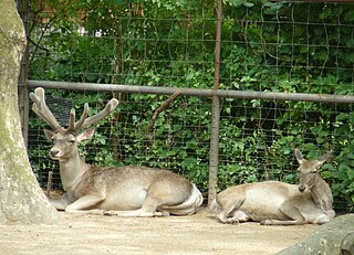
The wildlife of Turkmenistan is the flora and fauna of Turkmenistan, and the natural habitats in which they live. Turkmenistan is a country in Central Asia to the east of the Caspian Sea. Two thirds of the country is hot dry plains and desert, and the rest is more mountainous. Very little rain falls in summer and the chief precipitation occurs in the southern part of the country in the winter and spring. The Caspian coast has milder winters.
The geology of Turkmenistan includes two different geological provinces: the Karakum, or South Turan Platform, and the Alpine Orogen.

The Caspian lowland desert ecoregion covers the north and southeast coasts of the Caspian Sea, including the deltas of the Volga River and Ural River in the northern region. While the region gets relatively low amounts of precipitation, wildlife is supported by the river estuaries and the sea itself. The wetlands are an internationally important area for bird nesting and migratory resting. The ecoregion is in the Palearctic realm, and the deserts and xeric shrublands biome. It has an area of 267,300 square kilometres (103,200 sq mi).
Shalkarteniz is a salt lake in the Yrgyz District, Aktobe Region, Kazakhstan.