Salt pan (geology)

Last updated
Salt pan at Lake Karum in Ethiopia ET Afar asv2018-01 img01 Lake Karum area.jpg
Salt pan at Lake Karum in Ethiopia
Cono de Arita in Salar de Arizaro, Salta (Argentina) Cono de Arita en el Salar de Arizaro.jpg
Cono de Arita in Salar de Arizaro, Salta (Argentina)

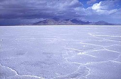
Natural salt pans or salt flats are flat expanses of ground covered with salt and other minerals, usually shining white under the sun. They are found in deserts and are natural formations (unlike salt evaporation ponds, which are artificial).

Contents

A salt pan forms by evaporation of a water pool, such as a lake or pond. This happens in climates where the rate of water evaporation exceeds the rate of precipitation that is, in a desert. If the water cannot drain into the ground, it remains on the surface until it evaporates, leaving behind minerals precipitated from the salt ions dissolved in the water. Over thousands of years, the minerals (usually salts) accumulate on the surface. [1] These minerals reflect the sun's rays (through radiation) and often appear as white areas.

Salt pans can be dangerous. The crust of salt can conceal a quagmire of mud that can engulf a truck. The Qattara Depression in the eastern Sahara Desert contains many such traps which served as strategic barriers during World War II. [2]

Devil's Golf Course, Death Valley National Park, United States Death Valley,19820817,Devil's Golf Course.jpg
Devil's Golf Course, Death Valley National Park, United States

Examples

The Bonneville Salt Flats in Utah, where many land speed records have been set, are a well-known salt pan in the arid regions of the western United States.

The Etosha pan, in the Etosha National Park in Namibia, is another prominent example of a salt pan.

The Salar de Uyuni in Bolivia is the largest salt pan in the world. It contains 50% to 70% of the world's known lithium reserves. [3] The large area, clear skies, and exceptional flatness of the surface make the Salar an ideal object for calibrating the altimeters of Earth observation satellites. [4] [5]

Parts of Rann of Kutch (India) are salt marsh in the wet season and salt pan in the dry season. [6]

See also

Related Research Articles

<span class="mw-page-title-main">Evaporite</span> Water-soluble mineral deposit formed by evaporation from an aqueous solution

An evaporite is a water-soluble sedimentary mineral deposit that results from concentration and crystallization by evaporation from an aqueous solution. There are two types of evaporite deposits: marine, which can also be described as ocean deposits, and non-marine, which are found in standing bodies of water such as lakes. Evaporites are considered sedimentary rocks and are formed by chemical sediments.

<span class="mw-page-title-main">Salar de Uyuni</span> Salt flat in Bolivia

Salar de Uyuni is the world's largest salt flat, or playa, at over 10,000 square kilometres (3,900 sq mi) in area. It is in the Daniel Campos Province in Potosí in southwest Bolivia, near the crest of the Andes at an elevation of 3,656 m (11,995 ft) above sea level.

<span class="mw-page-title-main">Endorheic basin</span> Closed drainage basin that allows no outflow

An endorheic basin is a drainage basin that normally retains water and allows no outflow to other, external bodies of water ; instead, the water drainage flows into permanent and seasonal lakes and swamps that equilibrate through evaporation. Endorheic basins also are called closed basins, terminal basins, and internal drainage systems.

<span class="mw-page-title-main">Dry lake</span> Basin or depression that formerly contained a standing surface water body

A dry lake bed, also known as a playa, is a basin or depression that formerly contained a standing surface water body, which disappears when evaporation processes exceed recharge. If the floor of a dry lake is covered by deposits of alkaline compounds, it is known as an alkali flat. If covered with salt, it is known as a salt flat.

<span class="mw-page-title-main">Lake Poopó</span> Saline lake in Bolivia

Lake Poopó was a large saline lake in a shallow depression in the Altiplano Mountains in Oruro Department, Bolivia, at an altitude of approximately 3,700 m (12,100 ft). Due to the lake's length and width, it made up the eastern half of Oruro, known as a mining region in southwest Bolivia. The permanent part of the lake body covered approximately 1,000 square kilometres (390 sq mi) and it was the second-largest lake in the country. The lake received most of its water from the Desaguadero River, which flows from Lake Titicaca at the north end of the Altiplano. Since the lake lacked any major outlet and had a mean depth of less than 3 m (10 ft), the surface area differed greatly seasonally.

<span class="mw-page-title-main">Salt lake</span> Landlocked body of water which has a high concentration of salts

A salt lake or saline lake is a landlocked body of water that has a concentration of salts and other dissolved minerals significantly higher than most lakes. In some cases, salt lakes have a higher concentration of salt than sea water; such lakes can also be termed hypersaline lakes, and may also be pink lakes on account of their colour. An alkalic salt lake that has a high content of carbonate is sometimes termed a soda lake.

<span class="mw-page-title-main">Salt evaporation pond</span> Shallow artificial pond designed to extract salts from sea water or other brines,

A salt evaporation pond is a shallow artificial salt pan designed to extract salts from sea water or other brines. The salt pans are shallow and expansive, allowing sunlight to penetrate and reach the seawater. Natural salt pans are formed through geological processes, where water evaporating, leaving behind salts deposits. Some salt evaporation ponds are only slightly modified from their natural version, such as the ponds on Great Inagua in the Bahamas, or the ponds in Jasiira, a few kilometres south of Mogadishu, where seawater is trapped and left to evaporate in the sun.

Salt pans can refer to:

<span class="mw-page-title-main">Etosha Pan</span> Big endorheic salt ville in Namibias north

The Etosha Pan is a large endorheic salt pan, forming part of the Cuvelai-Etosha Basin in the north of Namibia. It is a vast hollow in the ground in which water may collect or in which a deposit of salt remains after water has evaporated. The 120-kilometre-long (75-mile-long) dry lakebed and its surroundings are protected as Etosha National Park, Namibia's second-largest wildlife park, covering 22,270 square kilometres (8,600 sq mi). The pan is mostly dry but after heavy rains it is flooded with a thin layer of water, which is heavily salted by the mineral deposits on the surface.

<span class="mw-page-title-main">Bristol Lake</span> Lake in United States of America

Bristol Lake is a dry lake in the Mojave Desert of San Bernardino County, California, 42 km (26 mi) northeast of Twentynine Palms.

<span class="mw-page-title-main">Sabkha</span> Salt lake above the tide line, where evaporite deposits accumulate

A sabkha is a coastal, supratidal mudflat or sandflat in which evaporite-saline minerals accumulate as the result of semiarid to arid climate. Sabkhas are gradational between land and intertidal zone within restricted coastal plains just above normal high-tide level. Within a sabkha, evaporite-saline minerals sediments typically accumulate below the surface of mudflats or sandflats. Evaporite-saline minerals, tidal-flood, and aeolian deposits characterize many sabkhas found along modern coastlines. The accepted type locality for a sabkha is at the southern coast of the Persian Gulf, in the United Arab Emirates. Evidence of clastic sabkhas are found in the geological record of many areas, including the UK and Ireland. Sabkha is a phonetic transliteration of the Arabic word used to describe any form of salt flat. A sabkha is also known as a sabkhah,sebkha, or coastal sabkha.

A salt storm is a low-lying cloud of airborne salt that hovers over large areas, the result of wind sweeping over salt flats. Salt storms usually occur in places with large aboveground deposits of salt, such as those surrounding the Great Salt Lake in Utah and the Aral Sea. Salt storms are also a frequent phenomenon in the Salar de Uyuni region in Bolivia.

<span class="mw-page-title-main">Depositional environment</span> Processes associated with the deposition of a particular type of sediment

In geology, depositional environment or sedimentary environment describes the combination of physical, chemical, and biological processes associated with the deposition of a particular type of sediment and, therefore, the rock types that will be formed after lithification, if the sediment is preserved in the rock record. In most cases, the environments associated with particular rock types or associations of rock types can be matched to existing analogues. However, the further back in geological time sediments were deposited, the more likely that direct modern analogues are not available.

<span class="mw-page-title-main">Salar de Atacama</span> Salt flat in Chile

Salar de Atacama, located 55 km (34 mi) south of San Pedro de Atacama, is the largest salt flat in Chile. It is surrounded by mountains and lacks drainage outlets. To the east, it is enclosed by the main chain of the Andes, while to the west lies a secondary mountain range called Cordillera de Domeyko. The landscape is dominated by imposing volcanoes such as Licancabur, Acamarachi, Aguas Calientes, and Láscar, the latter being one of Chile's most active volcanoes. These volcanoes are situated along the eastern side of the Salar de Atacama, forming a north–south trending line that separates it from smaller endorheic basins.

Salt Flat is a ghost town in northeastern Hudspeth County, Texas, United States. It lies along the concurrent U.S. Routes 62 and 180, north of the Census-designated place (CDP) of Sierra Blanca, the county seat of Hudspeth County. Its elevation is 3,730 feet (1,137 m). Although Salt Flat is unincorporated, it has a ZIP Code of 79847. The headquarters of the nearby Guadalupe Mountains National Park uses this ZIP Code, although it is located closer to Pine Springs, which has no post office.

<span class="mw-page-title-main">Pastos Grandes Lake</span>

Pastos Grandes Lake is a lake in the Pastos Grandes caldera in the Potosí Department, Bolivia. At an elevation of 4,430 metres (14,530 ft), its surface area is 120 square kilometres (46 sq mi).

<span class="mw-page-title-main">Lake Tauca</span> Former lake, Pleisto- Holocene glacial lake, 72,600–7200 BP in Andes, South America

Lake Tauca is a former lake in the Altiplano of Bolivia. It is also known as Lake Pocoyu for its constituent lakes: Lake Poopó, Salar de Coipasa and Salar de Uyuni. The lake covered large parts of the southern Altiplano between the Eastern Cordillera and the Western Cordillera, covering an estimated 48,000 to 80,000 square kilometres of the basins of present-day Lake Poopó and the Salars of Uyuni, Coipasa and adjacent basins. Water levels varied, possibly reaching 3,800 metres (12,500 ft) in altitude. The lake was saline. The lake received water from Lake Titicaca, but whether this contributed most of Tauca's water or only a small amount is controversial; the quantity was sufficient to influence the local climate and depress the underlying terrain with its weight. Diatoms, plants and animals developed in the lake, sometimes forming reef knolls.

<span class="mw-page-title-main">Pastos Grandes</span>

Pastos Grandes is the name of a caldera and its crater lake in Bolivia. The caldera is part of the Altiplano-Puna volcanic complex, a large ignimbrite province that is part of the Central Volcanic Zone of the Andes. Pastos Grandes has erupted a number of ignimbrites through its history, some of which exceeded a volume of 1,000 cubic kilometres (240 cu mi). After the ignimbrite phase, the lava domes of the Cerro Chascon-Runtu Jarita complex were erupted close to the caldera and along faults.

<span class="mw-page-title-main">Salar Ignorado</span> Salt pan in the Andes of northern Chile

Salar Ignorado is a salar in the Andes of Chile's Atacama Region at 4,250 metres (13,940 ft) elevation. Located just south of Cerro Bayo volcano, it comprises 0.7 square kilometres (0.27 sq mi) of salt flats, sand dunes and numerous pools of open water. The waters of Salar Ignorado, unlike these of other salt flats in the central Andes, are acidic owing to the input of sulfuric acid from hydrothermal water and the weathering of volcanic rocks.

References

  1. "Physical Geography | How Salt Shapes Our Lives". The Salt Association. Retrieved 2020-04-26.
  2. Jorgensen, C. (2003). Rommel's panzers: Rommel and the Panzer forces of the Blitzkrieg, 1940-1942 (pp. 78–79). St. Paul, MN: MBI.
  3. Keating, Joshua (2009-10-21). "Bolivia's Lithium-Powered Future: What the global battery boom means for the future of South America's poorest country". Foreign Policy. Archived from the original on 2014-09-17. Retrieved 2019-05-09.
  4. Borsa, A. A; et al. (2002). "GPS Survey of the salar de Uyuni, Bolivia, for Satellite Altimeter Calibration". American Geophysical Union, Fall Meeting. Bibcode:2002AGUFMOS52A0193B.
  5. Lamparelli, R. A. C.; et al. (2003). "Characterization of the Salar de Uyuni for in-orbit satellite calibration". IEEE Trans. Geosci. Remote Sens. 41 (6): 1461–1468. Bibcode:2003ITGRS..41.1461C. doi:10.1109/TGRS.2003.810713. S2CID   18716304.
  6. Springer, K. (9 July 2018). "Rann of Kutch: Explore India's largest salt desert". CNN Travel. CNN . Retrieved 5 October 2020.