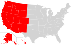
The Western United States (also called the American West, the Western States, the Far West, the Western territories, and the West) is one of the four census regionsdefined by the United States Census Bureau.
As American settlement in the U.S. expanded westward, the meaning of the term the West changed. Before around 1800, the crest of the Appalachian Mountains was seen as the western frontier. The frontier moved westward and eventually the lands west of the Mississippi River were considered the West.[5]
While the West is defined by many occupations, the American cowboy is often used as an icon of the region, here portrayed by C. M. Russell.The West, as the most recently settled part of the United States, is often known for broad highways and open space. Pictured is a road in Utah to Monument Valley on the Navajo Nation.
The Western United States is the largest region of the country, covering nearly half the land area of the contiguous United States. It is also the most geographically diverse, incorporating geographic regions such as the temperate rainforests of the Northwest, the highest mountain ranges, including the Rocky Mountains, the Sierra Nevada, and the Cascade Range, numerous glaciers, and the western edge of the Great Plains. It also contains the majority of the desert areas located in the United States. The Mojave and the Great Basin deserts lie entirely within the Western region, along with parts of the Sonoran and Chihuahuan deserts (the latter extends significantly into Texas, while both extend into Mexico). Given this expansive and diverse geography it is no wonder that the region is difficult to define precisely. Sensing a possible shift in the popular understanding of the West as a region in the early 1990s, historian Walter Nugent conducted a survey of three groups of professionals with ties to the region: a large group of Western historians (187 respondents), and two smaller groups, 25 journalists and publishers and 39 Western authors.[6] A majority of the historian respondents placed the eastern boundary of the West east of the Census definition out on the eastern edge of the Great Plains or on the Mississippi River. The survey respondents as a whole showed just how little agreement there was on the boundaries of the West.
Subregions
The region is split into two smaller units or divisions, by the U.S. Census Bureau:[1]
Other classifications distinguish between Southwest and Northwest. Arizona, New Mexico, West Texas, and the Oklahoma panhandle are typically considered to be the Southwest states. Meanwhile, the states of Montana, Idaho, Oregon, and Washington can be considered part of the Northwest or Pacific Northwest.
The term West Coast is commonly used to refer to just California, Oregon, Washington, and Alaska, whereas Hawaii is more geographically isolated from the continental U.S. and does not necessarily fit in any of these subregions.
As defined by the United States Census Bureau, the Western region of the United States includes 13 states,[1] with a total 2020 population of 78,588,572.[3]
The West is one of the most sparsely settled areas in the United States with 49.5 inhabitantsper square mile (19.1 inhabitants/km2). Only Texas with 78.0 inhabitants/mi2 (30.1 inhabitants/km2), Washington with 86.0 inhabitants/mi2 (33.2 inhabitants/km2), and California with 213.4 inhabitants/mi2 (82.4 inhabitants/km2) exceed the national average of 77.98 inhabitants/mi2 (30.11 inhabitants/km2). As of 2022, just under half of the 78.7 million residents of the West live in California.[19]
These maps from the 2000 US Census highlight differences from state to state of three minority groups. Most of the American Indian, Hispanic, and Asian population is in the West.
The entire Western region has also been strongly influenced by European, Hispanic or Latino, Asian and Native Americans; it contains the largest number of minorities in the U.S. While most of the studies of racial dynamics in America such as riots in Los Angeles have been written about European and African Americans, in many cities in the West and California, whites and blacks together are less than half the population because of the preference for the region by Hispanics and Asians. African and European Americans, however, continue to wield a stronger political influence because of the lower rates of citizenship and voting among Asians and Hispanics.
Beyond the deserts lie the Rocky Mountains. In the north, they run almost immediately east of the Cascade Range, so that the desert region is only a few miles wide by the time one reaches the Canada–US border. The Rockies are hundreds of miles wide and run uninterrupted from New Mexico to Alaska. The Rocky Mountain Region is the highest overall area of the United States, with an average elevation of above 4,000 feet (1,200m). The tallest peaks of the Rockies, 54 of which are over 14,000 feet (4,300m), are found in central and western Colorado. East of the Rocky Mountains is the Great Plains, the western portions (for example, the eastern half of Colorado) of which are generally considered to be part of the western United States.
The Colorado River is a major source of water in the Southwest and many dams, such as the Hoover Dam, form reservoirs along it. So much water is drawn for drinking water throughout the West and irrigation in California that in most years, water from the Colorado River no longer reaches the Gulf of California. The Columbia River, the largest river in volume flowing into the Pacific Ocean from North America, and its tributary, the Snake River, water the Pacific Northwest. The Platte runs through Nebraska and was known for being a mile (2km) wide but only a half-inch (1cm) deep. The Rio Grande forms the border between Texas and Mexico before turning due north and splitting New Mexico in half.
Most of the public land held by the U.S. National Forest Service and Bureau of Land Management is in the Western states. Public lands account for 25 to 75 percent of the total land area in these states.[27]
The climate of the West is semi-arid, yet parts of the region get high amounts of rain or snow. Other parts are true desert which receive less than 5 inches (130mm) of rain per year. The climate is increasingly unstable, and subject to periods of severe drought.[28]
The seasonal temperatures vary greatly throughout the West. Low elevations on the West Coast have warm summers and mild winters with little to no snow. The desert southwest has very hot summers and mild winters. While the mountains in the southwest receive generally large amounts of snow. The Inland Northwest has a continental climate of warm to hot summers and cold to bitterly cold winters.
Annual rainfall is greater in the eastern portions, gradually tapering off until reaching the Pacific Coast where it increases again. In fact, the greatest annual rainfall in the United States falls in the coastal regions of the Pacific Northwest. Drought is much more common in the West than the rest of the United States. The driest place recorded in the United States is Death Valley, California.[29] In Western states, drought is closely associated with fire risk, and there have been a number of notable wildfires causing extensive property damage and wildlife habitat destruction. The Western United States is predicted to experience drought-like conditions for much of the 21st century.[28]
Violent thunderstorms occur east of the Rockies. Tornadoes occur every spring on the southern plains, with the most common and most destructive centered on Tornado Alley, which covers eastern portions of the West, (Texas to North Dakota), and all states in between and to the east.
Agriculture varies depending on rainfall, irrigation, soil, elevation, and temperature extremes. The arid regions generally support only livestock grazing, chiefly beef cattle. The wheat belt extends from Texas through The Dakotas, producing most of the wheat and soybeans in the U.S. and exporting more to the rest of the world. Irrigation in the Southwest allows the growth of great quantities of fruits, nuts, and vegetables as well as grain, hay, and flowers. Texas is a major cattle and sheep raising area, as well as the nation's largest producer of cotton. Washington is famous for its apples, and Idaho for its potatoes. California and Arizona are major producers of citrus crops, however, declining supplies of water, as well as urban sprawl have contributed to a sharp decline in citrus production in Arizona.[30] Many varieties of chile peppers are grown in the valleys of New Mexico.[31][32]
Starting in 1902, Congress passed a series of acts authorizing the establishment of the United States Bureau of Reclamation to oversee water development projects in seventeen western states.
During the first half of the 20th century, dams and irrigation projects provided water for rapid agricultural growth throughout the West and brought prosperity for several states, where agriculture had previously only been subsistence level. Following World War II, the West's cities experienced an economic and population boom. The population growth, mostly in the Southwest states of New Mexico, Utah, Colorado, Arizona, and Nevada, has strained water and power resources, with water diverted from agricultural uses to major population centers, such as the Las Vegas Valley and Los Angeles.
Geology
Plains make up much of the eastern portion of the West, underlain with sedimentary rock from the Upper Paleozoic, Mesozoic, and Cenozoic eras. The Rocky Mountains expose igneous and metamorphic rock both from the Precambrian and from the Phanerozoic eon. The Inter-mountain States and Pacific Northwest have huge expanses of volcanic rock from the Cenozoic era. Salt flats and salt lakes reveal a time when the great inland seas covered much of what is now the West.
The Pacific states are the most geologically active areas in the United States. Earthquakes cause damage every few to several years in California. While the Pacific states are the most volcanically active areas, extinct volcanoes and lava flows are found throughout most of the West.
Along the southwestern border there are jaguars and ocelots. Other mammals include the Virginia opossum, which occurs throughout California and coastal areas in Oregon and Washington. The North American beaver and mountain beaver live in forested areas of Washington, Oregon and Northern California. The kit fox lives throughout Arizona, New Mexico and Utah, while the gray fox occurs throughout the Western U.S.
The Western United States has been populated by Native Americans since at least 11,000 years ago, when the first Paleo-Indians arrived. Pre-Columbian trade routes to kingdoms and empires such as the Mound Builders existed in places such as Yellowstone National Park since around 1000 AD. Major settlement of the western territories developed rapidly in the 1840s, largely through the Oregon Trail and the California Gold Rush of 1849. California experienced such a rapid growth in a few short months that it was admitted to statehood in 1850 without the normal transitory phase of becoming an official territory.[34]
Map of Western Territories, circa 1847–1861.
One of the largest migrations in American history occurred in the 1840s as the Latter Day Saints left the Midwest to build a theocracy in Utah.
Between 1863 and 1869, North America's first transcontinental railroad was constructed to connect the eastern US with the Pacific coast. The resulting railroad connection revolutionized the settlement and economy of the American West by making the transportation of passengers and freight quicker, safer, and cheaper.
The history of the American West in the late 19th and early 20th centuries has acquired a cultural mythos in the literature and cinema of the United States. The image of the cowboy, the homesteader, and westward expansion took real events and transmuted them into a myth of the west which has shaped much of American popular culture since the late 19th century.[36]
Writers as diverse as Bret Harte and Zane Grey celebrated or derided cowboy culture, while artists such as Frederic Remington created Western art as a method of recording the expansion into the west. The American cinema, in particular, created the genre of the Western movie, which, in many cases, use the West as a metaphor for the virtue of self-reliance and an American ethos. The contrast between the romanticism of culture about the West and the actuality of the history of the westward expansion has been a theme of late 20th and early 21st century scholarship about the West. Cowboy culture has become embedded in the American experience as a common cultural touchstone, and modern forms as diverse as country and western music have celebrated the sense of isolation and independence of spirit inspired by the frontiersmen on "virgin land".[37]
20th century
Western United States in 1908 from The Harmsworth atlas and GazetterU.S. Route 66 accelerated the development of the Western United States.
The advent of the automobile enabled the average American to tour the West. Western businessmen promoted Route 66 as a means to bring tourism and industry to the West. In the 1950s, representatives from all the western states built the Cowboy Hall of Fame and Western Heritage Center to showcase western culture and greet travelers from the East. During the latter half of the 20th century, several transcontinental interstate highways crossed the West bringing more trade and tourists from the East. Oil boom towns in Texas and Oklahoma rivaled the old mining camps for their rawness and wealth. The Dust Bowl forced children of the original homesteaders even further west.[38]
Since the mid-1970s, historians of the West have emphasized the World War II years as a major watershed, as a region experienced enormous social and economic change, and became the pacesetter for societal evolution. The population soared, especially in metropolitan areas, as a result of massive expansion of the manufacture of airplanes, ships and munitions and of military and Naval training facilities. California upgraded universities to world-class status, intensified scientific research, and expanded infrastructure. After the war millions more migrated using the GI Bill to buy suburban homes, many of them recalling rewarding wartime experience in military training facilities. The region had always been more democratic with greater racial and gender equality, and continued as a national pacesetter in modernization. New problems emerged, especially environmental issues where westerners took the lead in areas such as the allocation of scarce water resources as well as dealing with smog and air pollution. More recently historians have looked at nuances, pointing out that some of the trends began before 1941.[42]
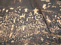
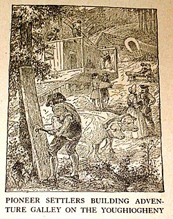
Newspaper Rock State Historic Monument, Utah, contains petroglyphs left by the first inhabitants of the American Southwest.The pioneers were among the earliest European Americans to settle in the western frontier.
Facing both the Pacific Ocean and the Mexican border, the West has been shaped by a variety of ethnic groups. Hawaii is the only state in the union in which Asian Americans outnumber white American residents. People from many countries in Asia settled in California and other coastal states in several waves of immigration since the 19th century, contributing to the Gold rush, the building of the transcontinental railroad, agriculture, and more recently, high technology.
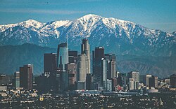
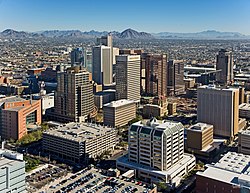
In the Pacific States, the wide areas filled with small towns, farms, and forests are supplemented by a few big port cities which have evolved into world centers for the media and technology industries. Now the second largest city in the nation, Los Angeles is best known as the home of the Hollywoodfilm industry; the area around Los Angeles also was a major center for the aerospace industry by World War II, though Boeing, located in Washington state would lead the aerospace industry. Fueled by the growth of Los Angeles, as well as the San Francisco Bay area, including Silicon Valley, the center of America's high tech industry, California has become the most populous of all the 50 states. Oregon and Washington have also seen rapid growth with the rise of Boeing and Microsoft along with agriculture and resource based industries.
Alaska—the northernmost state in the Union—is a vast land of few people, many of them native, and of great stretches of wilderness, protected in national parks and wildlife refuges. Hawaii's location makes it a major gateway between the United States and Asia, as well as a center for tourism.
The Mountain States subregion includes Arizona, Colorado, Idaho, Montana, Nevada, New Mexico, Utah, and Wyoming. The mountain states have relatively low population densities, and developed as ranching and mining areas that only recently became urbanized. Most of them have highly individualistic cultures, and have worked to balance the interests of urban development, recreation, and the environment.
These are the largest Metropolitan Statistical Areas (MSA) with a population above 500,000 in the 13 Western states. Population figures are as of April 1, 2020, as enumerated by the United States Census Bureau:[46]
The MSA of El Paso, although belonging to Texas, considered part of the Southern United States, it is sometimes also considered part of the Western United States. Its enumerated population in April 2020 was 868,859.[46]
The largest MSA in Alaska is Anchorage; it has an enumerated population of 398,328, as of April 2020.[46]
Alaska and most Mountain states are more Republican, with Alaska, Idaho, Montana, Utah, and Wyoming being Republican strongholds. The state of Arizona has been won by the Republican presidential candidate in every election except three times since 1948, but in 2020 Arizona voted Democratic. Also, in 2018 and 2020, the GOP lost both U.S. Senate seats in Arizona to the Democrats. The states of Idaho, Utah, and Wyoming have been won by every Republican presidential nominee since 1964.
The state of Nevada is considered a political bellwether, having correctly voted for every president except twice (in 1976 and 2016) since 1912. New Mexico too is considered a bellwether, having voted for the popular vote winner in every presidential election since statehood, except in 1976 and 2024.
As the fastest-growing demographic group, after Asians, Latinos are hotly contested by both parties. Immigration is an important political issue for this group. Backlash against undocumented immigrants led to the passage of California Proposition 187 in 1994, a ballot initiative which would have denied many public services to them. Association of this proposal with California Republicans, especially incumbent governor Pete Wilson, drove many Hispanic voters to the Democrats.[49]
The following table shows the breakdown of party affiliation of governors, attorneys general, state legislative houses, and U.S. congressional delegation for the Western states, as of 2019[update].
The following table shows the breakdown of party affiliation of governors, attorneys general, state legislative houses, and U.S. congressional delegation for the outlying areas of the Western United States, as of 2020[update].[50][51][52]
The Western United States consistently ranks well in health measures. The rate of potentially preventable hospitalizations in the Western United States was consistently lower than other regions from 2005 to 2011.[53] While the proportion of maternal or neonatal hospital stays was higher in the Western United States relative to other regions, the proportion of medical stays in hospitals was lower than in other regions in 2012.[54]
↑Wiess, AJ and Elixhauser A (October 2014). "Overview of Hospital Utilization, 2012". HCUP Statistical Brief No. 180. Rockville, MD: Agency for Healthcare Research and Quality.
Deutsch, Sarah. Making a Modern U.S. West: The Contested Terrain of a Region and Its Borders 1898–1940. Lincoln: University of Nebraska Press, 2022.
Doig, Ivan. This House of Sky: Landscapes of a Western Mind. New York. 1978.
Findlay, John M. The Mobilized American West, 1940–2000. Lincoln, NE: University of Nebraska Press, 2023. Comprehensive history online review of this book
Malone, Michael P., and Richard W. Etulain. The American West: A Twentieth-Century History. Lincoln: University of Nebraska Press, 1989.
Milner II, Clyde A; O'Connor, Carol A.; Sandweiss, Martha A. The Oxford History of the American West. Oxford University Press, 1994.
Morgan, Neil Bowen. Westward Tilt: The American West Today. New York: Random House, 1963.
Pomeroy, Earl. The American Far West in the Twentieth Century. New Haven, CT: Yale University Press, 2009. ISBN0300158521
Schwantes, Carlos Arnaldo. Going Places: Transportation Redefines the Twentieth-Century West. Bloomington: Indiana University Press, 2003.
Stegner, Wallace. The Sound of Mountain Water: The Changing American West. Garden City, NY: Doubleday, 1969.
White, Richard. A New History of the American West: 'It's Your Misfortune and None of My Own.' Norman: University of Oklahoma Press, 1991.
Whitehead, John. Completing the Union: Alaska, Hawai'i, and the Battle for Statehood. Albuquerque: University of New Mexico Press, 2004
Wiley, Peter, and Robert Gottlieb. Empires in the Sun: The Rise of the New American West. New York. 1982.
Graham, Don. Kings of Texas: The 150-Year Saga of an American Ranching Empire. Hoboken, NJ: John Wiley and Sons, 2003.
Nash, Gerald D. A.P. Giannini and the Bank of America. Norman: University of Oklahoma Press, 1992.
Nash, Gerald D. The Federal Landscape: An Economic History of the Twentieth-Century West. Tucson: University of Arizona Press. 1999.
O'Mara, Margaret. The Code: Silicon Valley and the Remaking of America. New York: Penguin Press, 2019.
Robbins, William G. Colony and Empire: The Capitalist Transformation of the American West. Lawrence: University Press of Kansas, 1994.
Environment
Abbey, Edward. Desert Solitaire: A Season in the Wilderness. New York: McGraw-Hill, 1968.
Castaneda, Christopher J., and Lee M. A. Simpson, eds. River City and Valley Life: An Environmental History of the Sacramento region. Pittsburgh, PA: University of Pittsburgh Press, 2013. In California; online
Cawley, R. McGreggor. Federal Land, Western Anger: The Sagebrush Rebellion and Environmental Politics. Lawrence: University Press of Kansas, 1993. On conservatives.
Cunfer, Geoff, and Bill Waiser, eds. Bison and People on the North American Great Plains: A Deep Environmental History. College Station, TX: Texas A&M University Press, 2016. online.
Dant, Sara. Losing Eden: An Environmental History of the American West. Lincoln, NE: University of Nebraska Press, 2023. online, also see online book review
DeBuys, William. Enchantment and Exploitation: The Life and Hard Times of a New Mexico Mountain Range. Albuquerque: University of New Mexico Press, 1985.
DeVoto, Bernard. "The West: A Plundered Province." Harper's Magazine 169 (1934): 355–364.
Dobie, J. Frank. The Longhorns. Boston: Little, Brown, 1941.
Dobie, J. Frank. The Mustangs. Boston: Little, Brown, 1952.
Dobie. J. Frank. The Voice of the Coyote. Boston: Little, Brown, 1949.
Flores, Dan. The Natural West: Environmental History in the Great Plains and Rocky Mountains. Norman, OK: University of Oklahoma Press, 2003. online.
Fradkin, Philip. A River No More: The Colorado River and the West, 2nd ed. Berkeley: University of California Press, 1996.
Frehner, Brian, and Kathleen A. Brosnan, eds. The Greater Plains: Rethinking a Region's Environmental Histories. Lincoln, NE: University of Nebraska Press, 2021. online.
Harvey, Mark W. T. "Echo Park, Glen Canyon, and the Postwar Wilderness Movement." Pacific Historical Review (1991): 43–67. online Colorado River region
Hollon, W. Eugene. The Great American Desert, Then and Now. Lincoln: University of Nebraska Press, 1975.
Huggard, Christopher, and Arthur R. Gómez. Forests under Fire: A Century of Ecosystem Mismanagement in the Southwest. Tucson: University of Arizona Press, 2001.
Hundley Jr., Norris. Water and the West: The Colorado River Compact and the Politics of Water in the American West. 2nd ed. University of California Press, 2009.
Krutch, Joseph Wood. The Voice of the Desert: A Naturalist's Interpretation. New York: William Sloane Associates, 1954.
Lamm, Richard D., and Michael McCarthy. The Angry West: A Vulnerable Land and Its Future. Boston, MA: Houghton Mifflin Harcourt, 1982.
Logan, Michael F. Desert Cities: The Environmental History of Phoenix and Tucson. Pittsburgh, PA; University of Pittsburgh Press, 2006.
Needham, Andrew. Power Lines: Phoenix and the Making of the Modern Southwest. Princeton, NJ: University of Princeton Press, 2014.
Pisani, Donald J. Water, Land, and Law in the West: The Limits of Public Policy, 1850-1920. Lawrence: University Press of Kansas, 1996.
Pyne, Stephen J. Fire: A Brief History. Seattle: University of Washington Press, 2001.
Pyne, Stephen J. Fire on the Rim: A Firefighter's Season at the Grand Canyon. New York: Grove Press, 1989.
Rowley, William D. Reclaiming the Arid West: The Career of Francis G. Newlands. Bloomington: Indiana University Press, 1996.
Rundell Jr., Walter. Oil in West Texas and New Mexico: A Pictorial History of the Permian Basin. College Station: Texas A & M University Press, 1982.
Stegner, Wallace. The American West As Living Space. Ann Arbor: University of Michigan Press, 1987.
Sturgeon, Stephen Craig. The Politics of Western Water: The Congressional Career of Wayne Aspinall. Tucson, AZ: University of Arizona Press, 2002.
Vogel, David. California Greenin': How the Golden State became an Environmental Leader Princeton, NJ: Princeton University Press, 2019).
White, Richard. The Organic Machine: The Remaking of the Columbia River. New York: Hill and Wang, 1995.
Wild, Peter. Pioneer Conservationists of Western America (1979) online
Worster, Donald. Under Western Skies: Nature and History in the American West Oxford University Press, 1992. online
Worster, Donald. Dust Bowl: The Southern Plains in the 1930s. New York: Oxford University Press, 1979.
Worster, Donald. Rivers of Empire: Water, Aridity, and the Growth of the American West. New York: Pantheon Books, 1987.
Historiography
Billington, Ray Allen. America's Frontier Heritage. Albuquerque, University of New Mexico Press, 1984.
Etulain, Richard W., "Clio's Disciples on the Rio Grande: Western History at the University of New Mexico", New Mexico Historical Review 87 (Summer 2012): 277–298.
Etulain, Richard W. Telling Western Stories: From Buffalo Bill to Larry McMurtry. Albuquerque: University of New Mexico Press, 1999.
Etulain, Richard W. The American West and Its Interpreters. Albuquerque: University of New Mexico Press, 2023.
Etulain, Richard W. Writing Western History: Essays On Major Western Historians Reno, NV: University of Nevada Press, 2002.
Faragher, John Mack, ed. Rereading Frederick Jackson Turner: The Significance of the Frontier in American History and Other Essays. New York: Holt, 1994.
Frantz, Joe B. Aspects of the American West: Three Essays. College Station: Texas A&M University Press, 1976.
Gressley, Gene. "Whither Western American History? Speculations on a Direction," Pacific Historical Review 53, no. 4 (1984): 483–501.
Malone, Michael P. "Beyond the Last Frontier: Toward a New Approach to Western American History." The Western Historical Quarterly 20, no. 4 (1989): 409–27.
Malone, Michael P., ed. Historians and the American West. Lincoln: University of Nebraska Press, 1983.
Nash, Gerald D. Creating the West: Historical Interpretations, 1890–1990. Albuquerque: University of New Mexico Press, 1991.
Nash, Gerald D., and Richard W. Etulain. The Twentieth-Century West: Historical Interpretations. Albuquerque: University of New Mexico Press, 1989.
Norris Jr., Hundley, and John A. Schutz, ed. The American West: Frontier and Region--Interpretations by John Walton Caughey. Los Angeles, CA: Ward Ritchie Press, 1969.
Pomeroy, Earl. "Toward a Reorientation of Western History: Continuity and Environment." The Mississippi Valley Historical Review 41, no. 4 (1955): 579–600.
Prince, Gregory A. Leonard Arrington and the Writing of Mormon History. Salt Lake City: University of Utah Press, 2016.
Rensink, Brenden W., ed. The North American West in the Twenty-First Century. Lincoln: University of Nebraska Press, 2022.
Ridge, Martin. "The Life of an Idea: The Significance of Frederick Jackson Turner’s Frontier Thesis." Montana: The Magazine of Western History 41, no. 1 (1991): 2–13.
Sonnichsen, C. L. The Ambidextrous Historian: Historical Writers and Writing in the American West. Norman: University of Oklahoma Press, 1981.
Stegner, Wallace and Richard W. Etulain. Stegner: Conversations on History and Literature. Salt Lake City: University of Utah Press, 1983.
Labor
Andrews, Thomas G. Killing for Coal: America’s Deadliest Labor War. Cambridge, MA: Harvard University Press, 2008.
Brykit, James W. Forging the Copper Collar: Arizona's Labor-Management War of 1901-1921. Tucson, University of Arizona Press, 1982.
Lukas, J. Anthony. Big Trouble: A Murder in a Small Western Town Sets Off a Struggle for the Soul of America. New York: Simon and Schuster, 1997.
Schwantes, Carlos Arnaldo. Radical Heritage: Labor, Socialism, and Reform in Washington and British Columbia, 1885-1917. Seattle: University of Washington Press, 1979.
Military history
Amundson, Michael A. Yellowcake Towns: Uranium Mining Communities in the American West. Boulder: University Press of Colorado, 2002.
Bolton, Roger E. Defense Purchases and Regional Growth. Washington, D.C. 1966.
Brilliant, Mark and David M. Kennedy, eds. World War II and the West It Wrought. Redwood City, CA: Stanford University Press. 2020. excerpt
Clayton, James L. "Impact of the Cold War on the Economies of California and Utah." Pacific Historical Review, 36 (1967): 449–473.
Fernlund, Kevin J., ed. The Cold War American West, 1945–1989. Albuquerque: University of New Mexico Press, 1998.
Findlay, John M. and Hevley, Bruce W. Atomic Frontier Days: Hanford and the American West. Center for the Study of the Pacific Northwest in Association with Seattle: University of Washington Press, 2011.
Heefner, Gretchen. The Missile Next Door: The Minuteman in the American Heartland. Cambridge, MA: Harvard University Press, 2012.
Hevly, Bruce W. and John M. Findlay, ed. The Atomic West. Seattle: University of Washington Press, 1998.
Hull, McAllister, with Amy Bianco. Rider of the Pale Horse: A Memoir of Los Alamos and Beyond. Albuquerque: University of New Mexico Press, 2005.
Hunner, Jon. J. Robert Oppenheimer, the Cold War, and the Atomic West. Norman: University of Oklahoma Press, 2009.
Larson, T.A. Wyoming's War Years, 1941–1945. Laramie: University of Wyoming, 1954.
Lotchin, Roger. Japanese American Relocation in World War II: A Reconsideration. Cambridge, UK: Cambridge University Press, 2018.
Lotchin, Roger W. "The Metropolitan-Military Complex in Comparative Perspective: San Francisco, Los Angeles, and San Diego, 1919–1941." Journal of the West, 20 (July 1979): 19–30.
Martini, Edwin A. Proving Grounds: Militarized Landscapes, Weapons Testing, and the Environmental Impact of U.S. Bases. Seattle: University of Washington Press, 2015.
Nash, Gerald D. The American West Transformed: The Impact of the Second World War. Bloomington: Indiana University Press, 1985.
Nash, Gerald D. World War II and the West: Reshaping the Economy. Lincoln: University of Nebraska Press. 1990.
Rosier, Paul C. "'They Are Ancestral Homelands': Race, Place, and Politics in Cold War Native America, 1945-1961." The Journal of American History 92, no. 4 (2006): 1300–26.
Szasz, Ferenc Morton. The Day the Sun Rose Twice: The Story of the Trinity Site Nuclear Explosion, July 16, 1945. Albuquerque: University of New Mexico Press, 1984.
Mythic West
Athearn, Robert G.The Mythic West in Twentieth-Century America. Lawrence: University Press of Kansas, 1986.
Etulain, Richard W. Re-Imagining the Modern American West: A Century of Fiction, History, and Art. Tucson: University of Arizona Press. 1996.
Gibson, Arrell M. The Santa Fe and Taos Colonies: Age of the Muses, 1900–1942. Norman: University of New Mexico Press, 1988.
Lehan, Richard. Quest West: American Intellectual and Cultural Transformations. Baton Rouge: Louisiana State University Press, 2014.
Savage Jr., William W. The Cowboy Hero: His Image in American History and Culture. Norman: University of Oklahoma Press, 1979.
Native Americans
Brown, Dee. Bury My Heart at Wounded Knee: An Indian History of the American West. New York: Holt, Rinehart and Winston, 1970.
Debo, Angie. And Still the Waters Run: The Betrayal of the Five Civilized Tribes. Princeton, NJ: University of Princeton Press, 1968.
Deloria Jr. Vine, and Clifford M. Lytle. American Indians, American Justice. Austin: University of Texas Press, 1983.
Fixico, Donald L. Termination and Relocation: Federal Indian Policy, 1945–1960. Albuquerque: University of New Mexico Press, 1986.
Iverson, Peter. When Indians Became Cowboys: Native Peoples and Cattle Ranching in the American West. Norman: University of Oklahoma Press, 1994.
Parman, Donald Lee. Indians and the American West in the Twentieth Century. Bloomington: Indiana University Press, 1994.
Politics
Danbom, David B. Bridging the Distance: Common Issues of the Rural West. Salt Lake City: University of Utah Press, 2015.
Fernlund, Kevin J. Lyndon B. Johnson and Modern America. Norman: University of Oklahoma Press, 2009.
Iverson, Peter. Barry Goldwater: Native Arizonan. Norman: University of Oklahoma Press, 1997.
Lowitt, Richard. The New Deal and the West. Bloomington: Indiana University Press, 1984 online
Rothman, Hal K. LBJ's Texas White House: 'Our Heart's Home.' College Station: Texas A&M University Press, 2001.
Smith, Thomas G. Stewart L. Udall: Steward of the Land. Albuquerque: University of New Mexico Press, 2017.
Stratton, David H. Tempest Over Teapot Dome: The Story of Albert B. Fall. Norman: University of Oklahoma Press, 1998.
Young, Nancy Beck. Two Suns of the Southwest: Lyndon Johnson, Barry Goldwater, and the 1964 Battle between Liberalism and Conservatism. Lawrence: University Press of Kansas, 2019.
Barber, Alicia. Reno’s Big Gamble: Image and Reputation in the Biggest Little City. Lawrence: University Press of Kansas. 2008.
Cottam, Erica. Hubbell Trading Post: Trade, Tourism, and the Navajo Southwest. Norman: University of Oklahoma Press, 2015.
McCormack, Kara L. Imagining Tombstone: The Town Too Tough to Die. Lawrence, University Press of Kansas, 2016.
Pomeroy, Earl. In Search of the Golden West: The Tourist in Western America. New York: Knopf, 1957.
Rothman, Hal K. Devil's Bargains: Tourism and the Twentieth-Century American West. Lawrence: University of Kansas Press, 1998.
Rugh, Susan Sessions. "Branding Utah: Industrial Tourism in the Postwar American West." Western Historical Quarterly 37, no. 4 (2006): 445–472.
Stratton, David H. Tucumcari Tonite!: A Story of Railroads, Route 66, and the Waning of a Western Town. Albuquerque: University of New Mexico Press, 2022.
Wrobel, David. Promised Lands: Promotion, Memory, and the Creation of the American West. Lawrence: University Press of Kansas, 2002.
Urban West
Abbott, Carl (2008). How Cities Won the West: Four Centuries of Urban Change in Western North America. Albuquerque: University of New Mexico Press. ISBN978-0-8263-3312-4.
Davis, Mike. City of Quartz: Excavating the Future of Los Angeles. New York: Verso, 1990.
Findlay, John M. Magic Lands: Western Cityscapes and American Culture After 1940. Berkeley: University of California Press, 1992.
Gómez, Arthur R. Quest for the Golden Circle: The Four Corners and the Metropolitan West, 1945-1970. Albuquerque: University of New Mexico, 1994.
Leonard, Stephen J., and Thomas J. Noel. Denver: Mining Camp to Metropolis. Boulder: University Press of Colorado, 1990.
Luckingham, Bradford. The Urban Southwest: A Profile History of Albuquerque, El Paso, Phoenix, and Tucson. El Paso: Texas Western Press, 1982.
Nash, Gerald D. The American West in the Twentieth Century – A Short History of an Urban Oasis. Hoboken, NJ: Prentice Hall, 1973.
Rothman, Hal. Neon Metropolis: How Las Vegas Started the Twenty-First Century. Oxfordshire, UK: Routledge, 2003.
Sonnichsen, C.L. Tucson: The Life and Times of an American City. Norman: University of Oklahoma Press, 1982.
Stratten, David H., ed. Spokane and the Inland Empire: An Interior Pacific Northwest Anthology. Rev. ed. Pullman: Washington State University Press, 2007.
Wilson, Chris. The Myth of Santa Fe: Creating a Modern Regional Tradition. Albuquerque: University of New Mexico Press, 1997.
This page is based on this Wikipedia article Text is available under the CC BY-SA 4.0 license; additional terms may apply. Images, videos and audio are available under their respective licenses.


![State laws regarding Medical Aid in Dying in the United States
.mw-parser-output .legend{page-break-inside:avoid;break-inside:avoid-column}.mw-parser-output .legend-color{display:inline-block;min-width:1.25em;height:1.25em;line-height:1.25;margin:1px 0;text-align:center;border:1px solid black;background-color:transparent;color:black}.mw-parser-output .legend-text{}
Assisted dying is legal
Pending legislation to legalize assisted dying
.mw-parser-output .navbar{display:inline;font-size:88%;font-weight:normal}.mw-parser-output .navbar-collapse{float:left;text-align:left}.mw-parser-output .navbar-boxtext{word-spacing:0}.mw-parser-output .navbar ul{display:inline-block;white-space:nowrap;line-height:inherit}.mw-parser-output .navbar-brackets::before{margin-right:-0.125em;content:"[ "}.mw-parser-output .navbar-brackets::after{margin-left:-0.125em;content:" ]"}.mw-parser-output .navbar li{word-spacing:-0.125em}.mw-parser-output .navbar a>span,.mw-parser-output .navbar a>abbr{text-decoration:inherit}.mw-parser-output .navbar-mini abbr{font-variant:small-caps;border-bottom:none;text-decoration:none;cursor:inherit}.mw-parser-output .navbar-ct-full{font-size:114%;margin:0 7em}.mw-parser-output .navbar-ct-mini{font-size:114%;margin:0 4em}html.skin-theme-clientpref-night .mw-parser-output .navbar li a abbr{color:var(--color-base)!important}@media(prefers-color-scheme:dark){html.skin-theme-clientpref-os .mw-parser-output .navbar li a abbr{color:var(--color-base)!important}}@media print{.mw-parser-output .navbar{display:none!important}}
v
t
e USA States where Medical Aid in Dying is legal.svg](http://upload.wikimedia.org/wikipedia/commons/thumb/d/d9/USA_States_where_Medical_Aid_in_Dying_is_legal.svg/250px-USA_States_where_Medical_Aid_in_Dying_is_legal.svg.png)
