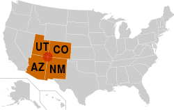
Four Corners

Last updated

The Four Corners region is the red circle in this map. The Four Corners states are highlighted in orange. Four Corners.svg
The Four Corners region is the red circle in this map. The Four Corners states are highlighted in orange.
False-color satellite image of the Four Corners. Bright red lines are vegetation along the major rivers of the area. Four Corners, Southwestern U.S.jpg
False-color satellite image of the Four Corners. Bright red lines are vegetation along the major rivers of the area.
A young Navajo boy on horseback in Monument Valley. The Navajo Nation includes much of the Four Corners area, including the valley, used in many western movies. Navajo (young boy) 2007.jpg
A young Navajo boy on horseback in Monument Valley. The Navajo Nation includes much of the Four Corners area, including the valley, used in many western movies.
Flags surrounding the Four Corners Monument. In clockwise order starting from the frontmost flag, the state flag of Arizona, Flag of the Navajo Nation (twice), Utah, Ute Mountain Ute Tribe Reservation, Colorado, New Mexico, Navajo Nation (third instance), and the flag of the United States Four Corners Monument (1).jpg
Flags surrounding the Four Corners Monument. In clockwise order starting from the frontmost flag, the state flag of Arizona, Flag of the Navajo Nation (twice), Utah, Ute Mountain Ute Tribe Reservation, Colorado, New Mexico, Navajo Nation (third instance), and the flag of the United States
The Durango and Silverton Narrow Gauge Railroad, now a heritage railway, formerly connected the Four Corners area to the national rail network. DurangoSilverton1.jpg
The Durango and Silverton Narrow Gauge Railroad, now a heritage railway, formerly connected the Four Corners area to the national rail network.
Bluff, Utah and Comb Ridge from the air Bluff UT - aerial with San Juan River and Comb Ridge.jpg
Bluff, Utah and Comb Ridge from the air

The Four Corners is a region of the Southwestern United States consisting of the southwestern corner of Colorado, southeastern corner of Utah, northeastern corner of Arizona, and northwestern corner of New Mexico. Most of the Four Corners region belongs to semi-autonomous Native American nations, the largest of which is the Navajo Nation, followed by Hopi, Ute, and Zuni tribal reserves and nations. The Four Corners region is part of a larger region known as the Colorado Plateau and is mostly rural, rugged, and arid.

Contents

The Four Corners area is named after the quadripoint at the intersection of approximately 37° north latitude with 109° 03′ west longitude, where the boundaries of the four states meet, and are marked by the Four Corners Monument. It is the only location in the United States where four states meet. In addition to the monument, commonly visited areas within Four Corners include Monument Valley, Mesa Verde National Park, Chaco Canyon, Canyons of the Ancients National Monument and Canyon de Chelly National Monument. The most populous city in the Four Corners region is Farmington, New Mexico, followed by Durango, Colorado.

History

The United States acquired the four corners region from Mexico after the end of the Mexican–American War in 1848. In 1863 Congress created the Arizona Territory from the western part of New Mexico Territory. The boundary was legally defined as a line running due south from the southwest corner of Colorado Territory, which had been created in 1861. This was an unusual act of Congress, which almost always defined the boundaries of new territories as lines of latitude or longitude, or following rivers, but seldom as extensions of other boundaries.

By defining one boundary as starting at the corner of another, Congress ensured the eventual creation of four states meeting at a point, regardless of the inevitable errors of boundary surveying. [1] Due to a "standard" survey error of the time, the originally surveyed location of the "Four Corners" point was unintentionally located by its initial surveyor as being 1,821 feet (555 m) east of the original location actually specified by the US Congress in 1863. The area was first surveyed by the U.S. Government in 1868 as part of an effort to make Colorado Territory into a state, the first of the Four Corners states formed.

The first marker was placed at the originally surveyed and current spot in 1868. [2] In 1925, some 57 years after Congress had first attempted to specify the spot, the problems surrounding the originally misplaced marker were brought up before the US Supreme Court. In order to amicably remedy this original surveying error, the US Supreme Court then redefined the point of the Four Corners, officially moving the Four Corners point roughly 1,800 feet (550 m) east, to where the original survey had first held it to be all along, and to where it remains to this day, duly marked. [3] This initial survey error has resulted in some longstanding misunderstandings about the correct location of the Four Corners marker, some of which remain to this day. [4] The first Navajo tribal government was established in 1923 to regulate an increasing number of oil exploration activities on Navajo land. [5]

Geography

The Four Corners Monument is located at 36°59′56.3″N109°02′42.6″W / 36.998972°N 109.045167°W / 36.998972; -109.045167 . [6]

The Four Corners is part of the high Colorado Plateau. This makes it a center for weather systems, which stabilize on the plateau then proceed eastward through Colorado and into the central states. This weather system creates snow- and rainfall over the central United States. [7]

Federally protected areas in the Four Corners area include Canyon de Chelly National Monument, Hovenweep National Monument, Mesa Verde National Park, and Canyons of the Ancients National Monument. Mountain Ranges in the Four Corners include Sleeping Ute Mountains, Abajo Mountains, and the Chuska Mountains. [8]

Politics

Six governments have jurisdictional boundaries at the Four Corners Monument: the states of Arizona, Colorado, New Mexico, and Utah, as well as the tribal governments of the Navajo Nation and Ute Mountain Ute Tribe. [9] The Four Corners Monument itself is administered by the Navajo Nation Department of Parks and Recreation. [2] Other tribal nations within the Four Corners region include the Hopi and other Ute. [10] The Four Corners is home to the capital of the Navajo tribal government at Window Rock, Arizona. [5] The Ute Mountain Ute tribal headquarters are located at Towaoc, Colorado. [11] The US federal government also has a large presence in the area, particularly the Department of the Interior with the Bureau of Indian Affairs and the Department of Agriculture with the Forest Service.

Cities

The Four Corners region is mostly rural. The economic hub, largest city, and only metropolitan area in the region is Farmington, New Mexico. [12] The populated settlement closest to the center of Four Corners is Teec Nos Pos, Arizona. [13] Other cities in the region include Cortez and Durango in Colorado; Monticello and Blanding in Utah; Kayenta and Chinle in Arizona; and Shiprock, Aztec, and Bloomfield in New Mexico. [12]

Transportation

Air service is available via the Durango-La Plata County Airport in Durango, Colorado, Four Corners Regional Airport in Farmington, New Mexico, and Cortez Municipal Airport in Cortez, Colorado. Interstate 40 passes along the southern edge of the Four Corners region. The primary U.S. Highways that directly serve the Four Corners include U.S. Route 64, U.S. Route 160 (which serves the Four Corners Monument itself), U.S. Route 163, U.S. Route 191, U.S. Route 491 (previously U.S. Route 666 [14] ), and U.S. Route 550.

The main line of the Atchison, Topeka and Santa Fe Railway, now operated by the BNSF Railway, passes along the southern edge of Four Corners. The area is home to remnants of through railroads that are now heritage railways. These include the Durango and Silverton Narrow Gauge Railroad and the Cumbres and Toltec Scenic Railroad. The Black Mesa and Lake Powell Railroad, which connects a power plant with a coal mine near Kayenta, comes near the Four Corners. [8]

Helium

The Four Corners region was one of the first locations in the United States in which helium was extracted, and the area is increasingly important as a source of helium supply, with the region being noted for its abundance of high-grade 'green' helium. [15]

The most notable helium field in the region is Arizona's Holbrook basin.

See also

Related Research Articles

<span class="mw-page-title-main">Four Corners Monument</span> National monument in the Southwestern United States

The Four Corners Monument marks the quadripoint in the Southwestern United States where the states of Arizona, Colorado, New Mexico, and Utah meet. It is the only point in the United States shared by four states, leading to the area being named the Four Corners region. The monument also marks the boundary between two semi-autonomous Native American governments, the Navajo Nation, which maintains the monument as a tourist attraction, and the Ute Mountain Ute Tribe Reservation.

<span class="mw-page-title-main">San Juan County, Utah</span> County in Utah, United States

San Juan County is a county in the southeastern portion of the U.S. state of Utah. As of the 2020 United States Census, the population was 14,518. Its county seat is Monticello, while its most populous city is Blanding. The Utah State Legislature named the county for the San Juan River, itself named by Spanish explorers.

<span class="mw-page-title-main">San Juan County, New Mexico</span> County in New Mexico, United States

San Juan County is located in the U.S. state of New Mexico. As of the 2020 census, the population was 121,661 making it the fifth-most populous county in New Mexico. Its county seat is Aztec. The county was created in 1887.

<span class="mw-page-title-main">Montezuma County, Colorado</span> County in Colorado, United States

Montezuma County is a county located in the southwest corner of the U.S. state of Colorado. As of the 2020 census, the population was 25,849. The county seat is Cortez.

<span class="mw-page-title-main">Cortez, Colorado</span> City in Colorado, United States

Cortez is a home rule municipality that is the county seat and the most populous municipality of Montezuma County, Colorado, United States. The city population was 8,766 at the 2020 United States Census.

<span class="mw-page-title-main">Farmington, New Mexico</span> City in New Mexico, United States

Farmington is a city in San Juan County in the U.S. state of New Mexico. As of the 2020 census, the city had a population of 46,624 people. Farmington makes up one of the four metropolitan statistical areas (MSAs) in New Mexico.

<span class="mw-page-title-main">Navajo Nation</span> Federally recognized tribe within the Southwest United States

The Navajo Nation, also known as Navajoland, is a Native American reservation of Navajo people in the United States. It occupies portions of northeastern Arizona, northwestern New Mexico, and southeastern Utah. The seat of government is located in Window Rock, Arizona.

<span class="mw-page-title-main">Southwestern United States</span> Geographical region of the United States

The Southwestern United States, also known as the American Southwest or simply the Southwest, is a geographic and cultural region of the United States that includes Arizona and New Mexico, along with adjacent portions of California, Colorado, Nevada, Oklahoma, Texas, and Utah. The largest cities by metropolitan area are Phoenix, Las Vegas, El Paso, Albuquerque, and Tucson. Before 1848, in the historical region of Santa Fe de Nuevo México as well as parts of Alta California and Coahuila y Tejas, settlement was almost non-existent outside of Nuevo México's Pueblos and Spanish or Mexican municipalities. Much of the area had been a part of New Spain and Mexico until the United States acquired the area through the Treaty of Guadalupe Hidalgo in 1848 and the smaller Gadsden Purchase in 1854.

<span class="mw-page-title-main">U.S. Route 491</span> U.S. Highway in New Mexico, Colorado, and Utah in the United States

U.S. Route 491 (US 491) is a north–south U.S. Highway serving the Four Corners region of the United States. It was created in 2003 as a renumbering of U.S. Route 666 (US 666). With the US 666 designation, the road was nicknamed the "Devil's Highway" because of the significance of the number 666 to many Christian denominations as the Number of the Beast. This Satanic connotation, combined with a high fatality rate along the New Mexico portion, convinced some people the highway was cursed. The problem was compounded by persistent sign theft. These factors led to two efforts to renumber the highway, first by officials in Arizona, then by those in New Mexico. There have been safety improvement projects in recent years, and fatality rates have subsequently decreased.

<span class="mw-page-title-main">San Juan River (Colorado River tributary)</span> River in Utah, United States

The San Juan River is a major tributary of the Colorado River in the Southwestern United States, providing the chief drainage for the Four Corners region of Colorado, New Mexico, Utah, and Arizona. Originating as snowmelt in the San Juan Mountains of Colorado, it flows 383 miles (616 km) through the deserts of northern New Mexico and southeastern Utah to join the Colorado River at Glen Canyon.

<span class="mw-page-title-main">Colorado Plateau</span> Plateau in southwestern United States

The Colorado Plateau, also known as the Colorado Plateau Province, is a physiographic and desert region of the Intermontane Plateaus, roughly centered on the Four Corners region of the southwestern United States. This province covers an area of 336,700 km2 (130,000 mi2) within western Colorado, northwestern New Mexico, southern and eastern Utah, northern Arizona, and a tiny fraction in the extreme southeast of Nevada. About 90% of the area is drained by the Colorado River and its main tributaries: the Green, San Juan, and Little Colorado. Most of the remainder of the plateau is drained by the Rio Grande and its tributaries.

<span class="mw-page-title-main">Ute Mountain Ute Tribe</span> Reservation

The Ute Mountain Ute Tribe is one of three federally recognized tribes of the Ute Nation, and are mostly descendants of the historic Weeminuche Band who moved to the Southern Ute reservation in 1897. Their reservation is headquartered at Towaoc, Colorado on the Ute Mountain Ute Indian Reservation in southwestern Colorado, northwestern New Mexico and small sections of Utah.

<span class="mw-page-title-main">Ute Mountain</span> Mountain in Colorado, US

Ute Mountain, also known as Ute Peak or Sleeping Ute Mountain, is a peak within the Ute Mountains, a small mountain range in the southwestern corner of Colorado. It is on the northern edge of the Ute Mountain Ute Tribe Reservation. The Reservation forms the southwestern corner of the state and of Montezuma County.

<span class="mw-page-title-main">Canyons of the Ancients National Monument</span> Monument protecting significant sites of ancient Native Americans

Canyons of the Ancients National Monument is a national monument protecting an archaeologically significant landscape located in the southwestern region of the U.S. state of Colorado. The monument's 176,056 acres (71,247 ha) are managed by the Bureau of Land Management, as directed in the presidential proclamation which created the site on June 9, 2000. Canyons of the Ancients National Monument is part of the National Landscape Conservation System, better known as the National Conservation Lands. This system comprises 32 million acres managed by the Bureau of Land Management to conserve, protect, and restore these nationally significant landscapes recognized for their outstanding cultural, ecological, and scientific values. Canyons of the Ancients encompasses and surrounds three of the four separate sections of Hovenweep National Monument, which is administered by the National Park Service. The monument was proclaimed in order to preserve the largest concentration of archaeological sites in the United States, primarily Ancestral Puebloan ruins. As of 2022, over 8,500 individual archeological sites had been documented within the monument.

<span class="mw-page-title-main">Navajo Mountain</span> Landform in Utah and Arizona, United States

Navajo Mountain is a peak in San Juan County, Utah, with its southern flank extending into Coconino County, Arizona, in the United States. It holds an important place in the traditions of three local Native American tribes. The summit is the highest point on the Navajo Nation.

<i>Hunting Badger</i> 1999 novel by Tony Hillerman

Hunting Badger is a crime novel by American writer Tony Hillerman, the fourteenth in the Joe Leaphorn/Jim Chee Navajo Tribal Police series, first published in 1999.

<span class="mw-page-title-main">Trail of the Ancients</span> National Scenic Byways in Arizona, Colorado, New Mexico, and Utah, United States

The Trail of the Ancients is a collection of National Scenic Byways located in the U.S. Four Corners states of Utah, Colorado, New Mexico, and Arizona. These byways comprise:

<span class="mw-page-title-main">Mountain states</span> Region of the United States

The Mountain states form one of the nine geographic divisions of the United States that are officially recognized by the United States Census Bureau. It is a subregion of the Western United States.

<span class="mw-page-title-main">Trail of the Ancients Scenic Byway (New Mexico)</span> Route in New Mexico with numerous archaeological and geological sites

The Trail of the Ancients is a New Mexico Scenic Byway to prehistoric archaeological and geological sites of northwestern New Mexico. It provides insight into the lives of the Ancestral Puebloans and the Navajo, Ute, and Apache peoples. Geological features include canyons, volcanic rock features, and sandstone buttes. Several of the sites are scenic and wilderness areas with recreational opportunities.

<span class="mw-page-title-main">Bears Ears National Monument</span> Protected area in Utah

Bears Ears National Monument is a United States national monument located in San Juan County in southeastern Utah, established by President Barack Obama by presidential proclamation on December 28, 2016. The monument protects 1,351,849 acres of public land surrounding the Bears Ears—a pair of buttes—and the Indian Creek corridor rock climbing area. The Native American names for the buttes have the same meaning in each of the languages represented in the region. The names are listed in the presidential proclamation as "Hoon’Naqvut, Shash Jáa [sic], Kwiyaghatʉ Nükavachi/Kwiyagatu Nukavachi, Ansh An Lashokdiwe"—all four mean "Bears Ears".

References

  1. Hubbard, Bill Jr. (2009). American Boundaries: the Nation, the States, the Rectangular Survey . University of Chicago Press. p.  164. ISBN   978-0-226-35591-7.
  2. 1 2 "Four corners Monument". Navajo Nation. Retrieved December 6, 2016.
  3. "The National Monument That's in the Wrong Place". 2013. Retrieved December 6, 2020. Correction of mistaken federal survey.
  4. "Why the Four Corners Monument is in Exactly the Right Place". www.ngs.noaa.gov. 2009. Retrieved July 1, 2021.
  5. 1 2 "Welcome to the Navajo Nation". navajo-nsn.gov. Navajo Nation. Archived from the original on April 17, 2021. Retrieved December 6, 2016.
  6. "Four Corners PID AD9256" (text file). NGS Survey Monument Data Sheet. United States National Geodetic Survey. May 7, 2003. Retrieved January 15, 2007.
  7. Ward, Kathleen. "Rainmaker, Go North – Nebraska Needs Help, Too". Kansas State University Research and Extension. Archived from the original on September 12, 2006. Retrieved May 8, 2008.
  8. 1 2 Arizona Road and Recreation Atlas (Map) (2004 ed.). 1:400,000. Benchmark Maps. 2004. § D3. ISBN   0-929591-84-4.
  9. "Ute Mountain Ute Indian Reservation" (PDF). U.S. Department of Energy. Archived from the original (PDF) on June 26, 2008. Retrieved May 11, 2008.
  10. "Four Corners Indian Tribes". Farmington, New Mexico Convention and Visitors Bureau. Retrieved December 6, 2016.
  11. "Ute Mountain Ute Tribe – Overview and Statistics". Ute Mountain Ute Tribe. Retrieved May 11, 2008.
  12. 1 2 "Four Corners Area Map". Farmington, New Mexico Convention and Visitors Bureau. Archived from the original on September 24, 2007. Retrieved May 8, 2008.
  13. "Google Maps". Google Maps. Retrieved May 8, 2008.
  14. Richard F. Weingroff. "U.S. 666: Beast of a Highway?". (USDOT  FHWA). Retrieved November 17, 2007.
  15. Fresne, Patrick (July 23, 2023). "When a Rush Begins: A Field Guide to the Helium Hopefuls of the United States". Gold and Revolution. Retrieved September 7, 2023.