Bluff, Utah

Last updated

Bluff, Utah
Incorporated town and municipality
Bluff, Utah (from east).jpg
San Juan County Utah incorporated and unincorporated areas Bluff highlighted.svg
Location in San Juan County and the state of Utah.
Coordinates: 37°17′04″N109°33′06″W / 37.28444°N 109.55167°W / 37.28444; -109.55167 [1]
Country United States
State Utah
County San Juan
EstablishedAD 650 [2]
FoundedApril 6, 1880
IncorporatedAugust 31, 2018
Founded by Silas S. Smith
Named for Bluffs (cliffs) along the San Juan River
Government
  Type Mayor-council government
  MayorAnn Leppanen
Area
[3]
  Total36.71 sq mi (95.08 km2)
  Land36.47 sq mi (94.45 km2)
  Water0.24 sq mi (0.63 km2)
Elevation
[1]
4,324 ft (1,317 m)
Population
 (2020)
  Total240
  Estimate 
(2019) [4]
245
  Density6.72/sq mi (2.59/km2)
Time zone UTC-7 (Mountain (MST))
  Summer (DST) UTC-6 (MDT)
ZIP code
84512
Area code 435
FIPS code 49-06700 [5]
GNIS feature ID1425842 [1]
Website Town of Bluff

Bluff is a town in San Juan County, Utah, United States. The population was 320 at the 2000 census. Bluff incorporated in 2018. Ann Leppanen is currently the mayor. [6]

Contents

History

Under the direction of John Taylor, Silas S. Smith and Danish settler Jens Nielson led about 230 Mormons on an expedition to start a farming community in southeastern Utah. After forging about 200 miles (320 kilometers) of their own trail over difficult terrain, the settlers arrived on the site of Bluff in April 1880. [7] (The trail followed went over and down the "Hole in the Rock", which now opens into one of the tributaries of Lake Powell.) The town was named for the bluffs near the town site. [8] The town's population had declined to seventy by 1930[ citation needed ] but rebounded during a uranium prospecting boom in the 1950s. [7] With the uranium decline in the 1970s, Bluff again declined and now remains a small town with about 200 residents.[ citation needed ]

Geography

Bluff is located in the sparsely populated southeastern Utah canyonlands of the Colorado Plateau. The community is on the north margin of the San Juan River valley at the confluence of Cottonwood Wash with the San Juan. U.S. routes 163 and 191 and State Route 162 pass through the community. [9]

According to the United States Census Bureau, the town has a total area of 22.6 square miles (58.7 km2), of which 22.1 square miles (57.2 km2) is land and 0.6 square mile (1.4 km2) (2.43%) is water.

Climate

Bluff has a cold desert climate (Köppen BWk) typical of southern Utah, though it borders on a cold semi-arid climate (BSk). Winters are cool and dry with occasional snow. Despite averaging just over 8 in (20 cm) of snow per year, only three seasons have gone without snow (1928-1929, 1963-1964, and 1995-1996). The snowiest season was 1978-1979, with 28 in (71 cm). Nights are chilly, falling below freezing on 141 days per year, while only seven days fail to rise above freezing. Bluff is located in hardiness zone 7A, with an average yearly low of 1 °F (−17 °C). Spring comes quickly in February and is the driest time of the year. Temperatures are usually warm, although snow has fallen as late as April (although very rarely). The average last freeze is April 25. Summer is long and hot with occasional thunderstorms. Days reach 90 °F (32 °C), an average of 86 days per year, and attain highs of 100 °F (38 °C) or greater on 16. Despite the hot days, nights cool to 60 °F (16 °C). While September is still hot, temperatures cool rapidly in October and November. Snow has fallen in October but usually holds off until late November. The first freeze typically comes on October 7.

Climate data for Bluff 1981-2010, extremes 1911-2018
MonthJanFebMarAprMayJunJulAugSepOctNovDecYear
Record high °F (°C)69
(21)
76
(24)
86
(30)
94
(34)
102
(39)
106
(41)
109
(43)
106
(41)
100
(38)
95
(35)
85
(29)
69
(21)
109
(43)
Average high °F (°C)44.4
(6.9)
52.3
(11.3)
62.9
(17.2)
72.0
(22.2)
81.8
(27.7)
92.0
(33.3)
96.5
(35.8)
93.4
(34.1)
84.8
(29.3)
71.0
(21.7)
55.8
(13.2)
44.4
(6.9)
70.9
(21.6)
Average low °F (°C)20.2
(−6.6)
25.5
(−3.6)
32.4
(0.2)
39.2
(4.0)
47.9
(8.8)
55.0
(12.8)
63.1
(17.3)
61.8
(16.6)
51.6
(10.9)
38.4
(3.6)
27.5
(−2.5)
20.1
(−6.6)
40.2
(4.6)
Record low °F (°C)−22
(−30)
−13
(−25)
4
(−16)
16
(−9)
23
(−5)
33
(1)
40
(4)
37
(3)
23
(−5)
10
(−12)
−2
(−19)
−22
(−30)
−22
(−30)
Average precipitation inches (mm)0.74
(19)
0.66
(17)
0.56
(14)
0.50
(13)
0.49
(12)
0.19
(4.8)
0.70
(18)
0.84
(21)
0.90
(23)
0.85
(22)
0.69
(18)
0.65
(17)
7.77
(198.8)
Average snowfall inches (cm)2.9
(7.4)
2.1
(5.3)
0.2
(0.51)
0.1
(0.25)
0
(0)
0
(0)
0
(0)
0
(0)
0
(0)
0.4
(1.0)
2.8
(7.1)
8.5
(22)
Average precipitation days (≥ 0.01 in)4.34.33.43.32.91.54.24.94.14.13.13.643.7
Average snowy days (≥ 0.1 in)1.71.10.10.1000000.10.21.44.7
Source: NWS Nowdata for Bluff from NWS Salt Lake City. Normals 1981-2010, extremes since 1911.

Demographics

Historical population
CensusPop.Note
2019 (est.)245 [4]
U.S. Decennial Census [10]

As of the census [5] of 2000, there were 320 people, 135 households, and 75 families residing in the town. The population density was 14.5 people per square mile (5.6/km2). There were 191 housing units at an average density of 8.6/sq mi (3.3/km2). The racial makeup of the town was 62.50% White, 35.00% Native American, 0.94% from other races, and 1.56% from two or more races. Hispanic or Latino of any race were 4.06% of the population.

There were 135 households, of which 28.9% had children under 18 living with them, 47.4% were married couples living together, 5.9% had a female householder with no husband present, and 44.4% were non-families. 35.6% of all households were made up of individuals, and 5.2% had someone living alone who was 65 years of age or older. The average household size was 2.37, and the average family size was 3.25.

In the town, the population was spread out, with 25.9% under 18, 8.8% from 18 to 24, 29.1% from 25 to 44, 25.6% from 45 to 64, and 10.6% who were 65 years of age or older. The median age was 38 years. For every 100 females, there were 102.5 males. For every 100 females aged 18 and over, there were 104.3 males.

The Navajo Twin Rocks, a landmark in Bluff, November 2007 Navajotwinrocks.jpg
The Navajo Twin Rocks, a landmark in Bluff, November 2007

The median income for a household in the town was $23,906, and the median income for a family was $30,938. Males had a median income of $31,563 versus $14,792 for females. The per capita income for the CDP was $13,567. About 22.8% of families and 21.9% of the population were below the poverty line, including 27.7% of those under age 18 and 25.0% of those aged 65 or over.

Education

The San Juan School District operates Bluff Elementary School in Bluff.

Attractions and events

Characteristic scenery of Bluff, Utah Bluff utah usa red roof.jpg
Characteristic scenery of Bluff, Utah

Events:

Notable people

See also

Related Research Articles

<span class="mw-page-title-main">San Juan County, Utah</span> County in Utah, United States

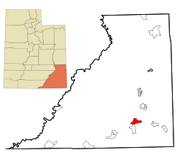
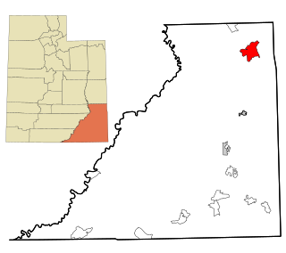
San Juan County is a county in the southeastern portion of the U.S. state of Utah. As of the 2020 United States Census, the population was 14,518. Its county seat is Monticello, while its most populous city is Blanding. The Utah State Legislature named the county for the San Juan River, itself named by Spanish explorers.
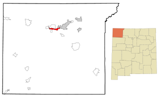
<span class="mw-page-title-main">San Juan County, New Mexico</span> County in New Mexico, United States

San Juan County is located in the U.S. state of New Mexico. As of the 2020 census, the population was 121,661 making it the fifth-most populous county in New Mexico. Its county seat is Aztec. The county was created in 1887.

<span class="mw-page-title-main">Chilchinbito, Arizona</span> CDP in Navajo County, Arizona

Chilchinbito is a town located on the Navajo Nation, whose lands spans four state boundary lines in the Four Corners region of the United States. The town of Chilchinbito is a census-designated place (CDP) specifically in Navajo County, Arizona, United States. The population was 506 at the 2010 census. Chilchinbito is also considered to be the source of coronavirus infections on the Navajo Nation, possibly traced to the annual meeting of the Church of the Nazarene's numerous branches, on March 7, 2020. COVID-19 federal relief funds for medical care on the Navajo Nation were being redirected to a non-Native for-profit corporation, and a legal suit is pending.

<span class="mw-page-title-main">McCaysville, Georgia</span> City in Georgia, United States

McCaysville is a city in Fannin County, Georgia, United States. The population was 1,149 at the 2020 census.

<span class="mw-page-title-main">Naschitti, New Mexico</span> CDP in New Mexico, United States

Naschitti is a census-designated place (CDP) in San Juan County, New Mexico, United States. The population was 360 at the 2000 census. It is part of the Farmington Metropolitan Statistical Area. The town was established in 1886, when Tom Bryan set up a trading post east of the Chuska Mountains. With a Navajo name, Naschitti means "badger springs."

<span class="mw-page-title-main">Nenahnezad, New Mexico</span> CDP in New Mexico, United States

Nenahnezad is a census-designated place (CDP) in San Juan County, New Mexico, United States. The population was 726 at the 2000 census. Nenahnezad is a Chapter community just to the south of Fruitland, between the towns of Farmington and Shiprock. It is part of the Farmington Metropolitan Statistical Area.

<span class="mw-page-title-main">Newcomb, New Mexico</span> CDP in New Mexico, United States

Newcomb is a census-designated place (CDP) in San Juan County, New Mexico, United States. The population was 387 at the 2000 census. It is part of the Farmington Metropolitan Statistical Area.

<span class="mw-page-title-main">Sanostee, New Mexico</span> CDP in New Mexico, United States

Sanostee is a census-designated place (CDP) in San Juan County, New Mexico, United States. The population was 429 at the 2000 census. It is part of the Farmington Metropolitan Statistical Area.

<span class="mw-page-title-main">Shiprock, New Mexico</span> Town in New Mexico, USA

Shiprock is an unincorporated community on the Navajo reservation in San Juan County, New Mexico, United States. The population was 7,718 people in the 2020 census. For statistical purposes, the United States Census Bureau has defined Shiprock as a census-designated place (CDP). It is part of the Farmington Metropolitan Statistical Area.

<span class="mw-page-title-main">Upper Fruitland, New Mexico</span> CDP in New Mexico, United States

Upper Fruitland is a census-designated place (CDP) in San Juan County, New Mexico, United States. The population was 1,664 at the 2000 census. It is part of the Farmington Metropolitan Statistical Area.

<span class="mw-page-title-main">Syracuse, Utah</span> City in Utah, United States

Syracuse is a city in Davis County, Utah, United States. It is situated between the Great Salt Lake and Interstate 15, about 30 miles (48 km) north of Salt Lake City. It is part of the Ogden–Clearfield, Utah Metropolitan Statistical Area. The city has seen rapid growth and development since the 1990s. The city population was 24,331 at the time of the 2010 census, an increase of 158.9% since the 2000 census.

<span class="mw-page-title-main">Brian Head, Utah</span> Town in Utah, United States

Brian Head is a town in Iron County, Utah, United States. The population was 83 at the 2010 census, a significant decrease from the 2000 figure of 118.

<span class="mw-page-title-main">Aneth, Utah</span> CDP in Utah, United States

Aneth is a census-designated place (CDP) in San Juan County, Utah, United States. The population was 598 at the 2000 census. The origin of the name Aneth is obscure.
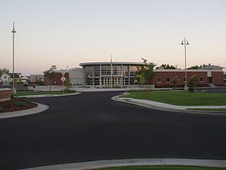
<span class="mw-page-title-main">Halchita, Utah</span> CDP in Utah, United States

Halchita is a census-designated place (CDP) in San Juan County, Utah, United States. The population was 270 at the 2000 census.

<span class="mw-page-title-main">Mexican Hat, Utah</span> Human settlement in Utah, USA

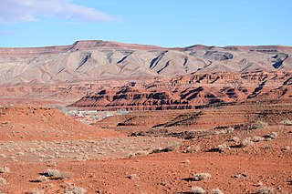
Mexican Hat is a census-designated place (CDP) in Utah in the United States. It is on the San Juan River on the northern edge of the Navajo Nation's borders in south-central San Juan County. The population was 31 in the 2010 census, a sharp decline from the previous two censuses.

<span class="mw-page-title-main">Montezuma Creek, Utah</span> Census-designated place in Utah, United States

Montezuma Creek is a census-designated place (CDP) in San Juan County, Utah, United States. The population was 335 at the 2010 census, a decrease from the 2000 figure of 507.

<span class="mw-page-title-main">Navajo Mountain, Utah</span> Census-designated place in San Juan County, Utah, United States

Navajo Mountain is a census-designated place (CDP) on the Navajo Nation in southwestern San Juan County, Utah, United States. The 2020 census was recorded as 450.

<span class="mw-page-title-main">Tselakai Dezza, Utah</span> CDP in Utah, United States

Tselakai Dezza is a census-designated place (CDP) in San Juan County, Utah, United States. The population was 103 at the 2000 census.

<span class="mw-page-title-main">Ephraim, Utah</span> City in Utah, United States

Ephraim is a city in Sanpete County, Utah, United States. The population was 5,611 at the 2020 census, making it the largest city in Sanpete County. It is the location of Snow College and is located along U.S. Route 89.

<span class="mw-page-title-main">Oljato–Monument Valley, Utah</span> CDP in Utah, United States

Oljato-Monument Valley is a census-designated place (CDP) in San Juan County, Utah, United States. The population was 864 at the 2000 census.

References

  1. 1 2 3 U.S. Geological Survey Geographic Names Information System: Bluff, Utah
  2. "Bluff Town History - Bluff, Utah". November 10, 2019.
  3. "2019 U.S. Gazetteer Files". United States Census Bureau. Retrieved August 7, 2020.
  4. 1 2 "Population and Housing Unit Estimates". United States Census Bureau. May 24, 2020. Retrieved May 27, 2020.
  5. 1 2 "U.S. Census website". United States Census Bureau . Retrieved January 31, 2008.
  6. "Town of Bluff Government". Archived from the original on September 8, 2018. Retrieved August 4, 2023.
  7. 1 2 "Bluff Town History | Bluff, Utah". November 10, 2019.
  8. Van Atta, Dale (January 22, 1977). "You name it - there's a town for it". The Deseret News. p. 15. Retrieved October 18, 2015.
  9. Bluff, UT, 7.5 Minute Topographic Quadrangle, USGS, 1989
  10. "Census of Population and Housing". Census.gov. Retrieved June 4, 2016.
  11. "Bluff, Utah Balloon Festival Schedule of Events". June 17, 2008. Archived from the original on June 17, 2008.
  12. "Events in Bluff | Bluff, Utah". June 16, 2015.