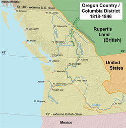
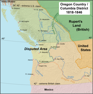
Oregon Country was a large region of the Pacific Northwest of North America that was subject to a long dispute between the United Kingdom and the United States in the early 19th century. The boundaries of the area, which had been created by the Treaty of 1818 without recognizing indigenous claims to the area, consisted of the land north of 42°N latitude, south of 54°40′N latitude, and west of the Rocky Mountains down to the Pacific Ocean and east to the Continental Divide. Article III of the 1818 treaty gave joint control to both nations for ten years, allowed land to be claimed, and guaranteed free navigation to all mercantile trade. However, both countries disputed the terms of the international treaty. Oregon Country was the American name while the British used Columbia District for the region.[1] Meanwhile, Indigenous nations had lived in the area since time immemorial, though with little legal recognition in the American and British legal systems. Evidence along the Salmon River shows people lived there at least 16,000 years ago, and may have populated the continent after migrating along the Pacific Coast, then following up the Columbia River into the interior.[2]
British and FrenchCanadianfur traders had entered Oregon Country prior to 1810 before the arrival of American settlers from the mid-1830s onwards, which led to the foundation of the Provisional Government of Oregon. Its coastal areas north from the Columbia River were frequented by ships from all nations engaged in the maritime fur trade, with many vessels between the 1790s and 1810s coming from Boston. The Hudson's Bay Company, whose Columbia Department comprised most of the Oregon Country and north into New Caledonia and beyond 54°40′N, with operations reaching tributaries of the Yukon River, managed and represented British interests in the region.[3]
The earliest evidence of the name "Oregon" has Spanish origins. The term orejón comes from the historical chronicle Relación de la Alta y Baja California (1598)[5] which was written by the New Spaniard Rodrigo Motezuma and which made reference to the Columbia River when the Spanish explorers penetrated into the North American territory that became part of the Viceroyalty of New Spain. This chronicle is the first topographical and linguistic source with respect to the place name Oregon. There are also two other sources with Spanish origins such as the name Oregano, which grows in the southern part of the region. It is most probable that the American territory was named by the Spaniards, as there are some populations in Spain such as "Arroyo del Oregón", which is in the province of Ciudad Real, also considering that the individualization in Spanish language el Orejón with the mutation of the letter g instead of j.[6]
Another theory is that French Canadian fur company employees called the Columbia River "hurricane river" le fleuve d'ouragan, because of the strong winds of the Columbia Gorge.[citation needed]George R. Stewart argues in a 1944 article in American Speech that the name came from an engraver's error in a French map published in the early 18th century, on which the Ouisiconsink (Wisconsin River) was spelled "Ouaricon-sint", broken on two lines with the -sint below, so that there appeared to be a river flowing to the west named "Ouaricon".[7][8] This theory was endorsed in Oregon Geographic Names as "the most plausible explanation".[9]
David Thompson, working for the Montreal-based North West Company, explored much of the region beginning in 1807, with his friend and colleague Simon Fraser, following the Fraser River to its mouth in 1808, attempting to ascertain whether it was the Columbia, as had been theorized about its northern reaches through New Caledonia, where it was known by its Dakleh name as the "Tacoutche Tesse". Thompson was the first European to voyage down the entire length of Columbia River. Along the way, his party camped at the junction with the Snake River on July 9, 1811. He erected a pole and a notice claiming the country for the United Kingdom and stating the intention of the North West Company to build a trading post on the site. Later in 1811, on the same expedition, he finished his survey of the entire Columbia, arriving at a partially constructed Fort Astoria two months after the departure of John Jacob Astor's ill-fated Tonquin.[11]
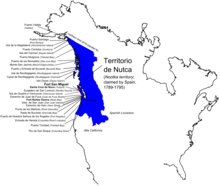
Spanish territorial claims on the West Coast of North America in the 18th century
The Oregon Country was originally claimed by Great Britain, France, Russia, and Spain; the Spanish claim was later taken up by the United States. The extent of the region being claimed was vague at first, evolving over decades into the specific borders specified in the U.S.-British treaty of 1818. The United States based its claim in part on Robert Gray's entry of the Columbia River in 1792 and the Lewis and Clark Expedition. Great Britain based its claim in part on British overland explorations of the Columbia River by David Thompson and on prior discovery and exploration along the coast. Spain's claim was based on the Inter caetera and Treaty of Tordesillas of 1493–94, as well as explorations of the Pacific coast in the late 18th century.[12] Russia based its claim on its explorations and trading activities in the region and asserted its ownership of the region north of the 51st parallel by the Ukase of 1821, which was quickly challenged by the other powers and withdrawn to 54°40′N by separate treaties with the U.S. and Britain in 1824 and 1825, respectively.[13]
Spain gave up its claims of exclusivity via the Nootka Conventions of the 1790s. In the Nootka Conventions, which followed the Nootka Crisis, Spain granted Britain rights to the Pacific Northwest, although it did not establish a northern boundary for Spanish California, nor did it extinguish Spanish rights to the Pacific Northwest.[14] Spain later relinquished any remaining claims to territory north of the 42nd parallel to the United States as part of the Adams-Onís Treaty of 1819. In the 1820s, Russia gave up its claims south of 54°40′ and east of the 141st meridian in separate treaties with the United States and Britain.[15]
Meanwhile, the United States and Britain negotiated the Anglo-American Convention of 1818, which extended the boundary between their territories west along the 49th parallel to the Rocky Mountains. The two countries agreed to "joint occupancy" of the land west of the Rockies to the Pacific Ocean.[16]
In 1843, settlers established their own government, called the Provisional Government of Oregon. A legislative committee drafted a code of laws known as the Organic Law. It included the creation of an executive committee of three, a judiciary, militia, land laws, and four counties. There was vagueness and confusion over the nature of the 1843 Organic Law, in particular whether it was constitutional or statutory. In 1844, a new legislative committee decided to consider it statutory. The 1845 Organic Law made additional changes, including allowing the participation of British subjects in the government. Although the Oregon Treaty of 1846 settled the boundaries of U.S. jurisdiction, the provisional government continued to function until 1849, when the first governor of Oregon Territory arrived.[17] A faction of Oregon politicians hoped to continue Oregon's political evolution into an independent nation, but the pressure to join the United States prevailed by 1848, four months after the Mexican–American War.[18]
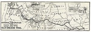
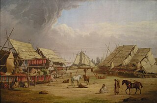
Fort Vancouver in 1845The Columbia River and its tributaries, showing modern political boundaries. In 1811 David Thompson navigated its entire length.Route of the York Factory Express, 1820s to 1840s, with modern political boundaries shownThe Oregon trail started in St. Louis, Missouri.
In 1805, the American Lewis and Clark Expedition marked the first official American exploration of the area, creating the first temporary settlement of Euro-Americans in the area near the mouth of the Columbia River at Fort Clatsop. Two years later in 1807, David Thompson of the Montreal-based North West Company penetrated the Oregon Country from the north, via Athabasca Pass, near the headwaters of the Columbia River. From there he navigated nearly the full length of the river through to the Pacific Ocean.
In 1810, John Jacob Astor commissioned and began the construction of the American Pacific Fur Company fur-trading post at Fort Astoria, just 5 miles (8 kilometers) from the site of Lewis and Clark's former Fort Clatsop, completing construction of the first permanent Euro-American settlement in the area in 1811. This settlement later served as the nucleus of present-day Astoria, Oregon. During the period of the construction of Fort Astoria, Thompson traveled down the Columbia River, noting the partially constructed American Fort Astoria only two months after the departure of the supply ship Tonquin.
Along the way, Thompson had set foot on and claimed for the British Crown, the lands in the vicinity of the future Fort Nez Percés site at the confluence of the Columbia and Snake rivers. This claim initiated a very brief era of competition between American and British fur traders. During the War of 1812, Fort Astoria was captured by the British and sold to the North West Company. Under British control, Fort Astoria was renamed Fort George.[19]
In 1821 when the North West Company was merged with the Hudson's Bay Company, the British Parliament moved to impose the laws of Upper Canada upon British subjects in Columbia District and Rupert's Land, and issued the authority to enforce those laws to the Hudson's Bay Company. Chief FactorJohn McLoughlin was appointed manager of the district's operations in 1824. He moved the regional company headquarters to Fort Vancouver (modern Vancouver, Washington) in 1824. Fort Vancouver became the centre of a thriving colony of mixed origin, including Scottish Canadians and Scots, English, French Canadians, Hawaiians, Algonkians, and Iroquois, as well as the offspring of company employees who had intermarried with various local native populations.
Astor continued to compete for Oregon Country furs through his American Fur Company operations in the Rockies.[20] In the 1820s, a few American explorers and traders visited this land beyond the Rocky Mountains. Long after the Lewis and Clark Expedition and also after the consolidation of the fur trade in the region by the Canadian fur companies, American mountain men such as Jedediah Smith and Jim Beckwourth came roaming into and across the Rocky Mountains, following Indian trails through the Rockies to California and Oregon. They sought beaver pelts and other furs, which were obtained by trapping. These were difficult to obtain in the Oregon Country because of the Hudson's Bay Company policy of creating a "fur desert": deliberate over-hunting of the area's frontiers, so that American trades would find nothing there.[21] The mountain men, like the Metis employees of the Canadian fur companies, adopted Indian ways, and many of them married Native American women.[22]
Reports of Oregon Country eventually circulated in the eastern United States. Some churches decided to send missionaries to convert the Indians. Jason Lee, a Methodist minister from New York, was the first Oregon missionary. He built a mission school for Indians in the Willamette Valley in 1834. American settlers began to arrive from the east via the Oregon Trail starting in the early 1840s and came in increasing numbers each subsequent year. Increased tension led to the Oregon boundary dispute. Both sides realized that settlers would ultimately decide who controlled the region. The Hudson's Bay Company, which had previously discouraged settlement as it conflicted with the lucrative fur trade, belatedly reversed their position. In 1841, on orders from Sir George Simpson, James Sinclair guided more than 100 settlers from the Red River Colony to settle on HBC farms near Fort Vancouver. The Sinclair expedition crossed the Rockies into the Columbia Valley, near present-day Radium Hot Springs, British Columbia, then traveled southwest down the Kootenai River and Columbia River following the southern portion of the well-established York Factory Express trade route.[23]
The Canadian effort proved to be too little, too late. In what was dubbed "The Great Migration of 1843" or the "Wagon Train of 1843", an estimated 700 to 1,000 American emigrants came to Oregon, decisively tipping the balance.[24][25]
Mural on the walls of the Oregon Capitol Building depicting the provisional government seal
In 1843, settlers in the Willamette Valley established a provisional government at Champoeg. Political pressure in the United States urged the occupation of all the Oregon Country. Expansionists in the American South wanted to annex Texas, while their counterparts in the northeast wanted to annex the Oregon Country. It was seen as significant that the expansions be parallel, as the relative proximity to other states and territories made it appear likely that Texas would be pro-slavery and Oregon against slavery.[citation needed]
In the 1844 U.S. Presidential election, the Democrats had called for expansion into both areas. After his election as president, however, James K. Polk supported the 49th parallel as a northern limit for U.S. annexation in Oregon Country. It was Polk's uncompromising support for expansion into Texas and relative silence on the Oregon boundary dispute that led to the phrase "Fifty-Four Forty or Fight!", referring to the northern border of the region and often erroneously attributed to Polk's campaign. The goal of the slogan was to rally Southern expansionists (some of whom wanted to annex only Texas in an effort to tip the balance of slave/free states and territories in favor of slavery) to support the effort to annex Oregon Country, appealing to the popular belief in manifest destiny. The British government, meanwhile, sought control of all territory north of the Columbia River.[26]
Despite the posturing, neither country really wanted to fight what would have been the third war in 70 years against the other. The two countries eventually came to a peaceful agreement in the 1846 Oregon Treaty that divided the territory west of the Continental Divide along the 49th parallel to Georgia Strait, with the whole of Vancouver Island remaining under British control. This border today divides British Columbia from neighboring Washington, Idaho, and Montana.
Hudson's Bay Company
In 1843 the HBC shifted its Columbia Department headquarters from Fort Vancouver to Fort Victoria on Vancouver Island. The plan to move to more northern locations dated back to the 1820s. George Simpson was the main force behind the move north; John McLoughlin became the main hindrance. McLoughlin had devoted his life's work to the Columbia business, and his personal interests were increasingly linked to the growing settlements in the Willamette Valley. He fought Simpson's proposals to move north in vain. By the time Simpson made the final decision in 1842 to move the headquarters to Vancouver Island, he had had many reasons for doing so. There was a dramatic decline in the fur trade across North America. In contrast the HBC was seeing increasing profits with coastal exports of salmon and lumber to Pacific markets such as Hawaii. Coal deposits on Vancouver Island had been discovered, and steamships such as the Beaver had shown the growing value of coal, economically and strategically. A general HBC shift toward Pacific shipping and away from the interior of the continent made Victoria Harbour much more suitable than Fort Vancouver's location on the Columbia River. The Columbia Bar at the river's mouth was dangerous and routinely meant weeks or months of waiting for ships to cross. The largest ships could not enter the river at all. The growing numbers of American settlers along the lower Columbia gave Simpson reason to question the long term security of Fort Vancouver. He worried, rightfully so, that the final border resolution would not follow the Columbia River. By 1842, he thought it more likely that the United States would at least demand Puget Sound, and the British government would accept a border as far north as the 49th parallel, excluding Vancouver Island. Despite McLoughlin's stalling, the HBC had begun the process of shifting away from Fort Vancouver and toward Vancouver Island and the northern coast in the 1830s. The increasing number of American settlers arriving in the Willamette Valley after 1840 served to make the need more pressing.[27]
In 1848, the U.S. portion of the Oregon Country was formally organized as the Oregon Territory. In 1849, Vancouver Island became a British Crown colony—the Colony of Vancouver Island—with the mainland being organized into the Colony of British Columbia in 1858. Shortly after the establishment of Oregon Territory, there was an effort to split off the region north of the Columbia River. As a result of the Monticello Convention, Congress approved the creation of Washington Territory in early 1853. PresidentMillard Fillmore approved the new territory on March 2, 1853.[28]
Descriptions of the land and settlers
Alexander Ross, an early Scottish Canadian fur trader, describes the lower Columbia River area of the Oregon Country (known to him as the Columbia District):
The banks of the river throughout are low and skirted in the distance by a chain of moderately high lands on each side, interspersed here and there with clumps of wide spreading oaks, groves of pine, and a variety of other kinds of woods. Between these high lands lie what is called the valley of the Wallamitte [sic], the frequented haunts of innumerable herds of elk and deer ... In ascending the river the surrounding country is most delightful, and the first barrier to be meet with is about forty miles up from its mouth. Here the navigation is interrupted by a ledge of rocks, running across the river from side to side in the form of an irregular horseshoe, over which the whole body of water falls at one leap down a precipice of about forty feet, called the Falls.
After living in Oregon from 1843 to 1848, Peter H. Burnett wrote:
[Oregonians] were all honest, because there was nothing to steal; they were all sober, because there was no liquor to drink; there were no misers, because there was no money to hoard; and they were all industrious, because it was work or starve.[29][30]
Cascadia (independence movement), a contemporary movement to make the Cascadian bioregion, roughly covering the same area as the Oregon country, an independent country
John McLoughlin, baptized Jean-Baptiste McLoughlin, was a French-Canadian, later American, Chief Factor and Superintendent of the Columbia District of the Hudson's Bay Company at Fort Vancouver from 1824 to 1845. He was later known as the "Father of Oregon" for his role in assisting the American cause in the Oregon Country. In the late 1840s, his general store in Oregon City was famous as the last stop on the Oregon Trail.
Fort Vancouver was a 19th century fur trading post that was the headquarters of the Hudson's Bay Company's Columbia Department, located in the Pacific Northwest. Named for Captain George Vancouver, the fort was located on the northern bank of the Columbia River in present-day Vancouver, Washington. The fort was a major center of the regional fur trading. Every year trade goods and supplies from London arrived either via ships sailing to the Pacific Ocean or overland from Hudson Bay via the York Factory Express. Supplies and trade goods were exchanged with a plethora of Indigenous cultures for fur pelts. Furs from Fort Vancouver were often shipped to the Chinese port of Guangzhou where they were traded for Chinese manufactured goods for sale in the United Kingdom. At its pinnacle, Fort Vancouver watched over 34 outposts, 24 ports, six ships, and 600 employees. Today, a full-scale replica of the fort, with internal buildings, has been constructed and is open to the public as Fort Vancouver National Historic Site.
The Oregon boundary dispute or the Oregon Question was a 19th-century territorial dispute over the political division of the Pacific Northwest of North America between several nations that had competing territorial and commercial aspirations in the region.
The history of British Columbia covers the period from the arrival of Paleo-Indians thousands of years ago to the present day. Prior to European colonization, the lands encompassing present-day British Columbia were inhabited for millennia by a number of First Nations.
Fort Hall was a fort in the Western United States that was built in 1834 as a fur trading post by Nathaniel Jarvis Wyeth. It was located on the Snake River in the eastern Oregon Country, now part of present-day Bannock County in southeastern Idaho. Wyeth was an inventor and businessman from Boston, Massachusetts, who also founded a post at Fort William, in present-day Portland, Oregon, as part of a plan for a new trading and fisheries company. In 1837, unable to compete with the powerful British Hudson's Bay Company, based at Fort Vancouver, Wyeth sold both posts to it. Great Britain and the United States both operated in the Oregon Country in these years.
The Convention respecting fisheries, boundary and the restoration of slaves, also known as the London Convention, Anglo-American Convention of 1818, Convention of 1818, or simply the Treaty of 1818, is an international treaty signed in 1818 between the United States and the United Kingdom. This treaty resolved standing boundary issues between the two nations. The treaty allowed for joint occupation and settlement of the Oregon Country, known to the British and in Canadian history as the Columbia District of the Hudson's Bay Company, and including the southern portion of its sister district New Caledonia.
Fort Astoria was the primary fur trading post of John Jacob Astor's Pacific Fur Company (PFC). A maritime contingent of PFC staff was sent on board the Tonquin, while another party traveled overland from St. Louis. This land based group later became known as the Astor Expedition. Built at the entrance of the Columbia River in 1811, Fort Astoria was the first American-owned settlement on the Pacific coast of North America.
New Caledonia was a fur-trading district of the Hudson's Bay Company that comprised the territory of the north-central portions of present-day British Columbia, Canada. Though not a British colony, New Caledonia was part of the British claim to North America. Its administrative centre was Fort St. James. The rest of what is now mainland British Columbia was called the Columbia Department by the British, and the Oregon Country by the Americans. Even before the partition of the Columbia Department by the Oregon Treaty in 1846, New Caledonia was often used to describe anywhere on the mainland not in the Columbia Department, such as Fort Langley in the Fraser Valley.
Fort Victoria began as a fur trading post of the Hudson’s Bay Company and was the headquarters of HBC operations in the Columbia District, a large fur trading area now part of the province of British Columbia, Canada and the U.S. state of Washington. Construction of Fort Victoria in 1843 highlighted the beginning of a permanent British settlement now known as Victoria, the capital city of British Columbia. The fort itself was demolished in November 1864 as the town continued to grow as a commercial centre serving the local area as well as trading with California, Washington Territory, the United Kingdom, and others.
The trade center Fort Colvile was built by the Hudson's Bay Company (HBC) at Kettle Falls on the Columbia River in 1825 and operated in the Columbia fur district of the company. Named for Andrew Colvile, a London governor of the HBC, the fort was a few miles west of the present site of Colville, Washington. It was an important stop on the York Factory Express trade route to London via the Hudson Bay. The HBC for some time considered Fort Colvile second in importance only to Fort Vancouver, near the mouth of the Columbia, until the foundation of Fort Victoria.
Fort Nisqually was an important fur trading and farming post of the Hudson's Bay Company in the Puget Sound area, part of the Hudson's Bay Company's Columbia Department. It was located in what is now DuPont, Washington. Today it is a living history museum located in Tacoma, Washington, USA, within the boundaries of Point Defiance Park. The Fort Nisqually Granary, moved along with the Factor's House from the original site of the second fort to this park, is a U.S. National Historic Landmark. Built in 1843, the granary is the oldest building in Washington state and one of the only surviving examples of a Hudson's Bay Company "post-and-plank" structure. The Factor's House and the granary are the only surviving Hudson's Bay Company buildings in the United States.
The Columbia District was a fur trading district in the Pacific Northwest region of British North America in the 19th century. Much of its territory overlapped with the disputed Oregon Country. It was explored by the North West Company between 1793 and 1811, and established as an operating fur district around 1810. The North West Company was absorbed into the Hudson's Bay Company in 1821 under which the Columbia District became known as the Columbia Department. The Oregon Treaty of 1846 marked the effective end of the Hudson's Bay Company's Columbia Department.
The Colony of Vancouver Island, officially known as the Island of Vancouver and its Dependencies, was a Crown colony of British North America from 1849 to 1866, after which it was united with the mainland to form the Colony of British Columbia. The united colony joined Canadian Confederation, thus becoming part of Canada, in 1871. The colony comprised Vancouver Island and the Gulf Islands of the Strait of Georgia.
Oregon pioneer history (1806–1890) is the period in the history of Oregon Country and Oregon Territory, in the present day state of Oregon and Northwestern United States.
The Puget Sound Agricultural Company (PSAC), with common variations of the name including Puget Sound or Puget's Sound, was a subsidiary joint stock company formed in 1840 by the Hudson's Bay Company (HBC). Its stations operated within the Pacific Northwest, in the HBC administrative division of the Columbia Department. The RAC-HBC Agreement was signed in 1839 between the Russian-American Company and the HBC, with the British to now supply the various trade posts of Russian America. It was hoped by the HBC governing committee that independent American merchants, previously a major source of foodstuffs for the RAC, would be shut out of the Russian markets and leave the Maritime fur trade.
Fort William was a fur trading outpost built in 1834 by the American Nathaniel Jarvis Wyeth, a Boston merchant, backed by American investors. It was located on the Columbia River on Wappatoo Island near the future Portland, Oregon. After a few years, in 1837 Wyeth sold the post to the British Hudson's Bay Company, which had much more power in the region from its base at Fort Vancouver on the north side of the Columbia River near Fort William.
The York Factory Express, usually called "the Express" and also the Columbia Express and the Communication, was a 19th-century fur brigade operated by the Hudson's Bay Company (HBC). Roughly 4,200 kilometres (2,600 mi) in length, it was the main overland connection between HBC headquarters at York Factory and the principal depot of the Columbia Department, Fort Vancouver.
Thomas McKay (1796–1849) was an Anglo-Métis Canadian fur trader who worked mainly in the Pacific Northwest for the Pacific Fur Company (PFC), the North West Company (NWC), and the Hudson's Bay Company (HBC). He was a fur brigade leader and explorer of the Columbia District and later became a U.S. citizen and an early settler of Oregon.
Fort Stikine was a fur trade post and fortification in what is now the Alaska Panhandle, at the site of the present-day of Wrangell, Alaska. Originally built as the Redoubt San Dionisio or Redoubt Saint Dionysius in 1834, the site was transferred to the British-owned Hudson's Bay Company as part of a lease signed in the region in 1838, and renamed Fort Stikine when turned into a Hudson's Bay Company post in 1839. The post was closed and decommissioned by 1843 but the name remained for the large village of the Stikine people which had grown around it, becoming known as Shakesville in reference to its ruling Chief Shakes by the 1860s. With the Alaska Purchase of 1867, the fortification became occupied by the US Army and was renamed Fort Wrangel, a reference to Baron von Wrangel, who had been Governor of Russian America when the fort was founded. The site today is now part of the city of Wrangell.
The following is a timeline of the history of Oregon in the United States of America.
References
↑ Meinig, D. W. (1995) [1968]. The Great Columbia Plain (Weyerhaeuser Environmental Classiced.). University of Washington Press. p.104. ISBN0-295-97485-0.
↑ Mackie, Richard Somerset (1997). Trading Beyond the Mountains: The British Fur Trade on the Pacific 1793–1843. Vancouver: University of British Columbia (UBC) Press. p.284. ISBN0-7748-0613-3.
↑ Motezuma, Rodrigo (2002). La isla de oro: relación de la alta y Baja California (1.ed.). Valladolid: Universitas Castellae. ISBN84-92315-67-9.
↑ Fernández-Shaw, Carlos M. (1987). Presencia española en los Estados Unidos (2a ed. aum. y corr.ed.). Madrid: Instituto de Cooperación Iberoamericana, Ediciones Cultura Hispánica. ISBN84-7232-412-5.
↑ Stewart, George R. (1944). "The Source of the Name 'Oregon'". American Speech. Duke University Press. 19 (2): 115–117. doi:10.2307/487012. JSTOR487012.
↑ Chiorazzi, Michael G.; Marguerite Most (2005). Prestatehood Legal Materials. Haworth Press. pp.959–962. ISBN978-0-7890-2056-7. online at Google Books
↑ Meinig, D.W. (1995) [1968]. The Great Columbia Plain (Weyerhaeuser Environmental Classiced.). University of Washington Press. p.52. ISBN0-295-97485-0.
↑ White, Bruce M. (Winter 1999). "The Woman Who Married a Beaver: Trade Patterns and Gender Roles in the Ojibwe Fur Trade". Ethnohistory. Grand Marais, Minnesota. 46 (1): 109–147.
↑ Galbraith, John S. (1954), "The Early History of the Puget's Sound Agricultural Company, 1838-43", Oregon Historical Quarterly, Portland, OR: Oregon Historical Society, 55 (3): 234–259.
↑ Mackie, Richard Somerset (1997). Trading Beyond the Mountains: The British Fur Trade on the Pacific 1793–1843. Vancouver: University of British Columbia (UBC) Press. pp.240–245, 256–262, 264–273, 276. ISBN0-7748-0613-3. online at Google Books
24. Claimed in 1908; territory formed 1962; overlaps portions of Argentine and Chilean claims, borders not enforced but claim not renounced under the Antarctic Treaty.
This page is based on this Wikipedia article Text is available under the CC BY-SA 4.0 license; additional terms may apply. Images, videos and audio are available under their respective licenses.