Australian Antarctic Territory

Last updated

Australian Antarctic Territory
Antarctica, Australia territorial claim.svg
Map of Antarctica indicating Australian territorial claim (red area)
Sovereign state Flag of Australia (converted).svg  Australia
British claim1841
Claim transferred to Australia1933
Main base
and administrative centre
Davis Station
68°34′36″S77°58′03″E / 68.576667°S 77.9675°E / -68.576667; 77.9675
Official languages English
Government Dependency under a constitutional monarchy
  Monarch
Charles III
David Hurley
  Australian government minister
Tanya Plibersek
 Chief Scientist
Nicole Webster
Area
 Total
5,896,500 km2 (2,276,700 sq mi)
Population
 Estimate
less than 1,000
Currency Australian dollar (AU$) (AUD)
Calling code +672 1x
Internet TLD

The Australian Antarctic Territory (AAT) is a part of East Antarctica claimed by Australia as an external territory. It is administered by the Australian Antarctic Division, an agency of the federal Department of Climate Change, Energy, the Environment and Water. The territory's history dates to a claim on Enderby Land made by the United Kingdom in 1841, which was subsequently expanded and eventually transferred to Australia in 1933. It is the largest territory of Antarctica claimed by any nation by area. In 1961, the Antarctic Treaty came into force. Article 4 deals with territorial claims, and although it does not renounce or diminish any pre-existing claims to sovereignty, it also does not prejudice the position of Contracting Parties in their recognition or non-recognition of territorial sovereignty. As a result, only four other countries — New Zealand, the United Kingdom, France, and Norway — recognise Australia's claim to sovereignty in Antarctica. [1]

Contents

Area

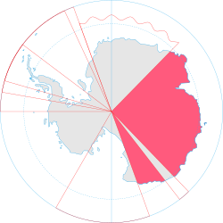
The AAT consists of all the islands and territory south of 60°S and between 44°38′E and 160°E, except for Adélie Land (136°E to 142°E), which divides the territory into Western AAT (the larger portion) and Eastern AAT. [2] It is bounded by Queen Maud Land in the West and by the Ross Dependency in the East. The Australian Antarctic Territory is the largest of any claims to the continent, and covers nearly 5.9 million square kilometres. [3] This makes up about 42 per cent of Antarctica, and would cover about 80 per cent of Mainland Australia. [4] It also corresponds to roughly twice the size of Queen Maud Land, India, Argentina or Kazakhstan. [5] [6] [7]

The territory is mostly inhabited by the staff of research stations. The Australian Antarctic Division administers the area primarily by maintaining three year-round stations—Mawson, Davis, and Casey—which support various research projects. [8]

Subdivisions

Map of districts of Australian Antarctic Territory
.mw-parser-output .legend{page-break-inside:avoid;break-inside:avoid-column}.mw-parser-output .legend-color{display:inline-block;min-width:1.25em;height:1.25em;line-height:1.25;margin:1px 0;text-align:center;border:1px solid black;background-color:transparent;color:black}.mw-parser-output .legend-text{}
Enderby Land
Kemp Land
Mac. Robertson Land
Princess Elizabeth Land
Kaiser Wilhelm II Land
Queen Mary Land
Wilkes Land (showing further subdivisions)
George V Land
Oates Land Districts of Australian Antarctic Territory.svg
Map of districts of Australian Antarctic Territory
  Enderby Land
  Kemp Land
  Mac. Robertson Land
  Princess Elizabeth Land
  Kaiser Wilhelm II Land
  Queen Mary Land
  Wilkes Land (showing further subdivisions)
  George V Land
  Oates Land

The territory is divided into nine districts, which are from west to east: [9]

#DistrictArea (km2)Western
border
Eastern
border
Width
1 Enderby Land 449,900044°38′ E056°25′ E011°47′
2 Kemp Land ...056°25′ E059°34′ E003°09′
3 Mac. Robertson Land 260,000059°34′ E072°35′ E013°01′
4 Princess Elizabeth Land 437,500072°35′ E087°43′ E015°08′
5 Kaiser Wilhelm II Land ...087°43′ E091°54′ E003°11′
6 Queen Mary Land 422,000091°54′ E100°30′ E008°36′
7 Wilkes Land 2,160,000100°30′ E136°11′ E035°41′
8 George V Land 483,000142°02′ E153°45′ E011°43′
9 Oates Land ...153°45′ E160°00′ E006°15′
 Total5,897,000153°45′ E160°00′ E097°44′

These regions are split into two separate areas geographically, with George V Land and Oates Land lying to the east of the French Territorial claim of Adélie Land, and all other districts lying to its west.

Exclusive economic zone

Australia claims an exclusive economic zone (EEZ) from the Australian Antarctic Territory. However, the Australian proclamation of an Antarctic EEZ is contested. The effect of Article IV of the 1959 Antarctic Treaty (which prohibits new territorial claims or the extension of existing claims in the Antarctic) would seem to be that an EEZ cannot be claimed in relation to territory to which that Treaty applies (south of 60° South).[ citation needed ] The provisions of the United Nations Convention on the Law of the Sea (UNCLOS) define the exclusive economic zone of a coastal state as up to 200 nautical miles (370 km) from the baseline from which the territorial sea is measured. [10]

Whaling

Whaling in Australian Antarctic territorial waters is controversial and has received international attention. [11] Anti-whaling protest groups, in particular Sea Shepherd Conservation Society, have been active within the Australian Antarctic territorial waters. Sea Shepherd small boat crews have had multiple encounters with Japanese ships that claim to be on research expeditions while opponents argue this is only a "cover" for banned commercial whaling. [12] [13] The Australian Whale Sanctuary, in Australian Antarctic territory, is not recognised by the government of Japan. [11] Anti-whaling legislation passed by the Australian Government applies to Australian territorial waters. However, Australia's claims of sovereignty over the Australian Antarctic Territory—and thus sovereignty over Australian Antarctic territorial waters—are recognised by only the United Kingdom, New Zealand, France and Norway. [14]

Stations

Davis Station Davis Station November 2005.jpg
Davis Station

Active and closed stations in the territory, from West to East:

StationStatusNationalityLocationDistrict
Molodyozhnaya SeasonalFlag of Russia.svg Russia 67°40′S45°51′E / 67.667°S 45.850°E / -67.667; 45.850 Enderby Land
Mawson PermanentFlag of Australia (converted).svg Australia 67°36′09.7″S62°52′25.7″E / 67.602694°S 62.873806°E / -67.602694; 62.873806 Mac Robertson Land (Mawson Coast)
Soyuz ClosedFlag of Russia.svg Russia 70°35′S68°47′E / 70.583°S 68.783°E / -70.583; 68.783 Mac Robertson Land (Lars Christensen Land)
Druzhnaya ClosedFlag of Russia.svg Russia 69°44′S72°42′E / 69.733°S 72.700°E / -69.733; 72.700 Princess Elizabeth Land (Ingrid Christensen Land)
Bharati PermanentFlag of India.svg  India 69°24′S76°11′E / 69.400°S 76.183°E / -69.400; 76.183 Princess Elizabeth Land (Ingrid Christensen Land)
Zhongshan PermanentFlag of the People's Republic of China.svg  China 69°22′S76°22′E / 69.367°S 76.367°E / -69.367; 76.367 Princess Elizabeth Land (Ingrid Christensen Land)
Law-Racoviță-Negoiță Station SeasonalFlag of Romania.svg  Romania 69°23′18.6″S76°22′46.2″E / 69.388500°S 76.379500°E / -69.388500; 76.379500 Princess Elizabeth Land (Ingrid Christensen Land)
Progress Station PermanentFlag of Russia.svg Russia 69°23′S76°23′E / 69.383°S 76.383°E / -69.383; 76.383 Princess Elizabeth Land (Ingrid Christensen Land)
Davis PermanentFlag of Australia (converted).svg Australia 68°34′35.8″S77°58′02.6″E / 68.576611°S 77.967389°E / -68.576611; 77.967389 Princess Elizabeth Land (Ingrid Christensen Land)
Sovetskaya ClosedFlag of Russia.svg Russia 77°58′S89°16′E / 77.967°S 89.267°E / -77.967; 89.267 Wilhelm II Land
Mirny Station PermanentFlag of Russia.svg Russia 66°33′S93°01′E / 66.550°S 93.017°E / -66.550; 93.017 Queen Mary Land
Komsomolskaya ClosedFlag of Russia.svg Russia 74°05′S97°29′E / 74.083°S 97.483°E / -74.083; 97.483 Queen Mary Land
Vostok PermanentFlag of Russia.svg Russia 78°28′S106°48′E / 78.467°S 106.800°E / -78.467; 106.800 Wilkes Land (Knox Land)
Wilkes Station ClosedFlag of Australia (converted).svg Australia 66°15′25.6″S110°31′32.2″E / 66.257111°S 110.525611°E / -66.257111; 110.525611 Wilkes Land (Budd Land)
Casey PermanentFlag of Australia (converted).svg Australia 66°16′54.5″S110°31′39.4″E / 66.281806°S 110.527611°E / -66.281806; 110.527611 Wilkes Land (Budd Land)
Concordia Station
(Dome C)
PermanentFlag of France.svg France
Flag of Italy.svg Italy
75°06′S123°23′E / 75.100°S 123.383°E / -75.100; 123.383 Wilkes Land (Banzare Land)
Leningradskaya ClosedFlag of Russia.svg Russia 69°30′S159°23′E / 69.500°S 159.383°E / -69.500; 159.383 Oates Land

History

The United Kingdom first claimed Victoria Land on 9 January 1841 and then claimed Enderby Land in 1930. In 1933, a British imperial order transferred most of the territory south of 60° S and between meridians 160° E and 45° E to Australia.

That part of His Majesty's dominions in the Antarctic Seas which comprises all the islands and territories other than Adélie Land which are situated south of the 60th degree of South Latitude and lying between the 160th degree of East Longitude and the 45th degree of East Longitude is hereby placed under the authority of the Commonwealth of Australia. [15]

Australian Antarctic Territory Acceptance Act 1933
That part of the territory in the Antarctic seas which comprises all the islands and territories, other than Adelie Land, situated south of the 60th degree south latitude and lying between the 160th degree east longitude and the 45th degree east longitude, is hereby declared to be accepted by the Commonwealth as a Territory under the authority of the Commonwealth, by the name of the Australian Antarctic Territory. C2004C00416 / Australian Antarctic Territory Acceptance Act 1933 ( Cth )

The borders with Adélie Land were fixed definitively in 1938. In 1947, Britain transferred Heard Island and McDonald Islands to the territory. On 13 February 1954, [16] Mawson Station was established as the first Australian station on the continent proper.

Recognition and promotion of Australian sovereignty

Australia's claim to sovereignty over the Australian Antarctic Territory is recognised by the United Kingdom, New Zealand, France and Norway. [17] Japan does not recognise the Australian claim to the Australian Antarctic territorial waters in which Japanese ships conduct whaling. [18]

In 2016 the Australian Government formulated an Antarctic Strategy and 20 Year "Action Plan" to improve overland transport capabilities and aviation access to the continent. The plan incorporated a strategy to protect the Antarctic environment and maintain an indefinite ban on mining and oil drilling. The construction of a research and resupply icebreaker vessel was also planned. [19] The 25,000-tonne RSV Nuyina was delivered in 2021 and was immediately employed in support of the Casey Station. It is envisaged that the ship will support scientific research over the next 30 years. [20]

Through "Operation Southern Discovery", elements of the Australian Defence Force also provide annual support for the Australian Antarctic Division and the Australian Antarctic Program (AAP) in regional scientific, environmental and economic activities. [21] The Royal Australian Air Force provides air logistical support using C-17 transport aircraft supported by KC-30 tanker aircraft to supply Wilkins airfield in Antarctica. [22]

Mining in Antarctica

During the early 1980s there was a brief debate in Australia on whether or not to allow mining on the mineral-rich continent. [23] Several mining proposals have been discussed and have all been rejected. [24]

On 9 August 2011, influential Australian think-tank, the Lowy Institute, published a report warning Canberra against complacency when it comes to its claim. [25] The global treaty banning resource exploitation becomes reviewable in 2041, [26] and some states may then decide to withdraw from it considering the continent's mineral deposits. These include coal seams, manganese, iron and uranium, while Antarctica's forecast oil reserves are estimated as among the largest in the world after Saudi Arabia and Venezuela. Lowy's national security fellow Ellie Fogarty said in the paper that Australia cannot adequately patrol its claim, lacking the kind of ski-planes it needs to reach some areas.

Postage stamps

This 1959 cover commemorated the opening of the Wilkes post office. Cover AAT 1959.jpg
This 1959 cover commemorated the opening of the Wilkes post office.

Australia issues postage stamps for the Australian Antarctic Territory. The first issues came in 1957, and sporadically thereafter, settling into a pattern of an annual issue by the 1990s. All have been Antarctic-themed, and all are valid for postage in Australia and its territories, including Antarctica.

Telephone connections

Assigned the country calling code +672 1[0-4] XXXX, the four stations and the Aurora Australis operated by the Australian Antarctic Division can be reached by direct calling from anywhere in the world. The area codes are 10 for Davis, 11 for Mawson, 12 for Casey, 13 for Macquarie Island and 14 for Wilkins and the Aurora Australis, in each case followed by four additional digits.

People

As of May 2018 the AAT was believed to have a population of around 80 people during winters and 200 during summers. [27]

See also

Related Research Articles

<span class="mw-page-title-main">Antarctic Treaty System</span> International treaties concerning Antarctica

The Antarctic Treaty and related agreements, collectively known as the Antarctic Treaty System (ATS), regulate international relations with respect to Antarctica, Earth's only continent without a native human population. It was the first arms control agreement established during the Cold War, designating the continent as a scientific preserve, establishing freedom of scientific investigation, and banning military activity; for the purposes of the treaty system, Antarctica is defined as all the land and ice shelves south of 60°S latitude. Since September 2004, the Antarctic Treaty Secretariat, which implements the treaty system, is headquartered in Buenos Aires, Argentina.

<span class="mw-page-title-main">French Southern and Antarctic Lands</span> Overseas Territory of France

The French Southern and Antarctic Lands is an overseas territory of France. It consists of:

  1. Adélie Land, the French claim on the continent of Antarctica.
  2. Crozet Islands, a group in the southern Indian Ocean, south of Madagascar.
  3. Kerguelen Islands, a group of volcanic islands in the southern Indian Ocean, southeast of Africa.
  4. Saint Paul and Amsterdam Islands, a group to the north of the Kerguelen Islands.
  5. Scattered Islands, a dispersed group of islands around the coast of Madagascar.
<span class="mw-page-title-main">History of Antarctica</span>

The history of Antarctica emerges from early Western theories of a vast continent, known as Terra Australis, believed to exist in the far south of the globe. The term Antarctic, referring to the opposite of the Arctic Circle, was coined by Marinus of Tyre in the 2nd century AD.

<span class="mw-page-title-main">Douglas Mawson</span> Australian geologist and explorer of the Antarctic (1882–1958)

Sir Douglas Mawson OBE FRS FAA was an Australian geologist, Antarctic explorer, and academic. Along with Roald Amundsen, Robert Falcon Scott, and Sir Ernest Shackleton, he was a key expedition leader during the Heroic Age of Antarctic Exploration.

<span class="mw-page-title-main">Ross Dependency</span> New Zealands territorial claim in Antarctica

The Ross Dependency is a region of Antarctica defined by a sector originating at the South Pole, passing along longitudes 160° east to 150° west, and terminating at latitude 60° south. It is claimed by New Zealand, a claim accepted only by the other six countries with territorial claims in Antarctica. Under the 1961 Antarctic Treaty, of which all territorial claimants are signatories, including New Zealand, all claims are held in abeyance. Article IV states: "No acts or activities taking place while the present Treaty is in force shall constitute a basis for asserting, supporting or denying a claim to territorial sovereignty in Antarctica or create any rights of sovereignty in Antarctica".

<span class="mw-page-title-main">Mawson Station</span> Antarctic station in Australian Antarctic Territory

Mawson Station, commonly called Mawson, is one of three permanent bases and research outposts in Antarctica managed by the Australian Antarctic Division (AAD). Mawson lies in Holme Bay in Mac. Robertson Land, East Antarctica in the Australian Antarctic Territory, a territory claimed by Australia. Established in 1954, Mawson is Australia's oldest Antarctic station and the oldest continuously inhabited Antarctic station south of the Antarctic Circle. It houses approximately 20 personnel over winter and up to 53 in summer.

<span class="mw-page-title-main">British Antarctic Territory</span> British Overseas Territory

The British Antarctic Territory (BAT) is a sector of Antarctica claimed by the United Kingdom as one of its 14 British Overseas Territories, of which it is by far the largest by area. It comprises the region south of 60°S latitude and between longitudes 20°W and 80°W, forming a wedge shape that extends to the South Pole, overlapped by the Antarctic claims of Argentina and Chile. The claim to the region has been suspended since the Antarctic Treaty came into force in 1961.

A dependent territory, dependent area, or dependency is a territory that does not possess full political independence or sovereignty as a sovereign state, yet remains politically outside the controlling state's integral area.

<span class="mw-page-title-main">Adélie Land</span> Territory in Antarctica claimed by France

Adélie Land or Adélie Coast is a claimed territory of France located on the continent of Antarctica. It stretches from a portion of the Southern Ocean coastline all the way inland to the South Pole. France has administered it as one of five districts of the French Southern and Antarctic Lands since 1955 and applied the Antarctic Treaty System rules since 1961. Article 4 of the Antarctic Treaty deals with territorial claims, and although it does not renounce or diminish any preexisting claims to sovereignty, it also does not prejudice the position of contracting parties in their recognition or non-recognition of territorial sovereignty. France has had a permanent station in Adélie Land since 9 April 1950.

<span class="mw-page-title-main">Exclusive economic zone</span> Adjacent sea zone in which a state has special rights

An exclusive economic zone (EEZ), as prescribed by the 1982 United Nations Convention on the Law of the Sea, is an area of the sea in which a sovereign state has exclusive rights regarding the exploration and use of marine resources, including energy production from water and wind. EEZ does not define the ownership of any maritime features within the EEZ.

<span class="mw-page-title-main">Princess Elizabeth Land</span> Australian antarctic claim

Princess Elizabeth Land is the sector of Antarctica between longitude 73° east and Cape Penck. The sector is claimed by Australia as part of the Australian Antarctic Territory, although this claim is not widely recognised.

<span class="mw-page-title-main">Cape Denison</span> Headland of Antarctica

Cape Denison is a rocky point at the head of Commonwealth Bay in George V Land, Antarctica. It was discovered in 1912 by the Australasian Antarctic Expedition (1911–14) under Douglas Mawson, who named it for Sir Hugh Denison of Sydney, a patron of the expedition. The cape was the site of the expedition's main base. Called by Mawson "the windiest place on Earth", the site experiences fierce katabatic winds.

<span class="mw-page-title-main">Enderby Land</span> Projecting landmass of Antarctica

Enderby Land is a projecting landmass of Antarctica. Its shore extends from Shinnan Glacier at about 67°55′S44°38′E to William Scoresby Bay at 67°24′S59°34′E, approximately 124 of the earth's longitude. It was first documented in western and eastern literature in February 1831 by John Biscoe aboard the whaling brig Tula, and named after the Enderby Brothers of London, the ship's owners who encouraged their captains to combine exploration with sealing.

<span class="mw-page-title-main">French Antarctic Expedition</span> Research expedition

The French Antarctic Expedition is any of several French expeditions in Antarctica.

<span class="mw-page-title-main">Chilean Antarctic Territory</span> Place in Magallanes y Antártica Chilena, Chile

The Chilean Antarctic Territory, or Chilean Antarctica, is a part of West Antarctica and nearby islands claimed by Chile. It comprises the region south of 60°S latitude and between longitudes 53°W and 90°W, partially overlapping the Antarctic claims of Argentina and of the United Kingdom. Governmentally its territory constitutes the Antártica commune of Chile, which is administered by the municipality of Cabo de Hornos in the town of Puerto Williams in the Tierra del Fuego archipelago.

<span class="mw-page-title-main">Territorial claims in Antarctica</span> Land claims of the continent

Seven sovereign states – Argentina, Australia, Chile, France, New Zealand, Norway, and the United Kingdom – have made eight territorial claims in Antarctica. These countries have tended to place their Antarctic scientific observation and study facilities within their respective claimed territories; however, a number of such facilities are located outside of the area claimed by their respective countries of operation, and countries without claims such as China, India, Italy, Japan, Pakistan, Russia, South Africa (SANAE), Ukraine, and the United States have constructed research facilities within the areas claimed by other countries. There are overlaps among the territories claimed by Argentina, Chile, and the United Kingdom.

<span class="mw-page-title-main">Antarctica</span> Continent

Antarctica is Earth's southernmost and least-populated continent. Situated almost entirely south of the Antarctic Circle and surrounded by the Southern Ocean, it contains the geographic South Pole. Antarctica is the fifth-largest continent, being about 40% larger than Europe, and has an area of 14,200,000 km2 (5,500,000 sq mi). Most of Antarctica is covered by the Antarctic ice sheet, with an average thickness of 1.9 km (1.2 mi).

<span class="mw-page-title-main">Queen Maud Land</span> Norways territorial claim in Antarctica

Queen Maud Land is a roughly 2.7-million-square-kilometre (1.0-million-square-mile) region of Antarctica claimed by Norway as a dependent territory. It borders the claimed British Antarctic Territory 20° west and the Australian Antarctic Territory 45° east. In addition, a small unclaimed area from 1939 was annexed in June 2015. Positioned in East Antarctica, it makes out about one-fifth of the continent, and is named after the Norwegian queen Maud of Wales (1869–1938).

<span class="mw-page-title-main">Australia–Norway relations</span> Bilateral relations

Diplomatic relations between the Commonwealth of Australia and the Kingdom of Norway were established in 1970.

<span class="mw-page-title-main">Queen Elizabeth Land</span> Place in Antarctica

Queen Elizabeth Land is a portion of mainland Antarctica named by the government of the United Kingdom and claimed as part of the British Antarctic Territory. Situated south of Weddell Sea and between longitudes 20°W and 80°W, stretching from Filchner-Ronne Ice Shelf to the South Pole. It is bordered by Zumberge Coast of Ellsworth Land to the West and by Hercules Inlet to the Northwest. To the Northeast, circle of latitude 82°S is the dividing line against Coats Land. The area of Queen Elizabeth Land was unnamed until 2012, though most of it was unofficially known as Edith Ronne Land in 1947–68 and includes areas claimed by the United Kingdom, Chile and Argentina.

References

  1. Humane Society International Inc v Kyodo Senpaku Kaisha Ltd FCA 3 (15 January 2008), Federal Court of Australia, §13.
  2. "Australian Antarctic Territory". antarctica.gov.au. Retrieved 5 October 2019.
  3. "National recovery plan for Albatrosses and Giant-petrels: Section 4.1.6 Australian Antarctic Territory, Geography". Australian Government, Department of the Environment, Water, Heritage and the Arts. Archived from the original on 17 August 2008. Retrieved 16 July 2008.
  4. "Australian Antarctic Territory". antarctica.gov.au. Archived from the original on 23 January 2023. Retrieved 9 November 2021.
  5. "India - The World Factbook". The World Factbook . Central Intelligence Agency. Archived from the original on 11 January 2021. 2,973,193 sq km
  6. "Argentina - The World Factbook". The World Factbook . Central Intelligence Agency. Archived from the original on 27 February 2023. 2,736,690 sq km
  7. "Kazakhstan - The World Factbook". The World Factbook . Central Intelligence Agency. Archived from the original on 27 February 2023. 2,699,700 sq km
  8. The Parliament of the Commonwealth of Australia (2018). Maintaining Australia’s national interests in Antarctica: Inquiry into Australia’s Antarctic Territory. Joint Standing Committee on the National Capital and External Territories.
  9. "The Australian Antarctic Territory: History and Present Status". WorldAtlas. 4 February 2020. Retrieved 9 November 2021.
  10. "Part V. Exclusive Economic Zone. Article 57. Breadth of the exclusive economic zone". United Nations Convention on the Law of the Sea. Retrieved 15 January 2018.
  11. 1 2 "Japanese whalers told to keep out of Australian territory". The New Zealand Herald . 16 January 2008. Retrieved 17 September 2011.
  12. "'Stink' attack on Japan's whalers, BBC, 27 December 2008
  13. "Japanese whaling ship detains 2 protesters", NBC News, 15 January 2008
  14. "An honorable way out of the whaling débâcle", Sydney Morning Herald , 19 January 2008
  15. Antarctica and international law: a collection of inter-state and national documents, Volume 2. pp. 143. Author: W. M. Bush. Editor: Oceana Publications, 1982. ISBN   0-379-20321-9, ISBN   978-0-379-20321-9
  16. "A Brief History of Mawson". Australian Government – Australian Arctic Division. Archived from the original on 27 July 2008. Retrieved 16 July 2008.
  17. "Chapter 6: Antarctic Territories" (PDF). Parliament of Australia. Archived from the original (PDF) on 26 June 2008. Retrieved 29 March 2013.
  18. Humane Society International Inc v Kyodo Senpaku Kaisha Ltd [2008] FCA 3 at [13], (2008) 165 FCR 510(15 January 2008), Federal Court (Australia).
  19. "Antarctica". 2017 Foreign Policy White Paper. November 2017. Retrieved 23 August 2023.
  20. "RSV NUYINA – AUSTRALIA'S NEW ICEBREAKER". Government of Australia. Retrieved 23 August 2023.
  21. "Operation Southern Discovery". Australian Government - Defence. Retrieved 20 August 2023.
  22. Layton, Peter; Hallen, Travis; Bishop, Lauren (2019). "Australia's Antarctic National Air Power Futures" (PDF). Commonwealth of Australia. Retrieved 23 August 2023.
  23. "Mining". In the 1980s the question of possible mineral exploitation (including the hydrocarbons oil and gas) was addressed by the nations of the Antarctic Treaty. They negotiated an agreement called the Convention on the Regulation of Antarctic Mineral Resource Activities (CRAMRA) which would have regulated mining should it have ever been contemplated. CRAMRA did not come into force. Instead, the Madrid Protocol was negotiated and it includes a ban on Antarctic mining. Australian Government. Retrieved 26 June 2013.
  24. "No mining in Antarctica, say Aussies". Despite the current global appetite for minerals, which has underpinned two decades of economic growth in Australia, the country currently has no plans to allow any mining in Antarctica. IOL. Retrieved 26 June 2013.
  25. "Antarctica: Assessing and Protecting Australia's National Interests" (PDF). International interest in Antarctica is rising. Lowy Institute. Archived from the original (PDF) on 21 July 2013. Retrieved 26 June 2013.
  26. Swan, Robert. "2041". In the year 2041 the Protocol on Environmental Protection to the Antarctic Treaty could potentially be modified or amended. 2041.com. Archived from the original on 5 August 2013. Retrieved 26 June 2013.
  27. "The Parliament of the Commonwealth of Australia (2018). Maintaining Australia's national interests in Antarctica: Inquiry into Australia's Antarctic Territory. Joint Standing Committee on the National Capital and External Territories". aph.gov.au.

75°00′S102°30′E / 75.000°S 102.500°E / -75.000; 102.500