
Berkner Island is an Antarctic ice rise, where bedrock below sea level has caused the surrounding ice sheet to create a dome. If the ice cap were removed, the island would be underwater. Berkner Island is completely ice-covered and is about 320 kilometres (200 mi) long and 150 kilometres (93 mi) wide, with an area of 44,000 km2 (17,000 sq mi). It is surrounded by the Filchner-Ronne Ice Shelf. The northernmost point of the Berkner is about 20 kilometres (12 mi) from the open sea. It lies in the overlapping portion of the Argentine and the British Antarctic territorial claims.

Little America was a series of Antarctic exploration bases from 1929 to 1958, located on the Ross Ice Shelf, south of the Bay of Whales.

Clarence Island is the easternmost island in the South Shetland Islands, off the coast of Antarctica. It is claimed by Argentina as part of Argentine Antarctica, by Britain as part of the British Antarctic Territory, and by Chile as part of the Chilean Antarctic Territory. The name dates back to at least 1820 and is now established in international usage, except for Russia, where it has been known as Shishkova Island since its discovery by the First Russian Antarctic Expedition in 1821.
SANAE is the South African National Antarctic Expedition. The name refers both to the overwintering bases, and the team spending the winter. The current base, SANAE IV, is located at Vesleskarvet in Queen Maud Land, Antarctica. Summer teams comprise administrative and maintenance personnel, helicopter crew and scientists from various countries and can be up to 100 people. Overwintering teams consist of scientists and support personnel from South Africa, typically totalling 10 members in recent years.
Sovetskaya was a Soviet research station in Kaiser Wilhelm II Land in Antarctica that was established on 16 February 1958 and closed on 3 January 1959.
Masson Island or Mission Island is an ice-covered island about 31 kilometres (17 nmi) long and rising to 465 metres (1,526 ft), lying 17 kilometres (9 nmi) northwest of Henderson Island within the Shackleton Ice Shelf. Masson Island is located in the western part of Mawson Sea at 66°08′S96°35′E and has an elevation of 465 metres (1,526 ft). Masson Island was discovered in February 1912 by the Australian Antarctic Expedition under Sir Douglas Mawson, who named it for Professor Sir David Orme Masson of Melbourne, a member of the Australian Antarctic Expedition Advisory Committee.

Mac. Robertson Land is the portion of Antarctica lying southward of the coast between William Scoresby Bay and Cape Darnley. It is located at 70°00′S65°00′E. In the east, Mac. Robertson Land includes the Prince Charles Mountains. It was named by the British Australian and New Zealand Antarctic Research Expedition (BANZARE) (1929–1931), under Sir Douglas Mawson, after Sir Macpherson Robertson of Melbourne, a patron of the expedition.
The Soviet Antarctic Expedition was part of the Arctic and Antarctic Research Institute of the Soviet Committee on Antarctic Research of the Academy of Sciences of the USSR. It was succeeded by the Russian Antarctic Expedition.

Novolazarevskaya Station is a Russian, formerly Soviet, Antarctic research station. The station is located at Schirmacher Oasis, Queen Maud Land, 75 km (47 mi) from the Antarctic coast, from which it is separated by Lazarev Ice Shelf. It was opened on January 18, 1961 by the 6th Soviet Antarctic Expedition. The maximum summer population is 70.

The Great Wall Station is the first Chinese research station in Antarctica and opened on 20 February 1985. It lies on the Fildes Peninsula on King George Island, 960 kilometres (600 mi) from Cape Horn. It is sited on ice-free rock, about 10 metres (33 ft) above sea level.
Drygalski Glacier is a broad glacier, 18 nautical miles long which flows southeast from Herbert Plateau through a rectangular re-entrant to a point immediately north of Sentinel Nunatak on the east coast of Graham Land, Antarctica.
The Asuka Station is a permanent Japanese Antarctic unmanned observation base. It is located on Queen Maud Land and was opened in 1985. The station closed in January 1992 and is listed as temporarily closed as of 2015. It is currently under snow.
Rippon Glacier is a small glacier located in Kemp Land, East Antarctica. It is close east of Seaton Glacier, flowing southward into Edward VIII Ice Shelf.

Posadowsky Glacier is a glacier about 9 nautical miles long, flowing north to Posadowsky Bay immediately east of Gaussberg. Posadowsky Bay is an open embayment, located just east of the West Ice Shelf and fronting on the Davis Sea in Kaiser Wilhelm II Land. Kaiser Wilhelm II Land is the part of East Antarctica lying between Cape Penck, at 87°43'E, and Cape Filchner, at 91°54'E, and is claimed by Australia as part of the Australian Antarctic Territory. Other notable geographic features in this area include Drygalski Island, located 45 mi NNE of Cape Filchner in the Davis Sea, and Mirny Station, a Russian scientific research station.

Ellsworth Scientific Station was a permanent, all year-round originally American, then Argentine Antarctic scientific research station named after American polar explorer Lincoln Ellsworth. It was located on Gould Bay, on the Filchner Ice Shelf.
The Edgeworth Glacier is a glacier 12 nautical miles long, flowing south-southwestwards from the edge of Detroit Plateau below Wolseley Buttress to the ice shelf west of Sobral Peninsula, Graham Land, Antarctica.
Sjögren Glacier is a glacier 15 nautical miles long in the south part of Trinity Peninsula, Antarctica. It flows southeast from Detroit Plateau to the south side of Mount Wild, where it enters Prince Gustav Channel.
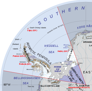
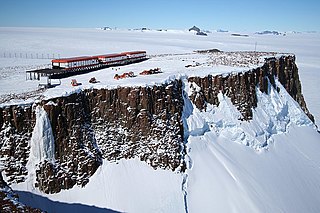
Queen Elizabeth Land is a portion of mainland Antarctica named by the government of the United Kingdom and claimed as part of the British Antarctic Territory. Situated south of Weddell Sea and between longitudes 20°W and 80°W, stretching from Filchner-Ronne Ice Shelf to the South Pole. It is bordered by Zumberge Coast of Ellsworth Land to the West and by Hercules Inlet to the Northwest. To the Northeast, circle of latitude 82°S is the dividing line against Coats Land. The area of Queen Elizabeth Land was unnamed until 2012, though most of it was unofficially known as Edith Ronne Land in 1947–68 and includes areas claimed by the United Kingdom, Chile and Argentina.

Mihaylovski Cove is the 5 km wide cove indenting for 1.3 km the northwest coast of South Bay in Livingston Island, Antarctica that is entered west of Ereby Point and east of Lukovo Point, and has its head fed by Kamchiya Glacier. The area was known to early 19th century sealers who operated from nearby Johnsons Dock. The feature is named after the brothers Petar Mihaylovski, physician at St. Kliment Ohridski base during the 2007/08 and subsequent seasons, and Hristo Mihaylovski, engineer in the national Antarctic campaign during 2015/16 and subsequent seasons.


