
Arthur Harbour
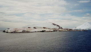
Arthur Harbour ( 64°46′S64°04′W / 64.767°S 64.067°W ) is a small harbour entered between Bonaparte Point and Amsler Island on the south-west coast of Anvers Island in the Palmer Archipelago of Antarctica.
Arthur Harbour ( 64°46′S64°04′W / 64.767°S 64.067°W ) is a small harbour entered between Bonaparte Point and Amsler Island on the south-west coast of Anvers Island in the Palmer Archipelago of Antarctica.
Arthur Harbour was roughly charted by the French Antarctic Expedition (1903–1905) under Jean-Baptiste Charcot. It was surveyed in more detail in 1955 by the Falkland Islands Dependencies Survey (FIDS), who established a station near the head of the harbour. It was named by the United Kingdom Antarctic Place-names Committee (UK-APC) in 1956 after Oswald Raynor Arthur, then Governor of the Falkland Islands. [1]
Station N | |
|---|---|
| Coordinates: 64°45′36″S64°04′48″W / 64.7600°S 64.0800°W | |
| Established | 28 February 1955 |
| Destroyed | 28 December 1971 |
| Government | |
| • Type | Administration |
| • Body | BAS, United Kingdom |
| Active times | All year-round |
Arthur Harbour was the location of the British research Station N, which was active from 28 February 1955 to 10 January 1958. The Station was loaned to the United States government on 2 July 1963. In January 1965, it was converted into a biological laboratory for use by American personnel from nearby Palmer Station. Station N was destroyed by fire on 28 December 1971, while under renovation by the British Antarctic Survey. The debris was removed in 1991, and only concrete foundations now remain. [2]

A number of features in and around Arthur Harbour were named and charted by various Antarctic surveys and expedition groups.
Prior to 2005, Norsel Point was considered the northern headland of Arthur Harbour, but is now considered a part of Amsler Island, just off the coast. [3] [4] Bonaparte Point, named by Charcot for Roland-Napoléon Bonaparte, marks the southern edge of Arthur Harbour. [5] In addition to Amsler Island, Humble Island, Litchfield Island, Torgersen Island, and Dietrich Island are all off the coast of Arthur Harbour.
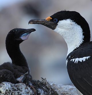
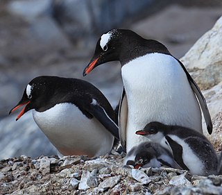
Some 214 ha of land and sea in northern Arthur Harbour, about 1–2 km north-west of Palmer Station, was listed as Important Bird Area (IBA) number 013 by BirdLife International until being delisted in 2015. [6] The site comprised Norsel Point, Humble Island, Breaker Island, Elephant Rocks and Torgersen Island, along with the intervening marine zone. Some of the islands have been designated Restricted Zones within ASMA 7: Southwest Anvers Island and Palmer Basin. The site was an IBA because it supports colonies of breeding seabirds, including Adélie penguins (11,500 pairs), macaroni penguins, southern giant petrels and imperial shags. [7] Litchfield Island remains listed as IBA number 014. [8]
Petermann Island is a small, low and rounded island, lying off the northwest coast of Kyiv Peninsula in Graham Land, Antarctica, a short distance south of Booth Island and the Lemaire Channel. It is a popular tourist destination.

Anvers Island or Antwerp Island or Antwerpen Island or Isla Amberes is a high, mountainous island 61 km long, the largest in the Palmer Archipelago of Antarctica. It was discovered by John Biscoe in 1832 and named in 1898 by the Belgian Antarctic Expedition under Adrien de Gerlache after the province of Antwerp in Belgium. It lies south-west of Brabant Island at the south-western end of the group. The south-western coastline of the island forms part of the Southwest Anvers Island and Palmer Basin Antarctic Specially Managed Area. Cormorant Island, an Important Bird Area, lies 1 km off the south coast.

Palmer Archipelago, also known as Antarctic Archipelago, Archipiélago Palmer, Antarktiske Arkipel or Palmer Inseln, is a group of islands off the northwestern coast of the Antarctic Peninsula. It extends from Tower Island in the north to Anvers Island in the south. It is separated by the Gerlache and Bismarck straits from the Antarctic Peninsula and Wilhelm Archipelago, respectively. The archipelago is in the British, Chilean, and Argentine Claims.
Breaker Island is a small rocky island lying in Arthur Harbour close south-west of Norsel Point, off the south-west coast of Anvers Island in the Palmer Archipelago of Antarctica. It was surveyed by the Falkland Islands Dependencies Survey (FIDS) in 1955 and named by the UK Antarctic Place-Names Committee (UK-APC) because the island causes breakers when the sea is rough.
Dream Island is an island lying 0.7 km (0.43 mi) south-east of Cape Monaco, off the south-west coast of Anvers Island in Wylie Bay, in the Palmer Archipelago of Antarctica. It was surveyed by the British Naval Hydrographic Survey Unit in 1956-1957 and named by the UK Antarctic Place-Names Committee for its natural features including a cave and, in summer, a small waterfall, with mossy patches and grass. It lies about 10 km north-west of the United States' Palmer Station.
Cormorant Island is a 10 ha island lying in Bismarck Strait 1 km south of Anvers Island, 4 km (2.5 mi) east-south-east of Bonaparte Point, in the Palmer Archipelago of Antarctica. It lies some 5 km to the south-east of the United States' Palmer Station in Arthur Harbour on Anvers Island. It was shown on an Argentine government chart of 1954, but not named. It was named by the United Kingdom Antarctic Place-names Committee (UK-APC) in 1958 because of the large number of cormorants (shags) seen there.
Humble Island is a small rocky island lying 0.74 km (0.4 nmi) south-east of Norsel Point on Amsler Island, off the south-west coast of Anvers Island in the Palmer Archipelago of Antarctica. Humble Island was surveyed by the Falkland Islands Dependencies Survey (FIDS) in 1955. Humble Island was named by the United Kingdom Antarctic Place-names Committee (UK-APC) in 1956 because the island seems to be squeezed insignificantly between Litchfield Island and what was then considered the coast of Anvers Island.

Litchfield Island is a rocky island 0.9 kilometres (0.5 nmi) long and rising to 50 m (164 ft), lying in Arthur Harbour, 0.9 kilometres (0.5 nmi) south of Norsel Point, off the south-west coast of Anvers Island in the Palmer Archipelago of Antarctica.
Torgersen Island is a small rocky island lying just east of Litchfield Island in the entrance to Arthur Harbour, off the south-west coast of Anvers Island in the Palmer Archipelago of Antarctica. It was surveyed by the Falkland Islands Dependencies Survey in 1955 and named by the UK-APC for Torstein Torgersen, first mate of the Harbor in late February 1955, preceding the vessel Norsel in one of the ship's boats and making soundings.
The Trojan Range is a mountain range rising to 2,760 metres (9,055 ft), extending northward from Mount Francais along the east side of Iliad Glacier, Anvers Island, in the Palmer Archipelago of the British Antarctic Territory. It was surveyed by the Falkland Islands Dependencies Survey (FIDS) in 1955 and named by the UK Antarctic Place-Names Committee (UK-APC) for the Trojans, one of the opposing sides in the Trojan War in Homer's Iliad.
Amsler Island is a small island off the south coast of Anvers Island in the Palmer Archipelago of Antarctica. It sits between Loudwater Cove and Arthur Harbour.
Wylie Bay is a bay 4 nautical miles (7 km) wide, lying between Cape Monaco and Norsel Point on the southwest coast of Anvers Island, in the Palmer Archipelago. First charted by the French Antarctic Expedition under Charcot, 1903–1905, it was named by the United Kingdom Antarctic Place-Names Committee (UK-APC) in 1959 for John P. Wylie, Falkland Islands Dependencies Survey (FIDS) surveyor at Arthur Harbor in 1956 and 1957.
The Joubin Islands are a group of small islands lying 6 kilometres (3 nmi) south-west of Cape Monaco, Anvers Island, at the south-western end of the Palmer Archipelago of Antarctica. The islands were discovered by the French Antarctic Expedition, 1903–05, under Jean-Baptiste Charcot, and named by him for Louis Joubin, the French naturalist. They have been designated a Restricted Zone under ASMA 7 — Southwest Anvers Island and Palmer Basin — which includes the marine area extending 50 metres (55 yd) from the shorelines.
Guépratte Island is an ice-covered island 2.8 km (1.7 mi) long, lying between Anvers Island and Brabant Island at the east side of the entrance to Fournier Bay, in the Palmer Archipelago, Antarctica. The island was first shown on the Ludwig Friederichsen map of 1895, embodying the 1873–74 explorations of a German expedition under Eduard Dallmann. It was later charted by the French Antarctic Expedition, 1903–05, under Jean-Baptiste Charcot, who named it after Captain Guépratte of the French Navy. The name "Discovery Island", applied in 1927 by Discovery Investigations personnel on the Discovery, has been rejected in favour of the earlier name.
Gourdon Peninsula is a snow-covered peninsula 6 nautical miles (11 km) long, forming the southeast side of Lapeyrere Bay on the northeast coast of Anvers Island, in the Palmer Archipelago, Antarctica. The northeast coast of Anvers Island was roughly surveyed by the French Antarctic Expedition under Jean-Baptiste Charcot in 1905 and the name "Pointe Gourdon," for Vice-Admiral Gourdon of the French Navy, was given to a point between Lapeyrere Bay and Fournier Bay. The UK Antarctic Place-Names Committee in 1956 altered the name to Gourdon Peninsula and applied it to the peninsula described, which almost certainly is the feature Charcot had in mind when he gave the original name.

Gerlache Island is the largest of the Rosenthal Islands lying off Gerlache Point on the west coast of Anvers Island, in the Palmer Archipelago of Antarctica. It was first roughly charted and named "Pointe de Gerlache" by the French Antarctic Expedition, 1903–05, under Jean-Baptiste Charcot, for Lieutenant Adrien de Gerlache. As a result of surveys by the Falkland Islands Dependencies Survey in 1956–58, this island is considered to be the feature named by Charcot; there is no prominent point in this vicinity which would be visible from seaward.
Hero Inlet is a narrow inlet at the south side of Palmer Station between Gamage Point and Bonaparte Point, along the southwest side of Anvers Island in Antarctica. It was named by the Advisory Committee on Antarctic Names after the Research Vessel Hero which, during the 1960s and 1970s, used the inlet as a turning basin when docking at Palmer Station.
Hooper Glacier is a glacier 3 nautical miles (6 km) long, flowing from the col north of Mount William into the west side of Börgen Bay, Anvers Island, in the Palmer Archipelago, Antarctica. It was surveyed by the Falkland Islands Dependencies Survey (FIDS) in 1955, and named by the UK Antarctic Place-Names Committee for Peter R. Hooper of FIDS, leader and geologist at the Arthur Harbour station in 1955 and 1956. Gateway Ridge separates Hooper Glacier from William Glacier.
The Rosenthal Islands are a group of about islands fringing the west coast of Anvers Island, 11 km (6.8 mi) north of Cape Monaco, in the Palmer Archipelago of Antarctica.
Southwest Anvers Island and Palmer Basin is a 3275 km2 Antarctic Specially Managed Area. It lies towards the northern end of the Antarctic Peninsula, encompassing the south-western coastline of Anvers Island, in the Palmer Archipelago, with the adjacent deep marine waters of the Palmer Basin, the shallower Bismarck Strait, and fringing island groups.
| | This Anvers Island location article is a stub. You can help Wikipedia by expanding it. |
